English 2.28MB - Center for International Forestry Research
English 2.28MB - Center for International Forestry Research
English 2.28MB - Center for International Forestry Research

You also want an ePaper? Increase the reach of your titles
YUMPU automatically turns print PDFs into web optimized ePapers that Google loves.
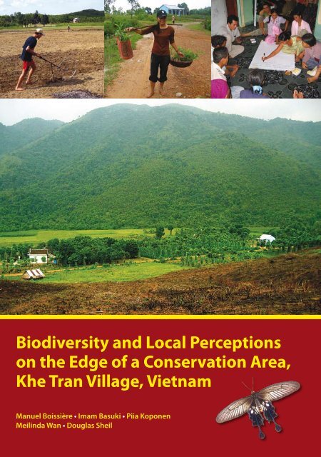
Biodiversity and Local Perceptions<br />
on the Edge of a Conservation Area,<br />
Khe Tran Village, Vietnam<br />
Manuel Boissière • Imam Basuki • Piia Koponen<br />
Meilinda Wan • Douglas Sheil
National Library of Indonesia Cataloging-in-Publication Data<br />
Boissière, Manuel<br />
Biodiversity and local perceptions on the edge of a conservation area, Khe<br />
Tran village, Vietnam/ by Manuel Boissière, Imam Basuki, Piia Koponen,<br />
Meilinda Wan, Douglas Sheil. Bogor, Indonesia: <strong>Center</strong> <strong>for</strong> <strong>International</strong><br />
<strong>Forestry</strong> <strong>Research</strong> (CIFOR), 2006.<br />
ISBN 979-24-4642-7<br />
106p.<br />
CABI thesaurus: 1. nature reserve 2. nature conservation<br />
3. landscape 4. biodiversity 5. assessment 6. community involvement<br />
7. Vietnam I. Title<br />
© 2006 by CIFOR<br />
All rights reserved.<br />
Printed by Inti Prima Karya, Jakarta<br />
Revised edition, June 2006<br />
Design and layout by Catur Wahyu and Gideon Suharyanto<br />
Photos by Manuel Boissière and Imam Basuki<br />
Maps by Mohammad Agus Salim<br />
Cover photos, from left to right:<br />
- A villager prepares the soil <strong>for</strong> peanut plantation in a <strong>for</strong>mer rice field, Khe Tran<br />
- A young woman carries Acacia seedling ready to be planted<br />
- Villagers discuss the future of Phong Dien Nature Reserve<br />
- The different land types in Khe Tran: bare land, village with home gardens, rice fields, and<br />
protected mountain areas<br />
Published by<br />
<strong>Center</strong> <strong>for</strong> <strong>International</strong> <strong>Forestry</strong> <strong>Research</strong><br />
Jl. CIFOR, Situ Gede, Sindang Barang<br />
Bogor Barat 16680, Indonesia<br />
Tel.: +62 (251) 622622; Fax: +62 (251) 622100<br />
E-mail: ci<strong>for</strong>@cgiar.org<br />
Web site: http://www.ci<strong>for</strong>.cgiar.org
Contents<br />
Acronyms and terms vii<br />
Acknowledgements ix<br />
1. <strong>Research</strong> context and objectives 1<br />
2. Methods 3<br />
Village activities 3<br />
Field activities 4<br />
3. Achievements 8<br />
4. Conservation context in Khe Tran 10<br />
4.1. Previous conservation activities 10<br />
4.2. Government programs that affected Khe Tran village 12<br />
Summary 14<br />
5. Site description 15<br />
5.1. <strong>Research</strong> site 15<br />
5.2. People from Khe Tran 17<br />
5.3. Land use and natural resources 23<br />
Summary 28<br />
6. Local perceptions of the different land types and resources 29<br />
6.1. Local land uses 29<br />
6.2. Land type importance 31<br />
6.3. Forest importance 32<br />
6.4. Forest importance in the past, present and future 34<br />
6.5. Importance according to source of products 36<br />
6.6. Most important products from the <strong>for</strong>est 37<br />
6.7. Threats to local <strong>for</strong>ests and biodiversity 41<br />
6.8. People’s hopes <strong>for</strong> the future of their <strong>for</strong>est and life 42<br />
Summary 45<br />
iii
iv | Contents<br />
7. Characterization of land types 46<br />
7.1. Sampling of land types 46<br />
7.2. Specimen collection and identification 48<br />
7.3. Plant biodiversity 51<br />
7.4. Forest structure 53<br />
7.5. Species vulnerability 55<br />
Summary 58<br />
8. Ethno-botanical knowledge 59<br />
8.1. Plant uses 59<br />
8.2. Species with multiple uses 61<br />
8.3. Uses of trees 62<br />
8.4. Uses of non-trees 62<br />
8.5. Forest as resource of useful plants 64<br />
8.6. Nonsubstitutable species 65<br />
8.7. Remarks on potential uses of species 66<br />
Summary 66<br />
9. Local perspectives on conservation 67<br />
Summary 70<br />
10. Conclusion and recommendations 71<br />
10.1. Conclusion 71<br />
10.2. Recommendations 75<br />
Bibliography 77<br />
Annexes 79<br />
1. LUVI (mean value) of important plant species by different use<br />
categories (result based on scoring exercise of four groups of in<strong>for</strong>mant) 79<br />
2. LUVI (mean value) of important animal species by different use<br />
categories based on scoring exercise of four groups of in<strong>for</strong>mant 83<br />
3. The botanical names, families and local name of specimens collected<br />
within and outside the plots by their use categories 84
Tables and figures<br />
Tables<br />
Biodiversity and Local Perceptions | v<br />
1. Composition of MLA research team in Khe Tran village 3<br />
2. Important events affecting the local livelihoods 21<br />
3. Income range by source of products and settlement area 22<br />
4. Identified land types in Khe Tran 24<br />
5. Regrouped land types in Khe Tran 25<br />
6. Important <strong>for</strong>est plants and their local uses 30<br />
7. Main categories of use of plant and animal resources 30<br />
8. Local importance of land types by use category (all groups) 33<br />
9. Forest importance by use categories (all groups) 33<br />
10. Forest importance over time according to different use categories<br />
(all groups) 35<br />
11. Importance (%) of source of product by gender 37<br />
12. Most important <strong>for</strong>est plants and animals in Khe Tran (all groups) 39<br />
13. Most important <strong>for</strong>est plants by categories of use (all groups) 40<br />
14. Most important <strong>for</strong>est animals by categories of use (all groups) 40<br />
15. Locally important plant species by use category and IUCN list<br />
of threatened trees 41<br />
16. Villagers’ perception on threats to <strong>for</strong>est and biodiversity (19 respondents) 42<br />
17. Villagers’ perception about <strong>for</strong>est loss (19 respondents) 43<br />
18. Villagers’ ideas on threats to human life (19 respondents) 43<br />
19. Summary of specimen collection and identification of plant species<br />
from 11 sample sites 50<br />
20. Plant richness in Khe Tran 53<br />
21. Main tree species based on basal area and density listed with their<br />
uses in Khe Tran 54<br />
22. Richness (total number of species recorded per plot) of life <strong>for</strong>ms<br />
of non-tree species in all land types in Khe Tran 55<br />
23. Threatened species in Khe Tran based on vegetation inventories<br />
and PDM exercises 57<br />
24. Summary of specimen collection and identification of plant species<br />
from 11 sample sites 59<br />
25. Mean number of species and number of useful species recorded<br />
in each land type 60<br />
26. Distribution of all useful plant species per plot and by use category 61<br />
27. Plant species with at least four uses 62<br />
28. Distribution of tree species considered useful per plot and per use category 63<br />
29. Distribution of non-tree species considered useful per plot and per use<br />
category 64<br />
30. Villager’s perceptions on conservation and Phong Dien Nature Reserve 69
vi | Contents<br />
Figures<br />
1. Scoring exercise (PDM) with Khe Tran men group 5<br />
2. Working on sample plot 6<br />
3. Location of Khe Tran village in the buffer zone of Phong Dien<br />
Nature Reserve 16<br />
4. Situation of Khe Tran village 18<br />
5. Livestock and Acacia plantations are important in Khe Tran 20<br />
6. A woman from the lower part of the village harvests rubber<br />
from her plantation 22<br />
7. Considerable areas of bare land are used in Khe Tran <strong>for</strong> new<br />
Acacia plantation 25<br />
8. Biodiversity and resource distribution map of Khe Tran 27<br />
9. Land type by importance (all groups) 31<br />
10. Importance of <strong>for</strong>est types (all groups) 32<br />
11. Forest importance over time (all groups) 35<br />
12. Source of product importance (all groups) 37<br />
13. Importance of <strong>for</strong>est resources by use categories (all groups) 38<br />
14. Recent flood on a bridge between Phong My and Khe Tran 44<br />
15. Field sampling of land types in Khe Tran (total sample size 11 plots) 47<br />
16. Distribution of sample plots in the research area 49<br />
17. Accumulation of non-tree species with the increasing random<br />
order of subplots (each 20 m 2 ) <strong>for</strong> various land types in Khe Tran 50<br />
18. Relative dominance in primary and secondary <strong>for</strong>est plots in Khe Tran<br />
based on basal area 52<br />
19. Forest structural characteristics in Khe Tran. Left panel: basal area and<br />
density; right panel: tree height, stem diameter and furcation index 56<br />
20. All plant species considered useful by the Khe Tran villagers shown<br />
in use categories 63<br />
21. Total number of all useful plant species per category in primary,<br />
secondary and plantation <strong>for</strong>ests 65
Acronyms and terms<br />
asl above sea level<br />
CBEE Community-Based Environmental Education<br />
CIFOR <strong>Center</strong> <strong>for</strong> <strong>International</strong> <strong>Forestry</strong> <strong>Research</strong><br />
CIRAD Centre de coopération <strong>International</strong>e en Recherche Agronomique<br />
pour le Développement<br />
dbh diameter at breast height<br />
DPC District Peoples Committee<br />
ETHZ Eidgenössische Technische Hochschule Zürich (Federal Institute of<br />
Technology in Zürich)<br />
ETSP Extension and Training Support Project<br />
FIPI <strong>Forestry</strong> Inventory and Planning Institute<br />
FPD Forest Protection Department<br />
GoV Government of Vietnam<br />
HUAF Hue University of Agriculture and <strong>Forestry</strong><br />
IUCN <strong>International</strong> Union <strong>for</strong> Conservation of Nature and Natural<br />
Resources<br />
Land type component of landscape that is covered by natural coverage or used<br />
<strong>for</strong> human activities<br />
Land use component of landscape that is used <strong>for</strong> human activities<br />
Landscape holistic and spatially explicit concept that is much more than the<br />
sum of its components e.g. terrain, soil, land type and use<br />
Lowlands village area on the lower reaches of O Lau river<br />
vii
viii | Acronyms and terms<br />
LUVI Local User Value Index<br />
MLA Multidisciplinary Landscape Assessment<br />
NTFP Non-Timber Forest Product<br />
PDM Pebble Distribution Method<br />
PDNR Phong Dien Nature Reserve<br />
PPC Province Peoples Committee<br />
SDC Swiss Development Cooperation<br />
SFE State Forest Enterprises<br />
TBI-V Tropenbos <strong>International</strong>-Vietnam<br />
Uplands village area on the upper reaches of O Lau river<br />
USD US Dollar<br />
Village group of households included in a commune (subdistrict level) but<br />
not recognised as a legal entity in Vietnam<br />
VND Vietnamese Dong (USD 1 approximately equals to VND 15,700)<br />
WWF World Wildlife Fund
Acknowledgements<br />
We would like to express our profound gratitude to individuals and institutions <strong>for</strong><br />
their assistance in the course of undertaking this research. We wish to thank the<br />
representatives of the Government of Vietnam, the Provincial Peoples Committee<br />
(PPC) of Thua Thien Hue province, Peoples Committee of Phong Dien district<br />
and Phong My commune <strong>for</strong> their interest in our work.<br />
Our appreciations are addressed to Tran Huu Nghi, Jinke van Dam, Tu<br />
Anh, Nguyen Thi Quynh Thu, from Tropenbos <strong>International</strong> Vietnam, <strong>for</strong> their<br />
cooperation and <strong>for</strong> their assistance in organising our surveys.<br />
We were lucky to collaborate with all the MLA participants: Le Hien (Hue<br />
University of Agriculture and <strong>Forestry</strong>), Ha Thi Mung (Tay Nguyen University),<br />
Vu Van Can, Nguyen Van Luc (FIPI), Nguyen Quy Hanh and Tran Thi Anh<br />
Anh (Department of Foreign Affairs of Thua Thien Hue province), and Ho Thi<br />
Bich Hanh (Hue College of Economics) <strong>for</strong> their hard work and interest <strong>for</strong> the<br />
project.<br />
We would like to thank Patrick Rossier (ETSP-Helvetas), Eero Helenius<br />
(Thua Thien Hue Rural Development Programme), and Chris Dickinson (Green<br />
Corridor Project-WWF), <strong>for</strong> their useful suggestions.<br />
We wish to thank Ueli Mauderli (SDC), Jean Pierre Sorg (ETHZ), <strong>for</strong> their<br />
useful comments and suggestions during their survey in Khe Tran, Jean-Laurent<br />
Pfund and Allison Ford (CIFOR) <strong>for</strong> their valuable comments during the redaction<br />
of the report, Michel Arbonnier (CIRAD) <strong>for</strong> the revision of the plant list, Henning<br />
Pape-Santos, our copy-editor, and Wil de Jong, the coordinator of the project <strong>for</strong><br />
his support.<br />
Last but not the least, we would like to thank the villagers from Khe Tran, Son<br />
Qua and Thanh Tan <strong>for</strong> their cooperation during our different surveys, <strong>for</strong> their<br />
patience and <strong>for</strong> all the in<strong>for</strong>mation they provided to us.<br />
ix
. <strong>Research</strong> context and objectives<br />
Vietnam has been re<strong>for</strong>ming its <strong>for</strong>est management in favour of household and<br />
local organization (Barney 2005). The government increasingly gives local people<br />
the right to manage the <strong>for</strong>ests. Un<strong>for</strong>tunately, in this changing environment,<br />
recognition of local people’s rights is still limited and local knowledge and<br />
perspectives are rarely taken into account by the state institutions implementing<br />
land titling and decentralization. The challenge is to better in<strong>for</strong>m each stakeholder<br />
on the perspectives of people living in and near the <strong>for</strong>est on the natural resources<br />
and landscapes. Furthermore, clarification of the local capacity to manage <strong>for</strong>ests<br />
is necessary <strong>for</strong> better in<strong>for</strong>med decision making.<br />
Stakeholder and biodiversity at the local level is a three-year collaboration<br />
between the <strong>Center</strong> <strong>for</strong> <strong>International</strong> <strong>Forestry</strong> <strong>Research</strong> (CIFOR) and the Swiss<br />
Development Cooperation (SDC). Tropenbos <strong>International</strong>-Vietnam (TBI-V)<br />
has been a very helpful collaborator <strong>for</strong> coordinating the project activities. The<br />
project goal is to contribute to the enhancement of the livelihoods of local <strong>for</strong>est<br />
dependent communities and sustainable <strong>for</strong>est management. The project aims to<br />
strengthen local capacity to plan and implement locally relevant <strong>for</strong>est landscape<br />
management as a mechanism to achieve those goals. It focuses on situations where<br />
decentralization has given local government more authority and responsibility <strong>for</strong><br />
<strong>for</strong>ests. The project fosters better engagement by local decision-makers that takes<br />
into consideration the needs and preferences of local people, especially the poor<br />
communities.<br />
Multidisciplinary landscape assessment, or MLA, is a set of methods developed<br />
by CIFOR scientists to determine ‘what is important to local communities, in<br />
terms of landscape, environmental services, and resources’. The approach is<br />
rooted in social (anthropology, ethnobotany and socio-economics) as well as<br />
natural sciences (botany, ecology, geography and pedology); was tested and used<br />
in different countries (Bolivia, Cameroon, Gabon, Indonesia, Mozambique and<br />
Philippines). The methods are fully detailed in four languages: <strong>English</strong>, French,<br />
Indonesia and Spanish (Sheil et al. 2003; http://www.ci<strong>for</strong>.cgiar.org/mla/).
| <strong>Research</strong> context and objectives<br />
MLA helps the project by providing in<strong>for</strong>mation on the way local people<br />
articulate and document their knowledge of land and natural resources uses. Local<br />
knowledge is considered crucial in<strong>for</strong>mation <strong>for</strong> the management of <strong>for</strong>est.<br />
Finally, in this report we aim to provide in<strong>for</strong>mation on the way the local<br />
community in Khe Tran (Phong My commune, Phong Dien district, Thua Thien<br />
Hue province) perceives and manages its environment, and we discuss the options<br />
it has to participate in future nature reserve management.
. Methods<br />
The multidisciplinary approach of MLA gathers in<strong>for</strong>mation on land use in village<br />
and field, and studies local perceptions on <strong>for</strong>est landscapes and resources as well<br />
as local priorities in terms of land management and which land types, resources<br />
and activities are important to local people. The MLA team, working in both<br />
village and field, was composed by scientists from different disciplines (Table 1).<br />
Table 1. Composition of MLA research team in Khe Tran village<br />
Team member Responsibility/research aspect Contact<br />
Manuel Boissière Team coordinator/ethnobotany m.boissiere@cgiar.org<br />
Ha Thi Mung Socio-economy mungbmt@yahoo.com<br />
Imam Basuki Socio-economy i.basuki@cgiar.org<br />
Le Hien Socio-economy Hienle2001@yahoo.com<br />
Meilinda Wan Socio-economy m.wan@cgiar.org<br />
Douglas Sheil Ecology d.sheil@cgiar.org<br />
Piia Koponen Ecology p.koponen@cgiar.org<br />
Nguyen Van Luc Botany vanluc_qh@yahoo.com.vn<br />
Vu Van Can Botany Tel. 04-861-6946<br />
Ho Thi Bich Hanh Translator hanhdhkt@gmail.com<br />
Nguyen Quy Hanh Translator Quyhanh2000@yahoo.com<br />
Tran Thu Anh Anh Translator hianhanh@yahoo.com<br />
Village activities<br />
Consisting of one or two researchers assisted by a translator, the village team was<br />
responsible <strong>for</strong> all socio-economic data collection. The team used questionnaire<br />
and data sheets to interview most households and key in<strong>for</strong>mants and to record
| Methods<br />
the results of community meetings and focus group discussions. In<strong>for</strong>mation was<br />
gathered from each household head on socio-economic aspects (demography,<br />
sources of income and livelihoods) and some other cultural aspects (history of<br />
the village, social organization, stories and myths, religion). The questionnaire<br />
and data sheets also provided basic in<strong>for</strong>mation on local views by gender, threats<br />
against biodiversity and <strong>for</strong>ests, perspectives on natural resource management and<br />
conservation, and land tenure.<br />
Participatory mapping exercises began during the very first days of the survey<br />
with two women and men groups of villagers using two basic maps, assisted by<br />
two research members to explain the objectives of the exercise. They facilitated<br />
the process through discussion with villagers about which resources and land<br />
types to add to the basic maps. These maps were then put together to build a single<br />
map representing the perception of the overall community. During all our onsite<br />
activities, the map was available to any villager <strong>for</strong> adding features and making<br />
corrections. In the case of Khe Tran, we worked a second time with a group of key<br />
in<strong>for</strong>mants to increase the precision of the map, and two young villagers drew the<br />
map again with their own symbols.<br />
Village activities involved:<br />
(a) community meetings to introduce the team and its activities to the village<br />
members, to cover basic in<strong>for</strong>mation on land and <strong>for</strong>est types available,<br />
location of each type (through participatory resources mapping) and categories<br />
of use that people identify <strong>for</strong> each of these landscapes and resources;<br />
(b) personal and small groups interviews to learn about village and land use<br />
history, resource management, level of education, main sources of income,<br />
livelihoods and land utilization system;<br />
(c) focus group discussion on natural resource location, land type identification<br />
by category of uses, people’s perception of <strong>for</strong>ests, sources of products<br />
<strong>for</strong> household consumption and important species <strong>for</strong> different groups of<br />
in<strong>for</strong>mants using the scoring exercise known as ‘pebble distribution method’,<br />
or PDM. PDM was used to quantify the relative importance of land types,<br />
<strong>for</strong>est products and species to local people by distributing 100 pebbles or<br />
beans among illustrated cards representing land types, use categories or<br />
species (Figure 1). In the following tables and figures with in<strong>for</strong>mation from<br />
PDM, the 100% value refers to the total number of pebbles. The pebbles were<br />
distributed by the in<strong>for</strong>mants among the cards according to their importance.<br />
Field activities<br />
The field team consisted of four researchers assisted by one translator, two local<br />
in<strong>for</strong>mants and a field assistant. This team was responsible <strong>for</strong> botany, ethnobotany<br />
and site history data collection. It gathered in<strong>for</strong>mation through direct<br />
observations, measurements and interviews in each sample plot using structured<br />
datasheets.
Figure 1. Scoring exercise (PDM) with Khe Tran men group<br />
Biodiversity and Local Perceptions |<br />
Activities in the field were decided on and set up in accordance with<br />
in<strong>for</strong>mation collected in the village. The field team collected data from sample<br />
plots (Figure 2). The team chose plot locations after the different land types had<br />
been identified by the villagers. Sampling of land types took into account the main<br />
categories of the land types and sites where the most important resources could<br />
be found. Village in<strong>for</strong>mants accompanying the field team provided details on<br />
history and land use of each site, as well as the uses and names of the main <strong>for</strong>est<br />
products that were traditionally collected there. Although the sampling ef<strong>for</strong>t was<br />
distributed across most of the land types, <strong>for</strong>est habitats were given emphasis<br />
since they cover the largest area and generally house more species per sample<br />
than other land types. Most of the land types were sampled with one (rice field,<br />
primary <strong>for</strong>est) or two plots, in total 11 plots were surveyed with 110 subplots.<br />
For each plot a general site description with tree and non-tree data and detailed<br />
ethno-ecological in<strong>for</strong>mation was composed and plot position was recorded with<br />
GPS. Plots consisted of 40 m transects subdivided into 10 consecutive 5 m wide<br />
subunits, where the presence of all herbs, climbers with any part over 1.5 m long<br />
and other smaller plants was recorded. Trees with a diameter at breast height (dbh)<br />
of 10 cm or more were censused and their height and diameter measured using the<br />
same base-transect but variable area subunits (Sheil et al. 2003).<br />
Collaboration between village team and field team was crucial to the collection of<br />
relevant in<strong>for</strong>mation, but collaboration with villagers was also important to link<br />
the data collected by direct measurements with those coming from discussions,
| Methods<br />
Figure 2. Working on sample plot<br />
interviews and questionnaires. Preparation of the final reference list of plants with<br />
their corresponding local-language names took considerable time because of the<br />
mixture of Vietnamese language and Pahy language used by the local people.<br />
Some specimens identified to one species had several local names (e.g. Ageratum<br />
conyzoides) and other specimens with one local name belonged to different species<br />
(e.g. Fibraurea tinctoria and Bowringia sp.). A. conyzoides was given two local<br />
names (Cá hỡi and Sắc par abon) by different in<strong>for</strong>mants at different sites along<br />
with different uses. (Being bad <strong>for</strong> soil, Cá hỡi has few uses, while Sắc par abon<br />
was mentioned as potential fertilizer <strong>for</strong> sweet potato, although another in<strong>for</strong>mant<br />
said that it is actually not used by villagers). Catimbium brevigulatum, which was<br />
recorded in seven plots, had four different local names (A kai, A xây cỡ, Betre,<br />
Papan). Although in<strong>for</strong>mants were reliable and persistent in their ways of naming<br />
species, both gender and different experiences caused variation and the mixture of<br />
different languages (mainly Pahy and Vietnamese) was sometimes confusing <strong>for</strong><br />
the researchers. The ethno-botanical survey was conducted simultaneously in the<br />
field, where we had in total 12 in<strong>for</strong>mants, normally two or more at the same time<br />
with both genders represented. This was important to ensure the broad sampling<br />
of knowledge about uses and sites. As an example, genus Bowringia, which was<br />
present in four plots in two land types (secondary <strong>for</strong>est and primary <strong>for</strong>est), had<br />
no use according to five in<strong>for</strong>mants, whereas two in<strong>for</strong>mants said it was used as<br />
firewood and its roots could be sold.
Biodiversity and Local Perceptions |<br />
From each plot plant specimens <strong>for</strong> further herbarium identification were<br />
collected. The entire specimen collection has been left with botanist Vu Van Can in<br />
Hanoi. All specimens were conserved in alcohol be<strong>for</strong>e drying and identification.<br />
Some specimens were identified in the field, others later in Hanoi. Genus and<br />
species names follow the nomenclature used in Iconographia Cormophytorum<br />
Sinicorum (Chinese Academy of Science, Institute of Plant <strong>Research</strong> 1972–<br />
1976), Cây cỏ Việt Nam (Pham Hoang Ho 1993), Vietnam Forest Trees (Forest<br />
Inventory and Planning Institute 1996), Yunnan Kexue Chubanshe (Yunnan Shumu<br />
Tuzhi 1990) and the <strong>International</strong> Plant Names Index database (http://www.ipni.<br />
org/); and family names in The plant-book: a portable dictionary of the vascular<br />
plants (Mabberley 1997) and the <strong>International</strong> Plant Names Index database<br />
except Leguminosae sensu lato, which follows the subfamily categorization of<br />
Mimosaceae, Fabaceae sensu stricto and Caesalpiniaceae.<br />
The study in Khe Tran covered two periods, from 15 May to 9 June 2005 and<br />
from 2 to 15 October 2005. The first period was reserved mainly <strong>for</strong> data collection<br />
on the importance of local land types, while during the second period we focused<br />
more on quality control and biodiversity and conservation aspects according to<br />
local people. During both periods, commune officers joined the research team to<br />
make sure that we were safe. Even if their presence was not directly useful to our<br />
research, it was an opportunity <strong>for</strong> researchers to socialize with local authorities<br />
and discuss local perspectives on biodiversity and land types.
. Achievements<br />
During the project, our objectives were to<br />
(a) test and adapt the MLA method as an appropriate mechanism <strong>for</strong><br />
integrating local perceptions and views in decision making and planning.<br />
The method was successfully tested in the rural context of Khe Tran, and even<br />
if the MLA was originally designed <strong>for</strong> assessments of local perceptions and<br />
priorities of <strong>for</strong>est dependant societies in a tropical context, we have shown<br />
here that the method can be adapted to situations where local communities<br />
rely less on the <strong>for</strong>est products than they used to;<br />
(b) provide baseline data that can be used <strong>for</strong> the biodiversity conservation<br />
of the planned Phong Dien Nature Reserve. We have a considerable data<br />
base from our different surveys in Khe Tran, with an amount of important<br />
in<strong>for</strong>mation on local priorities and perceptions, on the richness of the vegetation<br />
in the village’s vicinity, on the uses of <strong>for</strong>est and non-<strong>for</strong>est products by the<br />
local people as well as on the economic, social and demographic data of the<br />
village. Seven hundred and fifty-four specimens of plants were recorded,<br />
consisting of 439 species from 108 families, <strong>for</strong> which we registered 824<br />
uses. All these data, including socio-economic data will be valuable <strong>for</strong> the<br />
successful management of the planned nature reserve, providing in<strong>for</strong>mation<br />
on the biodiversity in the buffer and core zones, and on the different uses and<br />
valuation of species and of natural resources by the local people;<br />
(c) provide an overview of the importance of landscape and local species<br />
to the people of Khe Tran and collect in<strong>for</strong>mation on their livelihoods<br />
and perspectives on Phong Dien Nature Reserve. Through community<br />
meetings, participatory mapping and scoring exercises, the landscape of the<br />
research area has been studied. Findings reflect the local point of view and
Biodiversity and Local Perceptions |<br />
relative importance of each category of use. Direct field observations using<br />
systematic sampling supported the recorded local views of the importance of<br />
different species, land types and spatial design of the landscape;<br />
(d) discuss the opportunities and constraints faced by conservation<br />
institutions in the future nature reserve regarding land allocation and<br />
<strong>for</strong>est rehabilitation schemes. Dialogue with local in<strong>for</strong>mants occurred<br />
during the survey, in focus group discussion, interviews and more in<strong>for</strong>mal<br />
discussions, to understand the local priorities and perspectives facing the<br />
future nature reserve planning. A workshop with local people was held at the<br />
end of the survey to discuss the implications of conservation according to<br />
the local point of view, the options <strong>for</strong> local people in the frame of the future<br />
nature reserve, the role they would like to play and the threats to biodiversity<br />
they identified; and<br />
(e) facilitate greater involvement of local people and other stakeholders in<br />
decision making and planning at the local level. Based on survey results,<br />
workshops will be held at the provincial, communal and village levels to share<br />
our in<strong>for</strong>mation and experience with all interested partners, stakeholders and<br />
decision makers, and discussions will be held to look <strong>for</strong> options to involve<br />
local communities in reserve management. Be<strong>for</strong>e these workshops another<br />
part of the project, called Future Scenario, was implemented as a follow-up<br />
of our activity in Khe Tran (Evans 2006). Future Scenario helped the local<br />
community in Khe Tran to build strategies <strong>for</strong> their future based on local<br />
knowledge and preliminary MLA results. A presentation of the local people’s<br />
future scenario was made to the local authorities (commune officers).<br />
Be<strong>for</strong>e we analyse the survey results, it is necessary to better understand the<br />
context of conservation in the Phong Dien area and who the villagers of Khe Tran<br />
are.
4.1. Previous conservation activities<br />
Government of Vietnam (GoV) policies have affected the <strong>for</strong>est-related activities<br />
of Khe Tran village. Prior to 1992, the upland <strong>for</strong>est, one of the last remaining<br />
patches of lowland evergreen <strong>for</strong>est including and adjacent to Khe Tran, was<br />
considered a ‘productive <strong>for</strong>est’ and managed by logging companies under the<br />
Department of <strong>Forestry</strong> at the province level. Then in 1992 this site, ‘dominated by<br />
a ridge of low mountains, which extends south-east from the Annamite mountains<br />
and <strong>for</strong>ms the border between Quang Tri and Thua Thien Hue provinces’, was<br />
recognised <strong>for</strong> its ‘important role in protecting downstream water supplies and<br />
reducing flooding in the lowlands of Thua Thien Hue province’ and designated as<br />
a ‘watershed protection <strong>for</strong>est’, a status it still has (Le Trong Trai et al. 2001).<br />
In 1998, international bird conservation groups focused attention on the site<br />
after rediscovery of Edward’s Pheasant (Lophura edwardsi) in these hills, a fowl<br />
thought extinct. Today the site is part of a government <strong>for</strong>est strategy to create a<br />
system of 2 million ha of special use <strong>for</strong>est (national parks, nature reserves and<br />
historical sites) throughout the country and it is listed as one of the sites destined<br />
to become a nature reserve (41,548 ha) in 2010 (Barney 2005).<br />
Local <strong>for</strong>ests around Khe Tran are one of the key biodiversity areas of the<br />
province, since many rare and endangered species of plants and animals can be<br />
found there. Le Trong Trai et al. (2001) report that significant numbers of endemic<br />
and nonendemic plants, mammals, birds, reptiles, amphibians and butterflies are<br />
found in Phong Dien <strong>for</strong>ests including Khe Tran. Endangered tiger, Panthera<br />
tigris, was confirmed to be present in this area. Muoc, who belongs to the Pahy<br />
ethnic group from Khe Tran, reported that in March 1998 he observed a tiger of<br />
approximately 100 kg at 200 meters from his village. He also reported that in May<br />
1998 a tiger preyed on one of his buffalo in the Moi valley (16°27’N 107°15’E).<br />
He further noticed that, judging by the footprints, two adults and one cub were<br />
present. Villagers also reported during our survey the regular presence of some<br />
of the globally threatened green peafowl (Pavo muticus), although these reports<br />
0<br />
. Conservation context in Khe Tran
Biodiversity and Local Perceptions |<br />
remain unconfirmed. Some of these key biodiversity species are closely related to<br />
the livelihood of the local people. Our study analyses this kind of knowledge.<br />
First among the threats to <strong>for</strong>est biodiversity identified by BirdLife<br />
<strong>International</strong> and the Forest Inventory and Planning Institute (FIPI) is hunting,<br />
because of the value and rarity of the game, followed by firewood and other nontimber<br />
<strong>for</strong>est product (NTFP) collection, timber cutting, <strong>for</strong>est fires (including<br />
human-made as part of scrap metal collection) and clearance of <strong>for</strong>est land <strong>for</strong><br />
agriculture (Le Trong Trai et al. 2001). But the threats are usually specific to each<br />
site, and detailed in<strong>for</strong>mation is needed <strong>for</strong> each location, as we did in Khe Tran.<br />
In June and July 2001, the nature reserve project team including the project<br />
leader and two local people, in collaboration with the Phong Dien Forest Protection<br />
Department (FPD), conducted hunting surveys in Khe Tran and other parts of the<br />
future Phong Dien Nature Reserve (PDNR). <strong>International</strong> Nature Conservation<br />
made this investigation in the frame of a project named ‘Understanding the<br />
impacts of Hunting on Edwards’s Pheasant Lophura edwardsi at PDNR, Vietnam:<br />
Towards a Strategy <strong>for</strong> Managing Hunting Activities’. Interviews were conducted<br />
with villagers, village leader, hunters/trappers (hereinafter called hunters) and<br />
wildlife traders. Villagers also helped to cross-check in<strong>for</strong>mation obtained in the<br />
field. During the initial meetings with hunters in the future core zone, the team<br />
was accompanied by a local guide. The guide helped to introduce the survey<br />
and emphasized its scientific nature. This helped the socialization of the team’s<br />
activities and to gain local support and trust (see the report in http://www.ruf<strong>for</strong>d.<br />
org/rsg/Projects/reports/Tran_Quang_Ngoc_Aug_2001.doc).<br />
The Protection Area and Development review, in collaboration with the World<br />
Wildlife Fund (WWF), BirdLife <strong>International</strong> and FPD undertook another field<br />
study in Khe Tran and other specific sites of Thua Thien Hue province in late 2001<br />
and early 2002. The objective was to examine the actual and potential economic<br />
contribution of the protected areas to different economic sectors in the province<br />
and to define important policy and planning issues related to maintaining and<br />
enhancing the development benefits from the protected areas. This in<strong>for</strong>mation<br />
helped policy-makers and planners to understand how their actions could<br />
influence protected area management, local livelihoods and associated economic<br />
development in the areas. A number of case studies also investigated specific<br />
connections between protected areas and economic sectors (see http://www.<br />
mekong-protected-areas.org/vietnam/docs/vietnam-field.pdf).<br />
A project on Community Participation <strong>for</strong> Conservation Success developed by<br />
WWF, Xuan Mai <strong>Forestry</strong> University and FPD used Khe Tran as one of the training<br />
sites in buffer zones. It was designed to increase the effectiveness of conservation<br />
programs in Vietnam by promoting community participation through communitybased<br />
environmental education (CBEE). The project, started in 2003, aimed to<br />
increase the immediate and long-term capacity of government to incorporate<br />
CBEE training into mainstream training institutions. It also contributed directly to<br />
conservation actions in two priority sites in the Central Annamite, by integrating<br />
CBEE activities into the implementation of protected area conservation projects<br />
(Matarasso and Do Thi Thanh Huyen 2005).
| Conservation context in Khe Tran<br />
4.2. Government programs that affected Khe Tran village<br />
Swidden cultivation was a major activity <strong>for</strong> local livelihoods until 1992–1993,<br />
when most of the households were resettled as part of the government’s fixed<br />
cultivation program. Called ‘327 Program’ (1992–1997), it was the first ef<strong>for</strong>t<br />
of the GoV to develop industrial plantations and to decentralize control over and<br />
reallocate benefit-sharing of <strong>for</strong>est resources in Vietnam (Barney 2005), in line<br />
with the ‘Doi Moi’ economic re<strong>for</strong>m (which, with six major economic changes,<br />
helped Vietnam come out of the economic crisis in 1986). Since then most of the<br />
Khe Tran people have concentrated more on their new agriculture and plantation<br />
land and decreased their activity in the natural <strong>for</strong>ests. In this community, there<br />
was little land suitable <strong>for</strong> wet rice cultivation, and villagers began to cultivate<br />
crops such as maize and peanuts, and to diversify crop production with rubber and<br />
Acacia plantations supported by the national 327 Program.<br />
In 2003, according to Artemiev (2003), new guidelines were <strong>for</strong>med on State<br />
Forest Enterprises (SFE) by various government institutions (see Prime Minister<br />
Decision 187/1999/QĐ-TTg from September 1999 and Political Bureau Resolution<br />
28-NQ/TW of 16 June 2003 on the arrangement, renovation and development of<br />
State Farm and Forest Enterprises), which re<strong>for</strong>med its status to<br />
1. business SFE (<strong>for</strong>estry related business), which earns profits as its main<br />
per<strong>for</strong>mance objective and receives no subsidies to cover its operating cost;<br />
2. Protection Forest Management Board (<strong>for</strong>est protection activities), which<br />
combines earned profits and subsidies only <strong>for</strong> cost recovery;<br />
3. other business <strong>for</strong>m (transportation, construction, wood processing,<br />
extension services, etc.), which is similar to business SFE in its objective;<br />
and<br />
4. public utility State Owned Enterprises.<br />
For more than one decade <strong>for</strong>estry activities have been implemented under a<br />
series of national <strong>for</strong>est development programs, most recently the ‘661 Program’<br />
and its predecessor, the 327 Program. In Phong Dien district, the 661 Program<br />
is managed by Phong Dien Forest Enterprise and the management board of Bo<br />
River Watershed Protection Forest (Le Trong Trai et al. 2001). The main <strong>for</strong>estry<br />
activities focused on ‘af<strong>for</strong>esting’ bare lands and degraded areas, and establishing<br />
<strong>for</strong>est plantations. In Khe Tran village, households were paid VND 700,000 to<br />
VND 1 million per hectare <strong>for</strong> planting trees on land allocated <strong>for</strong> plantations<br />
(Acacia spp.). They were then paid a further VND 450,000 <strong>for</strong> the first year and<br />
VND 250,000 <strong>for</strong> each of the next two years under the terms of the <strong>for</strong>est protection<br />
contract (<strong>for</strong> comparison, the average annually per capita income in Khe Tran is<br />
VND 1,944,167). They were not allowed to cut the trees but, in places with older<br />
trees, were allowed to collect fallen branches <strong>for</strong> firewood. In A Luoi district, <strong>for</strong><br />
example, households were paid VND 400 per tree <strong>for</strong> planting cinnamon trees,<br />
which equals VND 4 million/ha (high planting density of Cinnamomum cassia is<br />
10,000 trees/ha; Le Thanh Chien 1996).
Biodiversity and Local Perceptions |<br />
Further, Le Trong Trai et al. (2001) described that payments from these national<br />
<strong>for</strong>estry programs have provided benefits to villagers in the short term, and Acacia<br />
spp. and pine plantations established under these programs are growing reasonably<br />
well. However, villagers brought attention to a number of problems they had to<br />
face in response to the needs of the national <strong>for</strong>estry programs. For example,<br />
villagers from Khe Tran and Ha Long pointed out that they faced considerable<br />
difficulties after their individual agreement (temporary Land Use Certificate)<br />
on plantation with the Forest Enterprise expired, and they were left without any<br />
further incentive. This kind of agreement does not provide any official recognition<br />
of the local people’s rights to the land, and they only have the right to use the<br />
land, temporarily, <strong>for</strong> the time of the agreement. These same villagers expressed<br />
a preference <strong>for</strong> natural <strong>for</strong>est management approaches that deliver sustainable<br />
and regular benefits and allow them to manage existing <strong>for</strong>est land (including<br />
regenerating <strong>for</strong>est and ‘bare’ lands) in a more sustainable manner.<br />
In Phong Dien district, the main species <strong>for</strong> plantation establishment are<br />
Acacia auriculi<strong>for</strong>mis, Acacia mangium and Pinus kesiya, selected by project<br />
managers of the national <strong>for</strong>estry programs. The total area under <strong>for</strong>est plantation<br />
is substantial: according to Phong Dien Forest Enterprise, 30,366 ha of plantations<br />
have now been established in the three communes of Phong Dien district near the<br />
buffer zone, with support from the 327 and 661 programs. Most plantations have<br />
been established on flat lands and lower slopes, <strong>for</strong> accessibility and financial<br />
reasons.<br />
Rubber trees were also established under the 327 Program in Khe Tran.<br />
Un<strong>for</strong>tunately, according to Le Trong Trai et al. (2001), this plantation was<br />
established on the river banks, the village’s best lands available <strong>for</strong> agriculture<br />
crops. Because the trees already produce latex, villagers are left without any better<br />
option <strong>for</strong> other agriculture. In our survey we observed that beyond the rubber<br />
plantation and the plain area in the lower part of the village, land is composed of<br />
reddish, stony and hard soil surface.<br />
Le Trong Trai et al. (2001) argued that with an abundance of heavily degraded<br />
land available <strong>for</strong> rehabilitation, <strong>for</strong>est management and other land uses, there is<br />
considerable potential <strong>for</strong> cash earning activities in the buffer zone (<strong>for</strong> example<br />
through economic crop plantations). This activity would also reduce the overall<br />
pressure on the <strong>for</strong>est resources in the nature reserve. They also suggested that<br />
current arrangements <strong>for</strong> <strong>for</strong>est development and management in the bare lands<br />
are costly, create social tensions and seem to be unsustainable in the long run.<br />
On the other hand some of the Acacia plantations have been established in areas<br />
that are not optimal from environmental or economical perspectives. This practice<br />
may lead to increasing conflicts, especially as land pressure <strong>for</strong> crops continues<br />
to increase. Consideration might, there<strong>for</strong>e, be given to allocating a greater<br />
proportion of existing <strong>for</strong>est lands <strong>for</strong> community management.
| Conservation context in Khe Tran<br />
Summary<br />
Khe Tran village has been through different land use policies. Its <strong>for</strong>ests were<br />
first considered productive <strong>for</strong>ests, then watershed protection <strong>for</strong>ests, and<br />
it is planned to be part of Phong Dien Nature Reserve in 2010, because of<br />
its important biodiversity and the presence of rare and endangered species.<br />
However, <strong>for</strong>ests in the village’s surroundings have been deeply disturbed,<br />
because of war, logging activities and agricultural practices. Many projects<br />
linked to the preparation of the nature reserve have taken place in Khe Tran.<br />
Banning local people from many extractive activities in the planned reserve,<br />
the government has proposed to develop other activities to provide incomes<br />
to all households. In this context, rubber and Acacia plantation programs were<br />
implemented with government support. Even if these programs are supposed<br />
to provide cash income to the local people, some villagers worry about their<br />
future rights on the plantations and expect to get rights to manage the natural<br />
<strong>for</strong>ests and the bare land in a sustainable way. Lack of land <strong>for</strong> agriculture may<br />
become a problem <strong>for</strong> food security and may leave many villagers with few<br />
alternatives to the exploitation of the natural <strong>for</strong>est.
. Site description<br />
5.1. <strong>Research</strong> site<br />
Khe Tran (Phong My commune, Phong Dien district, Thua Thien Hue province) is<br />
situated near the limits of the future Phong Dien Nature Reserve (PDNR) (Figure<br />
3). The village covers an area of about 200 ha and its average elevation is 160 m<br />
asl. Located to the north-west of Hue city, it can be reached by car in 1.5 hours<br />
from the provincial capital. During the rainy season flooding regularly isolates the<br />
village <strong>for</strong> several days. Khe Tran is bordered by the Phong Dien Nature Reserve<br />
on the west and south, and by Hoà Bac village on the east.<br />
The village is in the buffer zone of PDNR, an area of <strong>for</strong>est and converted<br />
lands. The reserve and the village area are dominated by low mountains, which<br />
extend south-east from the Annamite Mountains and <strong>for</strong>m the border between<br />
Quang Tri and Thua Thien Hue provinces. The highest points within the nature<br />
reserve are Coc Ton Bhai (1,408 m), Ca Cut (1,405 m), Ko Va La Dut (1,409 m),<br />
Coc Muen (1,298 m) and Co Pung (1,615 m).<br />
Very little natural <strong>for</strong>est remains in the village vicinity, and plantations cover<br />
an increasing portion of the abundant bare lands. Village houses are scattered on<br />
both sides of a small trail, 1 km from the main road running between Phong My<br />
and Hoà Bac. One characteristic of the village is the isolation of the houses from<br />
each other, and it takes approximately 30 minutes to walk from one end to the<br />
other of this village of 20 households. Home gardens commonly consisting of<br />
pepper and jackfruit are surrounding most of the houses.<br />
This place was chosen <strong>for</strong> our project as the reference site <strong>for</strong> the MLA<br />
activities <strong>for</strong> several reasons:<br />
1. There is a strong presence of a minority group, the Pahy, in the village,<br />
mixed with some Kinh (the majority ethnic group in Vietnam) and Khome<br />
(an alternate name <strong>for</strong> one of the Khmer language groups in Vietnam; see<br />
Gordon 2005). There are 53 ethnic minorities in Vietnam (12.7% of the<br />
population in 1979 census) and some of them have problematic relationships<br />
with the main ethnic group, represented by the central government (Yukio
| Site description<br />
Sources:<br />
- Le Trong Trai et al. 2001<br />
- SRTM 90m Digital<br />
Elevation Data, The<br />
NASA Shuttle Radar<br />
Topographic Mission<br />
- World Administrative<br />
Boundaries, UNEP World<br />
Conservation Monitoring<br />
Centre, 1994<br />
Figure 3. Location of Khe Tran village in the buffer zone of Phong Dien Nature Reserve
Biodiversity and Local Perceptions |<br />
2001). Generally the main conflicts occur in the Central Highlands (conflicts<br />
over land allocation to Kinh people, problems of traditional land management<br />
and of shifting cultivation), and ethnic minority groups often are not well<br />
perceived by the Kinh. Nevertheless, the GoV has recently made ef<strong>for</strong>ts to<br />
recognize the situation and vulnerability of minority groups and has developed<br />
a policy of integration of these groups into the more global economic life,<br />
through development and infrastructures programs (ADB 2005). We found it<br />
relevant to work with a local community belonging to a minority group that<br />
was already mixed with the main Kinh group. The fact that this community<br />
has been <strong>for</strong>bidden to practice its traditional shifting cultivation activities,<br />
and encouraged to follow the more sedentary mode of agriculture, was one<br />
more reason <strong>for</strong> us to study its perception and priorities <strong>for</strong> natural resource<br />
management, and how it manages its relationships with other village groups<br />
and government authorities at commune, district and provincial levels.<br />
2. A second important reason was the presence of a future nature reserve in the<br />
village’s vicinity. This reserve, decided on after the discovery of Edward’s<br />
Pheasant in the mountains of Phong Dien district, is planned <strong>for</strong> 2010 (BirdLife<br />
<strong>International</strong> et al. 2001) and has great potential <strong>for</strong> local communities’<br />
involvement, although at this time people from Khe Tran and other villages at<br />
the limit of the reserve are <strong>for</strong>bidden to pursue any extractives activity inside<br />
the future core zone. Yet our survey could provide valuable in<strong>for</strong>mation on the<br />
way local people envisage their possible participation in reserve management<br />
and <strong>for</strong> negotiations among all stakeholders.<br />
3. Last, most of the projects in Phong Dien district focus on mines and<br />
infrastructure, while few seek to gain experiences in land use planning<br />
(some projects have developed activities in community <strong>for</strong>estry, but mainly<br />
plantation <strong>for</strong>ests). Results from our activities can be used <strong>for</strong> comparison<br />
with similar projects undertaken in other districts of Thua Thien Hue, or even<br />
other provinces of Vietnam.<br />
5.2. People from Khe Tran<br />
5.2.1. History of the people from Khe Tran<br />
Prior to 1967, Khe Tran village was situated around the upstream portion of the O<br />
Lau and My Chanh rivers (see Figure 4). The villagers practiced shifting cultivation<br />
in this hilly area. They were displaced by war to A Luoi district and even Laos PDR.<br />
In 1971, the GoV in<strong>for</strong>med them that their homeland was safe and that they could<br />
re-occupy it. The village leader and a few other villagers returned to Tam Gianh,<br />
a place situated 2 km from the actual settlement, upstream on O Lau river, and the<br />
remaining refugees followed soon after. The displaced Khe Tran villagers settled<br />
there <strong>for</strong> five years, be<strong>for</strong>e moving on to Khe Cat village, where they remained<br />
until 1978. Finally, they re-occupied their <strong>for</strong>mer homeland, the upstream part of<br />
O Lau river. In 1992, encouraged by the government to settle closer to the main<br />
road, some villagers moved to Khe Tran lowlands (the lower part of O Lau river
| Site description<br />
Sources:<br />
- Department of<br />
Planning and<br />
Investment, TT-Hue<br />
province, 2005<br />
- Landsat Satellite<br />
Imagery Path 125<br />
Row 049, The Global<br />
Land Cover Facility,<br />
2001<br />
- SRTM 90m Digital<br />
Elevation Data, The<br />
NASA Shuttle Radar<br />
Topographic Mission<br />
- World Administrative<br />
Boundaries, UNEP<br />
World Conservation<br />
Monitoring Centre,<br />
1994<br />
Figure 4. Situation of Khe Tran village
Biodiversity and Local Perceptions |<br />
in the lower part of the village), thus moving away from the lands traditionally<br />
occupied by the Pahy. Most of these villagers were of mixed ethnic origins. This<br />
is how the village became divided into two parts, as mentioned be<strong>for</strong>e, on the<br />
upper and lower reaches of the O Lau river; with support from the government the<br />
villagers living in the lowlands developed agricultural crops (including rice) and<br />
rubber plantations.<br />
5.2.2. Population and ethnicity<br />
One hundred twenty-four villagers, divided into 20 households, live in Khe Tran.<br />
People 15 to 60 years old represent 71% of the population, the remainder being<br />
composed of children (21%) and seniors (8%). Most villagers are farmers and<br />
only a few have other occupations such as police, teacher or tailor.<br />
As mentioned be<strong>for</strong>e, most of the villagers belong to the Pahy ethnic group,<br />
one of the many minority groups found in Vietnam; 23 people are Kinh, which is<br />
the majority ethnic group in Thua Thien Hue province and in Vietnam generally<br />
(Vu Hoai Minh and Warfvinge 2002). There is a single representative of the<br />
Khome ethnic group. Originally only Pahy people inhabited Khe Tran and the<br />
surrounding areas, but with time other ethnic groups have settled in the region<br />
through intermarriages. Pahy and Kinh people live together in both the upland and<br />
lowland village parts.<br />
Interactions between government and minorities like the Pahy are sometimes<br />
strained, especially in respect to land and natural resources rights of usage. Working<br />
with the Pahy of Khe Tran allowed us to study the situation of a minority group <strong>for</strong><br />
which the process of integration and trans<strong>for</strong>mation is practically achieved, and<br />
our observations may be of value as a basis <strong>for</strong> comparison with other groups in<br />
Central Vietnam.<br />
5.2.3. Education<br />
Only eight villagers have not received an education. The villagers who have<br />
received the most years of education are young people (under 30 years old), most<br />
of whom have finished elementary school. A very few have gone to high school.<br />
The sole elementary school is located in a nearby village on the way to the<br />
commune (Phong My). The primary (middle) school is at the commune (5 km<br />
from the village), and secondary (high) schools are located in Phong Dien district.<br />
There was an elementary school in the village, but it closed <strong>for</strong> lack of students.<br />
Most of villagers hope <strong>for</strong> better education, infrastructure and institutions.<br />
They think that education can help them to increase their welfare by providing<br />
their children with useful knowledge and skills.<br />
5.2.4. Livelihood<br />
Villagers of Khe Tran work most of the time in their rice fields, in their home<br />
gardens (mostly growing pepper and jackfruit) and in rubber and Acacia plantations
0 | Site description<br />
as a result of the government resettlement program. Despite these new sources<br />
of income, people still occasionally gather <strong>for</strong>est products (e.g. honey, rattan)<br />
and war wreckage from the nature reserve. Some villagers still depend on nature<br />
reserve <strong>for</strong>ests, but an increasing number of people depend on more permanent<br />
agriculture and plantation <strong>for</strong> their livelihoods and <strong>for</strong> cash earning. Villagers in<br />
the lowlands principally depend <strong>for</strong> their livelihoods on cultivation of seasonal<br />
crops, plantations, livestock and home gardens, whereas those in the uplands are<br />
relying on plantations and livestock (Figure 5).<br />
Figure 5. Livestock and Acacia plantations are important in Khe Tran<br />
Some important events have affected the livelihoods of the villagers. Until<br />
recently, the inhabitants of Phong Dien districts, including Khe Tran village, had<br />
to cope with problems of flooding, drought and <strong>for</strong>est fire. For example, floods<br />
caused widespread damage to crops and infrastructure in 1983 and 1999. During<br />
the 1999 floods, houses, crops and even lives were lost in Khe Tran. Widespread<br />
fires and drought were also reported in the district in 1985, and another drought<br />
occurred in 1990. We recorded these events which started from 1992, when some<br />
villagers started to settle in the lower part of the village (Table 2).<br />
5.2.5. Source of income<br />
There is a big difference between the two parts of the village in terms of household<br />
income (Table 3). According to the household survey, people from the lower part<br />
have a higher annual income (average of VND 13.7 million) than those from the
Table 2. Important events affecting the local livelihoods<br />
Biodiversity and Local Perceptions |<br />
Year Disasters/important events Causes<br />
1992 Settlement in Khe Tran village Following government plans<br />
1993 Forest assigned to villagers Because previous <strong>for</strong>est management by<br />
the government failed to prevent <strong>for</strong>est<br />
destruction, <strong>for</strong>ests were assigned to local<br />
people (re<strong>for</strong>estation program). This helped<br />
the local people to use the bare lands, which<br />
are still officially included in the <strong>for</strong>est<br />
category<br />
1999 Flood Natural disaster which damaged/destroyed<br />
some houses<br />
2003 Access to electricity Government program<br />
2004 Access to water <strong>for</strong> irrigation<br />
(self-running water system)<br />
Government program <strong>for</strong> poverty alleviation<br />
upper area (VND 9.6 million). The average household contains six members, with<br />
an income of VND 1.6 million to VND 2.3 million per capita. These values are<br />
much lower than the general per capita income in Vietnam of USD 553, or VND<br />
8.7 million in 2004 (http://www.state.gov/r/pa/ei/bgn/4130.htm). We found that<br />
some households’ income was below the poverty line of VND 1.04 million per<br />
capita (Vietnam General Statistical Office at http://www.unescap.org/Stat/meet/<br />
povstat/pov7_vnm.pdf#search=’poverty%20line%20in%20vietnam’).<br />
Rubber (Figure 6) and Acacia plantation, livestock, home gardens and<br />
retirement subsidies are the main source of income <strong>for</strong> the lower area, while Acacia<br />
plantations and war subsidies (compensation) represent the main source <strong>for</strong> the<br />
upper part. People from the upper part have little cash income from livestock,<br />
rattan, home gardens and the collection of war wreckage.<br />
Some of the villagers were in the army during the war against the USA, and<br />
they still receive compensation from the government. Two villagers have opened<br />
small shops that sell drinks and foods. The owners lay in supplies at the market of<br />
Phong My commune. Some villagers work in Phong Dien as teachers and police<br />
officers, and one is a tailor in Ho Chi Minh City.<br />
Villagers living in the upper part are near the natural <strong>for</strong>est and use it when<br />
they experience food shortages. Food security is critical in the upper part as they<br />
do not cultivate rice and <strong>for</strong> cash income depend on Acacia plantation. Ef<strong>for</strong>ts to<br />
intensify livestock and home garden production may help to improve their income<br />
and to secure food availability. Maltsoglou and Rapsomanikis (2005) reported that<br />
livestock plays an important role in household income in rural areas of Vietnam.<br />
Acacia plantation is a potential source of substantial income <strong>for</strong> households<br />
nowadays and may become even more important in the future. Demand <strong>for</strong> local<br />
Acacia production is significant and absorbs all harvested products in Khe Tran.<br />
Demand from pulp and chipboard factories located near Thua Thien Hue and the<br />
GoV program to expand the plantation area (Barney 2005) bode well <strong>for</strong> <strong>for</strong>est<br />
plantation as a means to increase local income. Plantation may also provide fodder<br />
<strong>for</strong> livestock.
| Site description<br />
Table 3. Income range by source of products and settlement area<br />
Source of income<br />
Household income (VND millions)<br />
Lower area Upper area<br />
Monthly Annually Monthly Annually<br />
Rubber plantation 0.27–0.67 3.20–8.00 0.00 0.00<br />
Acacia plantation 0.58 7.00 0.10–0.25 1.20–3.00<br />
Livestock 0.25 3.00 0.10–0.29 1.20–3.50<br />
Home garden 0.58 7.00 0.25 3.00<br />
Pension 0.61 7.30 0.60 7.20<br />
Agriculture n.a. n.a. 0.10 1.20<br />
Rattan 0.05 0.60 n.a. n.a.<br />
War wreckage 0.00 0.00 0.02 0.20<br />
Store 0.00 0.00 0.05–0.58 0.60–7.00<br />
Others 0.17 2.00 0.03–0.15 0.30–1.80<br />
Average 1.14 13.70 0.80 9.63<br />
Range 0.35–2.08 4.2–25 0.33–1.67 4–20<br />
n.a. means respondents gave no in<strong>for</strong>mation in regard to the small amount of income obtained from<br />
corresponding source<br />
Figure 6. A woman from the lower part of the village harvests rubber from her<br />
plantation
Biodiversity and Local Perceptions |<br />
Another opportunity to increase and diversify income is to utilize the river <strong>for</strong><br />
fish production. O Lau river, near the village, is approximately 20 m wide and in<br />
some parts has natural pools that offer potential <strong>for</strong> fish farming. Fisheries have<br />
been introduced and are popular in other areas of Phong Dien and A Luoi districts<br />
(Le Trong Trai et al. 2001) and may also prove useful in this village, even if there<br />
are great concerns in case of flood and about dioxin contamination of the river.<br />
5.2.6. Access and interaction with outsiders<br />
Access to the commune is good, with a 4 m–wide path linking the village to the<br />
main road of the commune. Villagers use bicycles and motorbikes to go to the<br />
commune. During the rainy season, however, sections of the path are sometimes<br />
cut by floods, especially in the lower parts. The village road becomes muddy and<br />
slippery. A bridge connects the lower and upper parts of the village, and a bigger<br />
bridge is under construction with assistance from the Thua Thien Hue Rural<br />
Development Project (Appraisal Mission 2004).<br />
Outsiders interacting with villagers are traders who buy agricultural products<br />
(peanut, pepper, rubber, cassava) or sell meat and clothes. Sometimes villagers<br />
meet outsiders who collect eaglewood, war wreckage or rattan, but there is little<br />
interaction. The coffee shops in the upper part of the village are the place where<br />
villagers frequently chat with outsiders.<br />
Villagers reported that many extension workers from government and<br />
nongovernment institutions have held training courses in the village since the<br />
program of land allocation and re<strong>for</strong>estation started in the early 1990s. They<br />
think that these extension ef<strong>for</strong>ts have been very useful and hope to have more<br />
workshops especially on technical and management aspects of livestock, plantation<br />
and agriculture.<br />
5.3. Land use and natural resources<br />
In the village’s vicinity the planned nature reserve and its buffer zone consist of<br />
patches of degraded <strong>for</strong>est, grassland, Acacia and rubber plantations, and areas<br />
reserved <strong>for</strong> agriculture. Two main rivers can be found near the village, the O Lau<br />
and My Chanh rivers.<br />
During our first observations and community meetings, we identified the<br />
main surrounding land types, e.g. alluvial plain with settlements, pepper gardens,<br />
rubber plantations, rice fields and other dry-land agriculture, hilly areas with<br />
secondary <strong>for</strong>ests, Acacia plantations, settlements, pepper gardens and grasslands.<br />
We recorded about 20 different land types identified by the villagers around Khe<br />
Tran (Table 4). The land type identification reflects the official perception and<br />
classification of land tenure (e.g. land reserved <strong>for</strong> settlement, land <strong>for</strong> peanut<br />
farming), along with some features less relevant to our activities (e.g. waterfall,<br />
small road, bridge).<br />
We tried, there<strong>for</strong>e, to classify the local perception, rather than the official<br />
one, and the land types were regrouped into six main types, namely bare hills,
| Site description<br />
Table 4. Identified land types in Khe Tran<br />
Land types (Pahy) Description<br />
Cutect vườn Land <strong>for</strong> garden<br />
Cutect màu Land <strong>for</strong> agriculture<br />
Cutect a tong Land <strong>for</strong> peanut farming<br />
Cutect along Land <strong>for</strong> <strong>for</strong>est plantation<br />
Cutect vá Land <strong>for</strong> cemetery<br />
Cutect cho tro Land <strong>for</strong> rice farming<br />
Cutect tiêu Land <strong>for</strong> pepper farming<br />
Cutect cao su Land <strong>for</strong> rubber farming<br />
Cutect âm bút Land <strong>for</strong> natural <strong>for</strong>est<br />
Cutect cỏ Land <strong>for</strong> grass/bare land<br />
Đa pưh Pahy Pahy/O Lau river<br />
Đá so tù moi Tu moi tributary<br />
Cutect ta xu Land <strong>for</strong> houses<br />
Ân yên cooh 935 Mountain peak of 935<br />
A chuh Rana Rana waterfall<br />
Chooh Rana Sandy area of Rana riverside<br />
Mỏ zeeng Gold mine<br />
Along papứt Big tree <strong>for</strong>est<br />
Along cacet Small tree <strong>for</strong>est<br />
Câm foong fứt Bridge<br />
dry land <strong>for</strong> agriculture, <strong>for</strong>ests, home garden, rice field and rivers. The <strong>for</strong>ests<br />
classification was further divided into plantation, small tree and big tree <strong>for</strong>ests<br />
(see Table 5).<br />
O Lau river is an important part of the landscape near the village. It traverses<br />
the entire village territory, close to the settlements. The second big river, My<br />
Chanh river in the northern part of Khe Tran, is rarely used by the local people.<br />
Forests within and around the village are categorized into three types as<br />
mentioned above. Plantation <strong>for</strong>ests in our survey include Acacia and rubber.<br />
The oldest (8 years) rubber plantation of the village is situated near the main<br />
road, and covers about 10 ha, including some patches of new plantations. The<br />
Acacia plantation begins in the middle of the village and reaches to the upper part,<br />
covering about 160 ha. Small tree <strong>for</strong>est represents the dominant types of <strong>for</strong>est<br />
around the village, mainly inside the Phong Dien Nature Reserve, and consists<br />
of young Myrtaceae and Rubiaceae <strong>for</strong>ests. Big tree <strong>for</strong>est (or primary <strong>for</strong>est) is<br />
distant from the village, situated at more than one day’s walk, inside the reserve<br />
area.<br />
Bare lands (Figure 7) were caused historically by war, fires, grazing and<br />
shifting cultivation (Le Trong Trai et al. 2001). This land type, dominated by<br />
shrubs and grasses, is the target of re<strong>for</strong>estation ef<strong>for</strong>ts by the government. Acacia<br />
plantations are developed on these bare hills.<br />
The rest of the village’s landscape is divided into settlements, home<br />
gardens (pepper and fruits), bare hills, rivers and roads. If land <strong>for</strong> plantation is<br />
geographically specialized (Acacia in the upper part and rubber in the lower part),<br />
home gardens can be found near the houses in both parts of the village.
Table 5. Regrouped land types in Khe Tran<br />
Biodiversity and Local Perceptions |<br />
Land types (<strong>English</strong>/Pahy) Description<br />
Home garden/Cutect vườn Mostly pepper with jackfruits and pineapples;<br />
around houses<br />
Land <strong>for</strong> agriculture /Cutect màu Peanut and cassava; lower part of Khe Tran<br />
Rice field/Cutect cho tro Dry rice field<br />
Bare land/Cutect cỏ North of the village; shrub and grass on hills and<br />
riverbanks<br />
River/Đa pưh South and north of the village (O Lau and My<br />
Chanh rivers)<br />
Forest plantation/Cutect along Rubber and Acacia<br />
Small tree <strong>for</strong>est/Along ca cut Young regrowth around village<br />
Big tree <strong>for</strong>est/Along papứt West of the village (far from the village)<br />
Figure 7. Considerable areas of bare land are used in Khe Tran <strong>for</strong> new Acacia<br />
plantation<br />
Khe Tran landscape mainly reflects the ef<strong>for</strong>ts of the central government to<br />
manage the local community resettlement and to apply agricultural and <strong>for</strong>estry<br />
programs through land allocation schemes. This mosaic landscape dominates<br />
the village area near the settlements. They are situated on alluvial plains, which<br />
represent the best land.<br />
The GoV has pursued a land use policy that has greatly influenced the<br />
development of Khe Tran. With the objective of creating a natural reserve at Phong
| Site description<br />
Dien, the government has encouraged villagers to abandon traditional agriculture<br />
and other activities in the mountains <strong>for</strong> permanent agriculture in the rich lowland<br />
soils. The government is omnipresent in the activities of villagers through the<br />
Provincial People’s Council, which frequently intervenes at the local level. The<br />
people’s council of the Phong My commune is involved in all decision-making<br />
concerning daily village management, nominates the village chief and decides the<br />
attribution of government-financed development projects.<br />
Our in<strong>for</strong>mers said that they did no longer hunt in the <strong>for</strong>est because there is<br />
little game and hunting is banned by the government. This said, when shown a<br />
map, they can tell where to find the different wild animals, which shows that they<br />
have only recently given up hunting or that some clandestine hunting (mostly by<br />
snares as firearms are illegal) still occurs.<br />
An old cemetery is situated in the middle of an Acacia plantation, and the<br />
remains of abandoned villages can be found around the small tree <strong>for</strong>est in the<br />
village area. These land features represent important historical and cultural sites<br />
<strong>for</strong> the villagers.<br />
5.3.1. Distribution of resource and land types (participatory<br />
resource mapping)<br />
As mentioned previously (see Methods, Chapter 2), community meetings were<br />
used to map the main resources and land types identified by villagers. These<br />
participatory mappings are a preliminary condition to arrive at a common<br />
understanding of the local perceptions of the different land types and activities in<br />
the target area.<br />
During the participatory mapping exercise, we provided a basic map showing<br />
the main rivers and tributaries, roads and village location. Local representatives<br />
added the spatial distribution of many land types and resources, e.g. <strong>for</strong>ests,<br />
Acacia and rubber plantation, agricultural land, settlements and home gardens,<br />
old village, specific locations <strong>for</strong> hunting and other specific resources such as war<br />
wreckage, rattan, bear, pheasants, etc. The final result of this map can be seen in<br />
Figure 8.<br />
Villagers showed good knowledge of the resources near their settlement,<br />
including resources from home gardens, agriculture land, plantation <strong>for</strong>ests,<br />
small tree <strong>for</strong>ests, bare hills and rivers. Most of the villagers seem to have limited<br />
knowledge of the resources situated farther from the village, e.g. in the big tree<br />
<strong>for</strong>est.<br />
Even if the map was not meant to be used <strong>for</strong> official or legal purposes,<br />
villagers considered it a good tool <strong>for</strong> communication with the outsiders on local<br />
land types and resources. The map was used during a workshop with villagers on<br />
biodiversity conservation issues in Khe Tran during the last days of our survey<br />
(see local perceptions in Chapter 6). The field team also used the map <strong>for</strong> the<br />
selection of relevant sites <strong>for</strong> measuring plots in the various land types identified<br />
by villagers and collecting in<strong>for</strong>mation on local knowledge of <strong>for</strong>est products and<br />
sites history.
Biodiversity and Local Perceptions |<br />
Figure 8. Biodiversity and resource distribution map of Khe Tran
| Site description<br />
The process of compiling the map showed us that, even if the landscape<br />
around Khe Tran is severely disturbed, mainly made up of secondary <strong>for</strong>ests,<br />
plantations, grassland and bare lands, villagers recognize a large number of wild<br />
resources not far from the village, including some extremely rare animals (tigers,<br />
bear). According to in<strong>for</strong>mants, these animals were observed at some time during<br />
the last 5–6 years.<br />
There<strong>for</strong>e, even if the knowledge of resources and land type locations is<br />
important, it is concentrated mainly in the village’s vicinity. We will return to this<br />
map during our discussion on traditional knowledge in the following chapter.<br />
Summary<br />
The village is characterized by the presence of a strong minority group, the<br />
Pahy, mixed with the majority group in Vietnam, the Kinh, and with the Khome.<br />
The population of Khe Tran moved during the war against the USA, some to<br />
A Luoi district, close to the Laotian border, and some into Laos. At the end<br />
of the war, they were authorized to resettle in their village, and in 1992 the<br />
government encouraged the villagers to settle near the main road and helped<br />
them to develop more sedentary cultivation of rice fields and industrial crops<br />
plantations of Acacia and rubber.<br />
Only few people among the 20 households have received no education.<br />
Most villagers spend a large amount of time in their gardens, rice fields and<br />
plantations. The village is divided in two areas, the upper part, where villagers<br />
have smaller incomes and depend on home gardens and Acacia plantations <strong>for</strong><br />
their livelihoods; and the lower part, with a higher mean income, depending<br />
on more diversified crops cultivation, including Acacia and rubber plantations,<br />
home gardens and peanut, cassava and rice fields. The 20 households are<br />
scattered and it takes about 30 minutes to walk from one end of the village to<br />
the other.<br />
Villagers distinguish a large number of land types, some corresponding<br />
with the official nomenclature. Of the eight main land types, <strong>for</strong>ests account<br />
<strong>for</strong> three. In addition to big tree <strong>for</strong>ests and small tree <strong>for</strong>ests, villagers include<br />
plantations among the <strong>for</strong>est landscape. This classification may relate to the<br />
official ‘<strong>for</strong>est status’ of the bare land used <strong>for</strong> plantation. Plantation <strong>for</strong>ests are<br />
part of a large land allocation and <strong>for</strong>est rehabilitation plan promoted by the<br />
local government to provide more income from ‘stable’ and sedentary activities<br />
and to keep the villagers out of more <strong>for</strong>est-dependant activities (shifting<br />
cultivation, timber collection, NTFP collection), especially in the Phong Dien<br />
Nature Reserve. Nevertheless, participatory mapping of the natural resources<br />
of the village shows that knowledge of <strong>for</strong>est products, wildlife and other<br />
natural resources is still important among the villagers, even if this knowledge<br />
tends to be limited to the close vicinity of the village. We did not collect<br />
much in<strong>for</strong>mation on areas situated farther from the village, in the core zone<br />
of the Nature Reserve. Villagers also have a strong sense of ownership when<br />
discussing land tenure in the village, repartition of plantation responsibilities<br />
and expectation in the future.
. Local perceptions of the different<br />
land types and resources<br />
Perceptions of natural resources differ between local people, such as the Pahy, and<br />
outsiders such as the government, traders, researchers or development agencies.<br />
Decision makers need in<strong>for</strong>mation on local perspectives to plan and manage<br />
the natural resources in a more sustainable way. We present here the villagers’<br />
perceptions of their surrounding natural (e.g. <strong>for</strong>est, river) and other (<strong>for</strong>est<br />
plantation, home garden, etc.) land types and the village’s biodiversity.<br />
We captured local perceptions of the surrounding landscape and biodiversity<br />
using scoring exercises (PDM), focus group discussions and interviews (as<br />
described in Methods, Chapter 2). Some of the results were qualitative concerning<br />
the description of the perceptions, others were quantitative to compare the<br />
perceptions of different groups of villagers, but always accompanied by<br />
explanations on the values given by in<strong>for</strong>mants.<br />
Villagers use numerous natural resources in their daily activities. These<br />
resources (plants and animals) can be found in the various landscape units identified<br />
by the local people. Natural resources are used <strong>for</strong> food, medicine, construction,<br />
basketry, firewood, cash earning, etc. The following results show how and why<br />
these resources are meaningful <strong>for</strong> local people in Khe Tran.<br />
6.1. Local land uses<br />
As discussed earlier, there are six main land types around Khe Tran (Table 5, page<br />
25). Bare land, river, big tree <strong>for</strong>est and small tree <strong>for</strong>est represent the natural land<br />
types, while garden, <strong>for</strong>est plantation, rice field and dry land <strong>for</strong> agriculture are<br />
the direct consequence of villagers’ activities, sometimes with support from the<br />
local government. During the community meetings, villagers named some areas<br />
allocated by the government <strong>for</strong> agriculture and plantations in a highly <strong>for</strong>mal<br />
way, e.g. ‘allocated land <strong>for</strong> rubber plantation’, or, in Pahy, ‘cutect cao su, in<br />
contrast with more basic land type, e.g. ‘small tree <strong>for</strong>est’ (along papút).
0 | Local perceptions of the different land types and resources<br />
According to the villagers biodiversity is important <strong>for</strong> their livelihoods.<br />
Table 6 shows some important products that local people still gather exclusively<br />
from the natural <strong>for</strong>est. Hundreds of other products (plant and animal) are still<br />
collected during their daily activities in the surrounding landscape. In Section 6.6,<br />
we discuss in more detail the most important products from <strong>for</strong>est.<br />
More complete, although not exhaustive, lists are also available in Annexes<br />
1 and 2, which show the important knowledge of local people on biodiversity and<br />
the large range of uses they have <strong>for</strong> many <strong>for</strong>est products. During discussions,<br />
in<strong>for</strong>mants agreed to categorize the main uses of these products into 14 big<br />
categories (Table 7) adapted from the MLA method to the local context.<br />
Table 6. Important <strong>for</strong>est plants and their local uses<br />
Product names (Pahy or Vietnamese/scientific) Uses<br />
A ro/Licuala spinosa Conical hat<br />
Ấp lăng/— Roof<br />
Cây re/Calamus walkeri Furniture<br />
Chùn quét/— Broom<br />
Long huện/Tarrietia javanica Cattle cage<br />
Tu vien/Melocalamus compactiflorus Rope<br />
Tân ning/— Honey<br />
Ùi a dúm/— Firewood<br />
Table 7. Main categories of use of plant and animal resources<br />
Categories of use Description<br />
Basketry Rope made from leaves, rattan or bark <strong>for</strong> weaving or tying<br />
Firewood Wood <strong>for</strong> fire<br />
Fodder Used <strong>for</strong> feeding cattle, pigs<br />
Food Primary and secondary foods, famine food<br />
Heavy construction Material <strong>for</strong> permanent construction (houses and bridges)<br />
Hunting function Poisons, bait, gums, catapult made of plant/animal parts<br />
used to catch animal<br />
Hunting place Indirect use of plant as hunting location, usually fruits<br />
appreciated by game<br />
Light construction Poles and cuttings <strong>for</strong> cattle cage, fences, furniture<br />
Marketable items Plant/animal parts and processed products that are sold <strong>for</strong><br />
cash<br />
Medicine Medicinal and health related<br />
Ornamental/traditional/ritual Plant/animal parts used in ceremony, dress, decoration,<br />
house ornaments<br />
Recreation Area or <strong>for</strong>est products used <strong>for</strong> entertainment needs<br />
The future Plant/animal invested and will be important in the future<br />
Tools Plant/animal parts used <strong>for</strong> tools in agriculture, housing;<br />
includes rice pounders, ploughs, tool handles, etc.
Importance value (%)<br />
Biodiversity and Local Perceptions |<br />
6.2. Land type importance<br />
The results from the scoring exercise with men and women groups show that<br />
villagers consider <strong>for</strong>est the most important land type (40% and 35%; Figure 9).<br />
Both natural and plantation <strong>for</strong>ests are important to villagers because they provide<br />
many products <strong>for</strong> the local livelihoods such as latex, timber, rattan, firewood,<br />
honey, medicinal plants, bamboo, food, etc. Natural <strong>for</strong>ests also have the role of<br />
protection of the village against floods and erosion. Villagers consider gardens the<br />
second most important land type, especially <strong>for</strong> those who live on the upper part<br />
of the village, because gardens provide fodder, bamboo <strong>for</strong> fences <strong>for</strong> cattle and<br />
fruits <strong>for</strong> cash income. They consider rice fields the least important because they<br />
belong to only those who live in the lower part of the village and because rice is a<br />
recently cultivated crop here that can be substituted by cassava or peanut. People<br />
who do not have rice fields buy rice from the local market at Phong My commune,<br />
not far from the village.<br />
40<br />
30<br />
20<br />
10<br />
0<br />
Forest<br />
Garden<br />
River<br />
Dry land <strong>for</strong> agriculture<br />
Land types<br />
Figure 9. Land type by importance (all groups)<br />
Bare hill<br />
Rice field<br />
The high importance villagers place on <strong>for</strong>est is explained by the products sold<br />
and by the contribution to the local livelihoods that <strong>for</strong>est can provide. Forest will<br />
support the villagers’ livelihoods in the future too (Table 8, page 33). Rice fields<br />
provide only few uses such as food <strong>for</strong> humans and cattle. Cattle are often let free<br />
in the rice fields once the harvest is completed.<br />
Men<br />
Women
Importance value (%)<br />
| Local perceptions of the different land types and resources<br />
Gardens and <strong>for</strong>ests are important <strong>for</strong> the future because they can provide<br />
consequent income. Bare land comes in third position <strong>for</strong> its use in the future<br />
because it will provide lands <strong>for</strong> new <strong>for</strong>est plantations. Forest dominates all but<br />
four of the use categories (Table 8). Bare lands are the most important land types<br />
<strong>for</strong> fodder, and gardens <strong>for</strong> food. Gardens and the riverside are equally important<br />
as hunting places, and they represent the places where villagers spend a large<br />
amount of their time. The main game hunted is small birds in the vicinity of the<br />
village. River is important <strong>for</strong> recreation because villagers regularly go to swim<br />
and wash in the nearby river, and children go there to play.<br />
6.3. Forest importance<br />
Villagers divide <strong>for</strong>est land type into three categories, namely big tree <strong>for</strong>est<br />
(primary <strong>for</strong>est), small tree <strong>for</strong>est (young, secondary regrowth) and plantation<br />
<strong>for</strong>est. Men and women have different points of view concerning the importance<br />
of these <strong>for</strong>est types. Men consider plantation the most important <strong>for</strong>est type (49%;<br />
Figure 10), because they reckon that in the future plantations will provide them<br />
with more regular cash income. Big tree <strong>for</strong>est comes in second place (43%),<br />
although villagers said they gather more products there than in the other <strong>for</strong>est<br />
types. One reason <strong>for</strong> the lower importance given is the difficult accessibility of<br />
these <strong>for</strong>ests.<br />
50<br />
40<br />
30<br />
20<br />
10<br />
0<br />
Plantation <strong>for</strong>est Big tree <strong>for</strong>est Small tree <strong>for</strong>est<br />
Forest types<br />
Figure 10. Importance of <strong>for</strong>est types (all groups)<br />
Men<br />
Women<br />
Women consider the big tree <strong>for</strong>est the most important type (50%). They<br />
explain that big tree <strong>for</strong>est provides many valuable products to them. Uses of these<br />
products includes food, medicine, heavy construction, tools, basketry, ornaments<br />
and marketable items (Table 9). Women also often go to the <strong>for</strong>est to collect leaves<br />
to make conical hats.
Table 8. Local importance of land types by use category (all groups)<br />
The future<br />
Recreation<br />
Ornament<br />
Medicines<br />
Marketable items<br />
Light<br />
construction<br />
Hunting place<br />
Hunting function<br />
Heavy<br />
construction<br />
Fodder<br />
Firewood<br />
Basketry<br />
Land type Overall<br />
Bare land 9.00 0.00 28.25 40.25 5.00 0.00 0.00 6.00 19.25 3.25 12.75 3.00 0.00 14.75 6.75<br />
Dry land <strong>for</strong> agriculture 14.00 0.00 0.00 25.00 21.25 0.00 0.00 3.00 0.00 16.00 3.75 0.00 0.00 9.00 3.75<br />
Forest 37.50 70.00 50.25 7.00 19.50 68.75 50.67 12.67 54.50 48.75 52.75 74.50 8.50 37.00 67.25<br />
Garden 23.00 28.75 18.50 11.50 24.00 31.25 49.33 39.33 22.50 26.25 14.75 15.00 30.00 22.75 21.00<br />
Rice field 5.25 0.00 0.00 1.50 8.25 0.00 0.00 0.00 0.00 0.00 0.00 0.00 0.00 4.50 0.00<br />
River 11.25 1.25 8.00 14.75 22.00 0.00 0.00 39.00 3.75 5.75 16.00 7.50 61.50 12.00 1.25<br />
Total 100.00 100.00 100.00 100.00 100.00 100.00 100.00 100.00 100.00 100.00 100.00 100.00 100.00 100.00 100.00<br />
Tools<br />
Food<br />
Biodiversity and Local Perceptions | 33<br />
Table 9. Forest importance by use categories (all groups)<br />
The future<br />
Recreation<br />
Ornament<br />
Medicines<br />
Marketable<br />
items<br />
Light<br />
construction<br />
Hunting place<br />
Hunting<br />
function<br />
Heavy<br />
construction<br />
Fodder<br />
Firewood<br />
Basketry<br />
Overall<br />
Forest type<br />
Big tree <strong>for</strong>est 46.25 63.25 11.25 23.00 64.50 59.50 46.50 20.00 38.25 45.50 53.50 79.00 0.00 41.25 52.00<br />
Small trees <strong>for</strong>est 19.25 21.75 40.00 62.50 20.25 13.50 33.50 45.00 41.00 27.00 26.25 21.00 0.00 13.50 36.50<br />
Plantation <strong>for</strong>est 34.50 15.00 48.75 14.50 15.25 27.00 20.00 35.00 20.75 27.50 20.25 0.00 100.00 45.25 11.50<br />
Total 100.00 100.00 100.00 100.00 100.00 100.00 100.00 100.00 100.00 100.00 100.00 100.00 100.00 100.00 100.00<br />
Tools<br />
Food
| Local perceptions of the different land types and resources<br />
Men do not consider the small tree <strong>for</strong>ests important. They are mostly used<br />
<strong>for</strong> fodder extraction and <strong>for</strong> hunting. We will see in the section on ethno-botanical<br />
knowledge, Chapter 8, that a large number of herbaceous plants are recognized<br />
<strong>for</strong> their use as fodder. Usually, villagers find food <strong>for</strong> their cattle in the grasslands<br />
near the village, rather than in the <strong>for</strong>est, but this result shows that their knowledge<br />
is focused on this kind of activity and that their perception has followed their<br />
progressive settling process. In these <strong>for</strong>est areas, they also gather small materials<br />
<strong>for</strong> tools and cattle fences. On the contrary, women consider this <strong>for</strong>est type the<br />
second most important. According to them, because small tree <strong>for</strong>ests are closer<br />
to the village, it is easier <strong>for</strong> them to collect grass <strong>for</strong> cattle, tool materials and<br />
firewood. The results show that resource accessibility and the differing activities<br />
by gender play an important role in the difference of perception by the villagers.<br />
The results of group discussions show that plantation <strong>for</strong>ests have not brought<br />
optimal benefits yet, as plantations are still recent, but in the near future they will<br />
become the most profitable source of income. This point seems to relate to the<br />
fact that plantations are the key element of the government policy <strong>for</strong> the settling<br />
process. Government officials emphasize that plantations bring more income and<br />
a better livelihood to local people than shifting cultivation, and <strong>for</strong> that reason<br />
villagers should stay close to the main road and reduce their activities in the <strong>for</strong>est.<br />
But local perception shows a different perspective on the importance of natural<br />
and planted <strong>for</strong>ests to local livelihoods.<br />
In the context of nature reserve management, the Khe Tran community needs<br />
alternative sources of income to replace the loss of products previously provided<br />
by the <strong>for</strong>est (marketable items, construction materials, tools, etc.). There should<br />
be an agreement on the possibility of access to the <strong>for</strong>est during hard times<br />
(drought or flood). Perception of <strong>for</strong>ests should be considered in its dynamic<br />
aspects, however, and the importance of <strong>for</strong>ests to local people may change with<br />
time.<br />
6.4. Forest importance in the past, present and future<br />
The notion of <strong>for</strong>est importance across different time scales was difficult to explain<br />
during group discussions. Groups had to compare the importance of <strong>for</strong>est (both<br />
natural and plantation) among three time periods (present, 30 years ago and the<br />
next 20 years) based on the different categories of uses, but to avoid confusion the<br />
category ‘<strong>for</strong> the future’ was not used.<br />
The result shows that <strong>for</strong>est of 30 years ago was more important <strong>for</strong> villagers<br />
than that of today (Figure 11). According to local in<strong>for</strong>mants, in the past they<br />
were more dependent on <strong>for</strong>est products <strong>for</strong> food, heavy construction, firewood,<br />
basketry, hunting and recreation. Today agriculture (home gardens and plantations)<br />
has replaced many previous activities in the <strong>for</strong>est.<br />
Villagers consider the <strong>for</strong>est of the future more important than the <strong>for</strong>est<br />
at present. All groups think that it will provide more fodder, more products <strong>for</strong><br />
ornament and more marketable resources such as latex and timber (Table 10).<br />
Each household should have a bigger plantation that is a more important source of
Present<br />
23%<br />
Next 20 years<br />
34%<br />
Figure 11. Forest importance over time (all groups)<br />
Biodiversity and Local Perceptions |<br />
30 years ago<br />
43%<br />
Table 10. Forest importance over time according to different use categories (all<br />
groups)<br />
Category of use 30 years ago Present Next 20 years Total<br />
Total importance 44.0 22.5 33.5 100.0<br />
Basketry 43.5 37.0 19.5 100.0<br />
Firewood 47.8 32.0 20.3 100.0<br />
Fodder 17.3 36.3 46.5 100.0<br />
Food 43.5 28.3 28.3 100.0<br />
Heavy construction 40.0 29.0 31.0 100.0<br />
Hunting function 75.0 19.3 5.7 100.0<br />
Hunting place 70.0 20.7 9.3 100.0<br />
Light construction 33.0 39.5 27.5 100.0<br />
Marketable items 22.0 31.5 46.5 100.0<br />
Medicine 32.5 33.0 34.5 100.0<br />
Ornamental/traditional/ritual 8.5 32.0 59.5 100.0<br />
Recreation 58.0 0.0 42.0 100.0<br />
Tools 36.5 37.8 25.8 100.0<br />
income. The <strong>for</strong>est of the future will also protect the water source and will prevent<br />
the village from floods and erosion. Moreover, <strong>for</strong>est will be a safety net in case<br />
of hard times.<br />
Looking at the results in more detail, we find that <strong>for</strong> most use categories the<br />
<strong>for</strong>est of the past was the most important, except <strong>for</strong> fodder, light construction,<br />
marketable items, medicine, ornamental and tools. The presence of a protected<br />
area, af<strong>for</strong>ding limited access to <strong>for</strong>est resources, partly explains why the <strong>for</strong>est<br />
of the present is the least important one. Another reason is the diversification of<br />
subsistence activities, which makes local people rely less on <strong>for</strong>est products than
| Local perceptions of the different land types and resources<br />
they used to. The growing importance of marketable items in the future comes from<br />
the expectation of more Acacia and rubber plantations. Villagers also expect to<br />
have more cattle in the future and will rely more on <strong>for</strong>est resources <strong>for</strong> feeding it.<br />
Justification <strong>for</strong> the increasing importance of medicinal and ornamental functions<br />
of the <strong>for</strong>est in the future is key to a better understanding of the local perception of<br />
the village’s development. The future is supposed to bring wealth, education and<br />
time. Education will sharpen the local knowledge on medicinal plants and wealth<br />
will provide more time to look <strong>for</strong> ornamental plants in the <strong>for</strong>est. Villagers told<br />
about the possibility of developing an ornamental plants business and were aware<br />
of the good possibilities <strong>for</strong> cash earning, but they are not yet fully using them.<br />
These results also suggest that villagers’ dependency on and perception of<br />
natural <strong>for</strong>est importance have been affected by the application of GoV programs<br />
such as the Phong Dien Nature Reserve management and <strong>for</strong>est rehabilitation.<br />
Reserve management has stopped people from looking <strong>for</strong> <strong>for</strong>est products. The<br />
consequence is that natural <strong>for</strong>est has become less important to villagers. Plantation<br />
<strong>for</strong>est, being part of the rehabilitation program and a relatively new activity in Khe<br />
Tran, has an increasing importance and is replacing natural <strong>for</strong>ests in that function.<br />
Villagers expect to be granted permanent land use certificates (the ‘red book’) <strong>for</strong><br />
these planted areas, a way, according to them, to secure their rights.<br />
The source of products is also important to understand the local dependency<br />
on domestic or wild products.<br />
6.5. Importance according to source of products<br />
Villagers use a large number of plants and animals in their daily lives. To better<br />
understand the importance of the different products we categorize them into three<br />
sources: wild, cultivated/farmed and purchased.<br />
Villagers perceive domesticated products as the most important source<br />
<strong>for</strong> both plant and animal products (Figure 12). The villagers cultivate plants<br />
(pepper, peanut, cassava, rice, jackfruit, bamboo) as well as grow animals (cattle,<br />
chickens, pigs). They use these products mainly <strong>for</strong> domestic use and <strong>for</strong> cash<br />
earning. Although the villagers still depend on wild products, they focus more on<br />
maintaining their farming and plantation systems. Wild products from the natural<br />
<strong>for</strong>est (mostly plants) are still collected, but, as villagers are not allowed to hunt<br />
animals or cut trees in the natural <strong>for</strong>est of the conservation area, they usually<br />
collect wild animals from places close to the village but outside the nature reserve,<br />
e.g. gardens, bare lands and <strong>for</strong>est plantations.<br />
Both men and women groups agree that cultivated plants and farmed animals<br />
are the most important sources of products <strong>for</strong> consumption (Table 11). They<br />
explain that these are their most valuable and accessible sources <strong>for</strong> food and<br />
cash. The importance local people give to wild products may be influenced by the<br />
fact that free wild resources are limited and often inaccessible because of the ban<br />
on extractive activities in the future reserve.
Importance value (%)<br />
50<br />
40<br />
30<br />
20<br />
10<br />
0<br />
Biodiversity and Local Perceptions |<br />
Domesticated Wild Purchased<br />
Source of product<br />
Figure 12. Source of product importance (all groups)<br />
Table 11. Importance (%) of source of product by gender<br />
Gender<br />
Wild plants Wild animals<br />
<strong>for</strong>est<br />
non<br />
<strong>for</strong>est <strong>for</strong>est<br />
Cultivated/<br />
farmed Purchased<br />
non<br />
<strong>for</strong>est plant animal plant animal<br />
Plant<br />
Animal<br />
All<br />
Total<br />
Women 8.00 7.00 4.00 6.50 25.00 19.00 17.00 13.50 100.00<br />
Men 13.00 6.50 6.50 5.50 26.00 18.00 13.50 11.00 100.00<br />
Mean 10.50 6.75 5.25 6.00 25.50 18.50 15.25 12.25 100.00<br />
6.6. Most important products from the <strong>for</strong>est<br />
Forest is the most important land type according to the local people partly<br />
because of the products it supplies. Here we show how the <strong>for</strong>est (both natural<br />
and plantation) provides people with products and which are the most important<br />
plants and animals.<br />
Figure 13 shows that <strong>for</strong>ests are considered most important in providing <strong>for</strong><br />
a better future (20%) and <strong>for</strong> food (11%), marketable items (11%), fodder (10%),<br />
heavy construction (10%) and tools (10%). These values were calculated from a<br />
general consideration of the uses of <strong>for</strong>est types, the first step during the scoring<br />
exercises, when groups of villagers estimate the overall importance of <strong>for</strong>est<br />
resources.
| Local perceptions of the different land types and resources<br />
Fodder<br />
Figure 13. Importance of <strong>for</strong>est resources by use categories (all groups)<br />
A second activity was to assess the importance of the 10 main species <strong>for</strong> each<br />
category of use. In<strong>for</strong>mants listed and scored the most important plant and animal<br />
species they gather from the <strong>for</strong>est. A list was made <strong>for</strong> each of the categories of<br />
use except hunting place, recreation and the future. Villagers decided not to include<br />
these latter categories because no specific plant or animal from the <strong>for</strong>est was used<br />
<strong>for</strong> them. The result shows that local people consider <strong>for</strong>est important <strong>for</strong> the<br />
future, but cannot name any specific plant or animal to support this assumption.<br />
This emphasizes the fact that specific knowledge on <strong>for</strong>est has decreased. Local<br />
people still recognize the various roles of <strong>for</strong>est in general, but have difficulty to<br />
provide in<strong>for</strong>mation on more specific resources.<br />
The scores of the important species from the <strong>for</strong>est were analysed, and the<br />
top 10 most important plants and animals were identified using a tool called LUVI<br />
(Local User Value Index; Sheil et al. 2003), which represents the sum of all a<br />
species values. A summary of the results is shown in Table 12.<br />
The importance of plants seems correlated to their usefulness (number of use<br />
categories). Bamboo (Pheo), the most important plant in Khe Tran, is used <strong>for</strong>
Biodiversity and Local Perceptions |<br />
Table 12. Most important <strong>for</strong>est plants and animals in Khe Tran (all groups)<br />
Plant Animal<br />
Pahy Latin/<strong>English</strong> LUVI Pahy/<strong>English</strong> LUVI<br />
Pheo Poaceae/bamboo 24.22 A binh/rat 7.81<br />
Ki re Calamus walkeri /rattan 20.49 Chon den/— 3.67<br />
Tràm Acacia auriculi<strong>for</strong>mis/Acacia 19.21 A cuot/frog 3.55<br />
Pe Musaceae/banana 12.87 A at na/— 2.35<br />
A xop Wendlandia glabrata/tree 12.28 Khuou/bird 1.87<br />
A ro Licuala spinosa/Licuala palm 11.96 A ut/— 1.75<br />
Huen Tarrietia javanica/tree 11.06 Truoi/chicken 1.63<br />
Pa lar Cleistanthus aff. myrianthus/tree 10.41 Chim Cuong/peacock 1.22<br />
Tu vien Melocalamus compactiflorus/<br />
scrambling bamboo<br />
9.82 Hon/— 1.21<br />
Lim Afzelia xylocarpa/Macka wood 9.03 Pi reo/— 1.15<br />
food (bamboo shoots), in construction and as fodder (Table 13). It can also be sold<br />
to the chopstick industry and provide villagers with cash income. This valuable<br />
plant is available in nearby <strong>for</strong>ests, especially on the riverside, where people grow<br />
it near their settlement.<br />
Another important resource, rattan is used <strong>for</strong> making ropes and baskets,<br />
but it is also sold to the furniture industry. Villagers still regularly go into the<br />
<strong>for</strong>est to look <strong>for</strong> rattan, which is then transported to the village by river. The FPD<br />
tolerates this activity even near conservation areas, as it provides income to local<br />
people without disturbing the natural <strong>for</strong>est too much. Acacia is valued <strong>for</strong> its<br />
economic importance, and banana <strong>for</strong> food (and sometimes as commodity sold<br />
among villagers).<br />
Macka wood (Lim) was the tenth most important plant. The wood from this<br />
tree has two specific uses: heavy construction and tools. Many other plants, such<br />
as Pheo, Huen, A xop, and Tràm, have the same uses, but Lim is one of the best.<br />
It seems that the importance of plants, especially plants from natural <strong>for</strong>est, <strong>for</strong><br />
heavy construction is decreasing because people are not allowed to cut trees in<br />
the nature reserve. Some villagers explained that they had planted <strong>for</strong>est trees in<br />
their yard to satisfy some of their log needs, as otherwise they would have to buy<br />
expensive planks and posts <strong>for</strong> the construction of their houses.<br />
No plant is used <strong>for</strong> the three categories of hunting place, recreation and the<br />
future, but several of the top 10 plants can share the same uses, such as <strong>for</strong> tools<br />
or marketable items. No plant has just one use, and Lim is the only one to have<br />
just two uses.<br />
A type of rat, A binh is considered the most important animal from the <strong>for</strong>est.<br />
It is important <strong>for</strong> food, as it is easy to catch. We were able to find only the Pahy<br />
names <strong>for</strong> most of the animals, as we could not observe them directly. Animals<br />
have only four different uses, according to the villagers: the main one is <strong>for</strong> food,<br />
then ornaments, medicine and cash earning (Table 14).
0 | Local perceptions of the different land types and resources<br />
Table 13. Most important <strong>for</strong>est plants by categories of use (all groups)<br />
Basketry<br />
Pahy<br />
name Scientific name<br />
Pheo Poaceae<br />
Ki re Calamus walkeri<br />
Tràm Acacia auriculi<strong>for</strong>mis<br />
Pe Musaceae<br />
A xop Wendlandia glabrata<br />
A ro Licuala spinosa<br />
Huen Tarrietia javanica<br />
Pa lar Cleistanthus aff. myrianthus<br />
Tu vien Melocalamus compactiflorus<br />
Lim Afzelia xylocarpa<br />
Table 14. Most important <strong>for</strong>est animals by categories of use (all groups)<br />
Animal (Pahy) Basketry<br />
A binh<br />
Chon den<br />
A cuot<br />
A at na<br />
Khuou<br />
A ut<br />
Truoi<br />
Chim cuong<br />
Hon<br />
Pi reo<br />
Firewood<br />
Fodder<br />
Food<br />
Heavy construction<br />
Firewood<br />
Fodder<br />
Hunting function<br />
Food<br />
Heavy construction<br />
People have valuable knowledge on local biodiversity of natural resources<br />
found near the village and those that can be linked to activities important <strong>for</strong><br />
their livelihoods (e.g. knowledge on plants used as fodder is important in all the<br />
land types). The species recognised and assessed cover both rare and abundant<br />
Hunting place<br />
Light construction<br />
Hunting function<br />
Hunting place<br />
Marketable items<br />
Light construction<br />
Marketable items<br />
Medicines<br />
Ornament<br />
Medicines<br />
Ornament<br />
Recreation<br />
Recreation<br />
The future<br />
The future<br />
Tools<br />
Tools
Biodiversity and Local Perceptions |<br />
resources, as well as cheap and expensive products. For example, Macka wood<br />
(Lim) is a useful plant <strong>for</strong> tools and construction materials in Khe Tran but it is<br />
also listed in the World Conservation Union’s (IUCN) World List of Threatened<br />
Trees, and is more generally known as a valuable commercial timber (Table 15).<br />
Local knowledge can be used to better understand conservation priorities <strong>for</strong><br />
plants and animals. We learned that local people can provide much in<strong>for</strong>mation on<br />
species’ abundance, distribution and other biodiversity parameters. It would also<br />
be useful to involve local people more closely in the biodiversity management of<br />
the future nature reserve. Their familiarity with the area and their perception of the<br />
<strong>for</strong>est would be a valuable contribution to the conservation of the area.<br />
Table 15. Locally important plant species by use category and IUCN list of threatened<br />
trees<br />
Pahy<br />
name<br />
Scientific name Local uses IUCN Red List category<br />
Lim Afzelia xylocarpa Tools, construction material Endangered<br />
Sao Hopea odorata Marketable items Vulnerable<br />
Prao Parashorea stellata Construction material Critically endangered<br />
A ngo Pinus latteri Marketable items Near threatened/almost<br />
vulnerable<br />
6.7. Threats to local <strong>for</strong>ests and biodiversity<br />
People in Khe Tran have a long history of living near <strong>for</strong>ests and managing them<br />
<strong>for</strong> their livelihoods. They have accumulated experiences and knowledge on local<br />
<strong>for</strong>ests and biodiversity conditions. It is important to understand and acknowledge<br />
this wisdom when planning future management activities appropriate <strong>for</strong> the<br />
reserve.<br />
When asked about threats to the local <strong>for</strong>est and biodiversity, in<strong>for</strong>mants gave<br />
various answers. The diversity of results indicates that the nature of recognized<br />
threats is highly related to the in<strong>for</strong>mant’s location (lower or upper part of the<br />
village) and to individual experience.<br />
Timber felling was the main threat identified by villagers (17 of 19<br />
respondents; Table 16). The GoV declared logging <strong>for</strong>bidden in 2000, following<br />
the establishment of an investment plan <strong>for</strong> Phong Dien Nature Reserve. Even<br />
if the reserve status is not yet official (it will be in 2010), the government is<br />
already taking action to protect the <strong>for</strong>ests of the future conservation area.<br />
Villagers consider that logging may destroy the <strong>for</strong>est, and it is a sensitive issue<br />
because, while the villagers are banned from logging, they have no right to stop<br />
outsiders from collecting timber in the area. Villagers have no rights with respect<br />
to <strong>for</strong>est management, and they would like this situation to change (see following<br />
section).<br />
Forest fire is considered a threat because fire is often used <strong>for</strong> war wreckage<br />
and honey collection or caused by careless cigarette smoking and (in the past)<br />
clearing land <strong>for</strong> agriculture. To collect scrap metal in grasslands people use metal
| Local perceptions of the different land types and resources<br />
Table 16. Villagers’ perception on threats to <strong>for</strong>est and biodiversity (19 respondents)<br />
Threat to <strong>for</strong>ests and biodiversity<br />
Number of respondents<br />
perceiving threat<br />
Logging 17<br />
Forest fire 8<br />
Slash-and-burn agriculture 6<br />
War wreckage collection 6<br />
Hunting 4<br />
Extraction of <strong>for</strong>est products 3<br />
Firewood collection 1<br />
detectors and because it is difficult to use them on this kind of land, they clear the<br />
grass with fire. When this is done during the dry season, the danger is high <strong>for</strong> the<br />
fire to expand out of control.<br />
People think that hunting activities can harm the <strong>for</strong>est’s wildlife. Although<br />
hunting is <strong>for</strong>bidden, villagers often meet poachers in the <strong>for</strong>est looking <strong>for</strong><br />
endangered species (bear, tiger). The collection of firewood and other NTFPs is<br />
considered less harmful to the <strong>for</strong>est habitats.<br />
People’s knowledge and perception of the threats to <strong>for</strong>est and biodiversity<br />
are similar to those reported by Le Trong Trai et al. (2001), even if we found<br />
that the ranks attributed to those threats are quite different. For example, the Le<br />
Trong Trai et al. (2001) affirm that Khe Tran people perceive NTFP collection<br />
and timber cutting as the most pernicious ongoing threat to the <strong>for</strong>est, but our<br />
survey shows local people rank logging and <strong>for</strong>est fire as the most serious threats.<br />
To some extent, the discourses of local people may be influenced by the official<br />
vision and discourse on threats. Villagers try to follow the communal, district and<br />
provincial rules as much as possible and this ef<strong>for</strong>t may influence their perception<br />
of land management. We think that this behaviour helps villagers to emphasize the<br />
struggle <strong>for</strong> their rights over the lands around Khe Tran.<br />
These factors, according to villagers, in addition to the ‘open access’ to the<br />
<strong>for</strong>est <strong>for</strong> outsiders (because of limited FPD personnel to control access) have<br />
increased the threat to local biodiversity. Local people’s involvement in the<br />
management of the reserve could be a way to reduce some of the threats. During<br />
one of the meetings some villagers expressed their interest to become more directly<br />
involved in the management of the surrounding natural <strong>for</strong>est and they hoped that<br />
it might bring them some benefits, e.g. employment and even some timber <strong>for</strong><br />
their daily needs. If they were to become part of the nature reserve management,<br />
it could help achieve a win-win situation.<br />
6.8. People’s hopes <strong>for</strong> the future of their <strong>for</strong>est and life<br />
Villagers gave many answers to our questions on the future of their <strong>for</strong>est and life<br />
during personal interviews. Their aspirations are presented in Tables 17 and 18 .<br />
The main answer given by villagers asked what they would do if the <strong>for</strong>est<br />
degraded or disappeared is to re<strong>for</strong>est the area. They think they will always
Biodiversity and Local Perceptions |<br />
Table 17. Villagers’ perception about <strong>for</strong>est loss (19 respondents)<br />
What to do after <strong>for</strong>est is lost<br />
Number of respondents choosing<br />
measure<br />
Re<strong>for</strong>estation 8<br />
Expand agricultural land 3<br />
Expand <strong>for</strong>est plantation 3<br />
Improve livestock 2<br />
Nothing but sadness and regret 2<br />
Prepare to face flood and storm 2<br />
Expand home garden 1<br />
Table 18. Villagers’ ideas on threats to human life (19 respondents)<br />
Threats to human life<br />
Number of respondents perceiving<br />
threat<br />
Disease 14<br />
Natural hazard 11<br />
Poverty 11<br />
Lack of knowledge 3<br />
Lack of transport infrastructure 2<br />
Land mines 2<br />
Pests of agricultural plants 2<br />
Lack of communication facilities 1<br />
Unemployment 1<br />
War 1<br />
need <strong>for</strong>est to protect them from floods and storms. They believe that the effect<br />
of natural disasters is often increased by the absence of <strong>for</strong>est on the hills. The<br />
idea to re<strong>for</strong>est the area reflects villagers’ familiarity with <strong>for</strong>est rehabilitation.<br />
The government project of Acacia plantation is well accepted in Khe Tran and<br />
successfully implemented in the main bare land areas.<br />
Some of the villagers think they would develop more agricultural and farming<br />
activities, <strong>for</strong>est plantations on cleared <strong>for</strong>est land, expecting more income<br />
from these activities. A few of them said they would just be sad because of the<br />
floods in case of <strong>for</strong>est loss. Other villagers considered the option of preparing<br />
ample livestock and cash reserves to face the hazards. Local people generally<br />
believe natural <strong>for</strong>ests can protect them from natural hazards, and this opinion is<br />
emphasized by those who have experienced disasters during the past.<br />
Villagers identified many threats to human life, but the main factors were<br />
disease, poverty/hunger and natural hazards (flood, storm and drought, Figure 14).<br />
The lack of knowledge on cultivation and plantation techniques is also considered<br />
a threat, because it would cause failures in harvest and provoke starvation (Table<br />
18).<br />
Local people explain that they would work harder to face these threats<br />
and would ask <strong>for</strong> help from the government, which shows their high reliance<br />
on government support and guidance. They expect their children to have better
| Local perceptions of the different land types and resources<br />
Figure 14. Recent flood on a bridge between Phong My and Khe Tran<br />
education opportunities and to receive training on cultivation techniques and land<br />
management. They also expect to earn more money, build stronger houses, yield<br />
more agricultural products, and plant more trees to prevent hunger and diseases.<br />
It seems that people will use any possible way to prevent and overcome those<br />
threats. Plantation, agriculture and livestock are considered important activities<br />
to be intensified.
Biodiversity and Local Perceptions |<br />
Summary<br />
The natural resources from the various land types in Khe Tran provide important<br />
products <strong>for</strong> local livelihoods. Forest, including natural <strong>for</strong>est and plantations,<br />
is the most important land type <strong>for</strong> all the villagers because of all the products<br />
that can be collected from it. Rice fields are the least important land type, as<br />
very few are being cultivated because of the inappropriate soil. An important<br />
category of use is fodder, mainly found on bare lands.<br />
Perception on <strong>for</strong>ests types differ by in<strong>for</strong>mant gender and according to<br />
the accessibility of the resource and the different activities. Plantation is the<br />
most important category <strong>for</strong> men, because of its economic benefits. Among<br />
women big tree <strong>for</strong>est ranks first, because of the diversity of NTFP they collect<br />
from it. Because of its relatively recent development, villagers do not consider<br />
plantation an optimal activity from which to get full benefits. Plantation is the<br />
alternative to <strong>for</strong>est extractive activities proposed by the government, but it<br />
should not be the only one, as the profitability of plantation products depends<br />
on fluctuating market condition.<br />
The importance of <strong>for</strong>est on different time scales is changing <strong>for</strong> local<br />
people. Forest in the present is the least important category, because of the<br />
depletion of resources, the government ban on all natural resource collection in<br />
the <strong>for</strong>est, and the actual alternative activities. Forest of the past is considered<br />
the most important one <strong>for</strong> all the activities that were carried out there. Forest of<br />
the future is more important than that of the present time because of the belief<br />
that plantation <strong>for</strong>est will bring more income.<br />
Domesticated resources are considered more important than wild and<br />
purchased resources. Dependency on <strong>for</strong>est resources has been affected by the<br />
government policy on the PDNR.<br />
When asked what is most important in general, among all use categories,<br />
local people consider the <strong>for</strong>est resources of the future most important, followed<br />
by food and marketable item. Local expectations on what <strong>for</strong>est could provide<br />
in the future is there<strong>for</strong>e high. But at the same time, when asked concretely<br />
about the uses of the 10 main species, the future is no longer mentioned. This<br />
shows that the specific knowledge on <strong>for</strong>est has decreased. Local people still<br />
recognize the different roles of the <strong>for</strong>est in general, but have difficulty to<br />
provide in<strong>for</strong>mation on specific resources. Knowledge is still important <strong>for</strong><br />
areas near the village, and the familiarity with the area and local perceptions on<br />
<strong>for</strong>est land types would be a valuable contribution <strong>for</strong> conservation agencies.<br />
The main threat to <strong>for</strong>ests identified by villagers is logging, followed by<br />
<strong>for</strong>est fires. Most of them agreed to re<strong>for</strong>est an area after natural <strong>for</strong>est loss<br />
so as to protect them from natural hazards. Even if local discourses may,<br />
sometimes, follow the official one, this opinion shows awareness of the risks of<br />
unsustainable activities <strong>for</strong> both the <strong>for</strong>est and local livelihoods.
. Characterization of land types<br />
Our objective in Chapters 7 and 8 is to report the results from the field team<br />
activities, which were based on in<strong>for</strong>mation provided by the village team. These<br />
two types of activities, even though separated, were the result of tight collaboration<br />
between all the team members.<br />
7.1. Sampling of land types<br />
Small amounts of repetition of particular land types within the 11 plots (Figure<br />
15) restrict the possibilities <strong>for</strong> statistical analysis and broader generalization<br />
but nevertheless the sample serves the purpose of better understanding the<br />
valuation and perceptions of landscape based on quantitative data, e.g. species<br />
identification. We will make some generalizations throughout the text, such as<br />
reporting densities and basal areas per hectare, but we ask the reader to be aware<br />
of limitations to broad quantitative characterizations of landscapes and their land<br />
type comparisons.<br />
The first plot was established in a 12-year-old rubber plantation, which was<br />
created just one year after the resettlement of Khe Tran village. This area does<br />
not suffer frequent flooding and it has experienced only minimum disturbance,<br />
the most severe impacts being caused by strong winds. Although cattle grazing<br />
is officially disallowed, some was evident during the fieldwork. Hunting is also<br />
not allowed, and <strong>for</strong> other activities permission from owners (10 households) is<br />
needed.<br />
The Acacia plantation was eight years old, which is already the harvesting<br />
age in plantations of many similarly fast growing species. When the <strong>for</strong>est was<br />
young, the government prohibited the cutting of trees or branches, along with<br />
cattle grazing. Any digging was also <strong>for</strong>bidden. Nevertheless everyone has<br />
free access to the graveyard inside the plantation, which is to be honoured by<br />
refraining from hunting in its proximity. In 1983 and 1999, when most of the
Garden (pepper and<br />
jackfruit garden)<br />
18%<br />
Shrub land<br />
(bare hill)<br />
18%<br />
Rice field<br />
9%<br />
Biodiversity and Local Perceptions |<br />
Plantation <strong>for</strong>est<br />
(rubber, Acacia)<br />
18%<br />
Primary <strong>for</strong>est<br />
(big tree <strong>for</strong>est)<br />
9%<br />
Secondary <strong>for</strong>est<br />
(small tree <strong>for</strong>est)<br />
28%<br />
Figure 15. Field sampling of land types in Khe Tran (total sample size 11 plots)<br />
village area was prone to flooding, this area was affected as well. Plantations have<br />
also experienced <strong>for</strong>est fires, especially in 1983.<br />
Most of the secondary <strong>for</strong>ests of the area have experienced disturbance rather<br />
recently. One plot (Plot 3) was established in <strong>for</strong>est that had experienced many<br />
fires in the period between 1980 and 1995, and in 1983 a big storm had caused<br />
many trees to fall. Earlier this area had also been used <strong>for</strong> shifting cultivation,<br />
and the <strong>for</strong>est was evaluated to be young, not more than 10 years old. The second<br />
secondary <strong>for</strong>est plot (Plot 9) was in older <strong>for</strong>est (40 years old) with clearly less<br />
disturbance, although it bore some marks of illegal logging. A third plot (Plot 11)<br />
was established at a site that had seen some fires in 1983, but the age of the <strong>for</strong>est<br />
was relatively high (40 years) and it was mainly used as a source of firewood and<br />
scrap metal.<br />
Two plots were established in gardens with more than 10 years of cultivation<br />
history after having been natural <strong>for</strong>ests—one a pepper garden and the other a<br />
jackfruit garden with riparian bamboo patches. Both areas had flooded in 1983<br />
and the riparian area had burned. The jackfruit garden had been a small bamboo<br />
plantation from 1986 to 1995, and be<strong>for</strong>e that it was a mixed banana, pineapple and<br />
cassava garden. Cassava and pineapple were still cultivated next to the jackfruit<br />
garden, which was presently not intensively managed and thus in close to natural<br />
condition with the main trees being jackfruits. In the pepper garden there had been<br />
cassava and sweet potato cultivation between 1996 and 2002 and natural <strong>for</strong>est<br />
be<strong>for</strong>e that. The rice field was a young fallow between the first harvests at the time<br />
of the survey. This area has also been cultivated with peanuts.
| Characterization of land types<br />
The edge of old growth primary <strong>for</strong>est is not easily reached by walking from<br />
the Khe Tran village. Some of the oldest patches of <strong>for</strong>est lie close to the mountain<br />
tops or on steep slopes reached only after more than one hour’s climb and walk.<br />
The only plot in mature secondary <strong>for</strong>est closest to the condition of primary <strong>for</strong>est<br />
was established in 60-to-70-year-old stands visited regularly, but not often, by<br />
villagers. Men and women come to this site to collect rattan, honey and metal. The<br />
<strong>for</strong>est was af<strong>for</strong>ded protected status by the provincial government in 1983, and the<br />
earlier regular hunting <strong>for</strong> bear, ‘helmeted’ hornbills, elephants and porcupines<br />
was thus <strong>for</strong>bidden along with timber production activities.<br />
Shrub lands (or bare hills) are a rather heterogeneous land type category with<br />
areas that have a history of having been under sugar cane cultivation (Plot 2) but<br />
are now fallows waiting to be converted to production area. Villagers describe<br />
those barren areas without any clear function <strong>for</strong> villagers as being degraded or<br />
barren because of the impact of chemicals during the war time (Plot 8).<br />
7.2. Specimen collection and identification<br />
A total of 754 plant specimens were collected from 11 plots (Figure 16). In addition<br />
to systematic plot sampling of trees and non-trees, the most abundant seedling,<br />
sapling, shrub and monocot species were also recorded and sampled separately. In<br />
the text all the categories of ‘abundant’ species refer to this separate census, if not<br />
otherwise stated. Table 19 shows the division of specimens in trees, non-trees and<br />
abundant species. In total 108 families comprising 260 genera and 439 species<br />
were recorded (Annex 3 provides the botanical names, families and local name<br />
of specimens collected within and outside the plots). The number of unidentified<br />
taxa remains high due to the technical difficulties in sampling as well as the high<br />
vascular plant richness of the area.<br />
The sampling was not exhaustive, and was not supposed to be so, as one<br />
of the main objectives of using MLA was to test the relevance of such a tool in<br />
the Vietnamese context. Nevertheless the sampling using 11 plots in total was<br />
considered rigorous and adequate <strong>for</strong> non-tree representativeness, since the curves<br />
of cumulating numbers of non-tree vascular plant species laid against cumulating<br />
numbers of random subplots are levelling out <strong>for</strong> most land types (Figure 17).<br />
There was surprisingly diverse under storey in the plantation <strong>for</strong>ests and thus they<br />
could have been sampled with an additional plot. For trees this short inventory time<br />
did not enable as good sampling as <strong>for</strong> non-trees, but nevertheless the collected<br />
data can be used as a basis <strong>for</strong> recommendations and considerations of further<br />
inventories of the <strong>for</strong>ests. For trees the accumulation curves show in most of the<br />
land types no levelling down, pointing to the need <strong>for</strong> more plots, which were<br />
unfeasible considering the time constraints.
Biodiversity and Local Perceptions |<br />
Sources:<br />
- Department of Planning and<br />
Investment, TT-Hue province,<br />
2005<br />
- Landsat Satellite Imagery Path<br />
125 Row 049, The Global<br />
Land Cover Facility, 2001<br />
- Project Location GPS Point,<br />
<strong>Center</strong> <strong>for</strong> <strong>International</strong><br />
<strong>Forestry</strong> <strong>Research</strong>, 2005<br />
- SRTM 90m Digital Elevation<br />
Data, The NASA Shuttle<br />
Radar Topographic Mission<br />
- World Administrative<br />
Boundaries, UNEP World<br />
Conservation Monitoring<br />
Centre, 1994<br />
Figure 16. Distribution of sample plots in the research area
0 | Characterization of land types<br />
Table 19. Summary of specimen collection and identification of plant species from 11<br />
sample sites<br />
Family Genus Species<br />
Tree 39<br />
Identified = 34<br />
Unidentified = 5<br />
Non-tree 80<br />
Identified = 64<br />
Unidentified = 16<br />
Abundant* 28<br />
Identified = 25<br />
Unidentified = 3<br />
All plants 108<br />
Identified = 84<br />
Unidentified = 24<br />
65<br />
Identified = 56<br />
Unidentified = 9<br />
172<br />
Identified = 130<br />
Unidentified = 42<br />
50<br />
Identified = 40<br />
Unidentified = 10<br />
260<br />
Identified = 199<br />
Unidentified = 61<br />
98<br />
Completely identified = 71<br />
Identified up to genus = 18<br />
Unidentified = 9<br />
292<br />
Completely identified = 166<br />
Identified up to genus = 84<br />
Unidentified = 42<br />
62<br />
Completely identified = 34<br />
Identified up to genus = 18<br />
Unidentified = 10<br />
439<br />
Completely identified = 261<br />
Identified up to genus = 117<br />
Unidentified = 61<br />
Total<br />
records<br />
*Abundant refers to the seedling, sapling, shrub and monocot species separately recorded in the field<br />
as the most abundant ones based on expert opinion.<br />
Cumulating number of non - tree species<br />
120<br />
100<br />
80<br />
60<br />
40<br />
20<br />
0<br />
Secondary <strong>for</strong>est<br />
Plantation <strong>for</strong>est<br />
Primary <strong>for</strong>est<br />
Rice field<br />
Shrub land<br />
Garden<br />
1 3 5 7 9 11 13 15 17 19 21 23 25 27 29<br />
Subplots<br />
Figure 17. Accumulation of non-tree species with the increasing random order of<br />
subplots (each 20 m 2 ) <strong>for</strong> land types in Khe Tran<br />
268<br />
413<br />
73<br />
754
Biodiversity and Local Perceptions |<br />
7.3. Plant biodiversity<br />
Tree species (dbh ≥10 cm) among 39 families and non-tree species among 80<br />
families were inventoried. The most common families among non-trees were<br />
Cyperaceae and Poaceae, both of which were present in 10 of the 11 plots. The<br />
most common families among trees and non-trees combined were Rubiaceae and<br />
Euphorbiaceae (each found in 9 plots) and Fabaceae (8). Among trees the most<br />
common families were Euphorbiaceae and Moraceae (5) followed by Lauraceae,<br />
Myrtaceae and Rubiaceae (4).<br />
Twenty-eight percent of identified families and 84% of all plant species<br />
were singletons, present in only one plot, which indicates the high diversity of<br />
vegetation and large differences among land types. This view is also supported by<br />
the data from non-tree species alone, in which case 68 of the total of 292 species<br />
(identified and unidentified lumped together) were present in only one subplot<br />
(out of 110 subplots), 38 in two subplots and 258 species (88%) were present<br />
in only one land type. Only a few true generalists were recorded in many land<br />
types. The most common and abundant non-trees were the herbs Centella asiatica<br />
(Apiaceae), present in 34 subplots and four land types, Catimbium breviligulatum<br />
(Zingiberaceae) in 33 subplots in four land types, and Curculigo cf. capitulata<br />
(Hypoxidaceae) in 10 subplots and four land types. The next most common ones<br />
were Hypolytrum nemorum (Cyperaceae) (23, 4), Schizostachyum cf. gracile<br />
(Poaceae) (23, 2), Paspalum conjugatum (Poaceae) (21, 3) and Cleome viscosa<br />
(Capparaceae) (19, 1). Nevertheless only a few species were shared between<br />
different land types.<br />
Secondary <strong>for</strong>ests stand mainly on steep slopes and consist of diverse<br />
tree species (from 20 to 30 tree species per plot, tree richness index from 0.81<br />
to 0.91), often with fairly open canopy and dense understorey. Basal area in<br />
secondary <strong>for</strong>ests varied from 11 to 17 m 2 ha -1 . Relative dominance of a species<br />
is commonly expressed as percentage of the total basal area. Based on this index<br />
one more dominating tree species in secondary <strong>for</strong>ests was identified (Figure 18).<br />
Barringtonia macrostachya (Lecythidaceae) was recorded in all secondary <strong>for</strong>est<br />
plots with its relative dominance always being close to 35%. Its relative abundance<br />
(percentage of the total number of individuals per plot) varied from 15% to 43%.<br />
Other species with relative large basal areas were Cinnamomum cf. burmannii<br />
(Lauraceae) (21% present in one plot) and Aporosa tetrapleura (Euphorbiaceae)<br />
(relative dominance from 2% to 8% in three plots, present in both secondary and<br />
primary <strong>for</strong>est). In secondary <strong>for</strong>ests 55 tree species (132 individuals) out of the<br />
total of 70 species were present with a single individual, indicating high overall<br />
diversity of the <strong>for</strong>ests and the need <strong>for</strong> larger sample size <strong>for</strong> trees if more rigorous<br />
in<strong>for</strong>mation on them is needed.<br />
Planted and managed <strong>for</strong>ests are very common and promoted by the<br />
government, thus many bare hills have recently been converted into mixed fast<br />
wood plantations of Acacia mangium, Acacia auriculi<strong>for</strong>mis and Acacia siamensis<br />
(Plot 5) or rubber (Hevea brasiliensis) plantations (Plot 1). Since <strong>for</strong> example A.<br />
mangium reaches harvest age in a mere 6 to 8 years after planting, the landscape<br />
has changed fast. Planting Acacia has also been supported by its catalyzing effect
Relative basal area<br />
| Characterization of land types<br />
0<br />
0.1<br />
0.2<br />
0.3<br />
0.4<br />
0.5<br />
0.6<br />
0.7<br />
0.8<br />
0.9<br />
1<br />
Species<br />
1 3 5 7 9 11 13 15 17 19 21 23 25 27 29<br />
Secondary <strong>for</strong>est (Plot 11)<br />
Secondary <strong>for</strong>est (Plot 9)<br />
Secondary <strong>for</strong>est (Plot 3)<br />
Primary <strong>for</strong>est<br />
Figure 18. Relative dominance in primary and secondary <strong>for</strong>est plots in Khe Tran<br />
based on basal area<br />
on the growth of natural <strong>for</strong>est tree species. Many of the fast wood plantations<br />
close to the village were not intensively managed and the plot located in Acacia<br />
plantation shows that the diversity of non-tree species in the understorey was<br />
relatively high (on average 32 species per plot), even comparable to secondary<br />
<strong>for</strong>ests (from 27 to 51) (Table 20).<br />
The primary <strong>for</strong>ests (which could also be considered to be old secondary<br />
<strong>for</strong>ests) of the area are relatively inaccessible because of the distance and their<br />
rarity due to the disturbance history. The most abundant species in the primary<br />
<strong>for</strong>est were Adinandra cf. hainanensis (Theaceae), Aporosa tetrapleura and<br />
A. dioica, all with 7% of the total number of individuals in the plot of primary<br />
<strong>for</strong>est.<br />
The most abundant seedlings in the understorey of Acacia plantation were<br />
not Acacia but species from the genera Ficus (Moraceae) and Eurya (Theaceae)<br />
and saplings of Maesa balansae (Myrsinaceae). The only primary <strong>for</strong>est plot had<br />
relatively open canopy and thus an almost as diverse understorey as secondary<br />
<strong>for</strong>ests or bare hills (shrub lands) with abundant seedlings from Myrtaceae and<br />
saplings from Lauraceae and Polygalaceae. In the understorey of rubber plantations<br />
the most abundant tree seedling was Mallotus paniculatus (Euphorbiaceae), sapling<br />
Maesa balansae with the most abundant shrub Melastoma sp.1 (Melastomataceae).<br />
None of the recorded most abundant seedlings or saplings were present as main<br />
tree species in respective land use type. Most of the main tree species have<br />
specified use value <strong>for</strong> local people, and Table 21 shows different land types with<br />
the main tree species and their importance to local livelihoods. The main uses <strong>for</strong><br />
tree products are <strong>for</strong> construction, firewood and food, which can be considered<br />
major <strong>for</strong>est services.
Table 20. Plant richness in Khe Tran<br />
Land type Plot Tree<br />
richness*<br />
Number<br />
of tree<br />
individuals<br />
recorded<br />
Biodiversity and Local Perceptions |<br />
Number<br />
of tree<br />
species<br />
Mean<br />
number<br />
of tree<br />
species<br />
Number<br />
of nontree<br />
species<br />
Mean<br />
number<br />
of nontree<br />
species<br />
Garden<br />
4<br />
6<br />
0.25<br />
0.00<br />
16<br />
12<br />
2<br />
1<br />
2<br />
46<br />
27<br />
37<br />
Plantation<br />
<strong>for</strong>est<br />
1<br />
5<br />
0.00<br />
0.30<br />
40<br />
40<br />
1<br />
3<br />
2<br />
25<br />
39<br />
33<br />
Primary<br />
<strong>for</strong>est<br />
7 0.91 40 29 29 33 33<br />
Rice field 10 n.a. 0 0 0 31 31<br />
Secondary<br />
<strong>for</strong>est<br />
3<br />
9<br />
11<br />
0.87<br />
0.92<br />
0.81<br />
40<br />
40<br />
40<br />
25<br />
30<br />
20<br />
25<br />
36<br />
51<br />
36<br />
41<br />
Shrub<br />
land<br />
2<br />
8<br />
n.a.<br />
n.a.<br />
0<br />
0<br />
0<br />
0<br />
0<br />
30<br />
24<br />
27<br />
*Tree richness = log sp/log count<br />
10 10<br />
n.a. means not applicable<br />
7.4. Forest structure<br />
Richness of life <strong>for</strong>ms of non-tree species varied substantially among land types.<br />
Epiphytes were present in only one secondary <strong>for</strong>est plot. Herbs, with 190 species,<br />
were the richest non-tree life <strong>for</strong>m category in all land types, especially in more<br />
open and managed areas such as dry rice fields and gardens. Lianas, climbers and<br />
ferns were also present in all of the land types, except rice fields (Table 22).<br />
Secondary <strong>for</strong>ests had the highest canopy, highest dbh and second lowest<br />
furcation index, as illustrated in Figure 19 on the right. Mean height of the<br />
secondary <strong>for</strong>est varied from 10 to 17 m with a maximum of two canopy layers,<br />
which indicates the lack of high primary <strong>for</strong>est species. Mean height of the primary<br />
<strong>for</strong>est was 14 m, which is in line with other survey results from this area (e.g. Le<br />
Trong Trai et al. 2001). Canopy height in plantation <strong>for</strong>est varied between 14 and<br />
16 m and in gardens from 6 to 10 m.<br />
Furcation index indicates the plant height where apical dominance is no<br />
longer a property of a single defined stem. It was recorded on a continuous scale<br />
from 0 to 110% (the latter being a tree trunk without clear dominant stem). Some<br />
structural features of trees may be linked to their disturbance history and MLA<br />
experiences from, <strong>for</strong> example, Papua and Kalimantan show that apical dominance<br />
is generally low in primary rain<strong>for</strong>ests with closed canopy. An increase of value<br />
may reflect the rate of disturbance in the <strong>for</strong>ests (trees resprout after breakage) and<br />
history of utilization of trees. As presented in Figure 19, on the right, furcation<br />
index values in Khe Tran varied from 30 to 63. The highest value was recorded<br />
in rubber plantation and the lowest ones in the most distant secondary <strong>for</strong>est plots<br />
and Acacia plantation without intensive management.
| Characterization of land types<br />
Table 21. Main tree species based on basal area and density listed with their uses in<br />
Khe Tran<br />
Land<br />
type<br />
Garden (pepper and<br />
jackfruit garden)<br />
Plantation <strong>for</strong>est<br />
Primary (big tree) <strong>for</strong>est<br />
Secondary (small tree)<br />
<strong>for</strong>est<br />
Main tree species Uses Basal area<br />
(m 2 ha -1 )<br />
Artocarpus<br />
heterophyllus<br />
Food (fruit), heavy and light<br />
construction (timber <strong>for</strong> house<br />
and cattle barn), firewood<br />
cf. Moraceae Food (fruit), heavy<br />
construction (timber <strong>for</strong><br />
house), support stalk <strong>for</strong><br />
growing of pepper<br />
Unknown species Tree used as a support stalk <strong>for</strong><br />
growing of pepper<br />
Acacia auriculi<strong>for</strong>mis Heavy construction (timber<br />
<strong>for</strong> house), marketable item<br />
(timber <strong>for</strong> pulp), firewood<br />
Acacia mangium Heavy construction (timber<br />
<strong>for</strong> house), marketable item<br />
(timber <strong>for</strong> pulp), firewood<br />
Density<br />
(tree ha -1 )<br />
2.3 100<br />
0.6 73<br />
2.5 233<br />
5.8 429<br />
1.3 67<br />
Hevea brasiliensis Marketable item (latex) 11.0 398<br />
Adinandra cf.<br />
hainanensis<br />
Firewood 1.0 53<br />
Aporosa tetrapleura Heavy construction (timber<br />
<strong>for</strong> house), firewood, light<br />
construction (timber <strong>for</strong> cattle<br />
barn)<br />
0.8 51<br />
cf. Osmanthus sp.1 Firewood 1.8 40<br />
Syzygium cf.<br />
cochinchinensis<br />
Heavy construction (timber <strong>for</strong><br />
house)<br />
1.2 28<br />
Vitex trifolia Firewood 0.5 45<br />
Aporosa tetrapleura Firewood, light construction<br />
(timber <strong>for</strong> cattle barn)<br />
Barringtonia<br />
macrostachya<br />
Cinnamomum cf.<br />
burmannii<br />
7.1 42<br />
Food, firewood 5.3 123<br />
Firewood 3.7 19<br />
Fagaceae Firewood 3.2 43<br />
Trees with dbh ≥ 10 cm are clearly smaller and growing less densely in gardens<br />
compared to other land types with trees. Density is very similar in plantations and<br />
secondary <strong>for</strong>ests, but the latter has clearly higher basal areas per hectare.
Biodiversity and Local Perceptions |<br />
Table 22. Richness (total number of species recorded per plot) of life <strong>for</strong>ms of non-tree<br />
species in all land types in Khe Tran<br />
Land type Plot number<br />
Garden<br />
Plantation <strong>for</strong>est<br />
Herbs<br />
Lianas (woody<br />
climbers)<br />
Climbers (nonwoody<br />
lianas)<br />
Palms<br />
Pandanus<br />
Ferns<br />
4 38 4 2 2<br />
6 10 8 5 1 3<br />
1 21 1 3<br />
5 14 13 6 6<br />
Primary <strong>for</strong>est 7 12 10 5 1 3 2<br />
Rice field 10 31<br />
Secondary <strong>for</strong>est<br />
Shrub land<br />
3 15 12 2 3 4<br />
9 7 14 3 7 2 2<br />
11 13 17 3 8 2 5 2 1<br />
2 16 2 3 7 2<br />
8 20 2 2<br />
All plots 190 77 27 20 5 36 6 1<br />
7.5. Species vulnerability<br />
Ten plant species with threatened status were recorded in the field and/or in PDM<br />
exercises. These threatened species and their status are shown in Table 23. Species<br />
with undefined status are omitted. Data is based on checklist of WCMC (1994)<br />
and IUCN (2006). None of the red-listed plant species recorded at Phong Dien and<br />
Dakrong Nature Reserves and reported by BirdLife (Le Trong Trai et al. 2001)<br />
were found in the sample plots.<br />
For most of these threatened species villagers named uses, and four of the<br />
species, Hopea odorata, Parashorea stellata, Afzelia xylocarpa and Pinus latteri,<br />
were valued as very important ones. Those were found only outside the sampling<br />
plots. Most of the threatened species recorded in the field were found in secondary<br />
<strong>for</strong>ests and no threatened species were found from intermediate or cultivated land<br />
types.<br />
All of the threatened species were considered to have substitute sources <strong>for</strong><br />
their particular use. Calamus tonkinensis, which is used <strong>for</strong> making furniture and<br />
building roofs, is also listed as threatened. The biggest threats to Parashorea<br />
stellata are habitat degradation and wood clear cutting, the latter being also<br />
conducted by Khe Tran villagers. According to IUCN (2006), Amesiodendron<br />
chinense is a dominant component of some <strong>for</strong>est localities and has been observed<br />
to regenerate well, although population reductions have occurred. It was considered<br />
Climbing ferns<br />
Epiphytes
Individuals ha -1<br />
| Characterization of land types<br />
1200<br />
1000<br />
800<br />
600<br />
400<br />
200<br />
0<br />
Density<br />
Basal<br />
area<br />
Garden<br />
Plantation<br />
Primary<br />
Secondary<br />
20<br />
18<br />
16<br />
14<br />
12<br />
10<br />
8<br />
6<br />
4<br />
2<br />
0<br />
m 2 ha -1<br />
Proportion of max value<br />
1<br />
0.8<br />
0.6<br />
0.4<br />
0.2<br />
0<br />
Avg. dbh (cm) Max. dbh (cm)<br />
Avg. height (m) Max. height (m)<br />
Avg. furcation<br />
Figure 19. Forest structural characteristics in Khe Tran. Left panel: basal area and<br />
density; right panel: tree height, stem diameter and furcation index<br />
a marketable item in the village. Apart from threatened status, Gnetum montanum<br />
(present in secondary <strong>for</strong>est, in one plot), which is one of the CITES-listed species<br />
<strong>for</strong> Vietnam, listed in Annex 3, was not valued as useful species since it was<br />
mentioned many times without uses and only once as a source of children food.<br />
Garden<br />
Plantation <strong>for</strong>est<br />
Primary <strong>for</strong>est<br />
Secondary <strong>for</strong>est
Biodiversity and Local Perceptions |<br />
Table 23. Threatened species in Khe Tran based on vegetation inventories and PDM<br />
exercises<br />
Species Family Uses Status 1 Land use type<br />
Calamus dioicus Arecaceae Basketry R Secondary <strong>for</strong>est<br />
Calamus salicifolius Arecaceae None R Secondary <strong>for</strong>est<br />
Calamus tonkinensis Arecaceae Heavy and light<br />
construction<br />
R Secondary <strong>for</strong>est<br />
Epiprinus balansae Euphorbiaceae Firewood R Secondary <strong>for</strong>est<br />
Hopea odorata Dipterocarpaceae Marketable item VU* 2<br />
Parashorea stellata Dipterocarpaceae Heavy<br />
construction<br />
CR*<br />
Afzelia xylocarpa Mimosaceae Marketable item EN* 2<br />
Pinus latteri Pinaceae Marketable item R, LR/<br />
NT*<br />
Amesiodendron<br />
chinense<br />
Sapindaceae Heavy<br />
construction,<br />
firewood<br />
Camellia cf. fleuryi Theaceae Firewood, heavy<br />
construction<br />
2<br />
2<br />
LR/NT* Primary <strong>for</strong>est,<br />
secondary <strong>for</strong>est<br />
R, VU* Primary <strong>for</strong>est<br />
1 Status according to WCMC (1994) without asterisk, according to IUCN (2006) with asterisk. R: rare;<br />
VU: vulnerable; CR: critically endangered; EN: endangered; LR/ NT: near threatened.<br />
2 Recorded in PDM exercise as locally important species, but not observed in the field plots.
| Characterization of land types<br />
Summary<br />
The flora of Khe Tran exhibits high species richness, and although our sampling<br />
was not exhaustive, it is sufficiently rigorous to address the value and relative<br />
richness of remaining natural <strong>for</strong>ests as well as other land types. It also shows<br />
that the potentially monotonous land types, such as plantations or rice fields, are<br />
still very high in non-tree diversity in Khe Tran, which enables and maintains<br />
their multiuse function.<br />
According to this survey, the people of Khe Tran represent no imminent<br />
threat <strong>for</strong> recorded endangered species. We recommend that in<strong>for</strong>mation on<br />
threatened species be given to villagers to raise the awareness of conservation<br />
needs and that the specific uses of especially threatened species be discussed<br />
in order to give people the option to choose other species <strong>for</strong> these uses. It<br />
seems likely that the range of threats from cutting of construction material<br />
and collection of firewood and material <strong>for</strong> basketry may have contributed to<br />
the status of plant species in the past, but the impact at present is difficult to<br />
assess. Direct impact on <strong>for</strong>est cover or composition as a whole is impossible to<br />
quantify based on our sampling. There<strong>for</strong>e further research on sustainability of<br />
NTFP collection is required. Most of the natural vegetation is disturbed <strong>for</strong>est<br />
or shrub lands and the impacts of floods and fires continue to influence <strong>for</strong>est<br />
cover and structure. The most substantive influence on remaining <strong>for</strong>ests may<br />
be the way of planning and measure of recognising the outside effect on land<br />
types. During the fieldwork we saw many people coming from elsewhere to<br />
collect NTFPs and some marks of illegal logging conducted by people from<br />
outside the area.
. Ethno-botanical knowledge<br />
8.1. Plant uses<br />
We categorized all the uses of plants recorded in the field according to the<br />
categories used in the PDM exercise (Table 7, Chapter 6). In addition a category<br />
of ‘miscellaneous’ was created <strong>for</strong> 15 species that were outside the most common<br />
use categories. In the miscellaneous group we find: fertilizer, support stalk <strong>for</strong><br />
growth of pepper, fabric dye, shampoo, charcoal to blacken teeth, incense and<br />
furniture polish. Similarly to the results from the PDM exercises, no plant was<br />
recorded <strong>for</strong> the future and hunting place categories.<br />
The result of herbarium identification shows that 71% species gathered are<br />
useful species from 81 families and 164 genus (Table 24). Annex 3 provides local<br />
uses in<strong>for</strong>mation of collected plants with their botanical names, families and local<br />
names.<br />
Table 24. Summary of specimen collection and identification of plant species from 11<br />
sample sites<br />
Total<br />
collected<br />
plants<br />
Total useful<br />
plants<br />
Family Genus Species<br />
108<br />
Identified = 84<br />
Unidentified = 24<br />
81<br />
Identified = 72<br />
Unidentified = 9<br />
260<br />
Identified = 199<br />
Unidentified = 61<br />
202<br />
Identified = 164<br />
Unidentified = 38<br />
439<br />
Completely identified = 261<br />
Identified up to sp. = 117<br />
Unidentified = 61<br />
312<br />
Completely identified = 202<br />
Identified up to sp. = 72<br />
Unidentified = 38<br />
Trees are very useful <strong>for</strong> the Khe Tran people (Table 25). From the total of 98<br />
tree species recorded in the 11 plots, 94 have at least one use. All trees recorded
0 | Ethno-botanical knowledge<br />
(dbh ≥10 cm) in the garden and plantation <strong>for</strong>est are considered useful, which<br />
reflects the fact that these <strong>for</strong>ests are relatively intensively managed and mainly<br />
useful species are left to grow there. No tree was found in the rice fields and shrub<br />
lands, as they are usually cut at the seedling stage.<br />
Table 25. Mean number of species and number of useful species recorded in each<br />
land type<br />
Land type<br />
-------------- Tree -------------- ----------- Non-tree -----------<br />
Mean<br />
number<br />
of<br />
species<br />
Mean<br />
number<br />
of useful<br />
species<br />
Percent<br />
useful<br />
Mean<br />
number<br />
of<br />
species<br />
Mean<br />
number<br />
of useful<br />
species<br />
Percent<br />
useful<br />
All plots (n = 11) 98* 94* 96 292* 175* 60<br />
Garden (n = 2) 2 2 100 37 27 73<br />
Plantation <strong>for</strong>est (n = 2) 2 2 100 33 21 62<br />
Primary <strong>for</strong>est (n = 1) 29 27 93 33 11 33<br />
Rice field (n = 1) 0 0 0 31 24 77<br />
Secondary <strong>for</strong>est (n = 3) 25 22 87 41 15 37<br />
Shrub land (n = 2) 0 0 0 27 17 61<br />
*Total number of species from all plots<br />
At the time of the fieldwork the rice field was dry, a young fallow during a<br />
short period be<strong>for</strong>e the rainy season returned with the new planting. It had the<br />
highest percentage of useful non-tree species (77%, 24 species) of all land types,<br />
while primary <strong>for</strong>est had the lowest (33%, 11 species).<br />
For all non-trees, the percentage of useful species is higher in cultivated areas<br />
(rice field, garden and plantation <strong>for</strong>est) than in other places, including the natural<br />
<strong>for</strong>est. This reflects the distance and accessibility of the different areas <strong>for</strong> the<br />
local people. Since villagers visit the cultivated areas more often than they go to<br />
the natural <strong>for</strong>est, they are more familiar with the plants near the settlement. In<br />
comparison with the PDM exercise <strong>for</strong> the source of products, cultivated plants<br />
have more value than wild plants (Figure 12, Chapter 6).<br />
The use categories with the largest total number of recorded useful species are<br />
firewood, fodder and food. Firewood is gathered mainly from the natural <strong>for</strong>est,<br />
while fodder is found mainly in gardens and rice fields (after harvest). Food comes<br />
mainly from the garden. There<strong>for</strong>e even if <strong>for</strong>ests are important in most of the<br />
categories of uses, land types near the village, such as gardens, plantations and<br />
rice fields, are the most important <strong>for</strong> the main categories (Table 26).
Biodiversity and Local Perceptions |<br />
Table 26. Distribution of all useful plant species per plot and by use category<br />
Basketry/rope<br />
Firewood<br />
Fodder<br />
Food<br />
Heavy construction<br />
number<br />
Plot<br />
Land type<br />
Garden<br />
4<br />
6 1<br />
1<br />
6<br />
24<br />
9<br />
8<br />
11<br />
2<br />
1 2 2<br />
1<br />
3<br />
5<br />
5<br />
5<br />
2 1<br />
38<br />
25<br />
32<br />
Plantation <strong>for</strong>est<br />
1<br />
5 1<br />
4<br />
13<br />
12<br />
12<br />
5<br />
8<br />
1<br />
3<br />
1<br />
2<br />
3<br />
4<br />
6<br />
4<br />
1<br />
1<br />
1<br />
1 1<br />
25<br />
35<br />
30<br />
Primary <strong>for</strong>est 7 3 23 1 5 15 1 4 1 4 2 1 2 39 39<br />
Rice field 10 19 5 2 2 1 24 24<br />
3 19 5 8 11 3 11 2 2 4 4 3 50<br />
Secondary <strong>for</strong>est 9 4 29 2 5 11 1 2 1 4 3 2 49 46<br />
11 3 24 8 3 1 1 1 3 1 2 39<br />
Shrub land<br />
2<br />
8<br />
7<br />
5<br />
11<br />
11<br />
5<br />
3<br />
1<br />
1 1<br />
1<br />
1<br />
2<br />
2<br />
1<br />
1 1 1<br />
1 22<br />
22<br />
22<br />
All plots 12 117 89 57 44 5 21 16 29 15 18 2 11 318<br />
8.2. Species with multiple uses<br />
Some species have multiple uses (Table 27), as is apparent in the following<br />
examples. The most multipurpose species is Gigantochloa sp. (giant bamboo),<br />
which is used <strong>for</strong> basketry, firewood, food (from the shoot), fodder (leaf), fence<br />
<strong>for</strong> cattle facility, marketable item (chopstick) and tools. Giant bamboo was only<br />
present near the jackfruit garden, but grows abundantly in the whole area, not far<br />
from the settlements. Imperata cylindrica (Cogon grass) is used <strong>for</strong> spice (from the<br />
roots), medicine (root), thatching (leaf) and fodder (leaf). Macaranga trichocarpa,<br />
a pioneer species, indicates disturbance in <strong>for</strong>ests and is commonly used by local<br />
people. It was not very abundant (one individual in each secondary <strong>for</strong>est plot),<br />
although rather common in secondary <strong>for</strong>est. Drink made from its leaves is<br />
believed to improve and maintain health and its wood is used <strong>for</strong> firewood. In the<br />
past this species was also used to make beds. Artocarpus heterophyllus (jackfruit)<br />
is used <strong>for</strong> firewood, heavy and light construction and food (fruits).<br />
Hunting function<br />
Light construction<br />
Marketable item<br />
Medicine<br />
Ornamental/ritual<br />
Miscellaneous<br />
Recreation<br />
Tools<br />
Total number of species<br />
Mean number of species
| Ethno-botanical knowledge<br />
Table 27. Plant species with at least four uses<br />
Basketry/rope<br />
Botanical name Family Local name<br />
Gigantochloa sp. Poaceae Abung<br />
Artocarpus heterophyllus Moraceae Pa nây<br />
Calamus sp.1 Arecaceae Ki re<br />
Imperata cylindrica Poaceae A séc/Cá tranh<br />
Schizostachyum cf. gracile Poaceae A tang/Ilatuvia<br />
Unknown sp. 4 Myrtaceae Clem<br />
Unknown sp. 22 Unknown A cê lem<br />
Firewood<br />
Fodder<br />
Food<br />
Heavy construction<br />
Light construction<br />
Marketable items<br />
Medicine<br />
Tools<br />
8.3. Uses of trees<br />
For the local people trees in primary and secondary <strong>for</strong>est are useful <strong>for</strong> firewood,<br />
food, heavy and light construction, medicine, tools and miscellaneous uses (such as<br />
dye, shampoo, woody plant species taken from its original habitat and transplanted<br />
in the gardens to grow pepper on it; see Table 28). Trees in plantation <strong>for</strong>est are<br />
used mainly to obtain cash income from the latex from Hevea brasiliensis, the<br />
timber from Acacia auriculi<strong>for</strong>mis, A. mangium and the pulp from A. siamensis.<br />
Villagers also use them <strong>for</strong> house construction and firewood.<br />
From the garden, trees such as Artocarpus heterophyllus and unknown sp.<br />
30 and 31, are used as resource <strong>for</strong> firewood, food (fruit), timber <strong>for</strong> heavy and<br />
light construction, and as support stalk <strong>for</strong> pepper. Barringtonia macrostachya,<br />
which is the main tree in secondary <strong>for</strong>ests, is used <strong>for</strong> firewood and its fruits were<br />
important sources of food during the war.<br />
8.4. Uses of non-trees<br />
Based on the PDM exercise result, domesticated animals are more important<br />
resources than wild and purchased ones. Fortunately Khe Tran has plenty of<br />
different species of plants (89 species) that can be used as fodder (Figure 20). They<br />
only use non-tree species <strong>for</strong> that purpose. Even if primary and secondary <strong>for</strong>ests<br />
provide virtually many plant species that could be used as fodder, villagers do not<br />
need to go that far to get this kind of product because many varieties are available<br />
in the rice fields, gardens, plantations and shrub land, which are more accessible.<br />
Rice field has the highest number of plants used <strong>for</strong> fodder (19 species, see Table<br />
29), but only after harvest.
Biodiversity and Local Perceptions |<br />
Table 28. Distribution of tree species considered useful per plot and per use<br />
category<br />
Land type Plot number<br />
Total number of<br />
tree species<br />
Firewood<br />
Food<br />
Heavy<br />
construction<br />
Light<br />
construction<br />
Garden<br />
4<br />
6<br />
2<br />
1 1<br />
1<br />
1<br />
1<br />
1 1<br />
2<br />
Plantation <strong>for</strong>est<br />
1<br />
5<br />
1<br />
3 3 3<br />
1<br />
3<br />
Primary <strong>for</strong>est 7 29 23 1 13 3 1 1 1<br />
Rice field 10 0<br />
3 25 17 2 8 5 2 2<br />
Secondary <strong>for</strong>est 9 30 23 1 9 2<br />
11 20 18 1 2<br />
Use category<br />
Shrub land<br />
Recreation<br />
Hunting function<br />
Tools<br />
Basketry/rope<br />
Ornamental/ritual<br />
Marketable item<br />
Miscellaneous<br />
Light construction<br />
Medicine<br />
Heavy construction<br />
Food<br />
Fodder<br />
Firewood<br />
2 0<br />
8 0<br />
0 10 20 30 40 50 60 70 80 90 100 110 120 130<br />
Number of species<br />
Marketable item<br />
Medicine<br />
Miscellaneous<br />
Tree species<br />
Tools<br />
Non-tree species<br />
Abundant species*<br />
Figure 20. All plant species considered useful by the Khe Tran villagers shown in use<br />
categories<br />
*Including the seedling, sapling, monocot or shrub of the tree and non-tree species
| Ethno-botanical knowledge<br />
For food and medicine they use, respectively, 39 and 22 non-tree species<br />
(Figure 20). Centella asiatica (Rau ma/Pahy), a major wild vegetable, is used <strong>for</strong><br />
food and medicine, as well as sold in the market.<br />
Table 29. Distribution of non-tree species considered useful per plot and per use<br />
category<br />
Basketry/rope<br />
Firewood<br />
Fodder<br />
Food<br />
Heavy construction<br />
number<br />
Plot<br />
Land type<br />
Garden<br />
4<br />
6 1 1<br />
24<br />
8<br />
7<br />
7<br />
1<br />
1 1<br />
1<br />
3<br />
5<br />
5<br />
3<br />
2 1<br />
46<br />
27<br />
Plantation 1 12 4 1 1 1 5 1 25<br />
<strong>for</strong>est<br />
5 1 12 5 1 3 1 1 1 39<br />
Primary <strong>for</strong>est 7 3 1 3 2 1 1 1 3 2 1 33<br />
Rice field 10 19 5 2 2 1 31<br />
Secondary<br />
<strong>for</strong>est<br />
3<br />
9<br />
11<br />
4<br />
3<br />
1<br />
5<br />
2<br />
4<br />
3<br />
7<br />
3<br />
2<br />
1<br />
1<br />
1<br />
1<br />
3<br />
1<br />
2<br />
1<br />
1<br />
2<br />
3<br />
4<br />
1<br />
3<br />
1<br />
2<br />
2<br />
36<br />
51<br />
36<br />
Shrub land<br />
2<br />
8<br />
1 11<br />
11<br />
4<br />
2 2<br />
1<br />
1 1 1<br />
1 30<br />
24<br />
8.5. Forest as resource of useful plants<br />
The most important useful species recorded from the <strong>for</strong>est are used <strong>for</strong> firewood<br />
(101 species), followed by species <strong>for</strong> heavy construction (41 species) and food<br />
(35 species), as shown in Figure 21. The local people use not only wood species<br />
<strong>for</strong> firewood but also bamboo (Gigantocloa sp. 1, Schizostachyum cf. gracile and<br />
Stixis scandens).<br />
Secondary <strong>for</strong>est has more species (18) used <strong>for</strong> the food category than<br />
plantation and primary <strong>for</strong>ests (13 and 5 species, respectively), all plant <strong>for</strong>ms<br />
considered. The species from primary <strong>for</strong>est are Artocarpus styracifolius<br />
(Moraceae), Linociera cf. ramiflora (Oleaceae), Zingiber sp. 2 (Zingiberaceae),<br />
Schizostachyum cf. gracile (Poaceae) and Tetracera sarmentosa ssp. asiatica<br />
(Dilleniaceae).<br />
There are several plants from the <strong>for</strong>est, especially from plantation and<br />
secondary <strong>for</strong>ests, appreciated by children <strong>for</strong> food: Catimbium breviligulatum<br />
(young stem), Dracaena sp. (shoot), Gnetum cf. montanum (fruit), Fibraurea<br />
recisa (fruit), Linociera cf. ramiflora (flower), Melastoma sp. 2 (fruit), Physalis<br />
angulata (fruit), Psychotria sp. 2 (fruit), Randia spinosa (fruit), Rubus sp. 2 (fruit)<br />
and Stixis suaveolens (fruit).<br />
Hunting function<br />
Light construction<br />
Marketable item<br />
Medicine<br />
Ornamental/ritual<br />
Miscellaneous<br />
Recreation<br />
Tools<br />
Total number of species
Use categories<br />
Recreation<br />
Hunting function<br />
Tools<br />
Miscellaneous<br />
Basketry/rope<br />
Marketable item<br />
Ornamental/ritual<br />
Medicine<br />
Light construction<br />
Fodder<br />
Food<br />
Heavy construction<br />
Firewood<br />
Biodiversity and Local Perceptions |<br />
0 10 20 30 40 50 60 70 80 90 100 110<br />
Number of species<br />
Figure 21. Total number of all useful plant species per category in primary, secondary<br />
and plantation <strong>for</strong>ests<br />
8.6. Nonsubstitutable species<br />
Hevea brasiliensis, Imperata cylindrica, Centella asiatica and Gomphia serrata<br />
are the only plants that have functions or uses <strong>for</strong> which there were no known<br />
substitutes according to the villagers. Rubber is used <strong>for</strong> its latex, the following<br />
two as medicine and the last one to blacken the teeth (with its stem, which is<br />
turned into charcoal).<br />
From the uses of plants and land types, we can admit that the livelihoods of<br />
villagers are no longer totally dependent on <strong>for</strong>ests. We can observe a diversity<br />
of sources of income and materials, some of them still found in the natural <strong>for</strong>est.<br />
The multiple uses of land types show that people know their area still very well<br />
(see participatory map of resources, Figure 8 in page 27). During our survey some<br />
people said they were considering different options <strong>for</strong> use types concerning, <strong>for</strong><br />
example, medicinal plants, but they expected more education and training to that<br />
end. They also considered the possibility of finding and using more ornamental<br />
plants. ‘Life is easier nowadays, and one can start to think more about the additional<br />
recreational or aesthetic things like ornamental plants’, said one villager.
| Ethno-botanical knowledge<br />
8.7. Remarks on potential uses of species<br />
Saccharum spontaneum (Poaceae), which in Khe Tran is used <strong>for</strong> fodder, is a<br />
valuable medicinal plant in India (Oudhia 2004). There may be some potential in<br />
scoping further possibilities <strong>for</strong> this usage.<br />
Caryota urens (Arecaceae) is recorded as food only in the past and the stems<br />
of Caryota monostachya are used to build floors, while Le Van Lan, Ziegler and<br />
Grever (2002) mentions that leaves of the Caryota sp. are used <strong>for</strong> building roofs<br />
and sheds, and their stalks <strong>for</strong> fences. He also lists that Ageratum conyzoides<br />
(Asteraceae) is medicinal plant against cold (Le Van Lan, Ziegler and Grever<br />
2002).<br />
More ethno-botanical and socio-economic studies are necessary to collect<br />
data on potentially economically viable plants that could be developed in the area,<br />
considering market demand and network, and the sustainability of resources.<br />
Summary<br />
The villagers use a large range of species <strong>for</strong> their livelihoods, not only from the<br />
natural <strong>for</strong>ests, but on the contrary, mainly from the cultivated areas. The reason<br />
is that their main activities are near the village, and primary <strong>for</strong>ests are of difficult<br />
and restricted access. The plant with the most numerous uses, bamboo, can be<br />
found everywhere near the habitations. Rice fields, Acacia and rubber plantations<br />
and home gardens are places where villagers can find a lot of useful plants, mainly<br />
<strong>for</strong> fodder, medicine and food. Very few species (only four) are not substitutable<br />
<strong>for</strong> the usage villagers have of it, and local people are no longer relying as much<br />
on <strong>for</strong>est products <strong>for</strong> their livelihoods as they once did, since their subsistence<br />
activities have recently diversified, even if some <strong>for</strong>est products are still used.
. Local perspectives on conservation<br />
From the previous sections of this report it is apparent that biodiversity is high<br />
in the Khe Tran area and that natural resources still play an important role in<br />
local people’s livelihoods. During our survey we observed that villagers gather<br />
these products from wild and domesticated sources and sometime even purchase<br />
them. Even if domesticated sources are perceived as the most important product<br />
sources, many products from the natural <strong>for</strong>est are still collected <strong>for</strong> several uses.<br />
In all, 134 plant and 29 animal species are considered important species of the<br />
<strong>for</strong>est (see Site description, Chapter 5).<br />
Considering the presence of a conservation area close to the village, local<br />
people’s relations to their natural environment, and the ban on extractive activities<br />
in the reserve, we organized a small workshop with the villagers to better<br />
understand their perceptions concerning <strong>for</strong>est and biodiversity conservation as<br />
well as their perspectives and priorities concerning Phong Dien Nature Reserve<br />
development. The villagers were divided into two groups, according to the part<br />
of the village in which they live (lower and upper part of the village). The groups<br />
had more or less similar perspectives on the meaning of conservation (Table 30).<br />
Villagers from the lower part defined conservation as <strong>for</strong>est protection, which bans<br />
any activities that disturb it, such as hunting, logging, making fire or gold mining.<br />
They considered conservation more along its management perspectives, whereby<br />
all villagers should share responsibilities, with a task <strong>for</strong>ce available to solve<br />
urgent <strong>for</strong>est problems. Clear demarcation between conservation and production<br />
<strong>for</strong>ests should be available, with a concrete management strategy at all levels.<br />
The upper village group also perceived conservation as <strong>for</strong>est protection, but they<br />
considered it according to their willingness to protect it and as an opportunity <strong>for</strong><br />
employment.<br />
Apart from the local definition of conservation, we asked both groups how they<br />
would imagine their life and activities in Khe Tran if there were no conservation<br />
area. Both groups agreed that, without a conservation area, they would have free
| Local perspectives on conservation<br />
access to the <strong>for</strong>est. The lower village group thought that they would also have<br />
free access to new places to settle and <strong>for</strong> their cattle, but that their lives would be<br />
more difficult, because they would be more dependent on <strong>for</strong>est resources (unless<br />
a governmental program gave them incentive to move away from extractive<br />
activities) and more vulnerable to natural hazards. The upper village group thought<br />
that they would have a hard time and poor life conditions; they would be obliged<br />
to move more often to open new gardens, and this option was linked, according to<br />
the local point of view, to the traditional use of shifting cultivation. Conservation<br />
is synonymous with more sedentary agricultural practices <strong>for</strong> the villagers.<br />
For both groups the presence of the conservation area implied a better future,<br />
with more infrastructure facilities, domesticated products (plants and animals),<br />
better relationships among villagers and more employment opportunities.<br />
These answers, even if conditioned and influenced by the position and<br />
vulnerability of the local people towards government policy, shows that<br />
conservation, according to their perception, means change, progress, education,<br />
new activities and the loss of the main traditional activities. Once again these<br />
answers have to be considered in their political and social context, taking into<br />
account the tendency of villagers to give a soothing discourse to outsiders (here, the<br />
scientists). But it af<strong>for</strong>ds perspectives on the way local people consider their future<br />
living at the edge of a conservation area, their opportunities and expectations.<br />
Local people hope that, with the <strong>for</strong>mation of Phong Dien Nature Reserve,<br />
they will acquire the right to participate in its management and they even expect<br />
to have a key role in coordination with the government staff in charge of reserve<br />
protection.<br />
Villagers have a positive perception of conservation of <strong>for</strong>est and biodiversity,<br />
even if they worry about their right to collect natural resources in the future. Their<br />
interest in participating in reserve management depends on their expectation of<br />
financial compensation if they, <strong>for</strong> example, take part in the task <strong>for</strong>ce in charge<br />
of the control of the reserve. It is also a way to emphasize their land rights and<br />
to push the government to recognize these rights. They consider that a negotiated<br />
participation in reserve management will allow them to collect some <strong>for</strong>est<br />
resources, including timber, NTFPs and even the valuable eaglewood.
Biodiversity and Local Perceptions |<br />
Table 30. Villager’s perceptions on conservation and Phong Dien Nature Reserve<br />
Perception Lower part villagers Upper part villagers<br />
Definition of<br />
conservation<br />
Life with<br />
conservation<br />
Life without<br />
conservation<br />
Role to play<br />
in future<br />
management<br />
of Phong<br />
Dien Natural<br />
Reserve area<br />
• Forest area is protected; all hunting<br />
of precious animals, logging,<br />
setting of <strong>for</strong>est fires, gold mining<br />
and trapping is banned<br />
• Conservation area must be<br />
considered as the work of all<br />
people, with a task <strong>for</strong>ce that can<br />
solve urgent cases<br />
• There must be a definite<br />
demarcation between conservation<br />
area and production/planted <strong>for</strong>est<br />
• In order to have good conservation<br />
ef<strong>for</strong>ts, a concrete plan/program/<br />
project/organization is required at<br />
all levels<br />
• Will stabilize their life<br />
• Forbidden from entrance to <strong>for</strong>est<br />
and clearing <strong>for</strong> cultivation. More<br />
focus on planting <strong>for</strong>est; better<br />
income from production <strong>for</strong>est<br />
harvesting<br />
• Will establish cattle facilities<br />
• Gain better awareness of <strong>for</strong>est and<br />
literacy standard<br />
• Better infrastructure<br />
• Close relationships among local<br />
people<br />
• Free access to <strong>for</strong>est, clearance to<br />
search <strong>for</strong> metals, <strong>for</strong> cultivation,<br />
logging and trapping (hunting)<br />
• Free migration (movement to other<br />
locations)<br />
• Free grazing of cattle<br />
• Low awareness of natural disasters<br />
• Local life is dependent on <strong>for</strong>est<br />
• Have the right to manage/protect<br />
the reserve and receive a subsidy<br />
• In general, management should rest<br />
in the cooperation of staff in charge<br />
and local people, with a permanent<br />
task <strong>for</strong>ce<br />
• Local people may collect NTFPs<br />
• Forest and natural resources<br />
are protected<br />
• Hunting, setting fires,<br />
logging, etc. is prohibited<br />
• Conservation is very<br />
important and it is the job of<br />
both state and local people<br />
• Local people will have<br />
employment from<br />
conservation area activities<br />
• Conservation brings<br />
brighter future and offers<br />
employment<br />
• Focus on planting and<br />
tending <strong>for</strong>est, animal<br />
husbandry<br />
• More state projects; better<br />
infrastructure (roads, etc.)<br />
• Free access to <strong>for</strong>est, e.g.<br />
cattle grazing, hunting and<br />
clearing <strong>for</strong> cultivation<br />
• Life is hard and poor<br />
• People had to move to<br />
different places several<br />
times annually<br />
• More ef<strong>for</strong>ts on planting<br />
<strong>for</strong>est <strong>for</strong> younger<br />
generations<br />
• Every person has to protect<br />
the <strong>for</strong>est (including its<br />
animals)<br />
• Local people want to be<br />
staff that look after the<br />
conservation area<br />
• Hope to establish a<br />
conservation organization in<br />
Khe Tran and make Phong<br />
Dien Reserve an area of rich<br />
biodiversity and beauty
0 | Local perspectives on conservation<br />
These results show that the local people want to be part of the conservation<br />
process and not just be considered an external threat that should be banned from<br />
any extractive activity. Recognition of their rights, negotiation on the possibility<br />
to collect <strong>for</strong>est products and emphasis on local people’s responsibility <strong>for</strong> their<br />
own land should be considered important elements of a successful conservation<br />
ef<strong>for</strong>t in Khe Tran.<br />
Summary<br />
Even if sometimes they are following the ‘official’ position on biodiversity<br />
conservation and its definition, villagers explained that they would like to be<br />
part of the process, <strong>for</strong> various reasons: to get access to resources, to enhance<br />
their rights to the land, to get payment <strong>for</strong> the activities they would per<strong>for</strong>m<br />
<strong>for</strong> the FPD. By doing so, local people expect to be able to negotiate with the<br />
government the sustainable use of a number of resources, mainly NTFPs, but<br />
some logging and game hunting too. They want to collaborate with conservation<br />
institutions and to preserve the <strong>for</strong>est <strong>for</strong> the future and as a safety net, since<br />
they do not strongly rely on <strong>for</strong>est resource anymore.
0. Conclusion and recommendations<br />
In conclusion to the MLA activities implemented during this SDC-funded project,<br />
‘Stakeholders and biodiversity at the local level’, we discuss the relevance of the<br />
method, summarize the main results of our surveys in the context of the different<br />
objectives of the project and provide recommendations in the Khe Tran village<br />
context.<br />
10.1. Conclusion<br />
10.1.1. Relevance of MLA in a Vietnamese context<br />
If the overall project sought to strengthen local capacity to plan and implement<br />
locally relevant and viable <strong>for</strong>est landscape management, two objectives were<br />
particularly relevant to our MLA activities:<br />
• to develop appropriate mechanisms <strong>for</strong> integrating local perceptions and<br />
views in decision making and planning; and<br />
• to facilitate greater involvement of local people and other stakeholders in<br />
decision making and planning at the local level.<br />
We proposed, by our activities, to test a set of tools, the MLA, designed to<br />
study local perception of landscapes and natural resources in the local context, a<br />
small village in rural Central Vietnam.<br />
We are now able to confirm that the MLA tool was relevant to this kind of<br />
study and provided valuable in<strong>for</strong>mation on the local management of natural<br />
resources. It was adapted to the Khe Tran context, where <strong>for</strong>est has been disturbed<br />
and no longer plays the role it used to play in local livelihoods. Plot sampling,<br />
because it records both tree and non-tree specimens, can be used in various<br />
environments: <strong>for</strong>ests, plantations or even rice fields. The socio-economic data<br />
and the in<strong>for</strong>mation about local perception gained through scoring exercises and
| Conclusion and recommendations<br />
participatory mapping are also relevant to a context where local people have<br />
shifted from <strong>for</strong>est-oriented activities to more sedentary agriculture. They show<br />
the evolution and trans<strong>for</strong>mation of the local people’s priorities and knowledge<br />
on natural resources. The set of methods used during our survey provided a large<br />
set of data and results on Khe Tran villagers and their perspectives and options<br />
concerning the management of the future Phong Dien Nature Reserve.<br />
An important database is available containing the data we collected through 11<br />
plot samplings and 20 household surveys undertaken in Khe Tran on ethnobotany,<br />
<strong>for</strong>est landscapes characterization, local importance of natural resources and all<br />
socio-economic data necessary to the project achievement. This database helps us<br />
to provide an overview of the <strong>for</strong>est condition and on how <strong>for</strong>ests still influence<br />
the local livelihood of the Pahy.<br />
Soil analysis, which could not be implemented in the frame of our activities<br />
<strong>for</strong> logistical reasons, may provide relevant in<strong>for</strong>mation on land suitability <strong>for</strong> the<br />
different land use options proposed by the government to the local people.<br />
The MLA survey and the participatory development of future scenarios have<br />
also helped to facilitate discussions with local villagers about their options in the<br />
context of living at the edge of a nature reserve. The results of these discussions<br />
provide an in<strong>for</strong>med case study and can help the government to make betterin<strong>for</strong>med<br />
decisions on Khe Tran–specific land and <strong>for</strong>est management. A June<br />
2006 workshop in Thua Thien Hue will give us the opportunity to share this<br />
in<strong>for</strong>mation with provincial and local institutions. During the workshop we will<br />
report the project results at the provincial and local levels. We will present the<br />
results to government agencies, nongovernmental organizations and villagers, and<br />
we will collect feedback on the way these results, and more generally the MLA set<br />
of tools, can be used by each participant in the frame of their own activities and<br />
projects in Vietnam.<br />
Based on previous presentation and on interactions with various stakeholders<br />
during project implementation, it is clear that the method has already raised<br />
interest.<br />
• District and commune officers consider MLA a valuable source of in<strong>for</strong>mation<br />
on socio-economy, land use and local point of view on land management.<br />
• Educational institutions such as the Hue University of Agriculture and <strong>Forestry</strong><br />
have expressed interest to integrate the method into their curriculum.<br />
• Conservation institutions such as the FPD consider MLA a valuable source<br />
of in<strong>for</strong>mation <strong>for</strong> future <strong>for</strong>est land allocation, natural resource management<br />
and <strong>for</strong>est conservation.<br />
• The international nongovernmental organizations Helvetas, SNV (Netherland<br />
Development Organization), TBI and WWF consider it an interesting way to<br />
gather in<strong>for</strong>mation on local perceptions and priorities in the context of their<br />
own projects. Some partners have argued that a systematic implementation<br />
might be difficult in Vietnam because the land use planning and land allocation<br />
processes are already following specific procedures and because some parts<br />
of MLA may be considered time consuming and dependent on specialized<br />
expertise. Nevertheless they have expressed interest to compare the results
Biodiversity and Local Perceptions |<br />
collected by this method with their own in<strong>for</strong>mation on community <strong>for</strong>estry,<br />
community-based natural resource management and land allocation.<br />
• The Vietnamese participants in the surveys have also expressed great interest<br />
in and enthusiasm <strong>for</strong> the set of methods, the important in<strong>for</strong>mation it generates<br />
and the strong relationship with local people it helps to build. Some of the<br />
participants working in government institutions such as FIPI, Department of<br />
Foreign Affairs, HUAF (Hue University of Agriculture and <strong>Forestry</strong>) and Tay<br />
Nguyen University have expressed the desire to use the methods in their own<br />
projects in other places in the province and in the rest of Vietnam, as they find<br />
that MLA provides relevant data on local priorities related to land allocation<br />
in the country.<br />
More generally, in Vietnam, the government increasingly gives local people<br />
the right to manage the <strong>for</strong>ests, even if recognition of local people’s rights is still<br />
limited, as is the consideration of local knowledge and perspectives in that rapidly<br />
changing context. The government still makes decisions on land use planning<br />
following a relatively rigid top-down approach. In this context, MLA provides a<br />
relevant set of tools that can be selectively utilized in situations where stakeholders<br />
and especially decision makers want to become better in<strong>for</strong>med on the perspectives<br />
of the local people on the important issues of <strong>for</strong>est land management, re<strong>for</strong>estation<br />
and allocation.<br />
The results of our survey were also used as a basis <strong>for</strong> follow-up activities<br />
in Khe Tran, in the frame of the Future Scenario part of this SDC project (Evans,<br />
2006). The in<strong>for</strong>mation provided by MLA activities and the good relationship<br />
we built with the villagers were important contributions to the success of Future<br />
Scenario activities.<br />
10.1.2. Main results of our surveys<br />
The status of <strong>for</strong>est in Khe Tran has changed within the last 13 years from productive<br />
<strong>for</strong>est to watershed protection <strong>for</strong>est, which is planned to become part of Phong<br />
Dien Nature Reserve in 2010 because of its high biodiversity. The war, logging<br />
activities and agricultural practices have deeply disturbed the <strong>for</strong>est landscape. In<br />
the frame of the future reserve, local people have been banned from most of the<br />
extractive activity in the natural <strong>for</strong>est. The government has proposed to develop<br />
other activities to provide income to each household. In this context, rubber and<br />
Acacia plantation programs are supposed to provide cash income to villagers.<br />
The village is characterized by the presence of a strong minority group, the<br />
Pahy, mixed with other groups. The villagers moved away during the war, and<br />
they were authorized to resettle in their village only after the conflict ended. They<br />
routinely spend a large amount of time in their gardens, rice fields and plantations.<br />
The village is divided into two areas, the upper part, where villagers have lower<br />
incomes and depend on home gardens and Acacia plantations <strong>for</strong> their livelihoods,<br />
and the lower part, with a higher mean income and depending on more diversified<br />
crop cultivation, including rubber and rice.
| Conclusion and recommendations<br />
Among the eight main land covers, <strong>for</strong>ests are divided into three categories:<br />
big tree <strong>for</strong>ests, small tree <strong>for</strong>ests and plantations. The fact that villagers include<br />
plantations in the <strong>for</strong>est category seems related to the official <strong>for</strong>est status<br />
of plantation lands. Species richness is high in Khe Tran and even potentially<br />
monotonous land cover types such as plantations or rice fields still have high nontree<br />
diversity, which enables and maintains their multiuse function. Villagers still<br />
use a wide range of species <strong>for</strong> their livelihoods, partly from the natural <strong>for</strong>ests<br />
but, under present conditions, mainly from the cultivated areas.<br />
Participatory mapping also showed that knowledge on <strong>for</strong>est products,<br />
wildlife and other natural resources is still important <strong>for</strong> villagers, even if this<br />
knowledge tends to be limited in diversity of resources and in area covered. Apart<br />
from this ethno-botanical knowledge, we found that villagers also have a strong<br />
sense of ownership when they discuss land tenure in the village, repartition of<br />
plantation responsibilities and expectations <strong>for</strong> the future. Local people represent<br />
no imminent threat to the recorded endangered species. The direct impact of human<br />
activities on <strong>for</strong>est cover at present cannot be quantified based on our sampling.<br />
Forest, including natural <strong>for</strong>est and plantations, is the most important<br />
landscape element <strong>for</strong> all the villagers <strong>for</strong> all the products that can be collected<br />
from it. Perceptions of <strong>for</strong>est types vary by gender and according to accessibility<br />
and activities per<strong>for</strong>med. For men, plantation is the most important category<br />
because of the economic benefits, while <strong>for</strong> women it is natural <strong>for</strong>est because of<br />
the diversity of NTFPs encountered.<br />
With respect to different time frames, <strong>for</strong>est in the present (including<br />
plantations) is the least important, because of the actual resources depletion, the<br />
government ban on all natural resource collection in the <strong>for</strong>est and the actual<br />
alternative activities. Forest of the past is considered more important, because of<br />
all the activities that were possible then. Domesticated resources are considered<br />
more important than any other category, wild or purchased. The government<br />
policy on the PDNR has affected dependency on <strong>for</strong>est resources.<br />
Even if the knowledge on natural resources is still important considering<br />
the new management activities, we observe that the knowledge on <strong>for</strong>est is<br />
progressively decreasing. Local people still recognize the different roles of the<br />
<strong>for</strong>est in general, but have difficulty to provide in<strong>for</strong>mation on specific resources.<br />
A big contribution to conservation could be realized by integrating the local<br />
point of view into it and by preserving the local knowledge. The main threat<br />
identified by villagers is logging, followed by <strong>for</strong>est fires. This ranking shows<br />
that there is awareness of the risks <strong>for</strong> the <strong>for</strong>est, but also <strong>for</strong> local livelihoods, of<br />
engaging in unsustainable activities.<br />
The villagers explained that they would like to be part of the conservation<br />
process, <strong>for</strong> various reasons: to get access to the resources, to enhance their rights<br />
to the land, to get payment <strong>for</strong> the activities they would per<strong>for</strong>m <strong>for</strong> the FPD. They<br />
expect also to be able to negotiate the use of some of the resources, mainly NTFPs,<br />
but logging as well. They want to collaborate with conservation institutions, not<br />
only <strong>for</strong> the reasons mentioned above, but also to keep the <strong>for</strong>est as a safety net<br />
<strong>for</strong> the future.
Biodiversity and Local Perceptions |<br />
10.2. Recommendations<br />
The following recommendations are based on the results of our survey, and are<br />
taking into account the different objectives of the project. More specifically, these<br />
recommendations concern potential follow-up in Khe Tran and the possibility<br />
of more closely involving the local population in conservation management and<br />
other land use planning. Government and other development agencies may use<br />
them to analyse the role of local stakeholders in <strong>for</strong>est management.<br />
10.2.1. Community <strong>for</strong>estry and <strong>for</strong>est management<br />
• Community <strong>for</strong>estry should be considered an interesting option <strong>for</strong> involving<br />
local people in reserve management by involving them in more sustainable<br />
activities.<br />
• More, and longer-term, targeted studies of the different categories of land<br />
cover would help to gain more comprehensive in<strong>for</strong>mation on the <strong>for</strong>est<br />
conditions in and near Khe Tran and on the local knowledge and priorities<br />
concerning <strong>for</strong>est conservation and management. This would necessitate<br />
closer involvement in the daily life of the Pahy, the possibility to stay <strong>for</strong><br />
longer periods in the villages and authorization to travel to less accessible<br />
<strong>for</strong>ests located farther from the village in the core zone of the reserve.<br />
10.2.2. Land tenure<br />
• Land tenure remains a sensitive issue, even if initiatives are undertaken by<br />
the government to recognize the rights of local communities on their land.<br />
Especially concerning plantations, land tenure should be secured so that the<br />
local community does not have to rely only on limited contracts to exploit<br />
these lands.<br />
10.2.3. Conservation<br />
• Involvement in management. Local people should be more directly involved<br />
in conservation area management. At the moment, they only have to follow<br />
the rules designed by government and conservation agencies, and they are not<br />
allowed to per<strong>for</strong>m any extractive activity in <strong>for</strong>est proximate to or within the<br />
nature reserve. Local people represent a human resource that can be useful<br />
<strong>for</strong> the reserve (in the fight against poachers and illegal loggers, <strong>for</strong> example).<br />
The local interest clearly was direct participation in reserve administration<br />
activities, through jobs.<br />
• Involvement in negotiations. We recommend that in<strong>for</strong>mation on threatened<br />
species be given to villagers to raise the awareness of conservation needs. The<br />
specific uses of especially threatened species should be discussed in order to<br />
give people the option of choosing other species <strong>for</strong> these uses.<br />
• Zonation in the reserve. Traditionally a part of the reserve has belonged to the<br />
local community, and villagers should not be kept away from their territory
| Conclusion and recommendations<br />
but be part of the decisions concerning its sustainable management. Local<br />
people should be given more rights to collect and use <strong>for</strong>est products, through<br />
a negotiation process. Viewing the local people as part of the solution <strong>for</strong><br />
conserving Phong Dien Nature Reserve is not yet an option <strong>for</strong> the government<br />
but they could help keep poachers away from the reserve. There should be an<br />
agreement on the possibility to access the <strong>for</strong>est, even that inside the nature<br />
reserve, during hard times (drought or flood) to collect some important <strong>for</strong>est<br />
products.<br />
10.2.4. Economic incentives<br />
• The danger of the new economic and subsistence activities (plantations, rice<br />
farming) is that they keep people away from more-traditional activities. Even<br />
if the Pahy society is changing, preserving its traditional roots and its bases<br />
should be an important condition in any attempt of integration into other<br />
economic systems.<br />
• Decisions should be made on the diversification of agricultural practices<br />
(aquaculture, etc.). The profitability of plantations depends on market<br />
fluctuation and they should not be taken as the sole alternative to shifting<br />
cultivation and extractive activities in the <strong>for</strong>est.<br />
• The current new economic activities (especially plantations) are unsecured.<br />
Since most of the land around the village has been converted, few options are<br />
left to villagers in case of an economic crisis.<br />
10.2.5. Cultural identity and local knowledge<br />
• The political process of integration of the Pahy minority group into the<br />
lowland way of life carries the danger of loss of cultural identity. Even if the<br />
integration of other ethnic groups into Pahy society is a slow process, these<br />
communities bring with them new behaviours, new activities and relationships<br />
with the local government.<br />
• Emphasis should be placed on tapping the existing (remaining) local<br />
knowledge of the village community. More studies should be implemented to<br />
collect in<strong>for</strong>mation on local skills, and the traditional knowledge should be<br />
sustained.<br />
• Further research on the sustainability of NTFP collection is necessary, as an<br />
option <strong>for</strong> sustainable use of <strong>for</strong>est resources. Most of the natural vegetation<br />
in Khe Tran is disturbed <strong>for</strong>est or shrub lands, and the impacts of floods and<br />
fires continue to influence <strong>for</strong>est cover and structure.
Bibliography<br />
Appraisal Mission. 2004. Thua Thien Hue rural development programme II:<br />
programme framework document. Post Appraisal Revision. (http://global.<br />
finland.fi/english/procurement/ThuaThienHue/pd_viet_tthII.pdf)<br />
Artemiev, Igor. 2003. State <strong>for</strong>estry enterprise re<strong>for</strong>m in Vietnam: unlocking the<br />
potential <strong>for</strong> commercial wood growing. Technical note. Rural Development<br />
and Natural Resources East Asia and Pacific Region.<br />
Asian Development Bank (ADB). 2005. Ethnic minority development plan <strong>for</strong><br />
Central region water resources project. ADB VIE 30292. (http://www.adb.<br />
org/Documents/IndigenousPeoples/VIE/EMDP-CRWR.pdf)<br />
Barney, Keith. 2005. Central plans and global exports: Tracking Vietnam’s <strong>Forestry</strong><br />
Commodity Chains and Export Links to China. Forest Trend. (http://www.<br />
<strong>for</strong>est-trends.org/documents/publications/Vietnam%20Final%20Report%20<br />
7-1-05.pdf)<br />
Evans, Kristen. 2006. Evaluating and Adapting Future Scenarios in Forest-<br />
Dependent Communities in Hue Province, Vietnam.<br />
Le Thanh Chien. 1996. Trial planting of Cinnamomum cassia <strong>for</strong> high essential oil<br />
productivity from the leaves. Forest Science Institute of Vietnam, Hanoi.<br />
Forest Inventory and Planning Institute (FIPI). 1996. Vietnam Forest Trees.<br />
Agricultural Publishing House, Hanoi.<br />
Gordon, Raymond G., Jr. (ed.) 2005. Ethnologue: Languages of the world, 15th<br />
edition. SIL <strong>International</strong>, Dallas, TX, USA. (http://www.ethnologue.com/)<br />
Chinese Academy of Science, Institute of Plant <strong>Research</strong>. 1972-1976. Iconographia<br />
Cormophytorum Sinicorum. Volume 1 – 5. Since Press. Beijing. (Zhongguo<br />
Gaodeng Zhiwu Tujian, Kexue Chubanshe:1-5 Beijing)<br />
IUCN. 2006. IUCN red list of threatened species. http://www.iucnredlist.org/
| Conclusion and recommendations<br />
Le Van Lan, S. Ziegler, and T. Grever. 2002. Utilization of <strong>for</strong>est products and<br />
environmental services in Bach Ma National Park, Vietnam. http://www.<br />
mekong-protected-areas.org/vietnam/docs/bach_ma_<strong>for</strong>est_products.pdf<br />
Mabberley, D.J. 1997. The plant-book: a portable dictionary of the vascular plants.<br />
Cambridge University Press, Cambridge, UK.<br />
Maltsoglou, Irini and George Rapsomanikis. 2005. The contribution of livestock<br />
to household income in Vietnam: a household typology based analysis. PPLPI<br />
Working Paper No. 21. FAO. (http://www.fao.org/ag/AGAinfo/projects/en/<br />
pplpi/docarc/wp21.pdf)<br />
Matarasso, Michael and Do Thi Thanh Huyen. 2005. Community participation <strong>for</strong><br />
conservation success: promoting effective conservation of Vietnam’s natural<br />
heritage through community-based environmental education. Final Progress<br />
Report. WWF Indochina Environmental Education Unit, Vietnam.<br />
Oudhia, Pankaj. 2004. Kans (Saccharum spontaneum L.). http://www.hort.purdue.<br />
edu/newcrop/CropFactSheets/kans.html<br />
Pham Hoang Ho. 1993. Cây cỏ Việt Nam. Volume 1-6. Montreal.<br />
Sheil, Douglas, Rajindra Puri, Imam Basuki, Miriam van Heist, Meilinda Wan,<br />
Nining Liswanti, Rukmiyati, Mustofa A. Sardjono, Ismayadi Samsoedin, Kade<br />
Sidiyasa, Chrisandini, Edi Permana, Eddy M. Angi, Franz Gatzweiler, Brook<br />
Johnson, Akhmad Wijaya. 2003. Exploring biological diversity, environment<br />
and local people’s perspectives in <strong>for</strong>est landscapes, 2nd revised and updated<br />
edition. <strong>Center</strong> <strong>for</strong> <strong>International</strong> <strong>for</strong> <strong>Forestry</strong> <strong>Research</strong>, Ministry of <strong>Forestry</strong><br />
and <strong>International</strong> Tropical Timber Organization, Bogor, Indonesia.<br />
Le Trong Trai, Tran Hieu Minh, Tran Quang Ngoc, Tran Quoc Dung and Ross<br />
Hughes. 2001. An investment plan <strong>for</strong> the establishment of Phong Dien<br />
Nature Reserve, Thua Thien Hue Province, Vietnam. BirdLife <strong>International</strong><br />
Vietnam Program and the Forest Inventory and Planning Institute, Hanoi,<br />
Vietnam.<br />
Vu Hoai Minh and Hans Warfvinge. 2002. Issues in management of natural <strong>for</strong>ests<br />
by households and local communities of three provinces in Viet Nam: Hoa<br />
Binh, Nghe An, and Thua Thien Hue. Asia Forest Network; Working Paper<br />
Series vol 5, Cali<strong>for</strong>nia. 47p.<br />
WCMC. 1994. Biodiversity profile of the Socialist Republic of Viet Nam.<br />
Appendix 5: threatened plant species. (http://www.wcmc.org.uk/infoserv/<br />
countryp/vietnam/app5.html)<br />
Yukio, Ikemoto. 2001. Poverty alleviation policies and ethnic minority people<br />
in Vietnam. Conference Justice and Poverty: Examining Sen’s Capability<br />
Approach, Cambridge, 5–7 June 2001. (http://www.st-edmunds.cam.ac.uk/<br />
vhi/sen/papers/ikemoto.pdf )<br />
Yunnan Shumu Tuzhi, 1990. Yunnan Kexue Chubanshe, Kunming.
Annexes<br />
Annex 1. LUVI (mean value) of important plant species by different use categories (result based on scoring exercise of four groups of<br />
in<strong>for</strong>mant)<br />
Plant name Category of use<br />
No.<br />
Marketable<br />
Scientific/<strong>English</strong> Family Pahy Firewood Fodder Food<br />
Tools<br />
items<br />
1 Allium sp. Alliaceae Toi - - 0.10 - -<br />
2 Colocasia sp. Araceae Pong - 0.16 0.75 - -<br />
3 Colocasia sp. Araceae Tu ven - 0.56 - - -<br />
4 Colocasia sp. Araceae Tu ven thuc - 0.56 - - -<br />
5 Schefflera octophylla Araliaceae A ruom 0.09 - - - -<br />
6 Calamus walkeri Arecaceae Ki re - - 0.99 1.96 -<br />
7 Caryota urens Arecaceae A tút - - 0.14 - -<br />
8 Licuala spinosa Arecaceae A ro 0.27 - - 1.78 1.47<br />
9 Livistona saribus Arecaceae Ta lo - - 0.30 - -<br />
10 Ormosia balansae Arecaceae Ràng - - - - 0.42<br />
11 Rhapis laoensis Arecaceae à ché r - - 0.68 - -<br />
12 Canarium pimela Burseraceae Clam 0.20 - - - -<br />
13 Cratoxylum pruniflorum Clusiaceae Leng ngeng 0.64 - - - -<br />
14 Garcinia merguensis Clusiaceae Chaon - - 0.12 - -<br />
15 * Convolvulaceae La bai - 0.17 - - -<br />
16 Hopea odorata Dipterocarpaceae Sao - - - 0.25 -<br />
17 Aporosa sp. Euphorbiaceae Mộc 0.11 - - 0.08 -<br />
18 Baccaurea annamensis Euphorbiaceae Dau ne - - 0.08 - -<br />
19 Hevea brasiliensis Euphorbiaceae Cu su/Cao su 0.27 - - 1.68 -<br />
20 * Euphorbiaceae A leo 0.28 - - - -
Annex 1. Continued<br />
0 | Annexes<br />
Plant name Category of use<br />
No.<br />
Marketable<br />
Scientific/<strong>English</strong> Family Pahy Firewood Fodder Food<br />
Tools<br />
items<br />
21 Cleistanthus aff. hirsutulus Euphorbiaceae Palar - - - - 2.09<br />
22 Afzelia xylocarpa Fabaceae Lim - 0.21 - - 0.14<br />
23 Lithocarpus sp. Fagaceae A re 0.60 - - - 1.27<br />
24 * Gesneriaceae Tai nai - - 0.06 - -<br />
25 Litsea sp. Lauraceae Boi loi - - - 0.22 0.72<br />
26 Barringtonia macrostachya Lecythidaceae Tâm lang - - 0.14 - -<br />
27 Angiopteris sp. Marattiaceae Ti lai - - 0.07 - -<br />
28 Melastoma sp. Melastomataceae Car cho 0.27 - - - -<br />
29 Khaya senegalensis Meliaceae Xa cu - - - 0.30 -<br />
30 Acacia auriculi<strong>for</strong>mis Mimosaceae Tràm 1.22 - - 2.53 0.21<br />
31 Acacia mangium Mimosaceae Keo - - - 1.16 -<br />
32 Ficus racemosa Moraceae Tut nat - 0.14 - - -<br />
33 Banana Musaceae Pe - 0.89 2.16 0.17 -<br />
34 Horsfieldia amygdalina Myristicaceae Cha hàm 0.05 - - - -<br />
35 Artocarpus heterophylla Myrtaceae Panay - - 0.44 - 0.31<br />
36 Baeckea frutescens Myrtaceae Sen - - - 1.03 -<br />
37 Eucalyptus sp. Myrtaceae Bach dan 0.27 - - - -<br />
38 Rhodomyrtus tomentosa Myrtaceae Clem 0.45 - - - 0.23<br />
39 Pinus latteri Pinaceae A ngo - - - 0.49 -<br />
40 Bamboo Poaceae Mang - - - 0.44 -<br />
41 Bamboo Poaceae Tang nu - - - - 0.14<br />
42 Bamboo Poaceae Pheo 0.27 0.13 1.91 0.37 0.49<br />
43 Digitaria petelotii Poaceae Samalu - 0.15 - - -
Annex 1. Continued<br />
Biodiversity and Local Perceptions |<br />
Plant name Category of use<br />
No.<br />
Marketable<br />
Scientific/<strong>English</strong> Family Pahy Firewood Fodder Food<br />
Tools<br />
items<br />
44 Grass Poaceae Sắc - 1.94 - - -<br />
45 Imperata sp. Poaceae Sắc blang - 0.60 - - -<br />
46 Melocalamus sp.1 Poaceae A tang 0.27 - - 0.59 -<br />
47 Melocalamus sp.2 Poaceae Tu vien - - - - 2.19<br />
48 Thysanolaena sp. Poaceae Chul - 2.12 - 0.39 -<br />
49 * Poaceae Sắc ila - 0.44 - - -<br />
50 Mussaenda sp. Rubiaceae Piêng pang - 0.14 - - -<br />
51 Wendlandia glabrata Rubiaceae A xop - - - - 2.32<br />
52 Commersonia bartramia Sterculiaceae A pong 0.47 - - - 1.28<br />
53 Tarrietia javanica Sterculiaceae Huen - - - 0.69 1.15<br />
54 Mushroom * Tria - - 1.09 0.10 -<br />
55 Vegetable * Co cho 0.11 - 0.23 - -<br />
56 * * A lo 0.11 - - - -<br />
57 * * A pang - - - - 0.47<br />
58 * * A roc - 0.24 - 0.21<br />
59 * * Bong bot 0.20 - - - -<br />
60 * * Cac cho 0.04 - - - -<br />
61 * * Chel 0.11 - - - -<br />
62 * * Choan 0.28 - - - -<br />
63 * * Chua - - 0.07 - -<br />
64 * * Chun - - - 0.11 -<br />
65 * * Co chat - 0.34 - - -<br />
66 * * Co chinh - 0.26 - - -
Annex 1. Continued<br />
| Annexes<br />
Plant name Category of use<br />
No.<br />
Marketable<br />
Scientific/<strong>English</strong> Family Pahy Firewood Fodder Food<br />
Tools<br />
items<br />
67 * * Co ron - - 0.26 - -<br />
68 * * Crol 0.32 - - - -<br />
69 * * Cron - - 0.24 - -<br />
70 * * Cu - - - - 0.21<br />
71 * * Dong 0.14 0.24 - -<br />
72 * * Leng nganh 0.27 - - - -<br />
73 * * Pa ro ne - - - 0.15 -<br />
74 * * Ran xel 0.07 - - - -<br />
75 * * Ta rang - - - - 0.53<br />
76 * * Tan ao 0.22 - - - -<br />
77 * * Tu luon - - - 0.17 -<br />
78 * * Tu phi 0.56 - - - -<br />
79 * * Tu Va - - 0.38 - -<br />
80 * * Tung ao 0.17 - - - -<br />
81 * * Va 0.14 - - - -<br />
- means that the species is not used <strong>for</strong> the corresponding category<br />
* means that the species is unidentified because of no specimen/sample was found in the research site.
Biodiversity and Local Perceptions |<br />
Annex 2. LUVI (mean value) of important animal species by different use categories<br />
based on scoring exercise of four groups of in<strong>for</strong>mant<br />
Animal name Category of use<br />
No.<br />
Pahy <strong>English</strong> Food<br />
Marketable<br />
item<br />
Medicine Tools<br />
1 A at na * 0.59 - - -<br />
2 A binh Rat 1.95 - - -<br />
3 A che Bird 0.02 - - -<br />
4 A cuot Frog 0.89 - - -<br />
5 A ut * - - 0.44 -<br />
6 Can chong * - - 0.24 -<br />
7 Chim chao mao Bird - 0.14 - 0.03<br />
8 Chim chich choe Bird - - 0.03<br />
9 Chim cuong Peacock - 0.21 - 0.10<br />
10 Chim sao Bird - 0.20 - 0.04<br />
11 Chon den * 0.92 - - -<br />
12 Co chong * - - 0.17 -<br />
13 Cu lui * 0.14 - - -<br />
14 Cu xanh Snake 0.02 - 0.12 -<br />
15 Cuong * - - - 0.27<br />
16 Dong * - - - 0.08<br />
17 Hon * - - 0.30 -<br />
18 K chu * - 0.09 - 0.05<br />
19 Khep * - - 0.03 -<br />
20 Khuou Bird - 0.27 - 0.25<br />
21 Kien * 0.06 - - -<br />
22 Kiep * 0.08 - - -<br />
23 Pi reo * - - - 0.29<br />
24 Quai * 0.04 - - -<br />
25 quai * - - 0.24 -<br />
26 Tac ke * - - 0.16 -<br />
27 Truoi Chicken 0.41 - - -<br />
28 Truon prieng * 0.15 - - -<br />
29 Vet * - - - 0.07<br />
- means that the species is not used <strong>for</strong> the corresponding category
Annex 3. The botanical names, families and local name of specimens collected within and outside the plots by their use categories<br />
| Annexes<br />
No use<br />
Tools<br />
Recreation<br />
Ornamental/ritual<br />
Miscellaneous***<br />
Medicine<br />
Marketable item<br />
Light construction<br />
Hunting function<br />
Heavy construction<br />
Local name*<br />
Land<br />
Botanical name Family<br />
(Pahy/Vietnamese)<br />
type**<br />
Dicotyledones<br />
Adiantum diaphanum Adiantaceae - 2 <br />
Adiantum sp.1 Adiantaceae - 2 <br />
Adiantum sp.2 Adiantaceae - 2 <br />
Adiantum sp.3 Adiantaceae Ta ranh canh 3 <br />
Anogramma microphylla Adiantaceae Sắc a trom can chong 4 <br />
Alternanthera sessilis Amaranthaceae Sắc chiêú 5 <br />
Alternanthera sp.1 Amaranthaceae Sắc cằn cờ leng 6 <br />
Centella asiatica Apiaceae Rau má/Sắc a tăng/Sắc i cha 3 4 5 6 <br />
Melodinus cf. annamensis Apocynaceae A mư a tang 2 <br />
Melodinus cf. myrtifolius Apocynaceae A mư cê ló 2 <br />
Melodinus locii Apocynaceae A mư cê ló 2 <br />
Wrightia dubia Apocynaceae Choh/Còi ke 2 <br />
Hoya sp.1 Asclepiadaceae A mư bỏ tê ró 2 <br />
Streptocaulon sp.1 Asclepiadaceae A mu pu xá 3 6 <br />
Ageratum conyzoides Asteraceae Cá hỡi/Sắc par abon 3 4 <br />
Crassocephalum crepidioides Asteraceae Rau nghđo/Sắc a ngươn 3 6 <br />
Eupatorium sp.1 Asteraceae Tôm bro bon 6 <br />
Gnaphalium polycaulon Asteraceae - 5 <br />
Basketry/rope<br />
Food<br />
Fodder<br />
Firewood<br />
Lactuca sp.1 Asteraceae Sắc a pi 6
Annex 3. Continued<br />
No use<br />
Tools<br />
Recreation<br />
Ornamental/ritual<br />
Miscellaneous***<br />
Medicine<br />
Marketable item<br />
Light construction<br />
Hunting function<br />
Heavy construction<br />
Local name*<br />
Land<br />
Botanical name Family<br />
(Pahy/Vietnamese)<br />
type**<br />
Lactuca sp.2 Asteraceae Sắc tía 6 <br />
Spilanthes cf. iabadicensis Asteraceae Sắc răm bon 6 <br />
Vernonia patula Asteraceae Sắc a chể 6 <br />
Begonia cf. porteri Begoniaceae Cu to a rop 2 <br />
Canarium pimela Burseraceae Clam 2 <br />
Dacryodes cf. breviracemosa Burseraceae A long chua lòy/A long khét 2 <br />
Garuga sp.1 Burseraceae A long cì ăi 2 <br />
Garuga sp.2 Burseraceae A long chuá 2 <br />
Bauhinia cf. lorantha Caesalpiniaceae A mư cu tiên 2 <br />
Bauhinia cf. penicilliloba Caesalpiniaceae A mư cu tiên/A mư tà riêng 1 2 <br />
Peltophorum dasyrrhachis Caesalpiniaceae Tulvom 2 <br />
Cleome viscosa Capparaceae Cơn côc mẵn 5 6 <br />
Basketry/rope<br />
Food<br />
Fodder<br />
Firewood<br />
Biodiversity and Local Perceptions |<br />
Stixis scandens Capparaceae Nôm bê lốc 4 <br />
Stixis suaveolens Capparaceae Cần cò lốt 3 <br />
Calophyllum cf. balansae Clusiaceae A long cồn 2 <br />
Cratoxylum maingayi Clusiaceae A long oi/A long râu gia/Rìng rìng 2 6 <br />
Cratoxylum sp.1 Clusiaceae A long ran sia 3 <br />
Hypericum japonicum Clusiaceae Sắc a da pang nang 4 <br />
Quisqualis indica Combretaceae A long chà chế 3 <br />
Ipomoea batatas Convolvulaceae A rau cu lang 6 <br />
Ipomoea purpurea Convolvulaceae A mu ran gion/Sắc rần dòn 6
Annex 3. Continued<br />
| Annexes<br />
No use<br />
Tools<br />
Recreation<br />
Ornamental/ritual<br />
Miscellaneous***<br />
Medicine<br />
Marketable item<br />
Light construction<br />
Hunting function<br />
Heavy construction<br />
Local name*<br />
Land<br />
Botanical name Family<br />
(Pahy/Vietnamese)<br />
type**<br />
Dillenia turbinata Dilleniaceae Ripo 1 2 <br />
A mư cah hát/A mư lân hát/A mư lang<br />
Tetracera sarmentosa spp. asiatica Dilleniaceae<br />
1 2 <br />
hat<br />
Aceratium sp.1 Elaeocarpaceae Sắc a nả 6 <br />
Basketry/rope<br />
Food<br />
Fodder<br />
Firewood<br />
Elaeocarpus cf. nitidus Elaeocarpaceae - 2 <br />
Itea macrophylla Escalloniaceae Cỏ cha 2 <br />
Aporosa dioica Euphorbiaceae A long mom/Mom along sên 1 4 <br />
Aporosa microstachya Euphorbiaceae Mộc 4 <br />
Aporosa tetrapleura Euphorbiaceae A long mom pu xá/A long môt/Mom 1 2 <br />
Cleistanthus cf. hirsutulus Euphorbiaceae Pa lar 2 <br />
Cleistanthus sp.1 Euphorbiaceae A long ti 2 <br />
Croton potabilis Euphorbiaceae A long lán liếc 2 <br />
Epiprinus balansae Euphorbiaceae A long pa cha 2 <br />
Euphorbia sp.1 Euphorbiaceae - 5 <br />
Glochidion cf. jussieuanum Euphorbiaceae A long vu ve 3 <br />
Hevea brasiliensis Euphorbiaceae Caosu 3 <br />
Macaranga trichocarpa Euphorbiaceae A long cà pai 2 <br />
Mallotus floribundus Euphorbiaceae Lanh lep 1 <br />
Mallotus hookerianus Euphorbiaceae A long tò ràng a rây 2 <br />
Mallotus paniculatus Euphorbiaceae Alỏe/A long a ló 3 <br />
Phyllanthus amarus Euphorbiaceae Chã ợị 3
Annex 3. Continued<br />
No use<br />
Tools<br />
Recreation<br />
Ornamental/ritual<br />
Miscellaneous***<br />
Medicine<br />
Marketable item<br />
Light construction<br />
Hunting function<br />
Heavy construction<br />
Local name*<br />
Land<br />
Botanical name Family<br />
(Pahy/Vietnamese)<br />
type**<br />
Phyllanthus sp.1 Euphorbiaceae Sắc pa co 6 <br />
Abrus mollis Fabaceae A mư ân rá 2 <br />
Arachis hypogaea Fabaceae Aton lon 5 <br />
Bowringia callicarpa Fabaceae A beo/A mư nghê 1 2 <br />
Bowringia sp.1 Fabaceae - 2 <br />
Dalbergia polyadelpha Fabaceae A vét 2 <br />
Dalbergia sp.1 Fabaceae A long pộ ru 3 <br />
Derris sp.1 Fabaceae A mư a óc 6 <br />
Desmodium trifolium Fabaceae - 4 <br />
Millettia sp.1 Fabaceae A chuông 6 <br />
Ormosia semicastrata var.<br />
Fabaceae Ràng cóc 2 <br />
litchiifolia<br />
Lithocarpus ailaoensis Fagaceae A re 2 <br />
Basketry/rope<br />
Food<br />
Fodder<br />
Firewood<br />
Biodiversity and Local Perceptions |<br />
Lithocarpus hemisphericus Fagaceae A long lim 2 <br />
Lithocarpus sp.1 Fagaceae A long vang 2 <br />
Lithocarpus sp.2 Fagaceae A long cu vï 2 <br />
Quercus cf. sp.1 Fagaceae A long a rở 2 <br />
Homalium cf. hainanense Flacourtiaceae A long cê lâm 2 <br />
Boea rufescens Gesneriaceae - 2 <br />
Chirita cf. minutihamata Gesneriaceae - 2 <br />
Dicranopteris linearis Gleicheniaceae Rang rang 3
Annex 3. Continued<br />
| Annexes<br />
No use<br />
Local name*<br />
Land<br />
Botanical name Family<br />
(Pahy/Vietnamese)<br />
type**<br />
Dicranopteris sp.1 Gleicheniaceae Taranh 3 <br />
Gomphandra sp.1 Icacinaceae Càm măng a đe 2 <br />
Gonocaryum lobbianum Icacinaceae - 2 <br />
Iodes ovalis var. vitiginea Icacinaceae A mư bay bươn/Pi a pang 1 3 <br />
Irvingia malayana Irvingiaceae A long chê 2 <br />
Ixonanthes cf. reticulata Ixonanthaceae A long mât 2 <br />
Leucas zeylanica Lamiaceae Sắc thúi/Sắc tă ong 5 <br />
Beilschmiedia sp.1 Lauraceae Mân 2 <br />
Cinnamomum cf. burmannii Lauraceae A long cha chế 2 <br />
Cinnamomum cf. mairei Lauraceae A long tân bu 2 <br />
Cryptocarya cf. metcalfiana Lauraceae - 1 <br />
cf. Litsea sp.1 Lauraceae - 2 <br />
Litsea cubeba Lauraceae A long cê lã 2 <br />
Litsea verticillata Lauraceae - 1 <br />
Machilus odoratissima Lauraceae Bêi lêi 2 <br />
Phoebe cuneata Lauraceae A long trèng treng 2 <br />
Barringtonia macrostachya Lecythidaceae Tâm lang 2 <br />
Strychnos cf. ovata Loganiaceae A mư lá vang/Amư tât cây/A mư tói 1 2 <br />
Urena lobata Malvaceae A long ta con a a/Sắc ki đon 4 6 <br />
Acinodendron sp.1 Melastomataceae A long a riêp 2 <br />
Basketry/rope<br />
Tools<br />
Recreation<br />
Ornamental/ritual<br />
Miscellaneous***<br />
Medicine<br />
Marketable item<br />
Light construction<br />
Hunting function<br />
Heavy construction<br />
Food<br />
Fodder<br />
Firewood<br />
Blastus cf. eglandulosus Melastomataceae A long ka cho 2
Annex 3. Continued<br />
No use<br />
Tools<br />
Recreation<br />
Ornamental/ritual<br />
Miscellaneous***<br />
Medicine<br />
Marketable item<br />
Light construction<br />
Hunting function<br />
Heavy construction<br />
Food<br />
Fodder<br />
Firewood<br />
Biodiversity and Local Perceptions |<br />
Local name*<br />
Land<br />
Botanical name Family<br />
(Pahy/Vietnamese)<br />
type**<br />
Blastus eglandulosus Melastomataceae A long ka cho 2 <br />
Melastoma sp.1 Melastomataceae Crâr cho 3 <br />
Melastoma sp.2 Melastomataceae A long ca ro cho 3 <br />
Melastoma sp.3 Melastomataceae A long ca ro cho 4 <br />
cf. Memecylon sp.1 Melastomataceae A long trẽn trẽn 2 <br />
Memecylon cf. fruticosum Melastomataceae A long apăng 2 <br />
Memecylon ligustrinum Melastomataceae Cê lâm 2 <br />
Dysoxylum cf. binectariferum Meliaceae A long capo 1 <br />
Amư/Dây a mư/Piro pang kon/ Sắc cì<br />
Diploclisia glaucescens Menispermaceae<br />
3 4 6 <br />
pỡng<br />
Fibraurea recisa Menispermaceae A mư nghê/Sắc rần sàng 2 3 <br />
Fibraurea cf. recisa Menispermaceae - 1 <br />
Fibraurea tinctoria Menispermaceae A beo 2 <br />
Acacia auriculi<strong>for</strong>mis Mimosaceae A long tràm 3 <br />
Acacia mangium Mimosaceae A long keo 3 4 <br />
Acacia siamensis Mimosaceae A long muồng 3 <br />
Acacia sp.1 Mimosaceae A mư tà riêng 2 <br />
Archidendron chevalieri Mimosaceae Ea lìt 2 <br />
Mimosa pudica Mimosaceae Sắc a chiết 6 <br />
Mimosa sp.2 Mimosaceae Sắc a xông 6 <br />
Mollugo pentaphylla Molluginaceae Sắc a cho 5 6 <br />
Basketry/rope
Annex 3. Continued<br />
0 | Annexes<br />
No use<br />
Tools<br />
Recreation<br />
Ornamental/ritual<br />
Miscellaneous***<br />
Medicine<br />
Marketable item<br />
Light construction<br />
Hunting function<br />
Heavy construction<br />
Local name*<br />
Land<br />
Botanical name Family<br />
(Pahy/Vietnamese)<br />
type**<br />
Artocarpus heterophyllus Moraceae A long pa nây 6 <br />
Artocarpus melinoxylus Moraceae A put 2 <br />
Artocarpus cf. melinoxylus Moraceae A long a pứt 2 <br />
Artocarpus styracifolius Moraceae Chæi 1 <br />
Ficus sagittata Moraceae A mư cusóc 2 <br />
Ficus sp.1 Moraceae A long tốt tốt 3 <br />
Ficus sp.2 Moraceae A mư sôc 2 <br />
Ficus vasculosa Moraceae A long ca đom/Già díp 1 2 <br />
Taxotrophis sp.1 Moraceae Tỏri 2 <br />
Horsfieldia amygdalina Myristicaceae Cha hàm 2 <br />
Horsfieldia sp.1 Myristicaceae A long cha hàm 2 <br />
Ardisia quinquegona var. latifolia Myrsinaceae - 1 <br />
Basketry/rope<br />
Food<br />
Fodder<br />
Firewood<br />
Maesa balansae Myrsinaceae Dong don 3 <br />
Maesa perlarius Myrsinaceae A long 4 <br />
Acmena cf. acuminatissima Myrtaceae A long choang 2 <br />
Decaspermum parviflorum Myrtaceae A long bùng bôc 2 <br />
Rhodomyrtus sp.1 Myrtaceae A long cê lem 6 <br />
Syzygium cf. bonii Myrtaceae - 1 <br />
Syzygium cf. bracteatum Myrtaceae A long a sâu 2 <br />
Syzygium cf. cochinchinensis Myrtaceae A long ca doan/Cê lâm 1 2 <br />
Syzygium cf. lineatum Myrtaceae A long tu kiêng 2
Annex 3. Continued<br />
No use<br />
Tools<br />
Recreation<br />
Ornamental/ritual<br />
Miscellaneous***<br />
Medicine<br />
Marketable item<br />
Light construction<br />
Hunting function<br />
Heavy construction<br />
Local name*<br />
Land<br />
Botanical name Family<br />
(Pahy/Vietnamese)<br />
type**<br />
Syzygium rubicundum Myrtaceae A long trám 1 <br />
Syzygium sp.1 Myrtaceae - 1 <br />
Syzygium sp.2 Myrtaceae - 1 <br />
Syzygium sp.4 Myrtaceae Cê lâm cù so 1 <br />
Syzygium sp.5 Myrtaceae A long a păng 2 <br />
Basketry/rope<br />
Food<br />
Fodder<br />
Firewood<br />
Syzygium sp.6 Myrtaceae A long a páng 2 <br />
Syzygium sp.7 Myrtaceae A long tần coi tì rá 2 <br />
Biodiversity and Local Perceptions |<br />
Syzygium sp.8 Myrtaceae A long a tiởng 2 <br />
Syzygium vestitum Myrtaceae Trâm tổ kiến 2 <br />
Gomphia serrata Ochnaceae Tờ nu 2 <br />
Linociera cf. ramiflora Oleaceae A long chot a vot 1 <br />
Linociera thorelii Oleaceae A long ta rê con ke/Trai 3 4 <br />
Myxopyrum nervosum Oleaceae A mư a pư ăng 1 2 <br />
cf. Osmanthus sp.1 Oleaceae Chàm hàm 1 <br />
Ludwigia prostrata Onagraceae Sắc tiêu 6 <br />
Microdesmis caseariaefolia Pandaceae A long tù nu tù mò/Tờ nu tờ mo 2 <br />
Adenia heterophylla Passifloraceae A mư cu tiên 3 <br />
Piper cf. brevicaule Piperaceae - 1 <br />
Piper nigrum Piperaceae Tiêu tho 6 <br />
Piper sp.1 Piperaceae - 1 <br />
Piper sp.2 Piperaceae A ai ki nen 1
Annex 3. Continued<br />
| Annexes<br />
No use<br />
Local name*<br />
Land<br />
Botanical name Family<br />
(Pahy/Vietnamese)<br />
type**<br />
Piper sp.3 Piperaceae Là bả âm bút/Tiêu tho 2 6 <br />
Piper sp.4 Piperaceae Sắc alít 6 <br />
Xanthophyllum cf. flavescens Polygalaceae A long to răng a rây 1 2 <br />
Xanthophyllum cf. hainanense Polygalaceae A long a so 2 <br />
Rubus sp.1 Rosaceae Sắc a lau 6 <br />
Rubus sp.2 Rosaceae A long po ro su/Parosu 3 6 <br />
Gardenia sootepensis Rubiaceae A long ca ao 1 2 <br />
Gardenia sp.1 Rubiaceae A long ka ao 2 <br />
Hedyotis capitellata var. mollis Rubiaceae A mư a tói 3 <br />
Hedyotis diffusa Rubiaceae Sắc pi nhe 6 <br />
Hedyotis hedyotides Rubiaceae Pi a pàng cù téc 2 <br />
Hedyotis cf. hispida Rubiaceae - 2 <br />
Hedyotis cf. leptoneura Rubiaceae Sắc a dó 6 <br />
Hedyotis cf. microcephala Rubiaceae Tà rinh 3 <br />
Hedyotis multiglomerata Rubiaceae Rau mè 3 <br />
Hedyotis multiglomerulata Rubiaceae Sắc lá tre 5 <br />
Hedyotis cf. pilulifera Rubiaceae Sắc ản truôi 1 3 <br />
Hedyotis cf. symploci<strong>for</strong>mis Rubiaceae Sắc tê rá i a chá 4 <br />
Hedyotis sp.1 Rubiaceae Cây mè/Sắc mè 5 6 <br />
Ixora sp.1 Rubiaceae Pin ra vốt 2 <br />
Basketry/rope<br />
Tools<br />
Recreation<br />
Ornamental/ritual<br />
Miscellaneous***<br />
Medicine<br />
Marketable item<br />
Light construction<br />
Hunting function<br />
Heavy construction<br />
Food<br />
Fodder<br />
Firewood
Annex 3. Continued<br />
No use<br />
Tools<br />
Recreation<br />
Ornamental/ritual<br />
Miscellaneous***<br />
Medicine<br />
Marketable item<br />
Light construction<br />
Hunting function<br />
Heavy construction<br />
Food<br />
Fodder<br />
Firewood<br />
Biodiversity and Local Perceptions |<br />
Local name*<br />
Land<br />
Botanical name Family<br />
(Pahy/Vietnamese)<br />
type**<br />
Lasianthus cyanocarpus var.<br />
Rubiaceae - 2 <br />
asperulatus<br />
Lasianthus sp.2 Rubiaceae - 1 <br />
Morinda cf. parvifolia Rubiaceae A mư a dó/A mư bo tê ro 2 3 <br />
Morinda cf. umbellata Rubiaceae Dây a mư 4 <br />
Morinda sp.1 Rubiaceae A mư pa lai 2 <br />
Mussaenda aptera Rubiaceae A mư pa ro pang/Pia rơ pang 2 3 <br />
Mussaenda cf. aptera Rubiaceae A mư a lá/Pia pàng âm bút 2 <br />
Mussaenda sp.1 Rubiaceae Pi a rỏ pang 3 <br />
Neolamarckia cf. adamba Rubiaceae A long ka ao 2 <br />
Neonauclea cf. purpurea Rubiaceae Mắt boái 2 <br />
Paederia scandens Rubiaceae Sắc co lo/Sắc la vang/Tar bo tro 6 <br />
Psychotria serpens Rubiaceae Sắc bul 2 <br />
Psychotria sp.1 Rubiaceae Còike 2 <br />
Psychotria sp.2 Rubiaceae Along piararốt 3 <br />
Randia spinosa Rubiaceae Along a xông a tói 3 <br />
Acronychia pedunculata Rutaceae A long atốt/Cơm rưîu 2 <br />
Euodia calophylla Rutaceae A long a lô 2 <br />
A long cfsốc lâm pá/A long par cha/A<br />
Maclurodendron sp.1 Rutaceae<br />
2 <br />
long răng sê<br />
Amesiodendron chinense Sapindaceae Tà ràng 1 2 <br />
Basketry/rope
Annex 3. Continued<br />
| Annexes<br />
No use<br />
Local name*<br />
Land<br />
Botanical name Family<br />
(Pahy/Vietnamese)<br />
type**<br />
Nephelium lappaceum Sapindaceae A long cê rôl 2 <br />
Planchonella cf. annamensis Sapotaceae - 2 <br />
Lindernia anagallis Scrophulariaceae Pi a rò pang 4 6 <br />
Lindernia oblonga Scrophulariaceae - 3 5 <br />
Lindernia pusilla Scrophulariaceae Sắc a púa/Sắc cu so 4 6 <br />
Scoparia sp.1 Scrophulariaceae Sắc răng cưa 5 <br />
Torenia benthamiana Scrophulariaceae Sắc a quang 4 <br />
Torenia glabra Scrophulariaceae - 3 <br />
Physalis angulata Solanaceae Cê leng 3 <br />
Physalis sp.1 Solanaceae Sắc cê leng cê long 5 <br />
Solanum cf. americanum Solanaceae Sắc rau bay 4 6 <br />
Heritiera augustata Sterculiaceae Mang 2 <br />
Heritiera macrophylla Sterculiaceae A long mang 2 <br />
Melochia corchorifolia Sterculiaceae Sắc báy/Sắc lăn lép/Sắc tờ con 5 6 <br />
Adinandra cf. hainanensis Theaceae - 1 <br />
Camellia cf. fleuryi Theaceae A tung 1 <br />
Camellia cf. nitidissima Theaceae A long a tung 2 <br />
Camellia sinensis Theaceae A long tre 3 <br />
Camellia sp.0 Theaceae Rau ròn 1 <br />
Camellia sp.1 Theaceae - 1 <br />
Basketry/rope<br />
Tools<br />
Recreation<br />
Ornamental/ritual<br />
Miscellaneous***<br />
Medicine<br />
Marketable item<br />
Light construction<br />
Hunting function<br />
Heavy construction<br />
Food<br />
Fodder<br />
Firewood<br />
Camellia sp.2 Theaceae Lân lép 1
Annex 3. Continued<br />
No use<br />
Tools<br />
Recreation<br />
Ornamental/ritual<br />
Miscellaneous***<br />
Medicine<br />
Marketable item<br />
Light construction<br />
Hunting function<br />
Heavy construction<br />
Food<br />
Fodder<br />
Firewood<br />
Biodiversity and Local Perceptions |<br />
Local name*<br />
Land<br />
Botanical name Family<br />
(Pahy/Vietnamese)<br />
type**<br />
Eurya cf. acuminata var. euprista Theaceae A tích/Cần nổ 2 <br />
Eurya cf. nitida Theaceae A long chên 3 <br />
Eurya cf. trichocarpa Theaceae A tich 1 <br />
Eurya sp.1 Theaceae A têch 1 <br />
Eurya sp.2 Theaceae Mâl 1 <br />
Linostoma decandrum Thymelaeaceae A tiêng 2 <br />
Gironniera cuspidata Ulmaceae A xấc 2 <br />
Gironniera subaequalis Ulmaceae A long a sất 2 <br />
Gironniera yunnanensis Ulmaceae A long a sấc 2 <br />
Clerodendrum cyrtophyllum Verbenaceae A long a lau 3 <br />
Premna sp.1 Verbenaceae Piarò pang 6 <br />
Premna sp.2 Verbenaceae Piarò pang 6 <br />
Vitex cf. pierreana Verbenaceae Ti 2 <br />
Vitex trifolia Verbenaceae A long ti hê 1 <br />
Rinorea cf. anguifera Violaceae A long a sâc 2 <br />
Tetrastigma cf. tonkinense Vitaceae - 2 <br />
Tetrastigma sp.1 Vitaceae - 2 <br />
Ferns<br />
Allantodia metteniana var. faurieri Athyriaceae Cằn 2 <br />
Diplazium crassiusculum Athyriaceae - 2 <br />
Blechnum orientale Blechnaceae Sắc côn căn 3 <br />
Basketry/rope
Annex 3. Continued<br />
| Annexes<br />
No use<br />
Local name*<br />
Land<br />
Botanical name Family<br />
(Pahy/Vietnamese)<br />
type**<br />
Blechnum sp.1 Blechnaceae Con 6 <br />
Aspidistra cf. minutiflora Convallariaceae Sắc ta cao 2 <br />
Disporum trabeculatum Convallariaceae - 2 <br />
Ophiopogon japonicus Convallariaceae Sắc a bon/Sắc ta riết 3 4 6 <br />
Ophiopogon reptans Convallariaceae - 2 <br />
Ophiopogon sp.1 Convallariaceae Sắc soi tần cào 2 <br />
Lindsaea ensifolia Dennstaedtiaceae Sắc ta renh co 2 <br />
Pteris cf. venusta Pteridaceae Tờ cây 2 <br />
Pteris multifida Pteridaceae Sắc con can 4 <br />
Pteris sp.1 Pteridaceae Bong bong 2 <br />
Pteris sp.2 Pteridaceae - 2 <br />
Pteris sp.3 Pteridaceae Taron 3 <br />
Pteris sp.4 Pteridaceae - 1 <br />
Lygodium con<strong>for</strong>me Schizaeaceae Sắc pang tuoi/sắc cong chao 2 4 <br />
Lygodium digitatum Schizaeaceae Sắc cổng chào 2 <br />
Lygodium cf. digitatum Schizaeaceae Ta ranh 2 <br />
Lygodium flexuosum Schizaeaceae Bong bong 3 <br />
Lygodium microphyllum Schizaeaceae Sắc co 4 <br />
Lygodium sp.1 Schizaeaceae Sắc cê ten nhon 6 <br />
Lygodium sp.2 Schizaeaceae Sắc cê ten nhon 6 <br />
Lygodium sp.3 Schizaeaceae Sắc cê ten nhon 6 <br />
Basketry/rope<br />
Tools<br />
Recreation<br />
Ornamental/ritual<br />
Miscellaneous***<br />
Medicine<br />
Marketable item<br />
Light construction<br />
Hunting function<br />
Heavy construction<br />
Food<br />
Fodder<br />
Firewood
Annex 3. Continued<br />
No use<br />
Tools<br />
Recreation<br />
Ornamental/ritual<br />
Miscellaneous***<br />
Medicine<br />
Marketable item<br />
Light construction<br />
Hunting function<br />
Heavy construction<br />
Food<br />
Fodder<br />
Firewood<br />
Biodiversity and Local Perceptions |<br />
Local name*<br />
Land<br />
Botanical name Family<br />
(Pahy/Vietnamese)<br />
type**<br />
Lygodium sp.4 Schizaeaceae Sắc tà rang 6 <br />
Lygodium sp.5 Schizaeaceae Ta rò nhon 3 <br />
Ferns allies<br />
Lycopodium cernuum Lycopodiaceae Hoa ợĩ 3 <br />
Selaginella cf. picta Selaginellaceae - 2 <br />
Gymnospermae<br />
Gnetum cf. montanum Gnetaceae A mư cê lãt 2 <br />
Monocotyledones<br />
Colocasia esculenta Araceae Uìlang 6 <br />
Pothos sp.1 Araceae Amư căncrô 2 <br />
Pothos sp.2 Araceae - 2 <br />
Raphidophora sp.1 Araceae - 2 <br />
Raphidophora sp.2 Araceae - 2 <br />
Raphidophora sp.3 Araceae - 1 <br />
Raphidophora sp.4 Araceae - 2 <br />
Raphidophora sp.5 Araceae Ati kahép 2 <br />
Calamus cf. dioicus Arecaceae Ki re tăng 2 <br />
Calamus cf. salicifolius Arecaceae - 2 <br />
Calamus sp.1 Arecaceae Ki re 2 <br />
Calamus sp.2 Arecaceae Saphun 2 <br />
Calamus sp.3 Arecaceae A tói 2 <br />
Basketry/rope
Annex 3. Continued<br />
| Annexes<br />
No use<br />
Tools<br />
Recreation<br />
Ornamental/ritual<br />
Miscellaneous***<br />
Medicine<br />
Marketable item<br />
Light construction<br />
Hunting function<br />
Heavy construction<br />
Local name*<br />
Land<br />
Botanical name Family<br />
(Pahy/Vietnamese)<br />
type**<br />
Calamus sp.5 Arecaceae A tút 2 <br />
Calamus sp.6 Arecaceae Lết 2 <br />
Calamus sp.7 Arecaceae A zay 2 <br />
Calamus tonkinensis Arecaceae Kì re đá 2 <br />
Calamus walkeri Arecaceae Kì re 1 <br />
Caryota monostachya Arecaceae A tút 2 <br />
Caryota urens Arecaceae A tút 2 <br />
Korthalsia sp.1 Arecaceae Ki a sa phun 2 <br />
Licuala sp.1 Arecaceae A ro 2 <br />
Licuala spinosa Arecaceae A ro 2 <br />
Licuala cf. spinosa Arecaceae A chê rê 6 <br />
Pinanga duperreana Arecaceae Ki re tăng 2 <br />
Pinanga sp.1 Arecaceae Ântôm apoang 2 <br />
Plectocomia elongata Arecaceae Adur 2 <br />
cf. Plectocomia sp.4 Arecaceae Adur 2 <br />
Basketry/rope<br />
Food<br />
Fodder<br />
Firewood<br />
Commelina cf. diffusa Commelinaceae Sắc pờ lông a tót 6 <br />
Commelina sp.2 Commelinaceae Sắc nem 6 <br />
Tradescantia zebrina Commelinaceae Co riu 3 <br />
Bulbostylis barbata var. pulchella Cyperaceae Sắc a bơn 6 <br />
Cyperus diffusus Cyperaceae - 3 <br />
Cyperus haspan Cyperaceae Sắc a môn/Sắc ta riởng 4
Annex 3. Continued<br />
No use<br />
Tools<br />
Recreation<br />
Ornamental/ritual<br />
Miscellaneous***<br />
Medicine<br />
Marketable item<br />
Light construction<br />
Hunting function<br />
Heavy construction<br />
Food<br />
Fodder<br />
Firewood<br />
Biodiversity and Local Perceptions |<br />
Local name*<br />
Land<br />
Botanical name Family<br />
(Pahy/Vietnamese)<br />
type**<br />
Cyperus iria Cyperaceae - 5 <br />
Cyperus cf. nutans Cyperaceae Sắc cha chéc 4 <br />
Cyperus cf. thorelii Cyperaceae - 3 <br />
Fimbristylis argentea Cyperaceae Sắc bông 4 <br />
Fimbristylis cf. argentea Cyperaceae Sắc pa rươi 6 <br />
Fimbristylis gracilenta Cyperaceae Sắc tra vuỡi a chiên 4 <br />
Fimbristylis miliacea Cyperaceae - 5 <br />
Fimbristylis cf. miliacea Cyperaceae Sắc tiá 6 <br />
Fimbristylis cf. parvilenta Cyperaceae Sắc nu 5 <br />
A set/Sắc a pê rưng/Sắc cha chéc/Sắc<br />
Hypolytrum nemorum Cyperaceae<br />
1 2 3 6 <br />
cha chiết/Chua/Pi nhieh<br />
Hypolytrum nemorum var.<br />
Cyperaceae - 1 <br />
proliferum<br />
Rhynchospora chinensis Cyperaceae - 5 <br />
Rhynchospora rugosa Cyperaceae Sắc tarvangl 6 <br />
Scleria cf. levis Cyperaceae Sắc dai 3 <br />
Dioscorea cf. laurifolia Dioscoreaceae A mư cu tróc 2 3 <br />
Dioscorea sp.1 Dioscoreaceae A mư ta la 1 2 <br />
Dracaena sp.1 Dracaenaceae A long lĩ vằng/Sắc lá vằng 2 <br />
Flagellaria indica Flagellariaceae Sắc a tên 1 6 <br />
Curculigo cf. annamitica Hypoxidaceae A đòm đo 2 <br />
Basketry/rope
Annex 3. Continued<br />
00 | Annexes<br />
No use<br />
Tools<br />
Recreation<br />
Ornamental/ritual<br />
Miscellaneous***<br />
Medicine<br />
Marketable item<br />
Light construction<br />
Hunting function<br />
Heavy construction<br />
Local name*<br />
Land<br />
Botanical name Family<br />
(Pahy/Vietnamese)<br />
type**<br />
Curculigo cf. capitulata Hypoxidaceae A đom đo/Nom ca lai/Sắc a đom đo 1 2 3 4 <br />
Stachyphrynium sp.1 Marantaceae A nen 1 2 <br />
Bulbophyllum cf. pectinatum Orchidaceae A long cù chỏ 2 <br />
Mischobulbum sp.1 Orchidaceae Sắc pa par 2 <br />
Pandanus cf. gressittii Pandanaceae Chứa a sông/Roso/Sắc cha chiết 2 <br />
Pandanus sp.1 Pandanaceae A ro 1 <br />
Pandanus sp.2 Pandanaceae A tút 1 <br />
Pandanus sp.3 Pandanaceae A long sâm 1 <br />
Dianella ensifolia Phormiaceae Sắc a chung 6 <br />
Basketry/rope<br />
Food<br />
Fodder<br />
Firewood<br />
Cynodon dactylon Poaceae Bắt rờ kên 6 <br />
Dactyloctenium aegyptium Poaceae Sắc chin 5 <br />
Digitaria heterantha Poaceae Sắc voi 4 <br />
Digitaria petelotii Poaceae Samalu 3 <br />
Digitaria violascens Poaceae Sắc chỉn 5 <br />
Echinochloa colonum Poaceae Sắc tói 6 <br />
Eleusine indica Poaceae Sắc pa pát 5 6 <br />
Eragrostis unioloides Poaceae Sắc a bon/Sắc chi 4 <br />
Eragrostis zeylanica Poaceae A tép 6 <br />
Eriachne chinensis Poaceae Co chi 3 <br />
Gigantochloa sp.1 Poaceae A bung 6 <br />
Hemarthria sp.1 Poaceae - 5
Annex 3. Continued<br />
No use<br />
Ornamental/ritual<br />
Miscellaneous***<br />
Medicine<br />
Marketable item<br />
Light construction<br />
Hunting function<br />
Heavy construction<br />
Local name*<br />
Land<br />
Botanical name Family<br />
(Pahy/Vietnamese)<br />
type**<br />
Imperata cylindrica Poaceae A séc/Cá tranh 3 4 <br />
Oplismenus cf. compositus Poaceae A luông tây/Sắc trá a chá/Sắc pa lông 3 4 <br />
Oplismenus sp.1 Poaceae Sắc ông 6 <br />
Oplismenus sp.2 Poaceae Tarò nhon 3 <br />
Basketry/rope<br />
Tools<br />
Recreation<br />
Food<br />
Fodder<br />
Firewood<br />
Oryza sativa Poaceae A cả 5 <br />
Panicum cf. atrosanguineum Poaceae - 5 <br />
Panicum brevifolium Poaceae - 3 <br />
Panicum cf. psilopodium Poaceae Sắc tre 4 <br />
Biodiversity and Local Perceptions | 0<br />
Panicum repens Poaceae Sắc pò lông a tót 6 <br />
Panicum cf. trichoides Poaceae Sắc âm bút 2 <br />
Panicum sp.1 Poaceae Sắc lép 3 <br />
Paspalum conjugatum Poaceae Luôn tây/Sắc lóng/Sắc cê ri a cha 4 5 6 <br />
Paspalum cf. distichum Poaceae Sắc bắt 6 <br />
Paspalum orbiculare Poaceae Sắc nem 4 <br />
Pennisetum sp.1 Poaceae - 3 <br />
Saccharum arundinaceum Poaceae A séc 3 <br />
Saccharum sp.1 Poaceae Sắc a reng 3 <br />
Saccharum spontaneum Poaceae A séc/À séc/Sắc pờ lăng 3 4 6 <br />
Sacciolepis indica Poaceae Sắc a mư/Sắc a luông con hê 4 6 <br />
Schizostachyum cf. gracile Poaceae A tang/Ilatuvia 1 2 <br />
Schizostachyum hainanense Poaceae A tàng 2
Annex 3. Continued<br />
0 | Annexes<br />
No use<br />
Tools<br />
Recreation<br />
Ornamental/ritual<br />
Miscellaneous***<br />
Medicine<br />
Marketable item<br />
Light construction<br />
Hunting function<br />
Heavy construction<br />
Local name*<br />
Land<br />
Botanical name Family<br />
(Pahy/Vietnamese)<br />
type**<br />
Setaria palmifolia Poaceae Sắc tê rá a chá/Sắc a luỡng 3 4 <br />
Thysanolaena latifolia Poaceae A tèng 4 <br />
Thysanolaena maxima Poaceae A ròng/A tăng 2 3 <br />
Smilax cf. aspericaulis Smilacaceae A mư trăn trót 2 <br />
Smilax bauhinioides Smilacaceae Sắc gai 3 <br />
Smilax corbularia Smilacaceae A mư tà rá 2 <br />
Smilax cf. corbularia Smilacaceae A mư răng đơn 1 2 <br />
Smilax cf. ferox Smilacaceae - 3 <br />
Dây a mư/Sắc a xông/Sắc a pâc/Sắc pa<br />
Smilax glabra Smilacaceae<br />
3 4 6 <br />
ruoi/Sắc po mê po<br />
Smilax cf. lanceaefolia Smilacaceae - 2 <br />
Smilax megacarpa Smilacaceae A mư trung guân 2 <br />
Smilax megalantha Smilacaceae Coi toria 3 <br />
Smilax cf. megalantha Smilacaceae - 1 <br />
Smilax cf. ocreata Smilacaceae Mùng mơ 4 <br />
Smilax perfoliata Smilacaceae Phong phô 3 <br />
Smilax cf. petelotii Smilacaceae A mư trăn trót 2 <br />
Smilax cf. pottingeri Smilacaceae - 2 <br />
Smilax sp.1 Smilacaceae - 1 <br />
Smilax sp.3 Smilacaceae A mư trung guân 2 <br />
Alpinia chinensis Zingiberaceae A kai 2 <br />
Basketry/rope<br />
Food<br />
Fodder<br />
Firewood
Annex 3. Continued<br />
No use<br />
Tools<br />
Recreation<br />
Ornamental/ritual<br />
Miscellaneous***<br />
Medicine<br />
Marketable item<br />
Light construction<br />
Hunting function<br />
Heavy construction<br />
Food<br />
Fodder<br />
Firewood<br />
Biodiversity and Local Perceptions | 0<br />
Local name*<br />
Land<br />
Botanical name Family<br />
(Pahy/Vietnamese)<br />
type**<br />
Alpinia cf. phuthoensis Zingiberaceae A đòm đo/A kai 2 <br />
Catimbium breviligulatum Zingiberaceae A kai/A xây cỡ/Betre/Papan 1 2 3 4 <br />
Catimbium cf. breviligulatum Zingiberaceae A kai/A sai sen 6 <br />
Zingiber sp.1 Zingiberaceae A sai am but 2 <br />
Zingiber sp.2 Zingiberaceae Pa par 1 <br />
Indeterminated Dicotyledones<br />
unknown63 sp.63 Amaranthaceae Sắc bông gà 5 <br />
unknown46 sp.46 Asteraceae Sắc ang von 4 <br />
unknown23 sp.23 cf. Euphorbiaceae A lẻo 4 <br />
unknown42 sp.42 Fabaceae Lim xủt 1 <br />
unknown59 sp.59 Fagaceae Along are 2 <br />
unknown38 sp.38 Gesneriaceae - 1 <br />
unknown19 sp.19 Lauraceae Dây a mư 4 <br />
unknown44 sp.44 Lauraceae Boi loi 1 <br />
unknown21 sp.21 Melastomataceae Cành chò 4 <br />
unknown29 sp.29 Melastomataceae Tôm cờ cho 6 <br />
unknown26 sp.26 Menispermaceae - 2 <br />
unknown31 sp.31 cf. Moraceae Tôm pa nây 6 <br />
unknown04 sp.04 Myrtaceae Clem 3 <br />
Basketry/rope<br />
unknown36 sp.36 Rubiaceae A long chôt a vot 6 <br />
unknown20 sp.20 Rutaceae A song 4
Annex 3. Continued<br />
0 | Annexes<br />
No use<br />
Tools<br />
Recreation<br />
Ornamental/ritual<br />
Miscellaneous***<br />
Medicine<br />
Marketable item<br />
Light construction<br />
Hunting function<br />
Heavy construction<br />
Local name*<br />
Land<br />
Botanical name Family<br />
(Pahy/Vietnamese)<br />
type**<br />
Indeterminated Monocotyledones<br />
unknown35 sp.35 Commelinaceae Sắc eó 5 <br />
unknown50 sp.50 Commelinaceae Sắc éo 5 <br />
unknown51 sp.51 Commelinaceae Sắc trai 5 <br />
unknown52 sp.52 Commelinaceae Sắc eó 5 <br />
unknown57 sp.57 Commelinaceae Sắc a lík 4 <br />
unknown58 sp.58 Commelinaceae Sắc pa par 4 <br />
unknown18 sp.18 Cyperaceae Sắc lau 4 <br />
unknown24 sp.24 Cyperaceae A séc 2 <br />
unknown25 sp.25 Cyperaceae - 2 <br />
unknown47 sp.47 Cyperaceae Sắc a séc 4 <br />
unknown49 sp.49 Cyperaceae Sắc ka kiet 2 <br />
unknown55 sp.55 Cyperaceae Sắc a séc 2 <br />
unknown61 sp.61 Cyperaceae Sắc cú 5 <br />
Basketry/rope<br />
Food<br />
Fodder<br />
Firewood<br />
unknown02 sp.02 cf. Cyperaceae Co let 3 <br />
unknown03 sp.03 Poaceae Co chi 3 <br />
unknown11 sp.11 Poaceae Sắc tre 4 <br />
unknown12 sp.12 Poaceae - 4 <br />
unknown14 sp.14 Poaceae Sắc tre 4 <br />
unknown27 sp.27 Poaceae A sa ma lu 6 <br />
unknown33 sp.33 Poaceae Sắc tói 6
Annex 3. Continued<br />
No use<br />
Tools<br />
Recreation<br />
Ornamental/ritual<br />
Miscellaneous***<br />
Medicine<br />
Marketable item<br />
Light construction<br />
Hunting function<br />
Heavy construction<br />
Food<br />
Fodder<br />
Firewood<br />
Biodiversity and Local Perceptions | 0<br />
Local name*<br />
Land<br />
Botanical name Family<br />
(Pahy/Vietnamese)<br />
type**<br />
unknown13 sp.13 Zingiberaceae Pa pan 4 <br />
unknown48 sp.48 Zingiberaceae A kai 2 <br />
Indeterminated plants<br />
unknown01 sp.01 Unknown01 Cr chuònco 3 <br />
unknown05 sp.05 Unknown05 - 4 <br />
unknown06 sp.06 Unknown06 Ta ran 4 <br />
unknown07 sp.07 Unknown07 Cỏ lác 4 <br />
unknown08 sp.08 Unknown08 Van tuế 4 <br />
unknown09 sp.09 Unknown09 Ta ran 4 <br />
unknown10 sp.10 Unknown10 Ta ran 4 <br />
unknown15 sp.15 Unknown15 Ta ran 4 <br />
unknown16 sp.16 Unknown16 Ta ran 4 <br />
unknown17 sp.17 Unknown17 Bỡng lau 4 <br />
unknown22 sp.22 Unknown22 A cê lem 4 <br />
unknown30 sp.30 Unknown30 Tôm cằn côm 6 <br />
unknown32 sp.32 Unknown32 Cân cán 3 <br />
unknown34 sp.34 Unknown34 A long co ro cho 6 <br />
unknown37 sp.37 Unknown37 - 1 <br />
unknown39 sp.39 Unknown39 Car chual ko 1 <br />
unknown40 sp.40 Unknown40 - 1 <br />
unknown41 sp.41 Unknown41 A lô 1 <br />
Basketry/rope
Annex 3. Continued<br />
0 | Annexes<br />
No use<br />
Tools<br />
Recreation<br />
Ornamental/ritual<br />
Miscellaneous***<br />
Medicine<br />
Marketable item<br />
Light construction<br />
Hunting function<br />
Heavy construction<br />
Local name*<br />
Land<br />
Botanical name Family<br />
(Pahy/Vietnamese)<br />
type**<br />
unknown43 sp.43 Unknown43 Aruom 1 <br />
unknown45 sp.45 Unknown45 Mâl 1 <br />
unknown53 sp.53 Unknown53 A mư lân hát 2 <br />
unknown54 sp.54 Unknown54 - 2 <br />
unknown56 sp.56 Unknown56 A long pu lốt 2 <br />
unknown60 sp.60 Unknown60 Sắc 6 <br />
Basketry/rope<br />
Food<br />
Fodder<br />
Firewood<br />
*Further research is needed to improve the accuracy of the local names<br />
**Land types: 1=primary <strong>for</strong>est, 2=secondary <strong>for</strong>est, 3=plantation <strong>for</strong>est, 4=shrub land, 5=rice field, 6=garden<br />
***Miscellaneous: fertilizer, support stalk <strong>for</strong> growth of pepper, fabric dye, shampoo, charcoal to blacken teeth, incense and furniture polish
The <strong>Center</strong> <strong>for</strong> <strong>International</strong> <strong>Forestry</strong> <strong>Research</strong> (CIFOR) is a leading international <strong>for</strong>estry research<br />
organization established in 1993 in response to global concerns about the social, environmental, and economic<br />
consequences of <strong>for</strong>est loss and degradation. CIFOR is dedicated to developing policies and technologies<br />
<strong>for</strong> sustainable use and management of <strong>for</strong>ests, and <strong>for</strong> enhancing the well-being of people in developing<br />
countries who rely on tropical <strong>for</strong>ests <strong>for</strong> their livelihoods. CIFOR is one of the 15 Future Harvest centres of the<br />
Consultative Group on <strong>International</strong> Agricultural <strong>Research</strong> (CGIAR). With headquarters in Bogor, Indonesia,<br />
CIFOR has regional offices in Brazil, Burkina Faso, Cameroon and Zimbabwe, and it works in over 30 other<br />
countries around the world.<br />
Donors<br />
The <strong>Center</strong> <strong>for</strong> <strong>International</strong> <strong>Forestry</strong> <strong>Research</strong> (CIFOR) receives its major funding from governments,<br />
international development organizations, private foundations and regional organizations. In 2005, CIFOR<br />
received financial support from Australia, Asian Development Bank (ADB), Belgium, Brazil, Canada, China,<br />
Centre de coopération internationale en recherche agronomique pour le développement (CIRAD), Cordaid,<br />
Conservation <strong>International</strong> Foundation (CIF), European Commission, Finland, Food and Agriculture Organization<br />
of the United Nations (FAO), Ford Foundation, France, German Agency <strong>for</strong> Technical Cooperation (GTZ), German<br />
Federal Ministry <strong>for</strong> Economic Cooperation and Development (BMZ), Indonesia, <strong>International</strong> Development<br />
<strong>Research</strong> Centre (IDRC), <strong>International</strong> Fund <strong>for</strong> Agricultural Development (IFAD), <strong>International</strong> Tropical Timber<br />
Organization (ITTO), Israel, Italy, The World Conservation Union (IUCN), Japan, Korea, Netherlands, Norway,<br />
Netherlands Development Organization, Overseas Development Institute (ODI), Peruvian Secretariat <strong>for</strong><br />
<strong>International</strong> Cooperation (RSCI), Philippines, Spain, Sweden, Swedish University of Agricultural Sciences<br />
(SLU), Switzerland, Swiss Agency <strong>for</strong> the Environment, Forests and Landscape, The Overbrook Foundation,<br />
The Nature Conservancy (TNC), Tropical Forest Foundation, Tropenbos <strong>International</strong>, United States, United<br />
Kingdom, United Nations Environment Programme (UNEP), World Bank, World Resources Institute (WRI) and<br />
World Wide Fund <strong>for</strong> Nature (WWF).
Decisions on land use in Vietnam are often only based on biophysical and economical<br />
assessments, with little consideration <strong>for</strong> the local people’s opinions or perspectives. This can<br />
lead to conflicts over natural resources management, unsustainable land use and decisions<br />
that are unfair to local people. In the landscape surrounding Khe Tran, a village in Central<br />
Vietnam lives a Pahy minority group. The driving <strong>for</strong>ce in this area has been different land<br />
use policies, resulting mainly from a government ‘top down’ approach, and the consequent<br />
changes in local <strong>for</strong>est status.<br />
The major activities <strong>for</strong> local livelihoods have shifted from swidden agriculture and high<br />
dependency on natural <strong>for</strong>ests, to more sedentary activities. Khe Tran is now situated in the<br />
buffer zone of a planned nature reserve and the government has encouraged the villagers<br />
to plant economic crops in the bare hills around the village. The people’s dependence on<br />
<strong>for</strong>est resources has significantly decreased, and most of the local knowledge about natural<br />
<strong>for</strong>ests may soon be lost. The main land covers around the village are now Acacia and rubber<br />
plantations, bare lands, and lands <strong>for</strong> agriculture.<br />
Local knowledge and perspectives are rarely taken into account by state institutions<br />
when implementing land allocation projects or making decisions on natural resource<br />
management and land use at the landscape level. There is opportunity to better in<strong>for</strong>m<br />
development agencies and involve local level stakeholders so that more sustainable<br />
decisions can be made. This book reports on what Khe Tran villagers find important in<br />
terms of environmental services and resources in their landscape. Our approach integrates<br />
multidisciplinary activities - through human and natural sciences- and explains the relative<br />
importance of landscape components, products and species <strong>for</strong> local people. It aims to<br />
better articulate local people’s priorities <strong>for</strong> the future, their hopes and values as well as<br />
their relationship with the conservation area.<br />
VIETNAM