
Herd It in the Gobi: Deserting Pastoralism?


1
School of Geography and the Environment, Oxford University Centre for the Environment, South Parks Road, Oxford OX1 3QY, UK
2
Centre for International Studies, ISCTE—University Institute of Lisbon, 1649-026 Lisbon, Portugal
3
Independent Researcher, Oxford OX1 3QY, UK
*
Author to whom correspondence should be addressed.
Land 2022, 11(6), 799; https://doi.org/10.3390/land11060799
Submission received: 30 April 2022
/
Revised: 21 May 2022
/
Accepted: 25 May 2022
/
Published: 28 May 2022
Abstract
:Global drylands host more than USD 1 trillion in resource extraction investments, which serve to reconfigure communities and landscapes. In Mongolia’s Gobi Desert mega-mining brings social challenges and environmental changes that question if nomadic herding and mining can co-exist. Whilst company and community conflict are common, nascent frameworks and mediation models suggest alternate ways to resolve the mining–community conundrum. Here we investigate environmental transformations that herders encounter in the presence of the Oyu Tolgoi mega-mine in Mongolia’s Khanbogd soum (district). Using socio-economic and physical data collected through interviews, field studies and climate records, we assessed local engagement and adaptation to large-scale mining. Combining qualitative and quantitative methods enabled us to examine the implications of mining for herder lives and lands in an integrated way. This study presents a holistic assessment of the roles of herders, governments and mines in reshaping pastoralism. In our chosen case study, we find that—contrary to common narratives—mining and herding can, and do, coexist in Khanbogd soum, though ongoing challenges exist which deserve critical attention.
1. Introduction
Mongolia’s Gobi Desert was filled with “extraordinary illusions” according to Marco Polo, was mapped by Mercator, explored by von Humboldt and collectivised by the Soviets [1]. Throughout these epochs, nomadic pastoralism and animal husbandry have been the principal livelihood in rural Mongolia. A history of grazing in the region since the Bronze Age documents herding as a resilient and environmentally sustainable livelihood in the desert’s severe landscape [2]. Mongolian herding transitioned from a quasi-feudal structure to the state-controlled Negdel (Soviet era collective) and now to an independent, market economic-based system [3,4]. As technology, vehicles and development have transformed herding, the environment has remained a desert.
Since its transition to democracy in the early 1990s, Mongolia has embraced large-scale mining and pastoralism shifted to a neoliberal system. Livestock numbers have fluctuated dramatically, from 20 million in the 1990s to more than 80 million in the 2010s, and today settling at ~60 million [5]. Whilst herding provides work for half a million people and 13% of national GDP, mining represents 21% of GDP, 85% of exports and >30% of the country’s budget [6].
These changes reflect the dramatic economic shifts in Mongolia, including severe economic crises that followed the collapse of the Soviet Union. Optimism was high when the contract with Ivanhoe Mines (owned by Rio Tinto [7]) was signed in 2009 for the Oyu Tolgoi (OT) mega-mine. As the fulcrum for the Mongolia extractive debate, Oyu Tolgoi’s USD 12 billion development costs and USD 7 billion expansion in Khanbogd soum (district) are a crucible to understand herding in the presence of a mega-mine [8,9]. The rapid rise in mineral extraction in the last decade has raised the previously unthinkable question, “can herding survive mining?” [10,11].
The Mining–Herding Conundrum
Being host to large deposits of copper and gold that are mined as key commodities, Mongolia is representative of drylands that host >USD 1.1 trillion resource extraction investments [12]. Across the Gobi Desert, large-scale mining brings social challenges and environmental changes [13] that have resulted in many stakeholders (especially those unfamiliar with pastoralist livelihoods) questioning the viability of nomadic herding. This is particularly salient given that herding in the Gobi is set against a backdrop of water scarcity, extreme winters (dzud), insect invasions and marginal environments [14]. Regional topicality is magnified by neighbouring China’s Belt and Road Initiative (BRI), which promises >USD 1 trillion global infrastructure investment, including the Mongolian Economic Corridor [15]. Internationally, Mongolia’s community–mining dilemma repeats across the Global South from Africa and Latin America to Central Asia [16,17], where issues such as insecure tenure of small-holders, corruption and political marginalisation of rural peoples leave little room for truly participatory decision-making in developmental land acquisition.
Although research on herding in Mongolia is well developed, it remains fragmented between social science, focused on pastoralism, livelihoods, development and governance (e.g., Ahearn and Bumochir, 2016; Ulambayar et al., 2016 [18,19]), and physical science, investigating climate, vegetation and water (e.g., Shinoda 2012; Middleton et al., 2015 [20,21]). Such fragmentation is problematic because climate and nature strongly frame herding dynamics in drylands: pastoralists engage with environmental scarcity through adaptation, mobility and effective livelihood strategies [4,22]. When a large mine is brought into the mix, it becomes difficult to map out the complex dependencies at play.
Prior research on mining in Mongolia has tended to focus mostly on the physical and environmental impacts of mineral extraction on the steppe [23,24]. These impacts include modified landscapes, new infrastructure, pasture fencing and fragmentation and potential degradation of soil, water and land [11]. Agriculture may be displaced and livestock and biodiversity affected, and an increase in dust and pollutants are often recorded following the introduction of a mine. Greater mega-mine impacts include greenhouse gas emissions from mining and mineral transport [25].
Perhaps less explored are the social perceptions of environmental changes that frame herding in the desert region [26,27]. These include changes in access to land and water, job opportunities and income losses, altered land tenure, herder resettlement and evictions [28] and disruption to customary lives and governance. Fisher et al. (2018, p1 [29]) frame the extractive process as “assymetrical conflicts over natural resources in the Global South”. The benefits are often viewed as accruing to governments in the form of revenue and rent-seeking, whilst adverse factors affect human well-being and landscape viability, particularly in the vicinity of the mines. Notable studies have sought to critically assess the socio-political impacts of mining (e.g., Suzuki, 2013; Lechner et al., 2017; Jackson, 2018; Lezak et al., 2019 [30,31,32,33]). Combining the most salient parts of these evaluations with physical science studies is crucial for painting a fuller picture of the mining–herding conundrum.
In this paper we draw upon interdisciplinary fieldwork centred at Rio Tinto’s Oyu Tolgoi (OT) mine (Oyu Tolgoi was once labelled as the world’s largest new copper and gold mine and “a cash machine in the Gobi Desert” [34]. Rio Tinto Corporation took control of the mine and the 80 km2 fenced Mine License Area in 2011. The mega-mine has contributed >USD 2.8 billion to the national treasury, making it the country’s largest corporate taxpayer [35]. The contract, governance and political implications remain contentious [36]), Khanbogd soum, Omnogovi Province, Mongolia. Our study of OT’s impact seeks to combine physical science and social science methods to holistically examine the impact of mega-mining on the physical and social geography of Khanbogd soum. We evaluated the perceptions and resilience of mobile pastoralist livelihoods when they encounter the constellation of environmental and infrastructural hazards in the region. Moving beyond the fatalistic discourse of “can herders survive mining?”, we used results from this fieldwork to pose a more holistic and politically salient challenge: with the advent of large-scale mining across Mongolia, can society and government establish environmental practices and safeguards to support its rural population?
Our work reveals that an interdisciplinary approach that couples natural and social science methods is needed to understand the dynamics of changing environments. Rigorous investigation and participatory methods are key to establishing baseline dynamics and identifying mining-induced transformation. When resource extraction is complete, herders will continue to be the stewards of the Gobi, and should be supported in that role by the best available research.
2. Methodology
2.1. Study Region
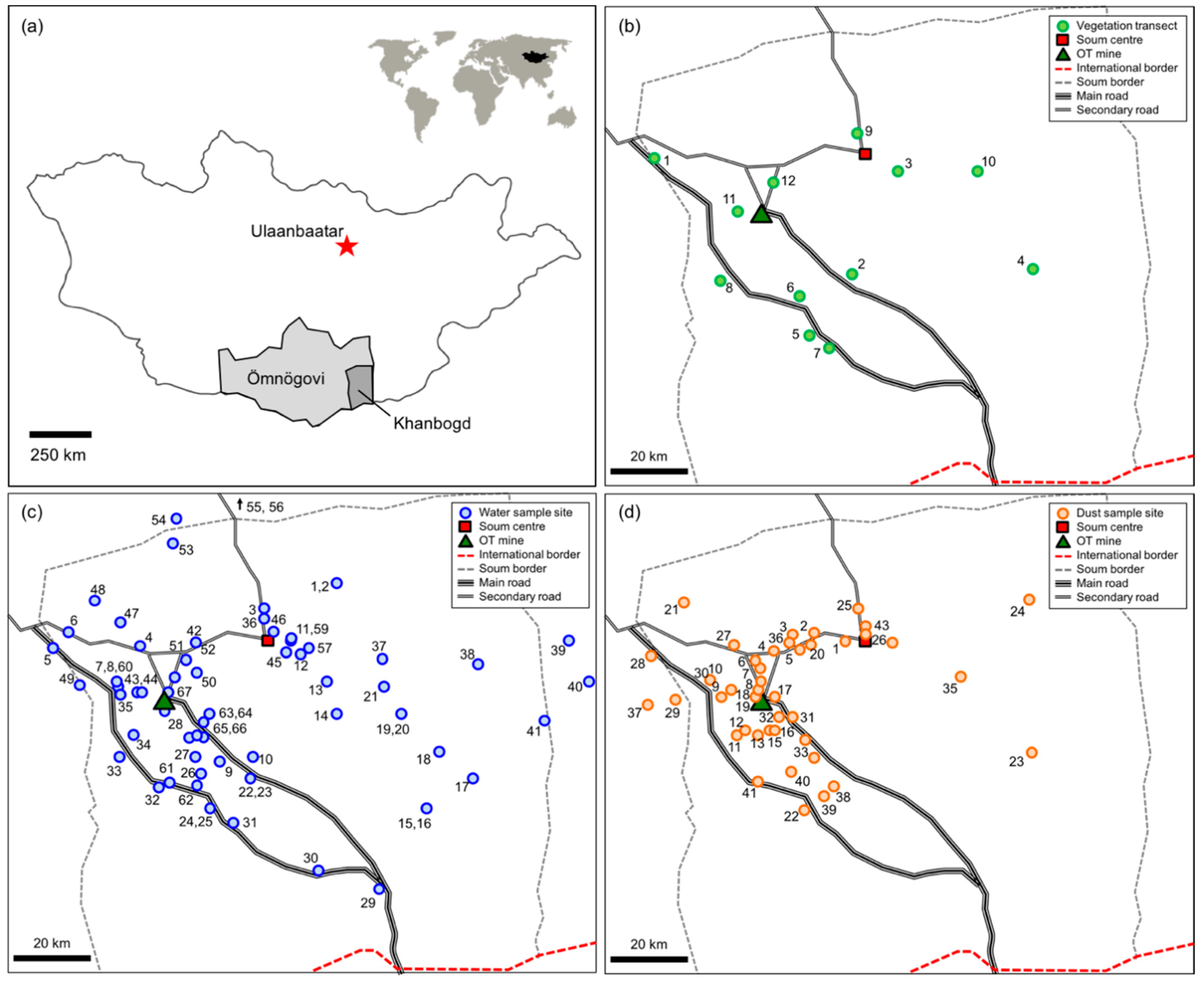
The rolling arid landscape of Khanbogd soum (Figure 1a), where this study is focused, is situated at an altitude of 900–1300 m in the Gobi Desert, the world’s coldest desert. The Mongolian word soum refers to the administrative district (>13,000 km2), while the soum centre refers to the only town (population > 3000; 43.20° N, 107.19° E). Khanbogd is a traditional camel breeding region, and has seen a dramatic rise in population in recent decades, with the number of households in the soum increasing more than threefold between 2003 and 2018 (see Figure S1 in the supplementary Information).
Extreme temperature variability and climatic change characterises the soum (and the Gobi Desert more widely). Khanbogd is the warmest soum in the country, with an average annual temperature of 7–8 °C, but temperatures can vary by up to 70 °C across the year [35,37]. Precipitation averages 95.3 mm per year (see Figure S1 in the Supplementary Information). Conditions in Khanbogd are similar to climate trends across the country, with the soum experiencing a 40-year warming trend and a slight increase in annual precipitation (see Figure S2 in the Supplementary Information). Negative precipitation anomalies suggested drought episodes in the 1960s, 1980s and early 2000s (see Figure S3 in the Supplementary Information).
Khanbogd soum is centred on one of the world’s largest (at 15002 km) alkali granite massifs which is part of a sedimentary and volcanic landscape radiating from the caldera into the vast steppe [38]. The surrounding desert is characterised by a dry, gravel and rock-strewn landscape with poor soils. Water is scarce in the region, with only the Bor Ovoo spring (now desiccated by mining activity) identified as a surface source. Yet shallow aquifers are present at ≥2 m depth, particularly in dry river beds, and deep aquifers of up to several hundred metres are known to exist. The landscape hosts wildlife such as wild ass, saiga antelope and the rare Gobi bear, but livestock dominates, particularly cashmere goats and camels.
Other recent infrastructure unrelated to the OT mine, including the China-bound export road of Tavan Tolgoi (one of the world’s largest coal mines), the unfinished Tavan Tolgoi railroad and a Qatari bird and wildlife reserve (an extensive fenced exclusion zone east of the soum centre) have contributed to land fragmentation and loss of pasture in the soum.
2.2. Data Collection
Our interdisciplinary research took place as part of an independent expert research project within the International Finance Corporation’s Compliance Advisor Ombudsman (CAO) complaint resolution process in 2016, and follow-up qualitative research was conducted in 2019. Key themes in the herder complaint lodged to the CAO [39] included mining impact on water supply, pasture degradation and resultant dust impacts upon human and livestock health. In addition, herders identified concerns regarding the ability to practice traditional livelihoods, thus another aspect of the study was focused on understanding the socio-economic dynamics and changes in land use since 2003.
2.2.1. Pasture
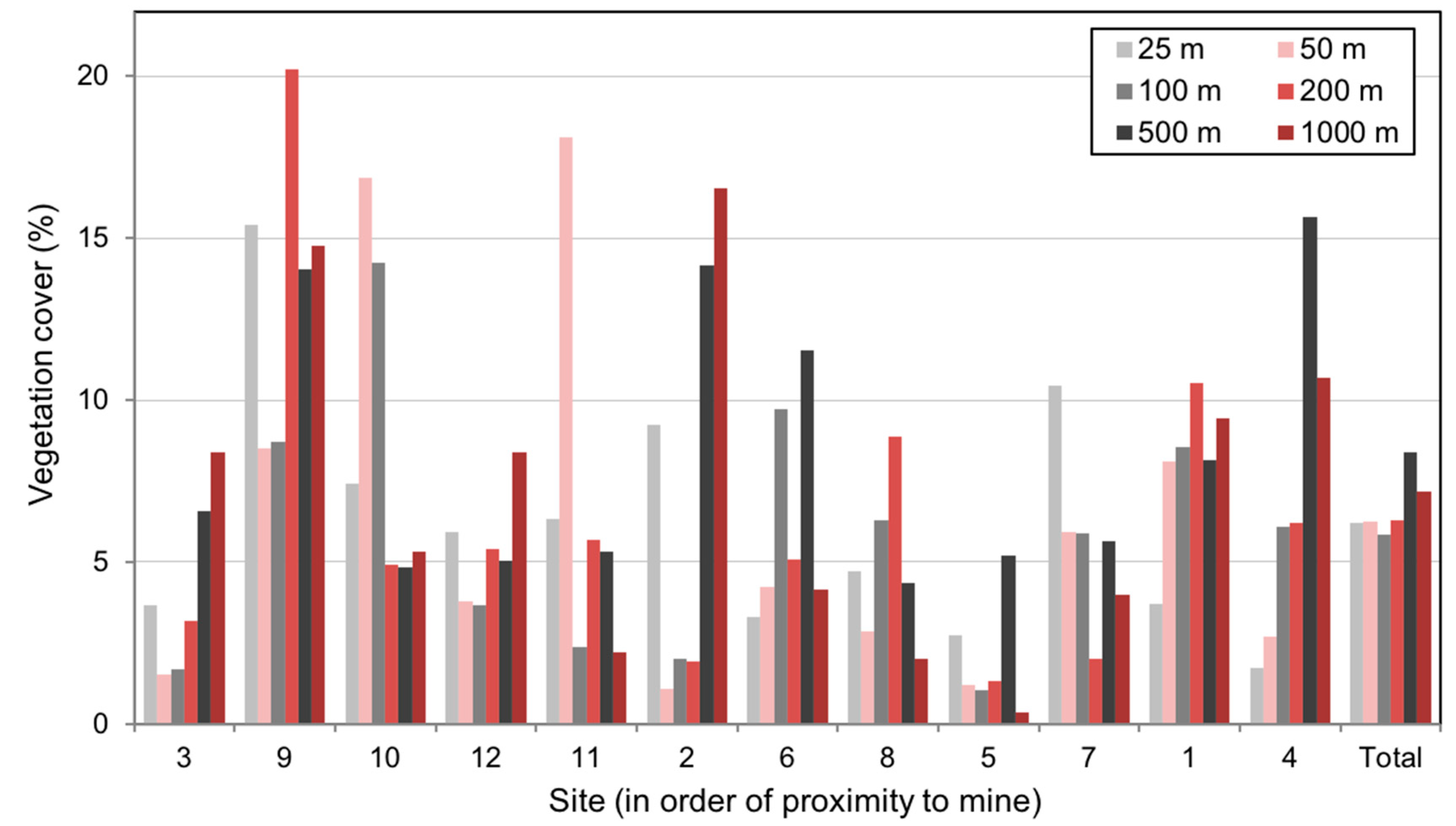
Vegetation cover was examined using twelve 1 km vegetation transects located at or near water sources, which themselves were selected to be co-located with herder households and key points of interest relating to the mine. We chose the twelve vegetation transect sites to cover as large an area as possible across the soum, and at various distances from the mine itself (Figure 1b).
For each transect, vegetation measurements were taken at 25 m, 50 m, 100 m, 200 m, 500 m and 1000 m from the water source to identify cover as a function of distance from a well. At each distance, a 50 m section of pasture was examined [40]. Percentage of plant basal cover for each meter along the line was recorded as a measure of plant density. At each site, plant species growing along the transect were collected to establish species composition and animal palatability (see Table A1). It should be noted that May–July 2016 was a particularly rainy period, including several days in May and June when fieldwork was conducted. This would be expected to lead to greater cover than drier years.
2.2.2. Access to Water
To evaluate water resources available to herder livelihoods, we examined the distribution, quality and access to water sources at 67 locations across the soum (Figure 1c). As explained above, the water source field sites were selected based on their collocation with herder households and key points of interest relating to the mine.
Water quality was assessed at all sites by measuring the pH, total dissolved solids (TDS) and electrical conductivity (EC) using a Hanna HI meter (model 98129), which provides an approximate indication of relative water quality in the field. Sensafe strips were also used to test for heavy metals at each site. Depth was documented by lower rope that was then tape-measured for distance.
2.2.3. Dust
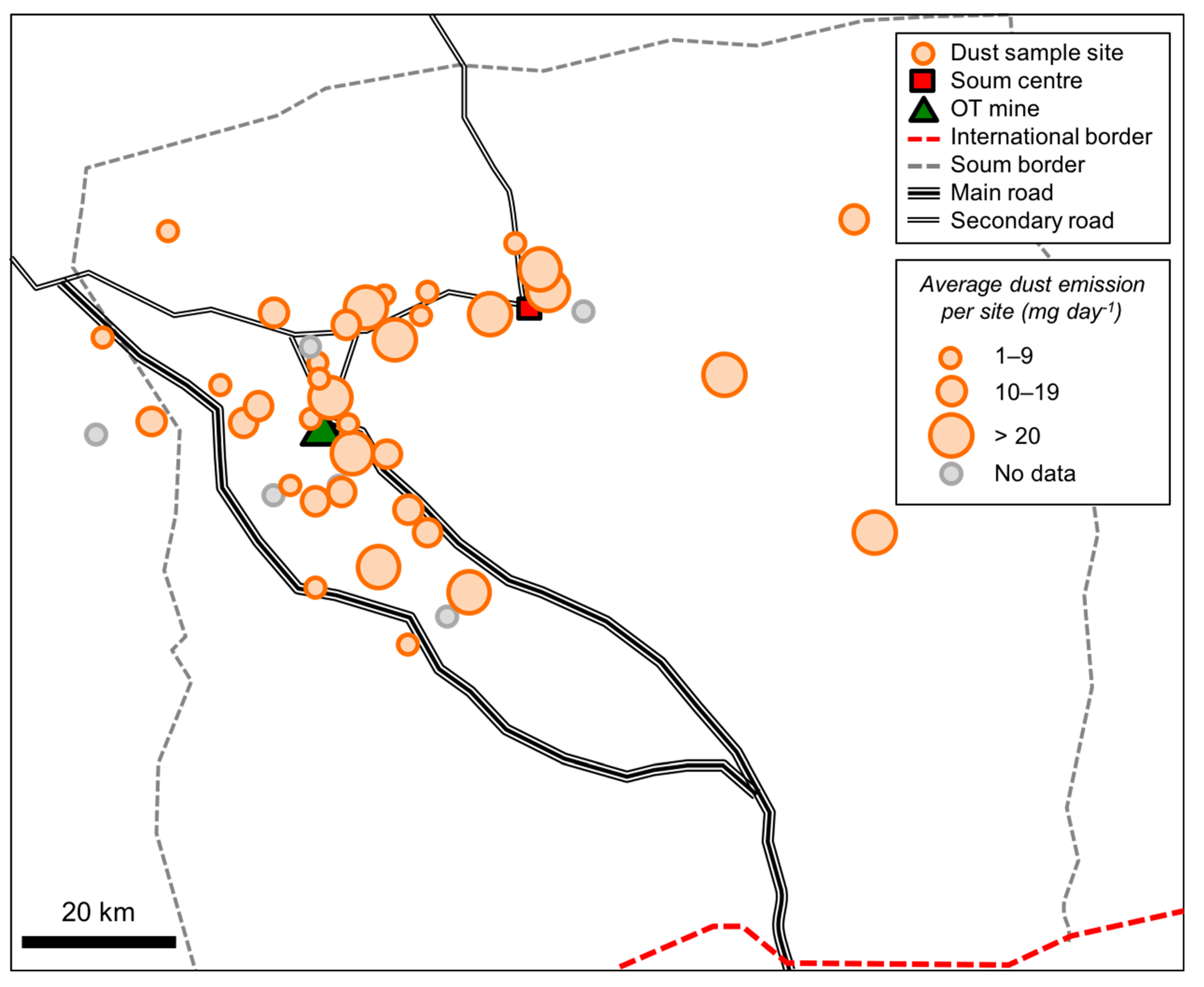
Dust impact was monitored by placing 43 dust traps (composed of a simple cardboard structure holding an absorptive sponge (100 × 60 × 30 mm) throughout the soum during May 2016 (Figure 1d). Dust traps were placed in areas covering both the 20 km “exclusion zone” around OT, as well as sites further from the mine itself, including along major roads, at herder camps, bagh centres, water sources and in the soum centre. Placement included sites deemed most relevant to the herder community, such as along roads and near gers (mobile tent homes).
Due to significant logistical difficulties, including long distances, the absence of roads and constrained research schedules, traps were placed and collected on different dates, but all traps remained in situ for 1–2 weeks. As noted above, the unusual occurrence of rain during the fieldwork period may have potentially impacted dust collection and retention at different sites.
Given the construction of the dust traps and the timings of their distribution, we consider the dust trap data to be valuable as a relative measure of dust deposition between samples, rather than an absolute measure that could be directly compared to other methodologies. While fairly simplistic, our methodology does allow us to identify broader-scale spatial patterns of dust emission across the study period.
In support of our dust trap data, we extracted aerosol optical depth (AOD) measures for the study region from remotely sensed MODIS imagery [41]. We downloaded publicly available data from the NASA MOD-4 Aerosol Product [42] over the years 2002–2016 to establish a historical dust record for Khanbogd soum. This dataset provided additional contextual information to support findings from the more granular dust trap data.
2.2.4. Interviews and Focus Groups
We assessed herder perceptions and land use practices by conducting 106 interviews with herder households registered across four baghs in Khanbogd soum. The households were randomly selected from a list provided by the local government of herder households registered in the soum. Interviews were conducted in herders’ ger homes, outdoors and in community centres at times and places convenient for herders. This enabled us to speak with herder households across the territory, including households who had been resettled from the Oyu Tolgoi license area and others who lived more than 100 km from the mine site. Ariell Ahearn and Tsendsuren Purevsuren conducted all of the interviews together in the Mongolian language. A set question list was used with herders in a semi-structured approach. Additionally, a select number of Oyu Tolgoi and local government representatives were interviewed. A diversity of herder experiences were captured, but only the major trends are noted in Section 3.2 on socio-economic dynamics.
Seven focus groups were also conducted as part of the wider CAO complaint resolution process. Participants included mine staff/representatives, local government officials and herders and participant observation. In 2018–2019, an additional 98 follow-up interviews were conducted in order to develop a preliminary set of longitudinal data. All interviews were transcribed into the Mongolian language and translated into English, and coded using NVivo software.
3. Results
3.1. Environmental Dynamics
3.1.1. Pasture
Transect data revealed there was at least some vegetation cover across the 12 soum sites (Figure 2). Average coverage at each site ranged from 2.0% (site 5, south of the Tavan Tolgoi road) to 13.6% (site 9, north of the soum centre). In general, vegetation cover was relatively homogenous in the zone 25–200 m from each water source (varying from 5.9 to 6.3%), and tended to increase slightly with increased distance from the water source. This suggests that isolated water points lead to a concentration of livestock and thus higher grazing and trampling damage to plants.
The vegetation transects ranged in distance from the mine from ~5 km to ~70 km, but we found no clear relationship between the proximity of the vegetation transects to the mine and the level of vegetation cover. Transects closest to the mine (transects 11 and 12) had similar coverage to those further away (transects 3, 7 and 8), and the least vegetated transect (transect 5) was distant from the mine. Whilst our transects were not designed to provide data on volume or biomass, most of the identified plant types were found to be palatable for animals (see Appendix A). Vegetation covers reported here are relatively lower than previous assessments [43,44,45], which report average cover of 8–25% across selected sites.
3.1.2. Access to Water
In the Gobi, surface water is limited and the majority of herders rely on wells for their water supply. Examinations of 67 water sources across the soum showed that, of all the surveyed sites, 46 sources (69%) were shallow hand wells, 14 sources (21%) were motorised deep wells, 5 sources (7%) were surface sources, and 2 sources (3%) consisted of water delivered by Oyu Tolgoi (Appendix B). Of the hand wells that were surveyed, almost 80% had water depths shallower than 2 m below ground level (Table 1), and of the surveyed deep wells, 85% were locked and only accessible by key. Locked wells are highly unusual in Mongolia; typically, water is openly available to anyone in the region and well maintenance is the responsibility of local governments (Jackson 2018).
The impact of mining on the drawdown of surface level water and shallow groundwater was not ascertainable, as water levels suggest well viability. The absence of well baseline data at mining initiation prevented comparison over time.
The majority of surveyed water sources were of good to satisfactory quality, in terms of pH ( = 8.2), TDS ( = 583 mg L−1) and EC ( = 1149 μS cm−1) (see Figure S3 in the Supplementary Information for detailed site-specific data). All sites had relatively low heavy metal presence (<20 g L−1). Seven sites had particularly high (>1000 mg L−1) TDS levels, and three sites near Khanbogd town had relatively high (>9.0) pH levels.
3.1.3. Dust
The levels of dust measured using the dust traps in May 2016 varied significantly across the soum (Figure 3). The highest levels were observed at two sites on the Khanbogd road, yet other sites on the same road recorded up to 85% fewer dust particles. High amounts of dust were also recorded in the soum centre and at an isolated site near a powerline. Several sites related to mining construction and operation were examined; in fact, the old OT airport, paved sections of road and areas 250 m off the unpaved Khanbogd road had the lowest dust concentrations, suggesting that traffic on the unpaved road had a limited impact on dust beyond its immediate vicinity. In general, it was found that variables such as wind, weather conditions and environment were more relevant to measured dust volume than proximity to potential spot locations for dust emissions, such as the OT mine, the old airport, the paved road or herder camps.
In general, dust was more prevalent at our sites in Nomgon bagh than in Javalant or Gavaluut baghs (which are closest to the mine). Driving tracks were as much as 75 m wide in Javalant bagh and 55 m wide in Bayan bagh as vehicles choose alternate tracks depending on conditions. In the absence of paved roads, traffic creates multiple “braided” tracks across the landscape. In comparison, the (then unpaved) OT-Khanbogd road is 11 m wide with 2–4 m soft edges. Heavy truck traffic on the road to China (particularly coal transport) on dirt tracks, creation of new tracks and digging up of riverbeds for local construction material can instigate erosional processes and provide source material for dust transport. Our methods do not allow the initial source of the dust to be ascertained, but it is likely that several other potential dust sources exist beyond mining and road traffic: quarries and dirt pits, construction of a railway and new powerline, dry riverbeds and areas of livestock concentration. Moreover, large-scale dust events also occur, which can have landscape-wide impacts. An example during our field season is that the local Khanbumbat airport was temporarily closed due to dust storms on 22 May 2016.
Results from the aerosol optical depth (AOD) analysis (Figure 4) show high variability in dust presence throughout the 2000s. This may be associated with mine site development and transport from Tavan Tolgoi on unpaved roads. High dust levels were observed in the soum from 2005 to 2010 (= 0.22, = 0.11), which may be linked to operational developments at OT, and this was followed by a steep decline after the autumn of 2010 (= 0.17, = 0.06). There is significant intra-annual variability resulting from local wind patterns and strengths, with higher dust levels occurring in spring (MMA, = 0.28, = 0.07) and lower levels in autumn (SON, = 0.13, = 0.03). On NASA’s scale of 0.1 being very clear and 0.4 being very dusty [42], dust levels in the past few years have largely remained at satisfactory levels, though levels reach higher in late 2015. Whilst evaluating the impact of specific dust sources on human health was beyond the scope of the investigation, it is in any case difficult to assess “additionality” to dust-based illnesses since residents of arid environments often grow up in dusty conditions [46].
3.2. Socio-Economic Dynamics
Several factors were identified that affected herding in Khanbogd from 2003 to 2016, some of which are common features of social change in rural Mongolia. The market system, including financialisation of education, veterinary services and health care, has increased herder household reliance on short-term bank loans [18]. New patterns of herder household organisation reflect changing socio-economic conditions. As an example, lowered school enrolment age and the need to provide childcare to children attending school in town initiates household splitting practices that reduce children’s opportunities to learn herding skills at a young age. Herders often identify, as a major change in herding practice, the use of new technology such as motorcycles and cars to herd livestock, which contributes to higher livelihood costs. While these issues are also apparent in Khanbogd, the rapid shift (within a decade) from land use dominated by mobile pastoralist systems to one of extraction and export has had particular effects. Large-scale mining in the region and the issuance of licenses for further mineral exploration in the soum has involved loss of pasture land, displacement of households, the development of an industrial landscape and further population from migration into Khanbogd soum.
Pasture fragmentation, loss of pasture access, reduced usufruct grazing rights, dust, herder land disputes, new infrastructure and overgrazing were pressing concerns (Table 2). Such factors led to a sense of insecure land rights and unmet expectations. Local government was ineffective at resolving problems. The local government’s role in assigning winter camps, maintaining wells and resolving problems was perceived as poorly executed. The government was not trained or supported by the central government to deal with the great community transformation spurred by the mine. Herders believed the mine should resolve problems directly as the government was ineffective. State-level authorities were regarded with suspicion and thought to be interested in primarily benefitting their own private interests.
3.2.1. Resettlement and Competition for Pasture
As a result of the resettlement of herders by Ivanhoe Mines during the initial construction of Oyu Tolgoi (2004) and again during Rio Tinto’s development (2011) of a water pipeline, an airport and energy infrastructure, herders were displaced from their original territories. These mine-directed resettlement and compensation programmes compacted herder camp locations. The OT resettlement action plans recognised compensation primarily for herder winter camps which had been officially registered with the local government within a specified distance from a piece of fixed infrastructure. These so-called impact zones did not correspond to herder mobile land use practices. Officially registered spring camps located inside the impact zones were also included to some extent, but unevenly. This methodology was not able to adequately capture mobile livelihood practices, thereby excluding many herders who relied on grazing their livestock on pastures within an “impact zone” but did not have a registered winter or spring camp within the zone. This resettlement approach created confusion and resentment amongst herders who were not recognised as having legitimate land claims in this process. Nonetheless, OT has provided compensation to herders who qualify based on their definition of mine impacts based on a mediated community settlement (“An example to All”, The Guardian, 2019 [47]) and has provided temporary employment to some households as part of this scheme.
These displacements compounded competition for pasture and conflict between herders. Mobility, the key coping strategy, now encounters restricted water points and assigned winter camps that may limit options and impede migration routes as not all land in the soum is suitable or accessible for livestock grazing, or lacks sufficient water. Many herders who moved away from Oyu Tolgoi into new territories were called “sell outs” by herders present in those areas and chased away. In 2016, an elderly widow reported during an interview, “Households which lack water and pasture due to the activity of Oyu Tolgoi are pushed out. When they arrive at the new place, local people accuse them of selling off their land to outsiders and ostracize them. My children must have felt it fully when we moved to the north. Since then my children say that it is not worth moving anywhere, because everywhere we went there was pressure and gossip. I feel that it is difficult to carry that burden. When we move somewhere else we experience a lot of such pressure”.
The OT mine contributed to these livelihood pressures but was not the only source. For example, the vast Tavan Tolgoi coal mine 140 kilometres to the north constructed a road through Khanbogd soum for export. The road’s constant stream of trucks driving to the Chinese border and the roadside trench barriers have fragmented common pasture and have created obstacles for livestock to move across the landscape to reach grazing areas. A railroad development project and new industrial activities including quarries also contributed to the wider transformation in the soum. Mineral royalties, which could contribute to local improvements, go to the central government. Payments are not directed to herder issues; inadequate funding returns to the soum for investment or amelioration of extractive impacts.
3.2.2. Pressure on Resources
Key issues were over access to water, pasture and winter camps. The challenge of water availability for livestock vis a vis the amount consumed by the mine was a major complaint. Responsibility was commonly attributed to the OT mine; for example, almost all households interviewed perceived their water shortage problems as caused either entirely or partially by OT mining activities. Yet various non-mine-related social, infrastructural and physical changes have also modified herder livelihoods over time.
There has been a loss of customs and conventions related to pressures on water resources and grazing pasture driven by development of infrastructure and a transition in land use and tenure rights. For many households, lack of sufficient labour at the household level compromises the capacity to hand-milk livestock, which in turn affects the production of traditional livestock-based products.
In a notable judgement of herding viability, not all herders want their children to become herders because of perceived and experienced economic and environmental insecurity. For current and future herders, major challenges are the presence of mines and government shortcomings in planning and lack of structure that protects herders’ customary rights. Importantly, these include access to pasture and functioning water wells and the ability to continue mobile herding with migration privileges. A herder living in Javkhlant bag explained, “Although today they are building us some buildings, brought electricity and a road, they robbed us of our future. There is no pasture and water here and therefore there is no future. When the groundwater is pumped out we no longer will have pasture and all life will become strange.”
Mine impact, locked wells, the increase in livestock, slow well recharge and a lack of shallow groundwater were common issues cited with various causes (Table 3). The Bor Ovoo spring was lost to the OT mine license area; wells are slow to recharge; there is a lack of wells in areas with good vegetation; there are fewer migrating herders, who rely on wells for longer periods of time. Such changing patterns increase pressure on limited water sources.
“Long ago, we used to move a lot. The water and pasture were enough. The Bor Ovoo [spring] water was spread everywhere in all of Javkhlant bagh. We did not use a bucket [to get water], we only used the water spread on the ground”—Javkhlant bagh herder.
“If we don’t move and stay in one place, our herds will not grow. Also, the well pump is expensive too. So many expenses. In the places we move to, people sometimes have good attitude, sometimes a bad attitude. Some people let us drink their water, some won’t”—Bayan bagh herder.
Customary land tenure enables mobility across land; this is now compromised by exclusive use given to companies, rail construction and incoming industries. Herders’ rights to use land (more secure when pastoralism was the main economic practice) are subordinate to these private leases issued by government authorities. Traditional land tenure systems, protected vaguely by law, appear to be ineffective as the national and local governments issue extractive licenses. In Khanbogd, wealth is customarily measured by number of livestock with large animals (horse, camel, cattle) of greater value and cashmere goats generating cash each spring. An increase in livestock at the household or district level is the best available assessment of expanding economic activity. When the land tenure systems clash there is evidence that more wealthy households attempt to secure their rights to use pasture through additional investments such as property ownership, permanent buildings and obtaining more than one winter and spring camp site. One household (with 991 livestock) reported having three winter camps and two spring camps. More than 90% of herders report that climate (i.e., weather, amount of precipitation) and infrastructure (mining-related infrastructure, the presence of other household camps) are the primary impacts on pasture availability.
3.2.3. Herders Remain Semi-Nomadic
Findings stressed that Khanbogd soum herders remain semi-nomadic, moving to varying degrees from camp to camp (Table 4). The OT mine land take, though severe (mine license area is 80 km2), accounts for a small proportion of soum pasture land. In principle, with government organisation, it is possible for herding to continue despite the mine’s presence. The failure of mining operators to collect baseline data from the project initiation meant that water impact cannot be sufficiently addressed or quantified. It was recognised that the increase in the number of livestock and changing practices affected pasture viability. Herders expressed anger and frustration about the changes that have affected their lives and communities due to the mega-mine and other processes. A sense of powerlessness in influencing the transformation was conveyed, especially by elder residents. These psychological impacts are evidenced in the feelings of an older herder, who explained, “But recently my mind is not at peace. Whenever I go out and have a look or herd my animals there is dust everywhere and trucks drive past. Then I am not able to see my animals in the dust. Nobody will be happy about that and I get frustrated about it. I have no faith in the future and worry what will happen. Considering what is happening to the water now, once the factory [OT] starts to use water more, then I think we will be badly affected. That’s why psychologically we are under great pressure. I was thinking of turning my children into herders and they will rear livestock and carry on this heritage. I don’t know what will happen. I have almost nothing left to hope for.”
3.2.4. Changing Herding Practices
Herding practices have changed in the district since 2002. Herders are moving less, with several active pastoralists (17%) now living in a fixed dwelling located at a seasonal camp (Table 5). There are growing wealth inequalities, more family separations take place and debt is widespread. Often loans are for vehicles that are expensive to buy and run. Herders cited petrol as a major expense, with estimates of 50 litres used per week. Some of these shifts are due to the presence of the mine; others reflect patterns common across the country, including changes in herder preferences and choices. Other recent developments in the district, including the coal road, the railway, small-scale mining and the fenced Qatari Wildlife Reserve, fragment pasture and affect mobility. Some herders are prospering and finding new opportunities for employment and business. Yet many are struggling. There was no clear pattern that linked success or problems systematically with the mine. However, herders attributed most of their problems to the mine.
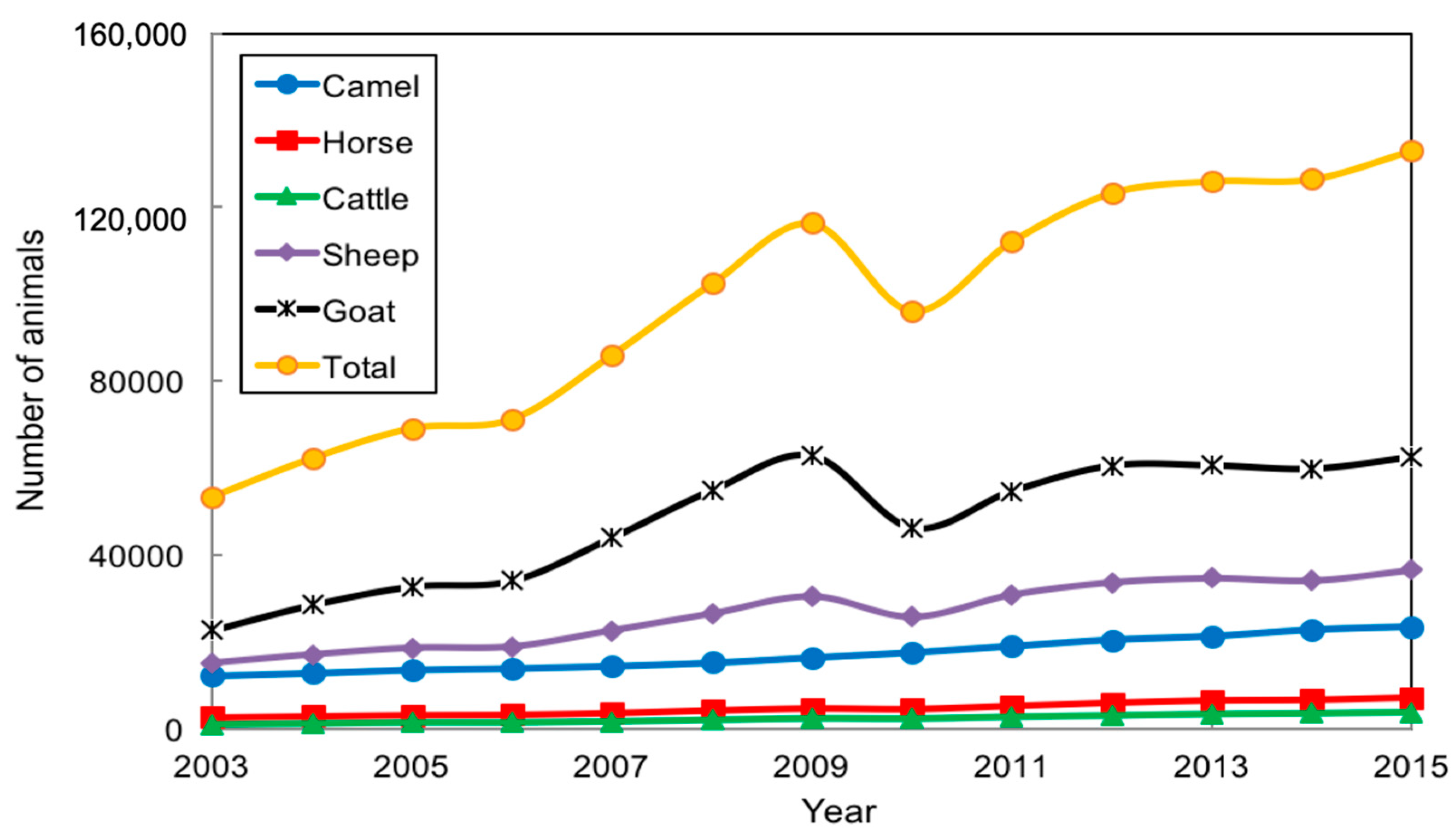
In aggregate, livestock numbers of Khanbogd herders have increased threefold from 2003 to 2015 (Figure 5). As noted, in Mongolia, livestock are a key measure of wealth. However, an aggregate count conceals a more significant change regarding wealth inequality in the region. In 2010, the livestock census in Khanbogd indicated that 6 households out of 647 each own more than 800 livestock. These 6 households owned 5.92% of the total number of livestock. By 2015, the number increased to 15 (11.37% of the total number of livestock) and by 2018 the number of households with more than 800 livestock increased to 41 households (25% of the total number of livestock). These numbers present an interesting picture, as they demonstrate a growing number of families with significant livestock holdings in Khanbogd. In 2018, two families had over 1500 head of livestock. Calculating wealth profiles for pastoralists is complex and there is increasing attention to qualitative measures, including self-reports of wellbeing, as potential avenues to capture changing dynamics [48].
The impact of OT varied with potentially negative and positive outcomes. The mine created work opportunities for some residents through full- and part-time work. Whilst locals had limited specialist skills, some had local jobs in construction, cleaning, food service, maintenance and driving.
4. Discussion
4.1. The Social and Physical Environment
Effective integration of environmental data with herder perspectives presents a strong narrative of mining impact on the Gobi pastoral environment. Herder social-ecological reports and ground truthing are consistent on several points. Many interview statements were supported by testing and observation. Yet different data collection techniques between interviews and physical investigation provide data that may at times not be comparable. Here, findings may corroborate comments or add complexity and understanding to vital issues. What develops is an in-depth account of the pastoral landscape in Khanbogd soum from two distinct methodologies. Results manifest the practical, perceptual and physical challenges in Khanbogd soum’s pastoral landscape. These shape the viability and vulnerability of herding that confronts and co-exists with mega-mining.
Interviews reveal a changing environment and demanding physical parameters that are integral to herding; environmental investigation provides physical data on the topics (Table 6). Some key points are comparable across methods—vegetation cover, fragmentation, locked wells. Other issues are complimentary, for example, an identified problem (water) and resolution (high potential for shallow wells), yet government or private funding and initiative are needed to resolve the issue. Findings highlight shared knowledge perceptions and data documentation on pasture and water. There are also differences; dust was perceived more negatively than testing presented. The concurrence on soum environmental issues builds a platform for the local government, mine and residents to understand the environment and potentially mitigate detrimental practices and ameliorate pastoral conditions.
4.2. Deserting Herding in the Gobi?
The presence of mining operations, particularly the vast OT and Tayan Tolgoi mines, is a central point of conflict for the herders of Khanbogd soum [36]. Their significant implications for the physical environment and livelihoods have raised the question, “can herding survive mining?” in Mongolia [10]. Our study shows that in 2016, mega-mining and herding did co-exist in the region, that environmental conditions were a result of diverse causes with mining being significant, and that resource extraction represented a rapid transformation of the pastoral landscape. This has potential beneficial, mixed or detrimental impacts in Khanbogd. We find that climate and natural forces, mining activities, herder behaviour and the decisions and (in)actions of the government combine to define the social-ecological systems in the soum.
Some environmental changes, such as lower water levels and sparse vegetation, could prima facie be related to mining. Key drivers of physical changes, such as climate and pasture resources, are not directly attributable to the mine. The data results and spatial variability across our study sites for dust, water and vegetation identified impacts but not an exclusive link between mining operations and environmental impact across the soum in 2016. Conditions may have been different during the construction of the mine (disruptive impact of construction); herding adjustments may have mitigated detrimental effects to water sources and pasture and mine-sponsored compensation may have satisfied some herder complaints. Less tangible forms of damage to customary rangelands, livelihood stress and new uncertainty may reflect impacts from OT; these are distinct from environmental factors. The clear, consistent responses of the herders highlight the tensions that the mine has provoked in terms of their decision-making and perceptions of environmental potential for livestock raising.
Our findings on water access in the soum (see Table 1) highlight three key issues. First, the main source for water was shallow hand wells. Second, access to existing water has been reduced through physical (locked wells) or social (herder winter camp delineation; need for permission) means of control. Third, the use of motorised pumps is changing the way that water is accessed by herders. A customary assessment of well water—how long the well takes to refill—is no longer a suitable measurement when using motorised pumps and may skew herder perceptions of water abundance/scarcity over time. There is also a potentially significant problem that surrounds the possible connection between shallow and deep aquifers resulting from boreholes drilled on behalf of OT. This was repeatedly mentioned in interviews and in public documents [49,50]. Yet the question of deep borehole construction quality and potential surface-to-deep aquifer leakage would require further examination that is beyond this investigation.
Whilst the OT mine has had direct environmental impacts, including built infrastructure (airport, roads) and loss of pasture and fragmentation, herder behaviour and societal change (development, increase in livestock and vehicles) has also affected pasture and water demand and resources. These pressures are exacerbated by poor maintenance of wells by the local authorities, and efforts by some herders to control resources through locked water points and winter camp registration, a form of implied tenure rights. Nevertheless, the overall increase in animal numbers suggests that herding has so far remained viable in the soum.
The Gobi context presented evokes Franks et al.’s (2014) [51] mining–community conflict rubric about large-scale actors’ role in socio-ecological system (SES) change. Without OT, Khanbogd soum would be similar to other Mongolian regions; part of the influence of the mega-mine has been to reconfigure basic conceptions of herding practice and sustainability. As Horrocks-Taylor (2018) [52] points out, in Kyrgyzstan, mining’s apparent economic benefits come at a risk to environments and livelihoods. In addition to detrimental mining effects (fragmentation, land take), potential overgrazing, increased livestock density and intensification (e.g., at water points) present significant pasture pressures. The situation in Mongolia maps on to Fernandez-Gimenez et al.’s [53] ecological and cultural resilience trajectories for the country. Whilst cyclical, Khanbogd soum shows OT herders occupying shared territory, something of an achievement in such a contentious space. This is in part due to the herder’s IFC complaint and OT’s resultant engagement [17,49]. Ostrom (2009) [54] would insist on focused monitoring and enforcement for SES value. In fact, the gradual herder–OT–government tripartite engagement offers hope for SES amelioration, or at least continued viability [32].
Recognising social complexity, minimising environmental risk, reducing infrastructure conflict and costs (to USD 20 million/week) exemplified in Khanbogd are challenges across mineral-rich regions [31]. In acknowledging an asymmetrical conflict [29] and engaging with the community—albeit later than desirable—Mongolian society has been able to take value from customary practices notwithstanding OT’s presence. This is timely as China’s Belt and Road Initiative, mimicked by the Mongolian Economic Corridor, comes to the greater steppe region [55]. Power imbalances, weak state governance, poor environmental standards and a lack of transparency suggest planned mining expansion in Mongolia will present a great challenge for herders and the country to cope with, manage and address. Attention to cumulative impacts of mining and related infrastructure in policy-making and directed development of supporting industry would aid in social and environmental safeguarding. Strengthening local government capacity to manage and monitor development and facilitate citizen participation in decision-making remains a crucial issue that could be addressed with additional personnel and resources.
Interactions between the herders of Khanbogd Soum and their environment is changing rapidly and will face increasing pressure in the coming decades. The continuing evolution of herding away from a subsistence livelihood adds new layers of decision-making and complexity that lead Mongolian pastoralism into an uncharted future. As socio-economic forces predominate and mining expands, the environment becomes an input rather than the defining feature. In Khanbogd Soum, physical limitations of water and pasture productivity are recognised by data and herders. These have major ramifications for the future of herding, especially if animal numbers continue to increase or extractive footprints expand. A point may soon come where traditional mobile pastoralism in the Gobi gives way to more settled livestock raising. This new reality would make the Gobi environment unrecognisable to Marco Polo, von Humboldt and, indeed, the authors of this paper.
5. Conclusions
Khanbogd soum’s location in an arid desert environment forms an important backdrop to herding activities in the area. Precipitation throughout the year is low and displays significant interannual variability. Customary herding is based on adaptation to such a harsh landscape, and resource extraction adds a new layer of complexity. The presence of the vast OT mine is a central point of conflict for the herders of Khanbogd soum. Mining-related exclusion zones and infrastructure have impacted, displaced or inconvenienced herders, and road traffic poses a risk to animals over large distances. Dust production from mining activities appears to have relatively limited impact, but unresolved water access issues continue, particularly regarding the potential connectivity between shallow and deep aquifers resulting from borehole construction. This remains a justified fear to local herders and represents an ongoing conflict with the OT mine. Looking to the future, OT’s environmental impact (i.e., water, vegetation, dust, fragmentation) identifies mega-mining outcomes at multiple levels—for the community, investors, researchers and development trajectories.
Concurrently, the perceptions, decision-making and behaviour of herders have transformed pastoralism in the soum from a subsistence livelihood into an economic activity. This has led to changes in practice, land use, motivation and conception, whilst the community participates in the domestic development trajectory. The doubling of livestock numbers whilst the OT mine has been operating documents that, contrary to common narratives, mining and herding do coexist in Khanbogd soum. Pastoral praxis and performance have transitioned; in doing so, the herding environment has been reconfigured into a workable contemporary representation, home to both pastoralism and mining. Herding has not been deserted in the Gobi.
Supplementary Materials
The following supporting information can be downloaded at: https://www.mdpi.com/article/10.3390/land11060799/s1. Figure S1. Number of households in Khanbogd Soum, from 2003–2018. Source: Mongolia National Statistics Office (2019). Figure S2. (a) Annual precipitation (mm) and average annual temperature (oC) in Khanbogd soum, 1976–2015. Dashed lines show linear trend fits; (b) Drought index for Khanbogd soum, using a 24-month average centred on the month of August. Dashed red line shows definable limit for a drought. Figure S3. Summer (May-August) precipitation levels and precipitation anomalies (i.e., yearly precipitation minus period average) for specific baghs in Khanbogd soum, 1960–2015.
Author Contributions
Conceptualization, T.S.; Formal analysis, T.S., J.R.M. and A.A.; Funding acquisition, T.S. and A.A.; Investigation, T.S., J.R.M. and A.A.; Methodology, T.S. and A.A.; Visualization, J.R.M.; Writing—original draft, T.S., J.R.M. and A.A. All authors have read and agreed to the published version of the manuscript.
Funding
This research received no external funding.
Institutional Review Board Statement
The study was conducted in accordance with the Declaration of Helsinki.
Informed Consent Statement
Informed consent was obtained from all subjects involved in the study.
Data Availability Statement
The physical data presented in this study are available in supplementary material here. The interview data are not publicly available due to privacy issues.
Acknowledgments
Authors would like to thank key researchers Tsesu Purevsuren, Batbuyan Batjav and Jill Shankleman for their contributions. The ESRC-GCRF ‘Gobi Framework’ Inclusive Societies project and the ESRC-JSPS ‘Comparative research on pastoral societies in post-Covid19 Inner Asian countries: case study of Mongolia and Kyrgyzstan’ project provided time and encouragement for the research and writing. The School of Geography, University of Oxford and the Centre for International Studies, ISCTE-University Institute Lisbon were instrumental in completing the paper. The shared knowledge and time of numerous pastoralists and residents were essential to this article.
Conflicts of Interest
The authors declare no conflict of interest.
Appendix A

Table A1.
Vegetation composition at all transects.
| Site | Latin Name | Mongolian Name | Palatability | Life Form | Growth | |
|---|---|---|---|---|---|---|
| Khanbogd 1 | Peganum nigellastrum | palatable | camel, goat, horse, sheep | perennial | forb | |
| Khanbogd 1 | Oxytropis myriophylla | palatable | camel, goat, horse, sheep | perennial | shrub | |
| Khanbogd 1 | Cleistogenes squarrosa | palatable | camel, goat, horse, sheep | |||
| Khanbogd 1 | Achnatherum splendens | palatable | camel, goat, horse, sheep | |||
| Sandaal | ||||||
| Sarmar | ||||||
| Khanbogd 2 | Ptilotrichum canescens | palatable | goat, horse | perennial | forb | |
| Khanbogd 2 | Peganum nigellastrum | palatable | camel, goat, horse, sheep | perennial | forb | |
| Khanbogd 2 | Zygophyllum xanthoxylon | palatable | camel, goat, sheep | shrub | ||
| Khanbogd 2 | Amygdalus pedunculata | palatable | camel, deer, goat, sheep | shrub | ||
| Khanbogd 2 | Lespedeza dahurica | palatable | cattle, goat, horse, sheep | perennial | forb | |
| Khanbogd 3 | Cleistogenes squarrosa | palatable | camel, goat, horse, sheep | |||
| Khanbogd 3 | Oxytropis myriophylla | palatable | camel, goat, horse, sheep | perennial | shrub | |
| Khanbogd 3 | Dracocephalum foetidum | |||||
| Khanbogd 3 | Artemisia santolinifolia | palatable | camel, cattle, goat, horse, sheep | perennial | shrub | |
| Khanbogd 4 | Iris bungei | palatable | camel, cattle, goat, horse, sheep | perennial | forb | |
| Khanbogd 4 | Oxytropis aciphylla | palatable | camel, goat, horse, sheep | perennial | shrub | |
| Khanbogd 4 | Peganum nigellastrum | palatable | camel, goat, horse, sheep | perennial | forb | |
| Khanbogd 4 | Echinops gmelinii | palatable | camel, horse | perennial | forb | |
| Khanbogd 4 | Artemisa anethifolia | palatable | camel, goat, sheep | annual/biennial | forb | |
| Khanbogd 4 | Nitraria sibirica | palatable | camel, goat, sheep | shrub | ||
| Khanbogd 4 | Convolvulus ammanii | palatable | goat, sheep | perennial | forb | |
| Khanbogd 5 | Iris oxypetala | palatable | perennial | |||
| Khanbogd 5 | Artemisia santolinifolia | palatable | camel, cattle, goat, horse, sheep | perennial | shrub | |
| Khanbogd 5 | Peganum nigellastrum | palatable | camel, goat, horse, sheep | perennial | forb | |
| Khanbogd 5 | Pedicularis abrotaniflolia | palatable | camel, goat, horse, sheep | |||
| Khanbogd 5 | Achnatherum splendens | palatable | camel, goat, horse, sheep | |||
| Khanbogd 5 | Sandaal | |||||
| Khanbogd 5 | Sarmar | |||||
| Khanbogd 6 | Iris bungei | palatable | camel, cattle, goat, horse, sheep | perennial | forb | |
| Khanbogd 6 | Arnebia guttata | palatable | camel, goat, sheep | perennial | forb | |
| Khanbogd 6 | Ptilagrostis pelliotii | perennial | ||||
| Khanbogd 6 | Stipa gobica | palatable | camel, cattle, goat, horse, sheep | grass | ||
| Khanbogd 6 | Raemuria soongorica | palatable | camel, goat, sheep | perennial | shrub | |
| Khanbogd 6 | Tournefortia sibirica | palatable | camel | perennial | forb | |
| Khanbogd 6 | Artemisia santolinifolia | palatable | camel, cattle, goat, horse, sheep | perennial | shrub | |
| Khanbogd 6 | Iris oxypetala | palatable | perennial | |||
| Khanbogd 6 | Amygdalus pedunculata | palatable | camel, deer, goat, sheep | shrub | ||
| Khanbogd 6 | Kalidium foliatum | palatable | camel | shrub | ||
| Khanbogd 6 | Olgeae leucophylla | perennial | forb | |||
| Khanbogd 6 | Zygophyllum rosovii | palatable | cattle, goat, horse, sheep | perennial | shrub | |
| Khanbogd 6 | Scorphularia incisa | shrub | ||||
| Khanbogd 6 | Artemisia scoparia | palatable | camel, cattle, goat, horse, sheep | biennial | forb | |
| Khanbogd 6 | Zygophyllum xanthoxylon | palatable | camel, goat, sheep | shrub | ||
| Khanbogd 7 | Raemuria soongorica | palatable | camel, goat, sheep | perennial | shrub | |
| Khanbogd 7 | Peganum nigellastrum | palatable | camel, goat, horse, sheep | perennial | forb | |
| Khanbogd 7 | lom | palatable | camel, goat, horse, sheep | shrub | ||
| Khanbogd 7 | Artemisia scoparia | palatable | camel, cattle, goat, horse, sheep | biennial | forb | |
| Khanbogd 7 | Nitraria sibirica | palatable | camel, goat, sheep | shrub | ||
| Khanbogd 7 | Oxytropis aciphylla | palatable | camel, goat, horse, sheep | perennial | shrub | |
| Khanbogd 8 | Elymus paboanus | palatable | camel, cattle, goat, horse | grass | ||
| Khanbogd 8 | Amygdalus pedunculata | palatable | camel, deer, goat, sheep | shrub | ||
| Khanbogd 8 | Stipa gobica | palatable | camel, cattle, goat, horse, sheep | grass | ||
| Khanbogd 8 | Convolvulus ammanii | palatable | goat, sheep | perennial | forb | |
| Khanbogd 8 | Salsola passerina | palatable | camel, goat, horse, sheep | shrub | ||
| Khanbogd 8 | Raemuria soongorica | palatable | camel, goat, sheep | perennial | shrub | |
| Khanbogd 8 | Olgeae leucophylla | forb | ||||
| Khanbogd 8 | Zygophyllum xanthoxylon | palatable | camel, goat, sheep | shrub | ||
| Khanbogd 9 | Elymus chinensis | palatable | camel, cattle, goat, horse, sheep | perennial | grass | |
| Khanbogd 9 | Amygdalus pedunculata | palatable | camel, deer, goat, sheep | shrub | ||
| Khanbogd 9 | Peganum nigellastrum | palatable | camel, goat, horse, sheep | perennial | forb | |
| Khanbogd 9 | Caragana leuncophloea | palatable | camel, goat, sheep | shrub | ||
| Khanbogd 9 | Eurotia ceratoides | palatable | shrub | |||
| Khanbogd 9 | Convolvulus ammanii | palatable | goat, sheep | perennial | forb | |
| Khanbogd 9 | Arnebia guttata | palatable | camel, goat, sheep | perennial | forb | |
| Khanbogd 9 | Nitraria sibirica | palatable | camel, goat, sheep | shrub | ||
| Khanbogd 9 | Salsola passerina | palatable | camel, goat, horse, sheep | shrub | ||
| Khanbogd 9 | Oxytropis aciphylla | palatable | camel, goat, horse, sheep | perennial | shrub | |
| Khanbogd 10 | Suaeda corniculata | palatable | camel, goat, horse, sheep | annual | forb | |
| Khanbogd 10 | Elymus paboanus | palatable | camel, cattle, goat, horse | grass | ||
| Khanbogd 10 | Raemuria soongorica | palatable | camel, goat, sheep | perennial | shrub | |
| Khanbogd 10 | Peganum nigellastrum | palatable | camel, goat, horse, sheep | perennial | forb | |
| Khanbogd 10 | Ptilotrichum canescens | palatable | goat, horse | perennial | forb | |
| Khanbogd 10 | Nitraria sibirica | palatable | camel, goat, sheep | shrub | ||
| Khanbogd 10 | Convolvulus fruticosus | shrub | ||||
| Khanbogd 11 | Scorzonera pseudodivaricata | palatable | goat, sheep | shrub | ||
| Khanbogd 11 | Zygophyllum xanthoxylon | palatable | camel, goat, sheep | shrub | ||
| Khanbogd 11 | Iris bungei | palatable | camel, cattle, goat, horse, sheep | perennial | forb | |
| Khanbogd 11 | Stipa gobica | palatable | camel, cattle, goat, horse, sheep | grass | ||
| Khanbogd 11 | Panzeria lanata | palatable | goat, horse, sheep | forb | ||
| Khanbogd 11 | Peganum nigellastrum | palatable | camel, goat, horse, sheep | perennial | forb | |
| Khanbogd 11 | Raemuria soongorica | palatable | camel, goat, sheep | perennial | shrub | |
| Khanbogd 11 | Nitraria sibirica | palatable | camel, goat, sheep | shrub | ||
| Khanbogd 11 | Atriplex sibirica | annual | forb | |||
| Khanbogd 11 | Bassia dasyphylla | palatable | camel | annual | shrub | |
| Khanbogd 12 | Stipa gobica | palatable | camel, cattle, goat, horse, sheep | grass | ||
| Khanbogd 12 | Eurotia ceratoides | palatable | shrub | |||
| Khanbogd 12 | Peganum nigellastrum | palatable | camel, goat, horse, sheep | perennial | forb | |
| Khanbogd 12 | Anabasis brevifolia | palatable | camel | perennial | forb |
Appendix B
Table A2.
Water quality and well characteristics.
| Site | pH | TDS | EC | Heavy Metals (Semi-Qualitative) | Water Level (m) | Bagh | Well Type |
|---|---|---|---|---|---|---|---|
| W1 | 7.8 | 840 | 1585 | 10 | ~ | Bayan | Hand pump |
| W2 | 6.3 | 775 | 1570 | 10 | 2.4 | Bayan | Hand pump |
| W3 | 7.7 | 350 | 690 | 20 | ~ | Bayan | Deep, motor, locked |
| W4 | 7.88 | 2000 | 4000 | 10 | ~ | Gavalut | Delivery tank |
| W5 | 8.07 | 2000 | 4000 | 20 | ~ | Gavalut | Deep, motor, locked |
| W6 | 8.3 | 404 | 680 | 20 | 8 | Gavalut | Hand |
| W7 | 7.8 | 1075 | 2180 | 10 | 1 | Gavalut | Hand |
| W8 | 7.9 | 415 | 820 | 10 | ~ | Javalant | Deep, motor, locked |
| W9 | 8.2 | 307 | 616 | 20 | 1 | Javalant | Hand |
| W10 | 8 | 338 | 678 | 10 | ~ | Javalant | Hand pump |
| W11 | 9.2 | 155 | 318 | 10 | 0 | Nomgon | Surface |
| W12 | 9.2 | 277 | 530 | 10 | 9 | Nomgon | Hand |
| W13 | 8.99 | 254 | 507 | 10 | 2 | Nomgon | Hand |
| W14 | 8.8 | 520 | 1040 | 10 | ~ | Nomgon | Deep, motor, locked |
| W15 | 8.9 | 328 | 655 | 10 | 3 | Nomgon | Deep, motor, locked |
| W16 | 8.65 | 221 | 444 | 10 | ~ | Nomgon | Deep, motor |
| W17 | 8.6 | 1892 | 3785 | 10 | 6 | Nomgon | Deep, motor, locked |
| W18 | 8.5 | 744 | 1492 | 10 | ~ | Nomgon | Deep, motor |
| W19 | 8.45 | 592 | 1180 | 10 | 2 | Nomgon | Hand |
| W20 | 8.35 | 582 | 1159 | 10 | 2 | Nomgon | Hand |
| W21 | 8.6 | 362 | 722 | 10 | 1.9 | Nomgon | Hand |
| W22 | 8.38 | 673 | 1040 | 10 | 2 | Javalant | Hand |
| W23 | 8.64 | 684 | 1362 | 10 | 2 | Javalant | Hand |
| W24 | 8.84 | 519 | 1036 | 10 | 1 | Javalant | Hand |
| W25 | 8.68 | 396 | 793 | 10 | 1 | Javalant | Hand, tire well |
| W26 | 8.85 | 459 | 911 | 10 | 2 | Javalant | Hand |
| W27 | 8.62 | 340 | 664 | 10 | 2 | Javalant | Hand |
| W28 | 8.8 | 223 | 445 | 10 | 1 | Javalant | Hand |
| W29 | 8.53 | 202 | 401 | 50 | 0 | Hairan | Surface |
| W30 | 8.54 | 122 | 247 | 10 | 0 | Javalant | Surface |
| W31 | 7.9 | 1907 | 3761 | 10 | 0.5 | Javalant | Hand |
| W32 | 8.38 | 485 | 971 | 20 | 2 | Javalant | Hand |
| W33 | 8.4 | 321 | 643 | 10 | 1.5 | Javalant | Hand |
| W34 | 8.62 | 306 | 618 | 10 | 2 | Javalant | Hand |
| W35 | 8.53 | 595 | 1210 | 10 | 1 | Javalant | Hand |
| W36 | 8.38 | 315 | 631 | 20 | 1.2 | Javalant | Hand |
| W37 | 8.28 | 217 | 431 | 10 | 2 | Bayan | Hand pump |
| W38 | 8.45 | 95 | 188 | 10 | 0 | Bayan | Surface |
| W39 | 7.98 | 313 | 628 | 10 | ~ | Bayan | Deep, motor, locked |
| W40 | 7.74 | 797 | 1587 | 10 | ~ | Bayan | Hand pump |
| W41 | 8.24 | 127 | 256 | 10 | 3 | Bayan | Hand |
| W42 | 7.04 | 1003 | 1997 | 20 | 2 | Javalant | Hand |
| W43 | 7.8 | 2000 | 4000 | 20 | ~ | Gavalut | Delivery |
| W44 | 8.08 | 579 | 1230 | 10 | 1 | Gavalut | Hand |
| W45 | 8.02 | 233 | 470 | 10 | 0 | Nomgon | Surface |
| W46 | 7.7 | 178 | 356 | 10 | 2 | Javalant | Hand |
| W47 | 8.3 | 440 | 879 | 20 | 2 | Gavalut | Hand |
| W48 | 8.1 | 722 | 1441 | 20 | 11 | Gavalut | Deep, motor, locked |
| W49 | 8.2 | 892 | 1790 | 10 | 1.5 | Gavalut | Hand |
| W50 | 7.8 | 638 | 1277 | 50 | ~ | Javalant | Deep, motor, locked |
| W51 | 8.38 | 507 | 1011 | 10 | 32 | Javalant | Deep, motor, locked |
| W52 | 8.05 | 455 | 906 | 10 | ~ | Javalant | Deep, motor, locked |
| W53 | 8.12 | 362 | 7.65 | 10 | 5 | Gavalut | Hand |
| W54 | 8.06 | 540 | 1076 | 10 | 2 | Gavalut | Hand |
| W55 | 7.9 | 637 | 1275 | 20 | 75 | Bayan | Deep, motor, locked |
| W56 | 7.9 | 788 | 1571 | 20 | 2 | Bayan | Hand |
| W57 | 7.85 | 260 | 520 | 20 | 3 | Nomgon | Hand |
| W58 | 8.5 | 158 | 318 | 20 | 2 | Nomgon | Hand |
| W59 | 8.1 | 542 | 1081 | 10 | 1.5 | Nomgon | Hand |
| W60 | 8.46 | 411 | 822 | 10 | 1 | Gavalut | Hand |
| W61 | 7.51 | 664 | 1306 | 10 | 1.1 | Javalant | Hand |
| W62 | 8.09 | 586 | 1156 | 20 | 1 | Javalant | Hand |
| W63 | 8.06 | 560 | 1158 | 10 | 3.5 | Javalant | Hand |
| W64 | 7.58 | 539 | 1079 | 20 | 1.8 | Javalant | Hand |
| W65 | 7.58 | 813 | 1623 | 20 | 1.2 | Javalant | Hand |
| W66 | 7.92 | 411 | 821 | 10 | 1 | Javalant | Hand |
| W67 | 8.47 | 669 | 1340 | 10 | 1 | Javalant | Hand |
References
- Sternberg, T. Desert Boundaries: The once and future Gobi. Geogr. J. 2014, 181, 61–72. [Google Scholar] [CrossRef]
- Lazzerini, N.; Zazzo, A.; Coulon, A.; Marchina, C.; Bayarkhuu, N.; Bernard, V.; Cervel, M.; Fiorillo, D.; Joly, D.; Noûs, C.; et al. Season of death of domestic horses deposited in a ritual complex from Bronze Age Mongolia: Insights from oxygen isotope time-series in tooth enamel. J. Archaeol. Sci. Rep. 2021, 32, 102387. [Google Scholar] [CrossRef]
- Fernández-Giménez, M. Sustaining the steppes: A geographical history of pastoral land use in Mongolia. Geogr. Rev. 1999, 89, 315–342. [Google Scholar] [CrossRef]
- Ahearn, A. Herders and hazards: Covariate dzud risk and the cost of risk management strategies in a Mongolian subdistrict. Nat. Hazards 2018, 92, 165–181. [Google Scholar] [CrossRef] [Green Version]
- Mayaud, J.; Sternberg, T. Mongolian Mining Boom Threatens Traditional Herding. The Conversation. Available online: https://theconversation.com/mongolian-mining-boom-threatens-traditional-herding-121791 (accessed on 16 April 2022).
- Exports.gov. Mongolia—Agricultural Sector. 2017. Available online: https://www.export.gov/apex/article2?id=Mongolia-Agricultural-Sector (accessed on 22 November 2021).
- Moran, T. Avoiding the” Resource Curse” in Mongolia; No. PB13-18; Peterson Institute for International Economics: Washington, DC, USA, 2013. [Google Scholar]
- Jackson, S. Imagining the mineral nation: Contested nation-building in Mongolia. Natl. Pap. 2015, 43, 437–456. [Google Scholar] [CrossRef]
- Financial Times. Rio Tinto to Push ahead with Mongolian Copper Project. 2022. Available online: www.ft.com/content/1a926157-74e7-4422-87f7-5e0445c6ee0e (accessed on 26 January 2022).
- Sharma, V.; Byambajav, D. Can Traditional Livelihoods And mining Coexist in a Changing Climate. Asia-Pacific Network for Global Change Research 2014. Available online: www.csrm.uq.edu.au/publications/can-traditional-livelihoods-and-mining-co-exist-in-a-changing-climate-strengthening-public-privatepartnerships-in-mongolia-to-reduce-risk-and-address-loss-and-damage (accessed on 12 November 2020).
- Amartuvshin, A.; Chen, J.; Zhang, Y.; Lkhagvaa, D. How does mining policy affect rural migration of Mongolia? Land Use Pol. 2021, 107, 105474. [Google Scholar] [CrossRef]
- Govreau, J. Global Mining Investment Outlook. Eng. Min. J. 2021. Available online: https://www.e-mj.com/features/2021-global-mining-investment-outlook/ (accessed on 20 November 2021).
- Lahiri-Dutt, K.; Crawford, E.; Ratcliffe, J.; Rose, M. Resource politics in Mongolia: Large-and small-scale mines in collision. Resour. Policy 2021, 73, 102137. [Google Scholar] [CrossRef]
- Sternberg, T. Investigating the presumed causal links between drought and dzud in Mongolia. Nat. Hazards 2018, 92, 27–43. [Google Scholar] [CrossRef] [Green Version]
- Ahearn, A.; Sternberg, T. Ruins in the Making: Socio-Spatial Struggles over Extraction and Export in the Sino-Mongolian Borderlands. Eurasian Geography and Economics. Available online: https://www.researchgate.net/publication/352132152_Ruins_in_the_Making_Socio-spatial_struggles_over_extraction_and_export_in_the_Sino-Mongolian_Borderlands (accessed on 14 January 2022).
- Brain, K. The impacts of mining on livelihoods in the Andes: A critical overview. Extr. Ind. Soc. 2017, 4, 410–418. [Google Scholar] [CrossRef]
- Sternberg, T. Conflict and contestation in Kyrgyz mining infrastructure. Extr. Ind. Soc. 2020, 7, 1392–1400. [Google Scholar] [CrossRef]
- Ahearn, A.; Bumochir, D. Contradictions in schooling children among Mongolian pastoralists. Hum. Organ 2016, 75, 87–96. [Google Scholar] [CrossRef]
- Ulambayar, T.; Fernández-Giménez, M.; Baival, B.; Batjav, B. Social outcomes of community-based rangeland management in Mongolian steppe ecosystems. Conserv. Lett. 2017, 10, 317–327. [Google Scholar] [CrossRef]
- Shinoda, M. Proactive management of drought and its derived disasters in Mongolia. Environ. Disaster Link. 2012, 9, 61–78. [Google Scholar]
- Middleton, N.; Rueff, H.; Sternberg, T.; Batbuyan, B. Explaining spatial variations in climate hazard impacts in western Mongolia. Landsc. Ecol. 2015, 30, 91–107. [Google Scholar] [CrossRef]
- Wu, J.; Zhang, Q.; Li, A.; Liang, C. Historical landscape dynamics of Inner Mongolia: Patterns, drivers, and impacts. Landsc. Ecol. 2015, 30, 1579–1598. [Google Scholar] [CrossRef]
- Li, Z.; Ma, Z.; van der Kuijp, T.; Yuan, Z.; Huang, L. A review of soil heavy metal pollution from mines in China: Pollution and health risk assessment. Sci. Total Environ. 2014, 468, 843–853. [Google Scholar] [CrossRef]
- Schoderer, M.; Karthe, D.; Dombrowsky, I.; Dell’Angelo, J. Hydro-social dynamics of miningscapes: Obstacles to implementing water protection legislation in Mongolia. J. Environ. Manag. 2021, 292, 112767. [Google Scholar] [CrossRef]
- Azadi, M.; Northey, S.A.; Ali, S.H.; Edraki, M. Transparency on greenhouse gas emissions from mining to enable climate change mitigation. Nat. Geosci. 2020, 13, 100–104. [Google Scholar] [CrossRef]
- Purevsuren, B.; Darambazar, T.; Lkhagvasuren, P. Social impact assessment in Mongolia: Development and trends. In The Impact of Mining Lifecycles in Mongolia and Kyrgyzstan; Sternberg, T., Totomushev, K., Ichinkhorloo, B., Eds.; Routledge: Abingdon, UK, 2021; pp. 97–119. [Google Scholar]
- Mijiddorj, T.; Purevsuren, T. Mining melodrama in Mongolia: A Gurvantes case study. In The Impact of Mining Lifecycles in Mongolia and Kyrgyzstan; Routledge: Abingdon, UK, 2021; pp. 120–142. [Google Scholar]
- Ahearn, A. Mining Fractures Land and Community in Mongolia. East Asia Forum. 2022. Available online: https://www.eastasiaforum.org/2022/02/11/mining-fractures-land-and-community-in-mongolia/ (accessed on 29 April 2022).
- Fisher, E.; Bavinck, M.; Amsalu, A. Transforming asymmetrical conflicts over natural resources in the Global South. Ecol. Soc. 2018, 23, 4. [Google Scholar] [CrossRef]
- Suzuki, Y. Conflict between mining development and nomadism in Mongolia. In The Mongolian Ecosystem Network; Springer: Tokyo, Japan, 2013; pp. 269–294. [Google Scholar]
- Lechner, A.; McIntyre, N.; Witt, K.; Raymond, C.; Arnold, S.; Scott, M.; Rifkin, W. Challenges of integrated modelling in mining regions to address social, environmental and economic impacts. Environ. Model Softw 2017, 93, 268–281. [Google Scholar] [CrossRef]
- Jackson, S. Abstracting water to extract minerals in Mongolia’s South Gobi Province. Water Altern. 2018, 11, 336. [Google Scholar]
- Lezak, S.; Ahearn, A.; McConnell, F.; Sternberg, T. Frameworks for conflict mediation in international infrastructure development: A comparative overview and critical appraisal. J. Clean Prod. 2019, 239, 118099. [Google Scholar] [CrossRef]
- Zand, B. Mining the Gobi: The Battle for Mongolia’s Resources’. Spiegel International. 2013. Available online: https://www.spiegel.de/international/world/mining-the-gobi-desert-rio-tinto-and-mongolia-fight-over-profits-a-915021.html (accessed on 15 January 2022).
- Montsame. Oyu Tolgoi LLC Provides Information on Its Tax Payments. 2021. Available online: www.montsame.mn/en/read/249569 (accessed on 11 January 2022).
- Ahlers, R.; Kiezebrink, V.; Dugersuren, S. Undermining Mongolia. 2020. Available online: https://www.somo.nl/nl/wp-content/uploads/sites/2/2020/02/Undermining-Mongolia-EN.pdf (accessed on 14 January 2022).
- Harris, I.; Jones, P.; Osborn, T.; Lister, D. Updated high-resolution grids of monthly climatic observations–the CRU TS3. 10 Dataset. Int. J. Clim. 2014, 34, 623–642. [Google Scholar] [CrossRef] [Green Version]
- Kovalenko, D. Paleomagnetism of late Paleozoic, Mesozoic, and Cenozoic rocks in Mongolia. Russ. Geol. Geophy. 2010, 51, 387–403. [Google Scholar] [CrossRef]
- CAO (Compliance Advisor Ombudsman, International Finance Corporation). Mongolia/Oyu Tolgoi/Southern Gobi Complaint. 2012. Available online: www.cao-ombudsman.org/cases/case_detail.aspx?id=191 (accessed on 15 August 2017).
- Sternberg, T. Piospheres and Pastoralists: Vegetation and degradation in steppe grasslands. Hum. Ecol. 2012, 40, 811–820. [Google Scholar] [CrossRef]
- Sayer, A.; Hsu, N.; Bettenhausen, C.; Jeong, M. Validation and uncertainty estimates for MODIS Collection 6 “Deep Blue” aerosol data. J. Geophys. Res. Atmos. 2013, 118, 7864–7872. [Google Scholar] [CrossRef] [Green Version]
- MODIS, NASA MOD-4 Aerosol Product. 2016. Available online: Modis.gsfc.nasa.gov/data/dataprod/dataproducts.php?MOD_NUMBER=04 (accessed on 15 July 2016).
- Addison, J.; Davies, J.; Friedel, M.; Brown, C. Do pasture user groups lead to improved rangeland condition in the Mongolian Gobi Desert? J. Arid Environ. 2013, 94, 37–46. [Google Scholar] [CrossRef]
- OT (Oyu Tolgoi). Environmental Social Impact Assessment, Section B: Baseline Assessment, Chapter B6: Water Resources. 2012. Available online: www.ifc.org/ifcext/spiwebsite1.nsf/0/.../$File/B6.pdf (accessed on 15 August 2017).
- Sternberg, T.; Tsolmon, R.; Middleton, N.; Thomas, D. Tracking desertification on the Mongolian steppe through NDVI and field-survey data. Int. J. Digital Earth 2011, 4, 50–64. [Google Scholar] [CrossRef]
- Baxter, P. (Cambridge Medical School). Personal communication, 22 February 2016. [Google Scholar]
- Guardian. ‘An example to all’: The Mongolian Herders Who Took on a Corporate Behemoth—And Won. 2019. Available online: www.theguardian.com/global-development/2019/apr/08/mongolian-herders-corporate-behemoth (accessed on 10 April 2019).
- BurnSilver, S. Representing wealth in a changing pastoral economy: A comparison of traditional and new metrics in Maasailand, Kenya. Nomadic. Peoples 2016, 20, 8–34. [Google Scholar] [CrossRef]
- CAO (Compliance Advisor Ombudsman, International Finance Corporation). Multi-Disciplinary Team and Independent Expert Panel Joint Fact Finding Report. 2017. Available online: http://www.cao-ombudsman.org/cases/document-links/documents/MDTIEP_FINALREPORT_ENG_January292017_001.pdf (accessed on 12 January 2017).
- World Bank. Mongolia—Southern Gobi Regional Environmental Assessment; World Bank: Washington, DC, USA, 2010; Available online: www.documents.worldbank.org/curated/en/832201468276850524/Mongolia-Southern-Gobi-regional-environmental-assessment (accessed on 4 April 2018).
- Franks, D.; Davis, R.; Bebbington, A.; Ali, S.; Kemp, D.; Scurrah, M. Conflict translates environmental and social risk into business costs. Proc. Natl. Acad. Sci. USA 2014, 111, 7576–7581. [Google Scholar] [CrossRef] [PubMed] [Green Version]
- Horrocks-Taylor, J. Dirty water, muddied politics: Hybridisation of local and national opposition to Kumtor mine, Kyrgyzstan. Land 2018, 7, 42. [Google Scholar] [CrossRef] [Green Version]
- Fernández-Giménez, M.; Venable, N.; Angerer, J.; Fassnacht, S.; Reid, R.; Khishigbayar, J. Exploring linked ecological and cultural tipping points in Mongolia. Anthropocene 2017, 17, 46–69. [Google Scholar] [CrossRef]
- Ostrom, E. A general framework for analyzing sustainability of social-ecological systems. Science 2009, 325, 419–422. [Google Scholar] [CrossRef]
- Sternberg, T.; Ahearn, A.; McConnell, F. From conflict to a community development agreement: A South Gobi solution. Community Dev. J. 2020, 55, 533–538. [Google Scholar] [CrossRef] [Green Version]
Figure 1.
(a) Location map showing Khanbogd soum within Mongolia; (b) vegetation transect locations; (c) water sampling site locations; (d) dust sampling site locations.
Figure 1.
(a) Location map showing Khanbogd soum within Mongolia; (b) vegetation transect locations; (c) water sampling site locations; (d) dust sampling site locations.

Figure 2.
Vegetation cover at 12 experimental transects in Khanbogd soum, at increasing distance (m) from a given water source. Sites are ordered by proximity to mine (site 3 is closest and site 4 is furthest).
Figure 2.
Vegetation cover at 12 experimental transects in Khanbogd soum, at increasing distance (m) from a given water source. Sites are ordered by proximity to mine (site 3 is closest and site 4 is furthest).

Figure 3.
Distribution of dust emissions (mg day−1) across the survey sites in Khanbogd soum.

Figure 4.
Remotely sensed dust assessment, derived from MODIS aerosol optical depth (AOD) data from 2002 to 2016. Low values represent a clear atmosphere, and high values represent a dusty atmosphere. A value of 0.2 (red dotted line) represents a satisfactory level of atmospheric dust [42]. Year tick marks are placed on the month of July of each year.

Figure 5.
Change in numbers of animals kept by herders in Khanbogd soum, from 2003–2015 [49].
Figure 5.
Change in numbers of animals kept by herders in Khanbogd soum, from 2003–2015 [49].

Table 1.
Water levels in all surveyed hand wells.
| Water level | Proportion of Hand Wells |
|---|---|
| (m Depth from Surface) | (%) |
| x < 1 | 26.1 |
| 1 ≤ x< 2 | 52.2 |
| 2 ≤ x< 3 | 9 |
| 3 ≤ x< 5 | 4.3 |
| x ≤ 9 | 4.3 |
| unknown | 4.3 |
Table 2.
Pasture challenges identified by herders.
| Pasture |
|---|
| Land occupied, used, fragmented by Oyu Tolgoi mine license area, old and new airport sites, OT-Khan Bogd road, Tavan Tolgoi coal road, railroad construction, 30 quarries, Qatar Wildlife Reserve, other mines, power station & lines, restricted infrastructure and areas Pasture crowded by winter camps ‘owned’ by herder households Loss of summer pastures due to OT mine Livestock overgrazing an area Pasture covered in dust Lack of rain for pasture Pasture unused—lack of water for livestock Use of vehicles for herding degrades land Packs of wild dogs and wolves |
Table 3.
Water issues identified by herders.
| Water Issues | |
|---|---|
| Oyu Tolgoi activities impacting shallow groundwater Oyu Tolgoi impact on cascading boreholes cause shallow aquifers drain to deep aquifer Area around Bor Ovoo spring (inside mine) no longer available Wells are being locked Too many herders with >1000 livestock | |
| Bagh sub-district | |
| Javkhlant | Slow recharge of wells Locked wells Disappearance of springs & standing water |
| Gaviluud | Slow recharge of wells Locked wells Loss of operational wells Disappearance of springs & standing water |
| Bayan | Lack of water in highland areas Not enough wells in areas of good pasture |
| Nomgon | Lack of shallow groundwater Slow recharge of wells Not enough wells in areas of good pasture Need for more deep wells: shallow wells take 24 hours to recharge |
Table 4.
Number of herder moves per year by number of livestock.
| Number of Livestock | Number of Moves per Year |
|---|---|
| >100 | 0–2 |
| 100–250 | 1–10 |
| 250–500 | 2–6 |
| 500–800 | 3–12 |
| 800+ | to 20 |
Table 5.
Herder households by type of dwelling—ger (tent yurt) or fixed house.
| Sub-District | House | Ger | Live in Town | Total | |||
|---|---|---|---|---|---|---|---|
| # | % | # | % | # | % | # | |
| Nomgon | 7 | 12 | 46 | 78 | 6 | 10 | 59 |
| Gaviluud | 21 | 20 | 85 | 79 | 1 | 1 | 107 |
| Javkhlant | 9 | 10 | 69 | 73 | 17 | 18 | 95 |
| Bayan | 23 | 26 | 63 | 72 | 2 | 2 | 88 |
| TOTAL | 60 | 17 | 263 | 75 | 26 | 7 | 349 |
Table 6.
Comparative results from herder interviews and environmental investigation on key issues.
| Herder Data | Environmental Data | Method | ||
|---|---|---|---|---|
| Theme | Issue | |||
| Water | Quantity | Decrease | Shallow groundwater | Measurement |
| Quality | -- | Good | Testing | |
| Availability | Decrease | -- | -- | |
| Locked wells | Yes | Yes | Observation | |
| Distance between | Yes | Yes | Observation | |
| wells-kms | ||||
| Pasture | Low vegetation cover | Yes | Yes | Transects |
| Plant palatability | -- | Yes | Plant identification | |
| OT impact | Soum-wide | Mine license area+ | Observation | |
| Infrastructure impact | Yes | Yes | Observation | |
| Limitations-physical | Yes | Yes | Observation | |
| Restrictions-social | Yes | -- | -- | |
| Dust | Overall | Bad | Acceptable | Remote sensing, dust traps |
| OT-Khan Bogd road | Bad | Acceptable | Dust traps | |
| Improvement over time | -- | Yes | Remote sensing | |
| Fragmentation | Roads | Yes | Yes | Observation |
| Fencing | Yes | Yes | Observation | |
| Railroad | Yes | Yes | Observation | |
| Wildlife reserve | Yes | Yes | Observation | |
| Mobility | Changing practices | Yes | - | -- |
| Governance, policy | Yes | - | -- | |
| Infrastructure | Yes | Yes | Observation |
Publisher’s Note: MDPI stays neutral with regard to jurisdictional claims in published maps and institutional affiliations. |
© 2022 by the authors. Licensee MDPI, Basel, Switzerland. This article is an open access article distributed under the terms and conditions of the Creative Commons Attribution (CC BY) license (https://creativecommons.org/licenses/by/4.0/).
Share and Cite
MDPI and ACS Style
Sternberg, T.; Mayaud, J.R.; Ahearn, A. Herd It in the Gobi: Deserting Pastoralism? Land 2022, 11, 799. https://doi.org/10.3390/land11060799
AMA Style
Sternberg T, Mayaud JR, Ahearn A. Herd It in the Gobi: Deserting Pastoralism? Land. 2022; 11(6):799. https://doi.org/10.3390/land11060799
Chicago/Turabian StyleSternberg, Troy, Jerome R. Mayaud, and Ariell Ahearn. 2022. "Herd It in the Gobi: Deserting Pastoralism?" Land 11, no. 6: 799. https://doi.org/10.3390/land11060799
Note that from the first issue of 2016, this journal uses article numbers instead of page numbers. See further details here.