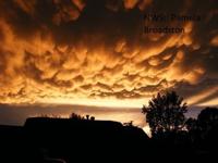
While we can get thunderstorms around here, they are usually not that strong compared to other parts of the country. Mammatus clouds usually form once the strong storm has passed. If they form during sunset they can make for an especially neat display. Some neat mammatus clouds did in fact form earlier this month in Tulsa, Oklahoma. They saw some severe weather prior, and once the storms passed they were left with these neat clouds. The photo above was taken in Kentucky a while back. Unfortunately, I don't know anyone in Tulsa to get permission to use their weather photos.
So how do they form? Opposite of how most clouds form. Most clouds form from warm air rising and condensing. Mammatus clouds form as cold air sinks as the storm collapses. The clouds look like cotton balls, or upside down cottage cheese. It’s like the clouds are punching out of the parent storm. They typically form underneath the anvil of a storm. The anvil is the top of a strong thunderstorm that can fan out.

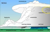
Thunderstorms have updrafts and downdrafts. The updraft is fueled by warm unstable air. The downdraft is cold, dense air that rushes out of the storm as it collapses. Cold air sinks and warm air rises. Since cold air sinks, mammatus clouds looks like the clouds are falling out of the parent storm.
These clouds are rare in Reno, because we usually don’t see very strong thunderstorms. Mammatus clouds form underneath an anvil, and we don’t always have anvils. An anvil is a sign of a severe thunderstorm and a strong updraft. Our thunderstorms usually don’t last long enough to be very strong. The larger and taller the storm is, the stronger it can be.
The storm threat is pretty low through this weekend. With that said, there is a slight chance for areas north of I-80 this weekend. Can’t rule out some thunder and lightning either. Most of us will stay dry though. It will be breezy this weekend with gusts around 30 miles per hour Saturday and closer to 45 miles per hour in wind prone areas Sunday.