Citation report - Victoria's Planning Schemes
Citation report - Victoria's Planning Schemes
Citation report - Victoria's Planning Schemes

You also want an ePaper? Increase the reach of your titles
YUMPU automatically turns print PDFs into web optimized ePapers that Google loves.
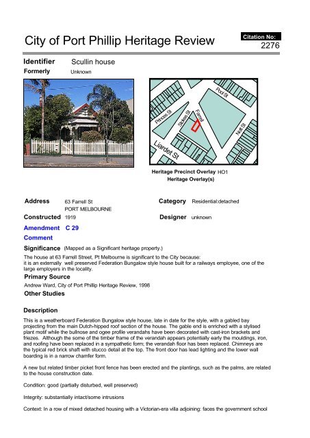
City of Port Phillip Heritage Review<br />
Identifier<br />
Formerly<br />
Address<br />
Constructed 1919<br />
Amendment C 29<br />
Comment<br />
Significance<br />
Description<br />
Scullin house<br />
Unknown<br />
63 Farrell St<br />
PORT MELBOURNE<br />
(Mapped as a Significant heritage property.)<br />
The house at 63 Farrell Street, Pt Melbourne is significant to the City because:<br />
it is an externally well preserved Federation Bungalow style house built for a railways employee, one of the<br />
large employers in the locality.<br />
Primary Source<br />
Andrew Ward, City of Port Phillip Heritage Review, 1998<br />
Other Studies<br />
This is a weatherboard Federation Bungalow style house, late in date for the style, with a gabled bay<br />
projecting from the main Dutch-hipped roof section of the house. The gable end is enriched with a stylised<br />
plant motif while the bullnose and ogee profile verandahs have been decorated with cast-iron brackets and<br />
friezes. Although the some of the timber frame of the verandah appears potentially early the mouldings, iron,<br />
and roofing have been replaced in a sympathetic form; the verandah floor has been replaced. Chimneys are<br />
the typical red brick shaft with stucco detail at the top. The front door has lead lighting and the lower wall<br />
boarding is in a narrow chamfer form.<br />
A new but related timber picket front fence has been erected and the plantings, such as the palms, are related<br />
to the house construction date.<br />
Condition: good (partially disturbed, well preserved)<br />
Integrity: substantially intact/some intrusions<br />
Princes St<br />
Liardet St<br />
Category Residential:detached<br />
Designer unknown<br />
Context: In a row of mixed detached housing with a Victorian-era villa adjoining: faces the government school<br />
Stokes St<br />
Farrell<br />
Heritage Precinct Overlay<br />
Heritage Overlay(s)<br />
Pool St<br />
HO1<br />
Nott St<br />
<strong>Citation</strong> No:<br />
2276
complex which has buildings of a similar era.<br />
History<br />
This house was built for John Scullin, engine driver, in 1919, as a 6 room weatherboard dwelling, housing 10<br />
people. Scullin lived there until the 1930s, followed by Clara Scullin. The number of persons living at the<br />
house had nearly halved in 1930 to 6 { RB}.<br />
The name Scullin is well known in the form of James Scullin the famous politician whose father was John but<br />
the latter lived at Trawalla while James moved from there to Richmond and later to Hawthorn { ADB}. This<br />
John Scullin however was a Victorian Railways employee with the Rolling Stock branch. He was born in 1867<br />
and at the age of 14 joined the railways. In 1914 he was paid 13/6d per week { VGG}. John Scullin died at<br />
Port Melbourne in 1933, the son of John and Ann (nee Logan) { Macbeth}.<br />
Ironically John had commissioned the construction of this house in the year of the national coal strike which<br />
cast most railways employees out of a job. The locomotive sheds at port Melbourne were closed and<br />
unemployment relief committee was set up to cope with the huge unemployment. It was also the year of the<br />
influenza epidemic and disastrous flooding. The nearby school was set up as a temporary hospital { Uren:<br />
213}. Nevertheless Port Melbourne was by then the transport hub of Melbourne at that time with the<br />
Sandridge piers and railway terminus, as well as upgrading of both tramway and rail services in this era.<br />
Thematic Context<br />
Making suburbs<br />
Recommendations<br />
G Butler, Port Phillip Heritage Review, Version 3, 2001<br />
recommended inclusions:<br />
Schedule to the Heritage Overlay Table in the City of Port Phillip <strong>Planning</strong> Scheme<br />
References<br />
VPRO Pt Melbourne Municipal Rate Book (RB) VPRS 586/P;<br />
Macbeth `Death Index Victoria 1921-1985';<br />
Serle (ed) `Australian Dictionary of Biography' (ADB) V11: 553<br />
Uren & Turnbull, 1983, `A History of Port Melbourne' MUP: no index entry;<br />
`Victorian Government Gazette' (VGG) 4/8/1914: 3414
City of Port Phillip Heritage Review<br />
Identifier<br />
Formerly<br />
Address<br />
Constructed 1924<br />
Amendment C 29<br />
Comment<br />
Significance<br />
Anzac Gardens<br />
St. Vincent Place<br />
Ferrars Place<br />
ALBERT PARK<br />
(Mapped as a Significant heritage property.)<br />
Category Public<br />
Designer unknown<br />
The Anzac Gardens were reserved together with St. Vincent Gardens prior to August, 1854 and severed from<br />
the main body of the Gardens by the St. Kilda railway in 1857. The soldiers' memorial hall, now occupied by<br />
the South Melbourne branch of the RSL, was opened in 1924 by the the local branch of the Returned Soldiers<br />
and Sailors Association. They are historically, aesthetically and socially significant.<br />
They are historically significant (Criterion A) as a part of the vision for the St. Vincent Gardens of which the<br />
Victorian Heritage Register states: "The St. Vincent Place Precinct is historically important as the premier<br />
'square' development in Victoria based on similar models in London. It is significant as the largest development<br />
of its type in Victoria and for its unusual development as gardens rather than the more usual small park as at,<br />
for example Macarthur, Murchison, Lincoln and Argyle Squares in Cariton. The precinct is also historically<br />
significant for its associations with Surveyor-General Andrew Clarke, and more particularly with Clement<br />
Hodgkinson, a prolific and influential surveyorlengineer in early Melbourne". The memorial hall and the naming<br />
of the gardens after the Anzacs is historically significant for its capacity to recall the sacrifices made by the<br />
community of South Melbourne during the Great War and subsequently.<br />
The gardens are aesthetically significant (Criterion E) for their relationship with the St. Vincent Gardens, the<br />
Anzac Gardens forming the eastern end of these gardens and in this respect forming an inseparable part of<br />
them. Their aesthetic values are reinforced by the position of the memorial hall on the axis of James Service<br />
Place which is reflected also in the position of the tower to the former St. Vincents Boys'Orphanage. The<br />
Victorian Heritage Register for the St. Vincent Gardens staes that the place is "aesthetically important for the<br />
outstanding quality of its urban landscape. The major elements that reflect this importance are the gardens<br />
with their gardenesque style layout and fine collections of mature specimen trees, and the harmonious<br />
relationship of the gardens with the residential buildings facing them around St. Vincent Place". The latter<br />
attribute also applies to the Anzac Gardens.<br />
The gardens and hall have social significance (Criterion G) for the value placed upon therri by the community<br />
of South Melbourne and especially in recognition of the sacrifices of those who served in the world wars.<br />
Ferrars St<br />
Ferrars Pl<br />
Heritage Precinct Overlay<br />
Heritage Overlay(s)<br />
James Service Pl<br />
HO3<br />
<strong>Citation</strong> No:<br />
2236
Primary Source<br />
Andrew Ward, City of Port Phillip Heritage Review, 1998<br />
Other Studies<br />
Description<br />
The Anzac Gardens consist of public gardens and a centrally placed Memorial Hall. The hall is a symmetrical<br />
stripped Classical Revival building in red face brick with stuccoed parapet, frieze and stuccoed band at first<br />
floor level. There is a hipped terra cotta tiled roof, partially concealed by a central projecting front section with<br />
parapet and curved pediment and flag pole surmounting the principal entry and cartouche reading "Memorial<br />
Hall" in low relief. The eaves are bracketed, the upper sashes of the double hung windows are multi-paned<br />
and the secondary elevations are understated.<br />
The hall is located on the axis of the Anzac Gardens which have a semi-circular shape. It faces James<br />
Service Place which reinforces the axial location of the hall and which is itself terminated at the east end by<br />
the tower of the former St. Vincent de Paul Boys' Orphanage.<br />
The Gardens themselves are sympathetic and have a recent path layout, ornamental lights and recent<br />
plantings. They have been separated from the St. Vincent Gardens area by the St. Kilda railway route and<br />
Ferrars Street.<br />
History<br />
The subdivision plan including St. Vincent Place was formed prior to August 1854, possibly to the design of<br />
Andrew Clarke, the Surveyor-General of Victoria. The present layout of the gardens is the work of Clement<br />
Hodgkinson. The original scheme shows St. Vincent Place having identical elliptical gardens at either end, the<br />
eastern gardens being subsequently severed from the main body of the gardens by the St. Kilda railway. The<br />
line was opened on 13th. May, 1857 by the Melbourne and Hobson's Bay Railway Company and in 1868 the<br />
Council assumed formal control of the public gardens including St. Vincent Place. It commenced to develop<br />
the gardens in the following year.<br />
Initially, Ferrars Place ran parallel with the railway at the back of the Gardens and Service Crescent was the<br />
name given to the curved street forming the characteristic curved end to the Gardens. This rear roadway has<br />
since been closed. After the Great War, the mayor of the City of South Melbourne launched an appeal for a<br />
soldiers ' memorial. A site in Service Crescent, looking across the railway cutting to St. Vincent Gardens was<br />
chosen in 1920 but the construction of a memorial hall did not start for another three years, the opening taking<br />
place in April, 1924. Prior to this, the local branch of the Returned Soldiers and Sailors Association had met in<br />
the drill hall. On 25th. April, 1952 a stone was laid and dedicated by the State president of the R-S.S. and<br />
A.I.L.A in honour of those who served in the 1939-45 war.<br />
Thematic Context<br />
4. Building settlements, towns and cities<br />
8. Developing cultural institutions and ways of life<br />
8.1 Organising recreation<br />
8.1.3 Developing public parks and gardens<br />
Recommendations<br />
A Ward, Port Phillip Heritage Review, 1998<br />
recommended inclusions:<br />
Victorian Heritage Register<br />
National Estate Register<br />
Schedule to the Heritage Overlay Table in the City of Port Phillip <strong>Planning</strong> Scheme<br />
References<br />
Priestley, S_ "South Melbourne A History", MUP, 1995, esp. p.292.<br />
Statement of Cultural Heritage Significance for St. Vincent Place Precinct, Albert Park, Victorian Heritage<br />
Register.
City of Port Phillip Heritage Review<br />
Identifier<br />
Formerly<br />
Address<br />
Constructed 1866<br />
Amendment C 29<br />
Comment<br />
Significance<br />
Description<br />
House<br />
unknown<br />
15 Ferrars Place<br />
SOUTH MELBOURNE<br />
15 Ferrars Place is of significance as one of the first houses built on the St Vincent Place subdivision and for<br />
retaining its timber and cast iron decoration that distinguishes it from the complex cast iron decoration typical<br />
of similar buildings of the following two decades.<br />
Primary Source<br />
Original Use: Residence<br />
Date of Construction: 1866 (1)<br />
Category Residential:row<br />
Designer unknown<br />
Allom Lovell Sanderson Pty. Ltd., South Melb Conservation study vol. 2, 1987<br />
Other Studies<br />
James Service Pl<br />
Prior to 1865, block 38 Ferrars Place (originally Service Crescent) does not appear in the South Melbourne<br />
Rate Books and the St Vincent Place subdivision of which this was a part had not begun to be built upon(2).<br />
However by 1866 a George Wharton was listed as the owner of an ‘unfinished’ six-roomed brick and slate<br />
house given an initial N.A.V. of £50 (3). Wharton was a master tailor and occupied this house until the early<br />
1870s (4) when he sold to George Anthoness, a commercial traveller (5). By 1882 the property was listed as<br />
having ten rooms with an N.A.V. of £58 and was occupied by Walter Rayson, a draper (6). Immediately prior<br />
to the turn of the century and during the economic depression of the 1890s, the building (7) had decreased its<br />
N.A.V. to £31 (8). At that time it was occupied by Patrick Corrigan, a police constable (9).<br />
The house is two storeyed and built with a terrace form. In a manner typical to the 1860s, the walls are in<br />
render and are generally undecorated, the only relief being the ruling in the render to represent ashlar blocks.<br />
The main source of decoration to the house is applied to the two storeyed verandah, with the ground floor<br />
having a stop-chamfered timber frame within which are set diagonal timbers in the manner of the cross of St<br />
Ferrars Pl<br />
Heritage Precinct Overlay<br />
Heritage Overlay(s)<br />
HO3<br />
Cecil St<br />
Howe Cr<br />
<strong>Citation</strong> No:<br />
987
Andrew. These are combined with an elegant cast iron frieze and balcony balustrading at first floor level. The<br />
cast iron fence is partially intact and so too the corrugated iron fence with timber capping that extends down<br />
the north boundary.<br />
History<br />
see Description<br />
Thematic Context<br />
unknown<br />
Recommendations<br />
A Ward, Port Phillip Heritage Review, 1998<br />
recommended inclusions:<br />
Schedule to the Heritage Overlay Table in the City of Port Phillip <strong>Planning</strong> Scheme<br />
References<br />
1 City of South Melbourne Rate Books, 1865/66<br />
2 ibid.<br />
3 ibid.<br />
4 ibid, 1869/70<br />
5 ibid., 1873/74<br />
6 ibid., 1881/82<br />
7 The previous street number for the building was 18<br />
8 ibid., 1898/99<br />
9 ibid.
City of Port Phillip Heritage Review<br />
Identifier<br />
Formerly<br />
Address<br />
Constructed 1877<br />
Amendment C 29<br />
Comment<br />
Significance<br />
Description<br />
House<br />
unknown<br />
34 Ferrars Place<br />
SOUTH MELBOURNE<br />
34 Ferrars Place is of significance as a substantial house built for one of south Melbourne’s leading<br />
professionals in the mid-Victorian period. While of a building form common to areas such as East Melbourne,<br />
this house is not of a common scale or form to South Melbourne and it represents one of the larger<br />
developments associated with the St Vincent Place area.<br />
Primary Source<br />
Original Use: Residence<br />
Date of Construction: 1877 (1)<br />
(Mapped as a Significant heritage property.)<br />
Madden St<br />
Category Residential:detached<br />
Designer unknown<br />
Allom Lovell Sanderson Pty. Ltd., South Melb Conservation study vol. 2, 1987<br />
Other Studies<br />
Dr Charles Duret was the owner of fifty-three by ninety-nine feet of vacant land in Crown Section 37B from as<br />
early as 1875 (2). By 1877 he had erected his fifteen-roomed brick mansion, given a first N.A.V. of £130 (3).<br />
Duret started his practice in Emerald Hill quite early in the area’s development (4) and on his retirement Dr<br />
Marcel Crivelli, of the Faculty of Medicine in Paris, carried on the work. Crivelli became the owner and<br />
occupier of Duret’s mansion in 1899 and the property remained in his ownership until the turn of the century<br />
(5) when the Crivelli family built new premises at No. 40 Ferrars Place (q.v.) (6).<br />
The house has a simple rendered façade marked with ruling to represent ashlar blocks and is decorated with<br />
bold architrave mouldings to the opening. The arched moulding and the six panelled front door are intact and<br />
particularly fine. The verandah is decorated with cast iron (although the original nature of all the iron required<br />
verification), and has slate flagging to its floor. The eave is decorated with sparsely set brackets and the<br />
moulded render chimneys and cast iron fence are intact.<br />
Ferrars St<br />
Bridport St<br />
Ferrars Pl<br />
Heritage Precinct Overlay<br />
Heritage Overlay(s)<br />
Howe Cr<br />
HO3<br />
Anderson St<br />
<strong>Citation</strong> No:<br />
Cecil St<br />
993
History<br />
see Description<br />
Thematic Context<br />
unknown<br />
Recommendations<br />
A Ward, Port Phillip Heritage Review, 1998<br />
recommended inclusions:<br />
Schedule to the Heritage Overlay Table in the City of Port Phillip <strong>Planning</strong> Scheme<br />
References<br />
1 City of South Melbourne Rate Books, 1876-1878<br />
2 ibid., 1875/76<br />
3 ibid., 1877/78.<br />
4 National Trust of Australia (Victoria), File No. 2790<br />
5 City of South Melbourne Rate Books, 1900/01<br />
6 Refer <strong>Citation</strong> for 40 Ferrars Place
City of Port Phillip Heritage Review<br />
Identifier<br />
Formerly<br />
Address<br />
Constructed 1901<br />
Significance<br />
Description<br />
"Balladonia"<br />
"Arrou"<br />
Amendment C 29<br />
Comment<br />
40 Ferrars Place<br />
SOUTH MELBOURNE<br />
‘Arrou’ is of significance as one of the largest Edwardian houses in South Melbourne that has a commanding<br />
and restrained design despite the wealth of decoration across its façade. It is a major work by the leading<br />
architect, William Salway.<br />
Primary Source<br />
Original Use: Residence<br />
Date of Construction: 1901 (1)<br />
Architect: William Salway (2)<br />
Bridport St<br />
Category Residential:detached<br />
Designer William Salway<br />
Allom Lovell Sanderson Pty. Ltd., South Melb Conservation study vol. 2, 1987<br />
Other Studies<br />
Dr Marcel Crivelli purchased a row of three wooden houses from Joseph Harper (3), a bootmaker, in 1900 (4)<br />
and demolished them soon after to build this large residence. Described as being of thirteen rooms and<br />
constructed in brick, the house had an initial N.A.V. of £170 (5). Originally named ‘Arrou’ (6), after Charlotte<br />
Crivelli’s birthplace in France, it was subsequently re-named ‘Balladonia’, the origin of which name is not<br />
known. It was one of the first houses in South Melbourne to be wired for electricity, and people <strong>report</strong>edly<br />
congregated outside to catch a glimpse of the light when the front door was opened (7).<br />
‘Arrou’ is one of very few substantial Edwardian houses in South Melbourne; the area generally attracting a<br />
smaller residential building stock by that date. It is two storeyed and squeezed onto a very limited site. As a<br />
result, the façade does not have the degree of modelling that it may have otherwise enjoyed. It is however<br />
picturesque in massing and asymmetry was effectively contrived in a typically Edwardian fashion. Under the<br />
orderly hipped, terracotta-tile roof the walls are busy, with render played against tuckpointed red brickwork. A<br />
Ferrars St<br />
(Mapped as a Significant heritage property.)<br />
Ferrars Pl<br />
Anderson St<br />
Albert Rd<br />
Heritage Precinct Overlay None<br />
Heritage Overlay(s) HO121<br />
<strong>Citation</strong> No:<br />
Cecil St<br />
1020
square window bay extends out at one side of the arched entrance and pedimented coupled windows are<br />
placed on the other side. The whole is lightened in effect by the quite intricately detailed timber decoration to<br />
the small side verandah. The main stylistic references are to the English Vernacular Free Style and the<br />
design shows restraint from the playful roof forms and verandah decoration so often applied to buildings of<br />
the period.<br />
History<br />
see Description<br />
Thematic Context<br />
unknown<br />
Recommendations<br />
A Ward, Port Phillip Heritage Review, 1998<br />
recommended inclusions:<br />
Victorian Heritage Register<br />
National Estate Register<br />
Schedule to the Heritage Overlay Table in the City of Port Phillip <strong>Planning</strong> Scheme<br />
References<br />
1 City of South Melbourne Rate Books, 1899-1901<br />
2 Architects’ Index, University of Melbourne<br />
3 Harper was the owner of vacant land immediately behind this property at what is now known as<br />
10-12 Anderson Street. Refer <strong>Citation</strong> No. ?<br />
4 City of South Melbourne Rate Books, loc.cit<br />
5 ibid., 1900/01<br />
6 National Trust of Australia (Vic.), ‘Notes on 40 Ferrars Place’, by R.G. Crivelli<br />
7 ibid.
City of Port Phillip Heritage Review<br />
Identifier<br />
Formerly<br />
Address<br />
Constructed 1880<br />
Amendment C 29<br />
Comment<br />
Significance<br />
Description<br />
Albert Park Railway Station<br />
unknown<br />
Ferrars St<br />
SOUTH MELBOURNE<br />
The Middle Park Railway Station is of significance for having had a station in this position since<br />
1860, and for the distinction in the design of its buildings on both sides of the line. The impact of<br />
the station buildings on the streetscapes of Ferrars Street and Ferrars Place are integral to the<br />
significance of the whole.<br />
Primary Source<br />
Original Use: Railway Station<br />
Date of Construction: 1880(1)<br />
Architect: Unknown<br />
Madden St<br />
Dundas Pl<br />
Category Public<br />
Designer unknown<br />
Allom Lovell Sanderson Pty. Ltd., South Melb Conservation study vol. 2, 1987<br />
Other Studies<br />
Bridport St<br />
In May 1857(2) the privately owned Melbourne and Hobson's Bay Railway Company opened Melbourne's<br />
second railway - through South Melbourne to St. Kilda - following earlier suggestions that the route should run<br />
parallel to St. Kilda Road(3). The second station along from the city, previously known as the 'Butts' to serve<br />
the shooting practice area of the Royal Victorian Volunteer Artillery( 4), was opened in November 1860(5) .<br />
This was totally rebuilt in 1880(6), to become Albert Park Station, by the contractors Messrs Pritchard and<br />
Blackwood.<br />
In a manner similar to the South Melbourne Railway station, the Middle Park station is built in polychromatic<br />
brickwork with Italianate styling. The east building appears to have been built first, and has heavily bracketed<br />
eaves, coupled chimneys, an extremely fine cast iron infill unit to the entrance arch and an elegant concave<br />
verandah supported on fluted cast iron columns. The west building has red brick walls into which are set with<br />
Ferrars St<br />
Ferrars Pl<br />
Heritage Precinct Overlay None<br />
Heritage Overlay(s) HO119<br />
<strong>Citation</strong> No:<br />
Anderson St<br />
Albert Rd<br />
1150
contrasting bricks, and it has a cantilevered open truss verandah.<br />
History<br />
see Description<br />
Thematic Context<br />
unknown<br />
Recommendations<br />
A Ward, Port Phillip Heritage Review, 1998<br />
recommended inclusions:<br />
Victorian Heritage Register<br />
National Estate Register<br />
Schedule to the Heritage Overlay Table in the City of Port Phillip <strong>Planning</strong> Scheme<br />
References<br />
1. Architects Index, University of Melbourne<br />
2. ibid.<br />
3. C. Daley, 'History of South Melbourne'. p 67<br />
4. ibid. p. 216<br />
5. National Trust Australia (Vic.) 'Port Melbourne and St. Kilda Railway Lines',<br />
research Paper<br />
6. Architects Index, University of Melbourne
City of Port Phillip Heritage Review<br />
Identifier<br />
Formerly<br />
Address<br />
Significance<br />
Description<br />
South Melbourne Railway Station Precinct<br />
unknown<br />
Constructed c. 1857<br />
Amendment C 29<br />
Comment<br />
Ferrars St<br />
SOUTH MELBOURNE<br />
(Mapped as a Significant heritage property.)<br />
The South Melbourne Railway Station complex is of significance as a group of finely designed<br />
structures commenced soon after the laying out of this very early railway line. All have a<br />
distinction of design in their own right and as a group their individual significance is magnified.<br />
Primary Source<br />
Original Use: Railway Station, road and pedestrian bridges<br />
Date of Construction: c.1857(1) (bridges) and 1883(2) (station)<br />
Architect: unknown<br />
Coventry St<br />
Dorcas St<br />
Category Public<br />
Designer unknown<br />
Allom Lovell Sanderson Pty. Ltd., South Melb Conservation study vol. 2, 1987<br />
Other Studies<br />
Coventry St<br />
Dorcas St<br />
In May 1857(3) the privately owned Melbourne and Hobson's Bay Railway Company opened Melbourne's<br />
second railway - through South Melbourne to St. Kilda - following earlier suggestions that the route should run<br />
parallel to St. Kilda Road(4). The first station out from Melbourne was on this site, and was named 'Emerald<br />
Hill' which opened in September the following year(5). The existing station buildings were built in 1883(6)<br />
and adopted the new name of the municipality, South Melbourne(7).<br />
The station is nestled in a cutting that bisects Coventry Street and is part of an attractive railway precinct. An<br />
iron footbridge that crosses the line at the northern end of the buildings and has the name 'Enock Chambers'<br />
cast into the end column and the balusters at either end of the footbridge are embossed with 'P. Johns -<br />
Flinders Lane East' indicating the name of the manufacturer.<br />
Part of the original works associated with the line are the three basalt bridges crossing the railway at Bank,<br />
Ferrars St<br />
Heritage Precinct Overlay None<br />
Heritage Overlay(s) HO120<br />
<strong>Citation</strong> No:<br />
1149
Dorcas and Park Streets. Recorded in the Minutes of the Melbourne and Hobson's Bay Railway Co., of 28<br />
July 1856 is the acceptance of the tender by Hope and McKenzie of £11,000 for the erection of the<br />
bridges(8). This was one of the first (if not the first) road-over-rail crossings in Australia(9). The bridge at<br />
Dorcas Street is incised in the capping with 'W. Elsdon, Engineer, St.K.R'y 1857'.<br />
The station building is typical of the 1880s in its use of polychromatic brickwork over an Italianate-derived<br />
design. In this case the essay is particularly complete, with heavily bracketed eaves and brick and render<br />
chimneys of Italianate styling with coupled expressed shafts. The decoration is continued into the entrance<br />
lobby of the Ferrars Street building with an intact tessellated tile floor, blind arches, and a very fine panelled<br />
timber ceiling set in panels with v-jointed lining boards to each panel. The verandah to the west platform is<br />
supported on fluted iron columns and the brick and iron picket fence is intact to the west of the building. The<br />
east building repeats the polychrome theme, but is less ornate and has a slightly later cantilevered verandah<br />
set on open trusses. Of particular distinction are the timber entrance gates.<br />
The basalt bridges are very simple in their forms and have expressed buttresses immediately flanking the<br />
railway line. The pedestrian bridge is an intact example of an open truss bridge with metal strapwork in the<br />
trusses and timber joists spanning between in order to support the pathway.<br />
History<br />
see Description<br />
Thematic Context<br />
unknown<br />
Recommendations<br />
A Ward, Port Phillip Heritage Review, 1998<br />
recommended inclusions:<br />
Victorian Heritage Register<br />
National Estate Register<br />
Schedule to the Heritage Overlay Table in the City of Port Phillip <strong>Planning</strong> Scheme<br />
References<br />
1. Date on the Dorcas Street Bridge<br />
2. National Trust Australia (Vic.) 'Port Melbourne and St. Kilda Railway Lines',<br />
research Paper p. 8<br />
3. ibid.<br />
4. C. Daley, 'History of South Melbourne'. p 67<br />
5. National Trust Australia (Vic.) loc.cit.<br />
6. ibid.<br />
7. C. Daley, 'History of South Melbourne'. p 143<br />
8. National Trust Australia (Vic.) 'Research into Dorcas-Bank-Park Street Bridges', 19 July 1986<br />
9 . National Trust Australia (Vic.) 'Port Melbourne ..' loc.cit.
City of Port Phillip Heritage Review<br />
Identifier<br />
Formerly<br />
Railway cutting and road bridges<br />
Address 221-351 Ferrars St<br />
SOUTH MELBOURNE<br />
Constructed 1856-57<br />
Amendment C 52<br />
Comment New citation<br />
Significance<br />
Category Public<br />
Designer William Elsdon<br />
What is Significant?<br />
The railway cutting extends for about 800 metres between the former South Melbourne and Albert Park<br />
railway stations. Originally excavated in 1856-57 as part of the St Kilda branch line of the Melbourne &<br />
Hobson’s Bay Railway Company, this landscaped cutting includes three bluestone bridges at Dorcas, Park<br />
and Bank streets.<br />
How is it Significant?<br />
The railway cutting and bridges are of aesthetic and historic significance to the City of Port Phillip.<br />
Why is it Significant?<br />
Aesthetically, the railway cutting is of significance as an important vista between the railway stations at South<br />
Melbourne and Albert Park. Extending in a straight line for almost a kilometre, this notably long view can be<br />
appreciated from several vantage points including the road bridges at Dorcas, Bank and Park streets, the<br />
footbridge at Coventry Street, and the level crossing at Bridport Street. The bridges themselves are important<br />
visual elements, punctuating the vista, while the grassed embankments and mature trees also contribute to<br />
its aesthetic qualities. It contrasts with many other early railway cuttings (eg that in Alma Park) which tend to<br />
be curved. Historically, the railway cutting and road bridges are of significance for their associations with the<br />
initial development of Melbourne’s railway network in the 1850s. Although much of the actual railway<br />
infrastructure was removed following the line’s conversion to a light rail, the cutting itself remains as one of<br />
the oldest and longest in the inner city area, while the three bluestone bridges are also rare and significantly<br />
early surviving examples of their type.<br />
Primary Source<br />
Other Studies<br />
(Mapped as a Significant heritage property.)<br />
Heritage Precinct Overlay<br />
Heritage Overlay(s)<br />
HO3<br />
<strong>Citation</strong> No:<br />
2311
Description<br />
The railway cutting extends for 800 metres between Coventry Street and Bridport Street, corresponding,<br />
approximately, to the portion of railway line between what are now the South Melbourne and Albert Park<br />
light rail stations. The cutting is crossed at Dorcas Street, Bank Street and Park Street by three bluestone<br />
bridges of identical design. Each of these comprises, at the lower level, a central segmental-arched opening<br />
with rock-faced voussoirs, flanked by smoother battered piers, and thence by rock-faced abutments. The<br />
upper level, with smoother ashlar masonry, is delineated by two projecting courses of smooth-faced<br />
stonework. On the inside of this wall, facing the road, the stonework has a bush-hammered finish with a<br />
smooth border, and there are some iron spike railings. The bridge closest to South Melbourne station also<br />
has an engraved panel bearing the name of the original engineer, William Elsdon, and the date 1857.<br />
The steeply sloping sides of the railway cutting are grassed, and there are also a number of mature pepper<br />
trees (Schinus molle, a ubiquitous element along railway reserves such as these) and other plantings. A<br />
number of buildings have been erected alongside the railway cutting, variously fronting Ferrars Street or<br />
Ferrars Place. The scout hall, on Ferrars Place near Bridport Street, is a utilitarian red brick structure with<br />
buttress-like brick piers and a broad gabled roof. The premises of the South Melbourne Cycle Club at 335-<br />
337 Ferrars Street is a red brick building, apparently of Edwardian or inter-war vintage, which is enlivened by<br />
rendered stringcourses, scotia cornices and flat-arched windows with steel-framed casement sashes. There<br />
is also row of townhouses, of quite recent origin, at 339-349 Ferrars Street.<br />
History<br />
The first railway line in the present-day City of Port Phillip, and also the first public steam train service in<br />
Australia, was the 2¼ mile (3.6 kilometre) link between Sandridge Pier to Flinders Street, which was laid out<br />
from 1852 by the Melbourne & Hobson’s Bay Railway Company. This opened on 12 September 1854 and<br />
such was its success over the next twelve months that the company, having returned an eight percent<br />
dividend to its shareholders, decided to erect a branch line to St Kilda. A public meeting was held in<br />
December 1855 to consider possible routes; A proposal to locate the line to the south and west of the hill<br />
was rejected by residents, who considered that it would hinder their access to the beach, and it was<br />
subsequently decided that the line should be on the east of the hill, along Moray Street. Early the following<br />
year, this option was also dropped when a select committee deemed it too expensive. Instead, it was<br />
decided that the new line should neither follow the east or west of the hill but, rather to extend through the<br />
centre of it, parallel to Ferrars Street.<br />
Construction of the branch line commenced in Spring 1856, with 200 workmen under the direction of the<br />
company engineer, William Elsdon, who had replaced its original engineer, James Moore, in December<br />
1854. The new line turned off the main Sandridge railway soon after the Flinders Street terminus, extending<br />
3 miles (4.8 kilometres) to a purpose-built station building on Fitzroy Street. Completion of the project was<br />
delayed due to difficulties with the original contractor, who was eventually replaced by another from Sydney,<br />
and the new line opened on 13 May 1857. Over the next few years, the Melbourne & Hobson’s Bay Railway<br />
Company upgrading both of its lines, which included the duplication of tracks and the opening of new<br />
stations. On the St Kilda branch, stations were opened at Emerald Hill (now South Melbourne) in September<br />
1858, and at Butts (now Albert Park) in November 1860.<br />
Thematic Context<br />
COMPARATIVE ANALYSIS<br />
The railway cutting at South Melbourne can be compared to a small number of similar cuttings in the inner<br />
metropolitan area. In terms of its early date, it is most comparable to the cutting that runs between Windsor<br />
Station and Alma Road, East St Kilda. The railway line between Windsor and North Brighton opened on 19<br />
December 1859, being part of a longer route to Brighton Beach that was laid out by the St Kilda & Brighton<br />
Railway Company, in several stages, from 1858. The cutting, which is approximately 600 metres long,<br />
bisects Alma Park and includes the road bridges at Chapel Street and Dandenong Road. The cutting retains<br />
some historic infrastructure, including red brick bridges and retaining walls (within the City of Stonnington),<br />
while the portion through Alma Park (within the City of Port Phillip) is delineated by rows of mature pepper<br />
trees. While this cutting is clearly of some aesthetic and value, it is of a curving form and thus lacks the<br />
continuous vista qualities that are so strongly evident at South Melbourne. A second cutting, in the portion<br />
between Hotham Street and Elsternwick Station, is straighter but shorter (about 500 metres), and this is<br />
located within the City of Glen Eira.<br />
Other railway cuttings in the inner suburbs also tend to be of curved profile, and are generally shorter, and of<br />
more recent origin, than the example at South Melbourne. The cutting between Brewster Street and<br />
Glenbervie station in Essendon, which dates from 1872, is about 500 metres long and is also of a gently
curving form. Like the cutting at South Melbourne, it has roadways running parallel to it. Slightly different is<br />
the example that runs between Jolimont and West Richmond Stations. This is a distinctive element in that<br />
local landscape, as it actually runs below houses and incorporates two bridges and a long viaduct beneath<br />
Wellington Parade. Laid out during 1901 as part of the railway line between Princess Bridge and<br />
Collingwood, this cutting is also about 600 metres long, and curves at a particularly sharp angle.<br />
Further east is the substantial railway cutting between Burwood Road and Camberwell Station, which dates<br />
from 1882. This is about 800 metres long, and, with multiple tracks, is considerably wider than its<br />
counterpart at South Melbourne. It is also curved, thereby lacking the same vista qualities. It is of aesthetic<br />
significance in its own right, but its character is more industrial; the western portion, running parallel to<br />
Burwood Avenue/Auburn Parade, having vast buttressed red brick retaining walls, some with early painted<br />
advertising signage.<br />
Recommendations<br />
Schedule to the Heritage Overlay Table in the City of Port Phillip <strong>Planning</strong> Scheme.<br />
References<br />
Leo Harrigan. Victorian Railways to ’62. pp 38-43.<br />
Susan Priestley South Melbourne: A History. pp 86-87.
City of Port Phillip Heritage Review<br />
Identifier<br />
Formerly<br />
Address<br />
Constructed 1876<br />
Amendment C 29<br />
Comment<br />
Significance<br />
Description<br />
Former Freemasons Hall<br />
unknown<br />
254-256 Ferrars St<br />
SOUTH MELBOURNE<br />
(Mapped as a Significant heritage property.)<br />
The former Freemasons Hall is of significance as a South Melbourne landmark and for having been built to<br />
house the Yarra Yarra Masonic Lodge. Architecturally it is also one of the most commanding institutional<br />
buildings in the area and is unusual in its two storeyed form for a hall structure. The building’s significance is<br />
enhanced by its intact state.<br />
Primary Source<br />
Original Use: Freemasons Hall<br />
Date of Construction: 1876 (1)<br />
Architect: Adamson and McKean (2)<br />
Dorcas St<br />
Category Public<br />
Allom Lovell Sanderson Pty. Ltd., South Melb Conservation study vol. 2, 1987<br />
Other Studies<br />
Designer Adamson and McKean<br />
The site of the Freemasons Hall on the south-west corner of Dorcas Street was acquired by the Yarra Yarra<br />
Masonic Lodge in 1875 (3). The following year and at a cost of £2,000 (4), Leonard Haffner (5) was<br />
commissioned to build the hall to the designs of local Emerald Hill architects, R. Adamson and W. McKean.<br />
Erected as the first permanent rooms of the Yarra Yarra (Scottish) Lodge, No. 714 E.C. (6), the building was<br />
used by the Freemasons until 1881, when financial difficulties forced them to vacate (7). After a short period<br />
in the hands of real estate agents (8) the building was owned and occupied from at least 1884, by Henry<br />
Mortimer Franklyn, the Victorian publisher and journalist. Although no confirming evidence has been found it<br />
is thought that Franklyn may have used the Masonic Hall for publishing purposes (9). James Munro,<br />
businessman, former Premier and Treasurer of Victoria, is listed as the following owner of the building in<br />
1887(10), when it is described as a hall and store, having an N.A.V. of £150 (11). By 1895 the ‘Try Boys<br />
Society’ were the new occupants (12). The Yarra Yarra Lodge re-acquired the hall in 1910, however with<br />
Ferrars St<br />
Heritage Precinct Overlay None<br />
Heritage Overlay(s) HO122<br />
<strong>Citation</strong> No:<br />
1098
increasing membership it again became necessary to secure new premises (13).<br />
On its corner site, the hall is a landmark in South Melbourne and while relatively close to the Town Hall, it is<br />
one of the few institutions to have been built to the west of the St Kilda railway line. The façade is fashioned<br />
in render, the ground floor with its rusticated piers forming the basement course to the decorated piano nobile<br />
floor above. The first floor is decorated with shallow corinthian pilasters and the cornice above it is<br />
surmounted by a balustrated parapet. The Coat of Arms, name and date remain intact above the Dorcas<br />
Street entrance, while the Ferrars Street entrance houses a commanding entrance way.<br />
History<br />
see Description<br />
Thematic Context<br />
unknown<br />
Recommendations<br />
A Ward, Port Phillip Heritage Review, 1998<br />
recommended inclusions:<br />
Victorian Heritage Register<br />
National Estate Register<br />
Schedule to the Heritage Overlay Table in the City of Port Phillip <strong>Planning</strong> Scheme<br />
References<br />
1 National Estate, ‘Listing for South Melbourne Freemason’s Hall’, as at 22 September 1986<br />
2 Architects’ Index, University of Melbourne<br />
3 National Trust of Australia (Vic.), ‘Submission for the Addition of the Former, Freemason’s Hall…’,<br />
held in File No. 2746<br />
4 HBPC, ‘Findings of the Sub-committee’, in File No. 83/2803<br />
5 ibid.<br />
6 National Trust of Australia (Vic.), ‘Building <strong>Citation</strong>: 254-256 Ferrars Street’<br />
7 National Trust of Australia (Vic.), ‘Submission for the Addition…’<br />
8 ibid.<br />
9 [not recorded]<br />
10 ibid.<br />
11 City of South Melbourne Rate Books, 1887/88<br />
12 An inscription on the front wall of the building reads ‘South Melbourne Try Boys’ Society, 1895’<br />
13 National Trust of Australia (Vic.), ‘Submission for the Addition…’
City of Port Phillip Heritage Review<br />
Identifier<br />
Formerly<br />
Address<br />
Constructed 1881<br />
Amendment C 29<br />
Comment<br />
Significance<br />
Description<br />
House<br />
unknown<br />
44 Finlay St<br />
SOUTH MELBOURNE<br />
44 Finlay Street is of significance as an investment property built for the leading South Melbourne<br />
businessman, W.P. Buckhurst and for the intricate nature and the substantially intact state, of the timber<br />
decoration.<br />
Primary Source<br />
Original Use: Residence<br />
Date of Construction: 1881 (1)<br />
Manufacturers: Unknown<br />
Category Residential:detached<br />
Designer unknown<br />
Allom Lovell Sanderson Pty. Ltd., South Melb Conservation study vol. 2, 1987<br />
Other Studies<br />
Finlay St<br />
William Parton Buckhurst, the highly successful South Melbourne real estate entrepreneur built a row of<br />
speculative houses in Finlay Street, including No. 44, 1881-82. This six-roomed wooden dwelling was first<br />
rated at £14 (2). The following rateable period of the N.A.V. had jumped to £34 and was then owned and<br />
occupied by William Robertson, a tailor (3). After about six years, ownership passed to Thomas Brown, a<br />
‘manufacturer’, who leased it to Henry Green, a miner (5). By 1900 Brown and Green still owned and<br />
occupied the property.<br />
The house, while a small building and built as an investment property, was given some very unusual querks of<br />
detailing that remain substantially intact. The house is clad in timber to represent ashlar blocks, but is<br />
dominated by the projecting gable and the decoration under it. The barge board has an accentuated<br />
scalloped edge and turned timber finial and drops, while the bay window under has – all in timber – bold<br />
castellation drowning it, a moulded cornice, hood moulds terminated with consoles to each of the three double<br />
Moubray St<br />
(Mapped as a Significant heritage property.)<br />
Heritage Precinct Overlay<br />
Heritage Overlay(s)<br />
HO3<br />
Merton St<br />
<strong>Citation</strong> No:<br />
964
hung sash windows, and the whole is flanked by pilasters. Despite such intricate work in timber, the building<br />
remains substantially intact. The main elements that have not survived are the frieze and capitals to the<br />
verandah.<br />
History<br />
see Description<br />
Thematic Context<br />
unknown<br />
Recommendations<br />
A Ward, Port Phillip Heritage Review, 1998<br />
recommended inclusions:<br />
Schedule to the Heritage Overlay Table in the City of Port Phillip <strong>Planning</strong> Scheme<br />
References<br />
1 City of South Melbourne Rate Books, 1881-1882<br />
2 ibid.<br />
3 1861-1862<br />
5 ibid, 1890-1901
City of Port Phillip Heritage Review<br />
Identifier<br />
Formerly<br />
Address<br />
Constructed 1857<br />
Significance<br />
Description<br />
Railway Station and Surrounds<br />
unknown<br />
Fitzroy St<br />
ST. KILDA<br />
Amendment C 29<br />
Comment<br />
(Mapped as a Significant heritage property.)<br />
Mary St<br />
Category Public<br />
Designer unknown<br />
This railway station is very important as it is an early Victorian example of this building type and the only one to<br />
remain from the days of the Melbourne and Hobson's Bay, Railway Company. The unique platform canopy<br />
dates from the original construction and is substantially intact. The bluestone retaining wall dating from 1857<br />
and Edwardian planting featuring mature date palms are an important part of the complex.<br />
Primary Source<br />
Nigel Lewis and Associates, St. Kilda Conservation Study, 1982<br />
Other Studies<br />
Canterbury Rd Fitzroy St<br />
West Beach Rd<br />
The St Kilda Railway Station was erected for the opening of the line on 13th May 1857 at the termination of a<br />
Hobson's Bay Railway Company branch line and included refreshment, retiring rooms and a bar. The<br />
restrained Italianate building originally featured a semi-circular portico probably demolished in 1913, when<br />
buildings were also erected at the southern end of the station and the single train track was duplicated. The<br />
unusual platform canopy displays timber valencing and is supported on open web joists. A timber signal box<br />
and mature railways planting (probably dated from the 1906 renovations) all add character to the precinct.<br />
The bluestone retaining wall along Canterbury Road is clearly shown in an 1857 engraving by Sands, Kenny &<br />
Co.<br />
Intactness<br />
The demolition of the portico, the addition of buildings, the lengthening of the platform and the bricking up of<br />
openings detract from the original design, although the original platform canopy (extended on the Fitzroy<br />
Street end) and timber valencing remain substantially intact as does the platform elevation.<br />
Loch St<br />
Heritage Precinct Overlay None<br />
Heritage Overlay(s) HO123<br />
Grey St<br />
<strong>Citation</strong> No:<br />
153
History<br />
see Description<br />
Thematic Context<br />
unknown<br />
Recommendations<br />
A Ward, Port Phillip Heritage Review, 1998<br />
recommended inclusions:<br />
Victorian Heritage Register<br />
National Estate Register<br />
Schedule to the Heritage Overlay Table in the City of Port Phillip <strong>Planning</strong> Scheme<br />
References<br />
'The Illustrated Journal of Australasia', vol.4, No.XXl, March, 1858, p.119<br />
'The Illustrated Melbourne Post', 9 August 1862, p5<br />
Ward, A., '<strong>Victoria's</strong> Railway Stations. An Architectural Survey'. Vol.2 Nov. 1980.<br />
Information from Andrew Ward, 1982.<br />
The Age, 14th May 1857.
City of Port Phillip Heritage Review<br />
Identifier<br />
Formerly<br />
Address<br />
Constructed 1882<br />
Significance<br />
Description<br />
St Kilda Park Primary School<br />
unknown<br />
Fitzroy St<br />
ST. KILDA<br />
Amendment C 29<br />
Comment<br />
Canterbury Rd<br />
(Mapped as a Significant heritage property.)<br />
Category School<br />
Designer H. R. Bastow<br />
This building provides an intact example of the more exuberant style of Gothic adopted for Victorian schools.<br />
The two-storey splayed corner element is unusual. The school is situated at the edge of an important<br />
architectural area of St Kilda.<br />
Primary Source<br />
Nigel Lewis and Associates, St. Kilda Conservation Study, 1982<br />
Other Studies<br />
Fitzroy St<br />
The St Kilda Park Primary School was erected in 1882 by contractors Beardall and Glenncross to a design of<br />
architect H.R. Bastow prepared three years earlier. As early as 1874 land was applied for, but it was not<br />
granted until 1878 when a bill was passed in the Legislative Assembly for the annexure of land from the<br />
permanent reserve, Albert Park. The two-storey, red brick school is in the Gothic style, which had been<br />
developing in the late 1870s in Victorian school design. Polychromatic brickwork, pointed arches surmounting<br />
openings and steep gable roofs give a Gothic character. The two storey splayed corner element is unusual in<br />
school design, but provides a visual transition between the two facades. A prominent tower exhibits<br />
decorative iron cresting and arches below supported on iron columns. Similar school plans were adopted in<br />
the late 1880s.<br />
Intactness<br />
This school building is very intact and the steep roof has been re-slated. Additions and alterations were<br />
carried out in 1923 and two additional rooms erected in 1969.<br />
Grey St<br />
Dalgety St<br />
Heritage Precinct Overlay None<br />
Heritage Overlay(s) HO124<br />
<strong>Citation</strong> No:<br />
Princes St<br />
154
History<br />
see Description<br />
Thematic Context<br />
unknown<br />
Recommendations<br />
A Ward, Port Phillip Heritage Review, 1998<br />
recommended inclusions:<br />
Victorian Heritage Register<br />
National Estate Register<br />
Schedule to the Heritage Overlay Table in the City of Port Phillip <strong>Planning</strong> Scheme<br />
References<br />
Blake, L.J. (ed)' Vision and Realisation', vol.3, p.377, Education Department of Victoria, 1973.<br />
Burchell, L.' Victorian Schools, A Study in Colonial Government Architecture, 1837-1900', Melbourne, 1980.<br />
Cooper, J.B. 'The History of St Kilda', vol.1, p.391. Melbourne, 1931.
City of Port Phillip Heritage Review<br />
Identifier<br />
Formerly<br />
Address<br />
Significance<br />
Description<br />
Wesleyan Church Complex<br />
unknown<br />
Fitzroy St<br />
ST. KILDA<br />
Constructed 1857-58<br />
Amendment C 29<br />
Comment<br />
The Wesleyan church itself is an early building of its type and together with the other buildings on the site,<br />
forms an intact complex of church buildings.<br />
Primary Source<br />
Nigel Lewis and Associates, St. Kilda Conservation Study, 1982<br />
Other Studies<br />
The existing bluestone Wesleyan Church, Fitzroy Street, was erected in 1857-58, and was the second church<br />
to be built on the site. Designed by Crouch and Wilson, the Gothic church features a square central entrance<br />
tower with Early English stepped buttresses and pinnacles above. The sides of the rectangular nave feature<br />
narrow lancet windows which alternate with buttresses. Adjacent to the church is a brick school building which<br />
replaced the original timber one in 1888. The red brick Gothic building, which features cream brickwork, was<br />
designed by Percy Oakden. The original parsonage, erected in Princes Street at the rear of the church in<br />
1856 and designed by T.J. Crouch, was demolished in 1888 and the second one erected in the following year.<br />
This two storey residence was probably designed by Percy Oakden and Ralph Wilson and built by T.B. Allen.<br />
The fourth building on the site is the third parsonage which was designed by A. Eggleston, the result of an<br />
architectural competition early this century and erected by R.J. Jones.<br />
Intactness<br />
The complex of buildings are substantially intact.<br />
History<br />
see Description<br />
(Mapped as a Significant heritage property.)<br />
Fitzroy St<br />
Princes St<br />
Category Church<br />
Pattison St<br />
Heritage Precinct Overlay None<br />
Heritage Overlay(s) HO128<br />
Designer Crouch and Wilson<br />
<strong>Citation</strong> No:<br />
155
Thematic Context<br />
unknown<br />
Recommendations<br />
A Ward, Port Phillip Heritage Review, 1998<br />
recommended inclusions:<br />
Victorian Heritage Register<br />
National Estate Register<br />
Schedule to the Heritage Overlay Table in the City of Port Phillip <strong>Planning</strong> Scheme<br />
References<br />
Griffiths, A.B. and von Hartel, Y., 'An Architectural History of the Wesleyan Methodist Church, St<br />
Kilda'., Research Essay, 1965, Department of Architecture, University of Melbourne.<br />
Cooper, J.B., 'The History of St Kilda', Vol 1, p.354-6, Melbourne, 1931.
City of Port Phillip Heritage Review<br />
Identifier<br />
Formerly<br />
Address<br />
Constructed c 1900<br />
Amendment C 29<br />
Comment<br />
Significance<br />
Description<br />
"Elenara" and "Thalassa"<br />
unknown<br />
Cnr. Fitzroy St and Beaconsfield Pde<br />
ST. KILDA<br />
(Mapped as a Significant heritage property.)<br />
Beaconsfield Pde<br />
Category Residential:detached<br />
Designer unknown<br />
Elenara and Thalassa are intact examples of large Edwardian residences erected in St Kilda. In addition to<br />
their architectural significance, the buildings are located in a critical position, at the gateway to the important<br />
foreshore area, opposite the Catani Gardens. The pair of buildings form an extremely important link at the<br />
corner of Fitzroy Street and Beaconsfield Parade. In spite of the losses of important buildings in both these<br />
streets the survival of this corner group manages to maintain much of the original character of this area.<br />
Primary Source<br />
Nigel Lewis and Associates, St. Kilda Conservation Study, 1982<br />
Other Studies<br />
Fitzroy St<br />
Elenara and Thalassa, Fitzroy Street, St Kilda are two adjacent Edwardian residences erected at the<br />
beginning of this century. A contemporary description in 1914 spoke glowingly of Elenara:<br />
"A home of palatial residences and hotels is Fitzroy-street, the main thoroughfare leading down to the<br />
Esplanade, but none are more attractive than "ELENARA" at the corner of Acland-street, with its quaint<br />
architecture and great stretch of windows, making one of the most pleasant pictures on a summer's eve when<br />
the lights are glowing. It gives so reposeful an impression, and that is deepened as one moves through the<br />
sumptuously furnished and carpeted rooms, finished with the touch of an artist. Facing the water, just a few<br />
steps from all the life, and joy of the Esplanades it is an ideal private residential hotel."<br />
Originally both of exposed red brickwork, the buildings feature many elements of the Federation period often<br />
in an extreme manner. The two storey residences incorporate half-timbered gables, bow and bay windows<br />
with leaded glass, rectangular, triangular and oriel de boeuf windows, timber fretwork, arches, a glazed tile hip<br />
and gable roof with terracotta ridging and finials, and substantial tall red brick chimneys. Cement render is<br />
Acland St<br />
Heritage Precinct Overlay<br />
Heritage Overlay(s)<br />
Park St<br />
HO3<br />
<strong>Citation</strong> No:<br />
92
employed to highlight window bays and to provide a continuous contrasting band around the buildings. The<br />
resulting compositions are highly asymmetrical, complex and diverse and show the influence of the Queen<br />
Anne revival style in England in the latter half of the nineteenth century.<br />
Intactness<br />
Both residences are substantially intact with Elenara retaining its exposed brick and render facades.<br />
History<br />
see Description<br />
Thematic Context<br />
unknown<br />
Recommendations<br />
A Ward, Port Phillip Heritage Review, 1998<br />
recommended inclusions:<br />
National Estate Register<br />
Schedule to the Heritage Overlay Table in the City of Port Phillip <strong>Planning</strong> Scheme<br />
References<br />
Sands and McDougall Directories, various dates.<br />
St. Kilda by the Sea, 1914, p. 95, also illustration.<br />
Rose postcard, u.d. held by City of St Kilda.
City of Port Phillip Heritage Review<br />
Identifier<br />
Formerly<br />
Address<br />
Significance<br />
Description<br />
George Hotel<br />
Terminus Hotel<br />
Constructed 1889, 1925<br />
Amendment C 29<br />
Comment<br />
Cnr. Fitzroy St and Grey Street<br />
ST. KILDA<br />
(Mapped as a Significant heritage property.)<br />
Canterbury Rd<br />
Category Commercial: residential<br />
Designer See DESCRIPTION<br />
The George Hotel, situated at the terminus of the St Kilda railway line, is historically important as an early<br />
landmark in this fashionable seaside resort. It stands on a site which sported a hotel from early days of St<br />
Kilda. The Victorian building is typical of the hotels erected during the boom years in Melbourne, and is a<br />
reasonably intact example.<br />
Primary Source<br />
Nigel Lewis and Associates, St. Kilda Conservation Study, 1982<br />
Other Studies<br />
Fitzroy St<br />
Grey St<br />
Heritage Precinct Overlay None<br />
Heritage Overlay(s) HO127<br />
Dalgety St<br />
<strong>Citation</strong> No:<br />
Originally the Terminus Hotel stood on this site although this was renamed in 1867 by the new proprietor,<br />
Charles Forster after the George Hotel, Ballarat. Extensions and alterations to the hotel occurred with one<br />
extensive addition being designed by Robert Rusby Cowl in 1873 for the proprietor Fredrick Wimpole (who<br />
owned the hotel from 1870 to well into the next century). The hotel as it exists today comprises two buildings<br />
which reflect two styles; one being erected on the corner by 1889 and the other adjoining in Fitzroy Street in<br />
1925. The four storey Victorian building originally of two hundred and fifty rooms, was designed by Harry B.<br />
Gibbs and features a curved corner tower and recessed balconies on both elevations. Arched openings<br />
dominate the composition with applied decoration including Corinthian pilasters and bosses. The 1925 section<br />
which abuts the earlier one is an austere building of five storeys which employs vertical oriel window bays to<br />
relieve the facade. Strips of rectangular windows maintain the horizontal line of the Victorian building and the<br />
parapet is balustraded in a similar manner to the adjoining building.<br />
Intactness<br />
The existing building is reasonably intact and the extensive 1925 addition does not distract greatly from the<br />
earlier building. A mansard roof to the corner tower shown in an early illustration is no longer extant.<br />
94
History<br />
see Description<br />
Thematic Context<br />
unknown<br />
Recommendations<br />
A Ward, Port Phillip Heritage Review, 1998<br />
recommended inclusions:<br />
Victorian Heritage Register<br />
National Estate Register<br />
Schedule to the Heritage Overlay Table in the City of Port Phillip <strong>Planning</strong> Scheme<br />
References<br />
'Argus', 29 October 1873, s.p.2.<br />
'Building, Engineering and Mining Journal', 30 November 1889, p.450.<br />
Davison, G (ed),'Melbourne on Foot', p. 128 Melbourne, 1980.<br />
Smith, J. (ed), 'The Cyclopedia of Victoria', Melbourne, 1903, vol. 1, p. 384.<br />
R.K. Cole, 'Hotel Records' held at State Library of Victoria.
City of Port Phillip Heritage Review<br />
Identifier<br />
Formerly<br />
Address<br />
Significance<br />
Description<br />
Summerland Mansions<br />
Summerland House<br />
17-25 Fitzroy St<br />
ST. KILDA<br />
Constructed 1920-1921<br />
Amendment C 29<br />
Comment<br />
(Mapped as a Significant heritage property.)<br />
Summerland is of significance both as a key example of the `flats over shops' building type and as an example<br />
of mansion flats. This combination together with the scale of the apartments and the scale of the complex as<br />
a whole, sets it apart from other buildings of this type. This significance is enhanced by the sophisticated<br />
relationship of the design to the predominantly commercial Fitzroy Street frontage on one hand, and the<br />
residential Acland Street on the other. Its location in St Kilda reflects a key part of St Kilda's history as an<br />
important seaside resort in the first half of the twentieth century. Architecturally, it is a fine representative<br />
example of a transitional style between the eclectic survival of the early 20th century and the emergent<br />
functionalist styles.<br />
Primary Source<br />
Style : Arts and Crafts, Free Classical<br />
Two and three storey walk-up flats, shops<br />
Original owner: ER & GHC Crespin<br />
Beaconsfield Pde<br />
Fitzroy St<br />
Category Commercial: residential<br />
Designer Christopher A Cowper<br />
Robert Peck von Hartel Trethowan, St Kilda 20th century Architectural Study Vol. 3, 1992<br />
Other Studies<br />
Jackson St<br />
"Summerland Mansions" is a complex of shops and large residential flats situated on the corner of Fitzroy and<br />
Acland Streets. The site itself is strongly connected with St Kilda's earliest history. It was the first block of<br />
land sold in the first Crown Land sales in St Kilda in December 1842. The buyer, Lieut. James Ross<br />
Lawrence RN, was Captain of the schooner "Lady of St Kilda" from which the city took its name. Captain<br />
Lawrence named Acland Street after Sir Thomas Dyke Acland, the owner of the vessel.<br />
Before Elsie Rowe Crespin and her husband GHC Crespin acquired the property in 1919, it had been known<br />
Acland St<br />
Heritage Precinct Overlay None<br />
Heritage Overlay(s) HO345<br />
<strong>Citation</strong> No:<br />
1472
as "Summerland House", a Victorian mansion owned by Georgina Wilson Watt. They engaged the architect<br />
Christopher A. Cowper of Collins Street to redevelop the site as the grand block of mansion flats and<br />
incorporated shops that remains to this day.<br />
The flats were built in two stages. The first part was the main three storey section fronting Fitzroy Street<br />
consisting of six shops and a dining room on the ground floor and eight flats of approximately 175m2 above.<br />
While these were being built in 1920 a further permit was granted for the erection of four more flats of<br />
approximately 200m2 behind the first stage forming a two storey block with its entrance on Acland Street.<br />
The disposition of the two blocks consolidated the emerging retail and commercial character of Fitzroy Street<br />
on one frontage and the long standing residential character of Acland Street on the other. They formed a<br />
landmark at this important intersection that announced St Kilda's urban residential and commercial character<br />
to those arriving in its heart from Beaconsfield Parade and Fitzroy Street.<br />
The buildings present massive symmetrical facades to both streets capped with broad terracotta tiled hipped<br />
roofs. The ground floor walls are of exposed brick, forming a base for the roughcast rendered facades. The<br />
horizontal banding of the triple bayed sash windows, the cut out openings of the deep balconies, and the<br />
visual heaviness of roof and eaves, all emphasise the massiveness of the building. The composition and<br />
detailing is very orderly and stripped back, in a style quite characteristic of the period without fully following<br />
any one in particular of the styles fashionable at the time. Cowper appears to have employed a number of<br />
Classical and Arts and Crafts motifs to articulate a bolder, more modern massing setting this work apart from<br />
earlier Queen Anne buildings for which he is renowned.<br />
Internally, symmetrical Beaux Arts ordering combines with solid Arts and Crafts interiors to produce two<br />
bedroom mansion apartments of considerable space, luxury and ingenuity. A central feature of each of the<br />
Fitzroy Street flats is a large timber panelled reception hall at the head of each stairway entry. The Acland<br />
Street flats are planned less formally but also feature graciously proportioned main rooms. Each flat is<br />
provided with a balcony, a screened porch and a fully glazed sleepout. The Acland Street block has a huge<br />
flat roofed area at the back providing recreational and clothes drying facilities to all the residents, and<br />
calculated to circumvent the Council's requirement for half the land area to be open space.<br />
Perhaps the most interesting planning feature of the flats was the large communal dining room centrally<br />
located on the ground floor. (The dining room and kitchen is occupied by the present Mexican restaurant).<br />
Residents had direct access to this facility from the two internal staircases and could dine looking onto Fitzroy<br />
Street through the large plate glass "shop front" windows. With this added amenity, each apartment was fitted<br />
only with a "kitchenette".<br />
Summerland Mansions marks the heyday of apartment living in St Kilda. Its programme of retail shops below<br />
the residential flats typifies St Kilda's non-suburban residential nature, and the attraction of living near the<br />
seaside is clearly evident in "Summerland's" character.<br />
The buildings have remained as residential flats (minus the dining room), commanding lower and lower rents<br />
as the district ran down over the years. Recently the apartments have been extensively renovated and strata<br />
titled, reflecting the upsurge in St Kilda's residential desirability. These works, carried out by the architects<br />
Peter Johnson and Tony Walliss, have carefully maintained and enhanced the original character.<br />
History<br />
see Description<br />
Thematic Context<br />
unknown<br />
Recommendations<br />
A Ward, Port Phillip Heritage Review, 1998<br />
recommended inclusions:<br />
Schedule to the Heritage Overlay Table in the City of Port Phillip <strong>Planning</strong> Scheme<br />
References<br />
unknown
City of Port Phillip Heritage Review<br />
Identifier<br />
Formerly<br />
Address<br />
Significance<br />
Description<br />
Residences<br />
unknown<br />
18-20 Fitzroy St<br />
ST. KILDA<br />
Constructed c.1881-1882<br />
Amendment C 29<br />
Comment<br />
(Mapped as a Significant heritage property.)<br />
Park St<br />
Category Residential:attached<br />
Designer unknown<br />
These residences are of State significance as a unique three storey arcaded terrace pair. The arcading,<br />
columns, balustrading and articulated side facade are important elements. Because it is one of the few<br />
surviving buildings remaining from 1880s in Fitzroy Street it is an important remnant of the early Victorian<br />
street character. It is a prominent corner element with an unusually large front garden and intact cast iron<br />
fence and edged garden path.<br />
Primary Source<br />
Nigel Lewis and Associates, St. Kilda Conservation Study, 1982<br />
Other Studies<br />
Loch St<br />
Fitzroy St<br />
Heritage Precinct Overlay<br />
Heritage Overlay(s)<br />
Jackson St<br />
<strong>Citation</strong> No:<br />
The pair of three storey Italianate residences are the remains of three erected in 1881-1882 for James Hogan<br />
as twelve roomed houses in Fitzroy Street, St Kilda. The arcaded terraces feature fluted cast iron Corinthian<br />
columns at each level and infilled incised balustrading. The transition from the Fitzroy Street facade to the<br />
simpler Park Street one is successfully resolved by the continuation of heavy rustication of the ground floor<br />
section and string courses to define the second and third floors. Arches feature chevron moulding and<br />
patterned bands decorate the front facade. 20 Fitzroy Street was the residence of the politician Sir Graham<br />
Berry from 1891-1894.<br />
Intactness<br />
The pair of buildings are substantially intact with original detail surviving internally and externally. Although the<br />
third terrace was demolished in 1970, it does not distract from the surviving pair because the three terraces<br />
were identical in external treatment.<br />
HO3<br />
93
History<br />
see Description<br />
Thematic Context<br />
unknown<br />
Recommendations<br />
A Ward, Port Phillip Heritage Review, 1998<br />
recommended inclusions:<br />
National Estate Register<br />
Schedule to the Heritage Overlay Table in the City of Port Phillip <strong>Planning</strong> Scheme<br />
References<br />
National Trust of Australia (Victoria) research notes<br />
MMBW Detail Plan City of St Kilda, 1897.
City of Port Phillip Heritage Review<br />
Identifier<br />
Formerly<br />
Address<br />
Constructed 1937<br />
Amendment C 29<br />
Comment<br />
Significance<br />
Description<br />
Prince of Wales Hotel<br />
unknown<br />
29 Fitzroy St<br />
ST. KILDA<br />
A representative example of Modernist streamlined hotel design, primarily of significance as one of an<br />
important series of residential hotels and guest houses in Fitzroy Street, and as one of the `bookends' to the<br />
cafe and retail strip on the north side of Fitzroy Street. The hotel has been a significant social landmark in its<br />
various forms since the nineteenth century and has important historical associations as the wartime<br />
headquarters for American officers and as an entertainment venue.<br />
Primary Source<br />
Style : Functionalist<br />
Four storey hotel<br />
Builder: Hansen and Yuncken<br />
Category Commercial<br />
Designer Robert H. McIntyre<br />
Robert Peck von Hartel Trethowan, St Kilda 20th century Architectural Study Vol. 3, 1992<br />
Other Studies<br />
The current Prince of Wales Hotel is a rebuilding of an earlier hotel that existed on this site. At the time of its<br />
completion the new building was regarded as one of the most up to date in Melbourne, with a shift away from<br />
the reliance on bar trade, which had formerly characterized the establishment, towards more diverse venues<br />
including lounges with fireplaces, private rooms for functions and a dining room. The entrance to the<br />
residential section was faced in black Carrara glass with the motif of the Prince of Wales feathers in stainless<br />
steel. The motif was continued in sand blasted glass panels elsewhere in the hotel.(1)<br />
History<br />
see Description<br />
Beaconsfield Pde<br />
Fitzroy St<br />
Acland St<br />
Heritage Precinct Overlay<br />
Heritage Overlay(s)<br />
Park St<br />
HO5<br />
Jackson St<br />
<strong>Citation</strong> No:<br />
1473
Thematic Context<br />
unknown<br />
Recommendations<br />
A Ward, Port Phillip Heritage Review, 1998<br />
recommended inclusions:<br />
National Estate Register<br />
Schedule to the Heritage Overlay Table in the City of Port Phillip <strong>Planning</strong> Scheme<br />
References<br />
NOTES<br />
(1) J. Ramsay Johnson, `The Hotel Dresses Up', The Modern Store (February 1937), pp.11-14
City of Port Phillip Heritage Review<br />
Identifier<br />
Formerly<br />
Address<br />
Constructed 1930s<br />
Amendment C 29<br />
Comment<br />
Significance<br />
Description<br />
Edmaro<br />
unknown<br />
31 Fitzroy St<br />
ST. KILDA<br />
A small, finely crafted flat over shop building in the Georgian Revival style, notable for the symmetrical<br />
composition of the upper facade centred on a deep balcony framed by a crisply delineated Serlian motif. The<br />
balcony recess is given solidity and depth by the curved ceiling extending back from the central arch. The<br />
facade is constructed of variegated roman brick work, carefully detailed to form flat arches over the windows<br />
and chevron patterned panels below the sills. The building is largely intact though the rendered detail to the<br />
cornices, keystones and balustrading is painted an unsympathetic colour. The restrained design of the recent<br />
Di Stasio restaurant on the ground floor, undertaken by Architect, Allan Powell, contributes to the quality of the<br />
building.<br />
Primary Source<br />
Style : Georgian Revival<br />
Two storey restaurant, shop and flats<br />
History<br />
Recommendations<br />
Category Commercial: residential<br />
Designer unknown<br />
Robert Peck von Hartel Trethowan, St Kilda 20th century Architectural Study Vol. 3, 1992<br />
Other Studies<br />
see Description<br />
Thematic Context<br />
unknown<br />
(Mapped as a Significant heritage property.)<br />
Acland St<br />
Heritage Precinct Overlay<br />
Heritage Overlay(s)<br />
Fitzroy St 1474<br />
Jackson St<br />
HO5<br />
<strong>Citation</strong> No:
A Ward, Port Phillip Heritage Review, 1998<br />
recommended inclusions:<br />
Schedule to the Heritage Overlay Table in the City of Port Phillip <strong>Planning</strong> Scheme<br />
References<br />
unknown
City of Port Phillip Heritage Review<br />
Identifier<br />
Formerly<br />
Gatwick Hotel<br />
Gatwick Hotel<br />
Address 34 Fitzroy St<br />
ST KILDA<br />
Constructed 1938<br />
Amendment C 70<br />
Comment New <strong>Citation</strong><br />
Significance<br />
(Mapped as a Significant heritage property.)<br />
Heritage Precinct Overlay<br />
Heritage Overlay(s)<br />
Category Residential:apartment<br />
Designer unknown<br />
<strong>Citation</strong> No:<br />
2353<br />
What is significant?<br />
The Gatwick Private Hotel at 34 Fitzroy Street, St Kilda was constructed by 1938 and is one of a number of<br />
substantial apartment buildings or private hotels constructed in St Kilda during the inter-war period. It is a<br />
three-storey stuccoed building with three street frontages, executed in a restrained Spanish Mission manner.<br />
The building is built to the property boundaries to the three streets. The façade (south facing) has a parapet<br />
at the top with curved accents at the centre and corners. There is a diamond-shaped motif, made up of four<br />
square tiles, at either end of the parapet. The central raised area of the parapet has the inscription<br />
‘GATWICK’. Below the parapet is a band of projecting bricks (three courses, each successive course<br />
projecting more), which acts as a cornice, though it does not stretch the entire length of the façade. The long<br />
Loch Street elevation (east side) is broken up into five sections: three have similar curved parapets to the<br />
façade (with the same diamond-shaped tile motif), interspersed with two sections with overhanging eaves,<br />
making the terracotta roof tiles visible. The rear elevation (overlooking West Beach Road) has an identical<br />
parapet to that of the façade, without the central raised section. The west elevation, which abuts the<br />
neighbouring property, has three parapeted sections (front, rear and near the rear) interspersed with two<br />
broad setbacks, creating window wells, with overhanging eaves. The exterior of the building including the<br />
entrance foyer and awning and other detailing such fenestration is intact. There have been recent repairs to<br />
the cement render above many of the windows (possibly to repair the lintels).<br />
The interior of the hotel is also highly intact. On the ground floor the reception office and a spacious (former)<br />
telephone booth feature Jacobean dark wood panelling with beveled glass lights above. The former lounge<br />
(in the south-east corner) has a large Adamesque ceiling centre in fibrous plaster. The upper two floors also<br />
feature fibrous plaster ceiling centres in the stairwells; these are Art Deco in style. The staircase has a<br />
wrought-iron balustrade with a lyre motif. The walls of the corridors and stairwell are finished with textured<br />
plaster in a swirled pattern below the picture rail. The upper two floors also have timber panelled telephone<br />
booths on the landings. The doors to the rooms are highwaisted with two small horizontal panels over two<br />
vertical ones. Most doors retain Art Deco door hardware. Reportedly most of the hotel rooms are intact.<br />
HO5
Modern fire doors (partially glazed), which have been installed in the corridors and other post-World War II<br />
alterations are not significant.<br />
How is it significant?<br />
The former Gatwick Private Hotel is of local historic, social, aesthetic and architectural significance to the<br />
City of Port Philip.<br />
Why is it significant?<br />
The former Gatwick Private Hotel at 34 Fitzroy Street, St Kilda is considered to meet Criterion A.4 as one of<br />
a number of substantial private hotels or residential apartments constructed in Fitzroy Street during the interwar<br />
period, which illustrate the continuing development of St Kilda as a seaside resort during that time and<br />
the transition to higher density living. It is also significant for its use as a boarding house in the post-war era,<br />
which illustrates the changing socio-economic circumstances in St Kilda during that time (AHC criterion A.4).<br />
Its significance is enhanced by its rarity value as surviving example of a residential hotel that remains in an<br />
intact condition both externally and internally (AHC criterion B.2). The former Gatwick Private Hotel is<br />
historically significant for its strong associations with the Carbone family who have owned and managed the<br />
building at least since 1977. Vittoria Carbone or ‘Queen Vicky’, in particular is fondly remembered for her<br />
compassionate management of the Hotel and her legacy is carried on by her daughters Rose and Yvette<br />
today (AHC criterion H.1).<br />
The former Gatwick Private Hotel at 34 Fitzroy Street, St Kilda is architecturally significant a good and very<br />
intact representative example of the substantial residential hotels erected for professional people in St Kilda<br />
during the inter-war period. The significance is enhanced by the high degree of intactness to both the exterior<br />
and interior (AHC criterion D.2).<br />
The Gatwick Hotel at 34 Fitzroy Street, St Kilda aesthetically significant as an intact interwar hotel that<br />
contributes to the historic character of Fitzroy Street. Although it is architecturally undistinguished its scale<br />
and siting of the building on the street frontage on two sides on a corner site gives it landmark qualities and<br />
makes it a prominent and important part of the streetscape on the north side of Fitzroy Street (AHC criterion<br />
E.1).<br />
The Gatwick Hotel at 34 Fitzroy Street, St Kilda is socially significant as a long-standing boarding house in St<br />
Kilda. It has strong associations with people of different socioeconomic circumstances who have been an<br />
important part of St Kilda society since World War Two. While many residents are short term, some have<br />
lived at the Hotel since the 1960s and regard it as ‘home’. The strength of association and attachment to the<br />
Gatwick is demonstrated by its celebration in artworks and writing produced since 2002 (AHC criterion G.1).<br />
Levels of significance:<br />
Primary significance – all 1938 fabric as noted above including the interiors.<br />
Secondary significance – none specified.<br />
No or limited significance – post-WWII additions or alterations.<br />
Primary Source<br />
David Helms, Heritage Assessment, Four Places in Port Phillip, 2008<br />
Other Studies<br />
Description<br />
The Gatwick Hotel, at 34 Fitzroy Street, Saint Kilda, is a three-storey stuccoed building with three street<br />
frontages, executed in a restrained Spanish Mission manner. The building is built to the property boundaries<br />
to the three streets. The façade (south facing) has a parapet at the top with curved accents at the centre and<br />
corners. There is a diamond-shaped motif, made up of four square tiles, at either end of the parapet. The<br />
central raised area of the parapet has the inscription ‘GATWICK’. Below the parapet is a band of projecting<br />
bricks (three courses, each successive course projecting more), which acts as a cornice, though it does not<br />
stretch the entire length of the façade.<br />
The long Loch Street elevation (east side) is broken up into five sections: three have similar curved parapets<br />
to the façade (with the same diamond-shaped tile motif), interspersed with two sections with overhanging<br />
eaves, making the terracotta roof tiles visible. The rear elevation (overlooking West Beach Road) has an<br />
identical parapet to that of the façade, without the central raised section. The west elevation, which abuts<br />
the neighbouring property, has three parapeted sections (front, rear and near the rear) interspersed with two
oad setbacks, creating window wells, with overhanging eaves.<br />
The façade is five bays wide. The entrance, in the central bay, is a segmentally arched opening, with a<br />
Tudor label mould, inside which are white marble steps leading up to the front door. The walls of the<br />
stairway are panelled with brown marble bordered in dark grey marble. The double doors are dark-varnished<br />
timber with four horizontal glazed panels below an Art Deco ziggurat motif at the top (comprising a square<br />
central window pane and four narrow side bars). There is a large transom with three panes above the double<br />
doors. The entrance is sheltered by a small cantilevered box awning.<br />
Above the entrance are windows to the first and second floor corridors. They are single sash windows with<br />
leadlights in the upper sashes. The leadlights have small yellow glass lights with a heraldic motif at the<br />
centre. Identical leadlights are found to the stairwell windows on the Loch Street elevation. On either side of<br />
the central bay are two bays of windows to hotel rooms. They are paired two-over-two sashes with horizontal<br />
muntins. All of the windows on the first and second storeys have concrete flower boxes resting on small<br />
corbels (the paired windows share a single, longer box). The ground floor windows also have two-over-two<br />
sashes, but have simple rendered sills instead of flowerboxes.<br />
The side and rear elevations have mainly the two-over-two sash windows with horizontal muntins and simple<br />
rendered sills (apart from the stairwell windows, as noted). On the Loch Street elevation, near the rear (in<br />
the second parapeted section), three differentiated ground floor windows indicate the presence of a former<br />
common room: there is a large picture window with a curved muntin between it and three transom panes.<br />
On either side of this window is a pair of the two-over-two sash windows. There are two chimneys on the<br />
Loch Street elevation, both near the edge of the roof. They are rendered with a projecting band near the top<br />
below with an upside down ‘T’ motif on each face. A single terracotta chimney pot survives on the rear<br />
chimney. At the very rear of this elevation, the building steps in to provide a tiny walled courtyard at groundfloor<br />
level, presumably for storage of rubbish bins. Above the bins storage are three levels of toilets,<br />
indicated by the external waste pipes and smaller, louvered windows. The rear of the building also has a<br />
raised basement, due to the slight slope of the site. There are two one-over-one sash basement windows on<br />
the Loch Street side and five on the West Beach Road side.<br />
The exterior of the building is intact. There have been recent repairs to the cement render above many of<br />
the windows (possibly to repair the lintels).<br />
The interior of the hotel is also highly intact. On the ground floor the reception office and a spacious (former)<br />
telephone booth feature Jacobean dark wood panelling with beveled glass lights above. The former lounge<br />
(in the south-east corner) has a large Adamesque ceiling centre in fibrous plaster. The upper two floors also<br />
feature fibrous plaster ceiling centres in the stairwells; these are Art Deco in style. The staircase has a<br />
wrought-iron balustrade with a lyre motif. The walls of the corridors and stairwell are finished with textured<br />
plaster in a swirled pattern below the picture rail. The upper two floors also have timber panelled telephone<br />
booths on the landings. The doors to the rooms are highwaisted with two small horizontal panels over two<br />
vertical ones. Most doors retain Art Deco door hardware. Reportedly most of the hotel rooms are intact. The<br />
one viewed (on the first floor) was divided into bedroom and sitting room areas by a head-height timber and<br />
glass partition. Each section of the room had its own fibrous plaster Art Deco ceiling centre. Modern fire<br />
doors (partially glazed) have been installed in the corridors.<br />
History<br />
The Gatwick Private Hotel was constructed by 1938. It replaced a nineteenth century house known as<br />
‘Lockings’ that was occupied by members of the O’Donnell family in the early decades of the twentieth<br />
century. The O’Donnells owned both this property and the adjoining lot to the south-west. In May of 1936 the<br />
subject property was sold to Margaret Carter who later that month transferred the property to ‘Maribeale Pty<br />
Ltd’ of 34 Fitzroy Street, St Kilda (Land Victoria 1). Sands & McDougall Directories show that in 1936 the<br />
house on this site was still listed as being occupied by the ‘Misses O’Donnell’. In 1937 the notation is ‘Flats<br />
being built’ and by 1938 the Gatwick Private Hotel is listed at 34 Fitzroy Street along with Mrs L.M. Beale<br />
who presumably was the manager.<br />
As noted above, the Gatwick Private Hotel was one of the last of the substantial private hotels erected in St<br />
Kilda during the inter-war period that catered for a more up-market clientele. During World War Two it<br />
provided accommodation for the U.S. armed forces when officers from Base Section Four headquarters at<br />
Port Melbourne, under the command of Colonel Galloway were billeted at the Prince of Wales Hotel (where<br />
an officer’s club was established), and at the Gatwick Hotel, which were both owned or managed at that<br />
stage by Edwin Jewell. According to Longmire (1989:122) both hotels were ‘highly regarded for the facilities<br />
they provided’. The Gatwick Hotel lacked a dining room so officers and their ‘female friends’ dined at the<br />
Prince of Wales where ‘the freezer was stacked with ice-cream and the pantry full of unprocurable goods’
(Longmire, 1989:122) After WWII, standards at the Gatwick Private Hotel and other guest houses declined.<br />
At some time in its history the Gatwick, like many other buildings as noted above, became a short or long<br />
term rooming house for people of more limited means and it was no longer the ‘gentleman’s hotel’ with its<br />
‘highly regarded facilities’ of before the war. Title information shows that from 1944 to 1977 it was owned by<br />
Louis Whyte, an ‘investor’. In 1977 it was purchased by Ronald and Vittoria Carbone as joint proprietors with<br />
Vittoria continuing as sole proprietor from 1983 after Ronald’s death (Land Victoria 2). Vittoria or ‘Queen<br />
Vicky’ as she affectionately came to be known ran the guest house until her death in 1998 and according to<br />
her daughter, Rose, ran the Gatwick ‘more like a home than a hotel’ and held the view that ‘everyone<br />
deserves to be treated with respect’ (SKHS, 2007).<br />
As previously noted the Gatwick Hotel was one of 12 boarding houses listed in a 1978 St Kilda<br />
accommodation guide. The rates were $20 per week ‘room only’ or $25 p/w ‘bed and breakfast’ with different<br />
rates for casuals. The bathrooms were shared, but it was noted that each room had a ‘vanity basin with hot<br />
and cold water’. Linen blankets were supplied. There were no kitchens for tenants, and some rooms had a<br />
sitting room area which is furnished with a table and chairs and easy chairs. The building was described as<br />
‘old but fairly clean’ and they advised that they would accept ‘pensioners, people on unemployment benefits<br />
and families’ (Davis, 1978:50).<br />
Rose and her twin sister, Yvette, helped their mother with the running at the Gatwick ‘from an early age’.<br />
They continue to own and manage the Gatwick today and carry on the tradition established by their mother.<br />
As noted above it is now one of the few remaining rooming houses in St Kilda. According to Rose around<br />
85% of the residents have lived at the Gatwick for more than 5 years and the longest staying resident<br />
moved in, in the 1960s and many now regard it as ‘home’ (SKHS, 2007).<br />
As one of the last boarding houses in an increasingly gentrified St Kilda the Gatwick is often (rightly or<br />
wrongly) perceived as reason for many of the anti social activities happening in and around Fitzroy Street.<br />
This has inspired a former resident to write a witty poem where all manner of social ills from local drunks to<br />
world events can be explained away by the phrase ‘Blame it on the Gatwick’ (SKHS, 2007). In 2002 an<br />
exhibition of historical and contemporary photographs of the Gatwick and artworks by about 30 residents<br />
was exhibited at St Kilda Town Hall (The Age).<br />
Comparative analysis<br />
As noted in the History, the former Gatwick Private Hotel is one of a number of substantial private hotels or<br />
residential apartments constructed in Fitzroy Street during the inter-war period, which illustrate the<br />
continuing development of St Kilda as a seaside resort during that time. Architecturally it is undistinguished,<br />
but its significance as an important component in the Fitzroy Street streetscape is a consequence of its<br />
scale, massing and siting, which is comparable with other landmarks including the former ‘Ritz’, ‘Mansions’,<br />
‘Majestic’, ‘Regal’, ‘Seaview’, and ‘Kingsgrove’. It is also significant for the level of intactness to both the<br />
exterior and the interior. The interior is especially notable as all of the other buildings have been significantly<br />
altered internally as part of conversion to apartments and other uses from the 1980s onwards.<br />
The continuing use of the Gatwick as a private hotel/boarding house adds to its significance. It is one of only<br />
three original buildings along Fitzroy Street still used for their original purpose – the others are the private<br />
hotels ‘Elenara’ and ‘Thalassa’, which were constructed in 1912. The Prince of Wales Hotel retains its<br />
residential hotel component and there is a recently constructed boarding house building at the rear of the<br />
Regal apartments.<br />
Thematic Context<br />
Settlement: Growth and Change; Depression and recovery: the inter-war years<br />
Ways of life: St Kilda<br />
Recommendations<br />
Recommended inclusions:<br />
Schedule to the Heritage Overlay Table in the City of Port Phillip <strong>Planning</strong> Scheme<br />
References<br />
Primary sources<br />
Land Victoria 1, Certificates of title Vol. 6047 Fol. 281/282<br />
Land Victoria 2, Certificate of title Vol. 6733 Fol. 480
Sands & McDougall Directories, 1934-38<br />
Secondary sources<br />
‘Apartments and boarding houses in St Kilda, January 1978’, compiled by Irena Davis Accommodation<br />
Officer with St Kilda Community Group<br />
‘At the Gatwick, the school of art knocks’, article in the 29 September 2002 edition of The Age, viewed<br />
online (1 July 2008) at http://www.theage.com.au/articles/2002/09/28/1032734371529.html<br />
Longmire, Anne, St Kilda. The show goes on. The history of St Kilda Volume 3: 1930 to July 1983,<br />
Hawthorn, 1989<br />
St Kilda Historical Society (SKHS), ‘Gatwick Hotel, Fitzroy Street St Kilda’ article in ‘St Kilda Times’,<br />
Newsletter Issue No.186, August-September 2007<br />
Ward, Andrew, Port Phillip Heritage Review, Version 2, 2000, Vols. 1-6
City of Port Phillip Heritage Review<br />
Identifier<br />
Formerly<br />
Tolarno<br />
Residence<br />
Address 42 Fitzroy St<br />
ST. KILDA<br />
Constructed c. 1880,1933,c. 1960<br />
Amendment C 29<br />
Comment<br />
Significance<br />
An important element of the Fitzroy Street precinct, `Tolarno' incorporates the two storey Victorian residence<br />
which bore this name in the nineteenth century. The building complex is important for its associations with<br />
Melbourne's artistic and gastronomic circles. The mixed residential, restaurant and gallery uses of the building<br />
have contributed to St Kilda's cultural life. The interior of the Tolarno Restaurant features a whimsical scheme<br />
of decoration by noted St Kilda artist Mirka Mora and is an interior of significance.<br />
Primary Source<br />
Description<br />
(Mapped as a Significant heritage property.)<br />
Style : Various<br />
Private hotel, restaurant and gallery, former residence<br />
Original owner: S.C. Cronin (1933)<br />
Canterbury Rd<br />
Fitzroy St<br />
Category Commercial: residential<br />
Designer G.G.Cronin (1933)<br />
Robert Peck von Hartel Trethowan, St Kilda 20th century Architectural Study Vol. 3, 1992<br />
Other Studies<br />
The Tolarno Gallery and Restaurant was opened here in 1966 by Georges and Mirka Mora. The business<br />
was established in the existing hotel which at that time was largely intact. Longmire cites a conversation with<br />
artist Mirka Mora who used the bridal suite and later the cellar of the building as her studios. Tolarno Galleries<br />
and the Moras played important roles in the re-emergence of St Kilda in the 1960s as a focus for artistic<br />
activities in Melbourne.(1) The building complex is centred around a two storey Victorian house that bore the<br />
name `Tolarno'. The house subsequently became a guest house with substantial additions being made to the<br />
rear in 1933. These additions included 29 bedrooms, and a new dining room and kitchen. The proprietor at<br />
the time was S.C. Cronin and the permit drawings were executed by G.G. Cronin. The front bedroom wing<br />
and present restaurant were added to the front of the Victorian house in the 1960s.<br />
Loch St<br />
Heritage Precinct Overlay None<br />
Heritage Overlay(s) HO126<br />
<strong>Citation</strong> No:<br />
1475
History<br />
see Description<br />
Thematic Context<br />
unknown<br />
Recommendations<br />
A Ward, Port Phillip Heritage Review, 1998<br />
recommended inclusions:<br />
Schedule to the Heritage Overlay Table in the City of Port Phillip <strong>Planning</strong> Scheme<br />
References<br />
NOTES<br />
(1) Anne Longmire, 'St Kilda: The Show Goes On' (Hawthorn, 1989), pp.225-226. St K.C.C. building approval<br />
No. 8348 issued 1933.
City of Port Phillip Heritage Review<br />
Identifier<br />
Formerly<br />
Address<br />
Constructed 1926<br />
Amendment C 29<br />
Comment<br />
Significance<br />
Description<br />
"Kingsgrove"<br />
unknown<br />
44 Fitzroy St<br />
ST. KILDA<br />
An unusually large apartment complex incorporating a central open courtyard, one of the few examples of this<br />
type of residential design in Melbourne and one of the most intact. The reduced classicism of its front and rear<br />
elevations is well-mannered but unremarkable. The building makes an important contribution in its scale and<br />
dignity to the character of Fitzroy Street. The view through its front entrance arch past its letterboxes to the<br />
central courtyard adds to the interest of the footpath environment.<br />
Primary Source<br />
Style : Free Classical<br />
Three storey serviced apartments<br />
Category Residential:apartment<br />
Designer P.J. O'Connor<br />
Robert Peck von Hartel Trethowan, St Kilda 20th century Architectural Study Vol. 3, 1992<br />
Other Studies<br />
A substantial three storey complex of apartments centred around a large open courtyard, and which stretches<br />
through a whole block, with frontages to both Fitzroy Street and West Beach Road. The building was erected<br />
in 1926 and the architect was P.J. O'Connor. Externally, the building is unremarkable with its centrally placed<br />
front entrance and classically derived facades incorporating standard motifs such as bay windows and<br />
recessed balconies.<br />
History<br />
see Description<br />
Thematic Context<br />
(Mapped as a Significant heritage property.)<br />
Loch St<br />
Heritage Precinct Overlay<br />
Heritage Overlay(s)<br />
Canterbury Rd<br />
Fitzroy St<br />
HO3<br />
<strong>Citation</strong> No:<br />
1476
unknown<br />
Recommendations<br />
A Ward, Port Phillip Heritage Review, 1998<br />
recommended inclusions:<br />
Schedule to the Heritage Overlay Table in the City of Port Phillip <strong>Planning</strong> Scheme<br />
References<br />
NOTES<br />
Terry Sawyer, `Residential Flats in Melbourne', research <strong>report</strong>, Dept of Architecture and Building, University<br />
of Melbourne, 1982.
City of Port Phillip Heritage Review<br />
Identifier<br />
Formerly<br />
Address<br />
Constructed 1935<br />
Amendment C 29<br />
Comment<br />
Significance<br />
Description<br />
Boncap<br />
unknown<br />
49 Fitzroy St<br />
ST. KILDA<br />
The Fitzroy Street elevation of the `Boncap' complex demonstrates a very assured interpretation of the then<br />
current trends in European architecture being applied to residential design. The complex with its mixed<br />
residential and commercial uses is an important element of this section of Fitzroy Street. The rear wing<br />
contains a number of tiny bachelor flats. The complex is in a generally intact condition.<br />
Primary Source<br />
Style : Functionalist<br />
Three storey shops, flats and bachelor flats (rear)<br />
Beaconsfield Pde<br />
(Mapped as a Significant heritage property.)<br />
Fitzroy St<br />
Jackson St<br />
Category Commercial: residential<br />
Designer L. Garrard Cahn<br />
Robert Peck von Hartel Trethowan, St Kilda 20th century Architectural Study Vol. 3, 1992<br />
Other Studies<br />
The 'Boncap' complex comprises two parts that were erected in quick succession. The first part comprises<br />
the three storey section fronting onto Fitzroy Street. This section provided shops on the ground floor with<br />
residential accommodation on the upper floors. The drawings for this section were prepared by L. Garrard<br />
Cahn and submitted to St Kilda Council for approval in 1934. The building permit application for the rear<br />
section was submitted in the following year and provided bachelor flat accommodation. The earlier section<br />
has more architectural pretentions than the later section and with its fine cream brick façade to Fitzroy Street<br />
demonstrates a very assured interpretation of the then current European architectural styles, particularly<br />
Dutch architecture. The projecting balconies work well to shade the main living spaces and solid brick<br />
balustrades provide privacy to the occupants and with their curved ends give a strong streamlined effect to<br />
the building. The effect is further enhanced by the small rectangular windows at each of the balcony ends.<br />
Acland St<br />
Park St.<br />
Heritage Precinct Overlay<br />
Heritage Overlay(s)<br />
HO5<br />
<strong>Citation</strong> No:<br />
1477
History<br />
see Description<br />
Thematic Context<br />
unknown<br />
Recommendations<br />
A Ward, Port Phillip Heritage Review, 1998<br />
recommended inclusions:<br />
Schedule to the Heritage Overlay Table in the City of Port Phillip <strong>Planning</strong> Scheme<br />
References<br />
NOTES<br />
St K.C.C. building approval No.8565 issued 9.4.34, also contains drawings for bachelor flats, 1935.
City of Port Phillip Heritage Review<br />
Identifier<br />
Formerly<br />
Address<br />
Constructed 1914<br />
Amendment C 29<br />
Comment<br />
Significance<br />
Description<br />
State Bank<br />
unknown<br />
54 Fitzroy St<br />
ST. KILDA<br />
A typical example of one of the many State banks designed during the 1910s by the architects Sidney Smith<br />
and Ogg. The banded rustication, Ionic pilasters and pediments and balconies emphasising the corner of the<br />
site are typical of the architect's style, and this small cubic building is important in defining this prominent<br />
corner with Canterbury Road and in terminating the northern streetscape of Fitzroy Street.<br />
Primary Source<br />
Style : Free Classical<br />
Two storey bank with dwelling<br />
Builder: T. Cockram<br />
Original owner: State Savings Bank<br />
History<br />
Recommendations<br />
A Ward, Port Phillip Heritage Review, 1998<br />
recommended inclusions:<br />
Category Commercial: residential<br />
Designer Sydney Smith and Ogg<br />
Robert Peck von Hartel Trethowan, St Kilda 20th century Architectural Study Vol. 3, 1992<br />
Other Studies<br />
see Description<br />
Thematic Context<br />
unknown<br />
(Mapped as a Significant heritage property.)<br />
Canterbury Rd<br />
Fitzroy St<br />
Heritage Precinct Overlay<br />
Heritage Overlay(s)<br />
HO3<br />
<strong>Citation</strong> No:<br />
Grey St<br />
1478
Schedule to the Heritage Overlay Table in the City of Port Phillip <strong>Planning</strong> Scheme<br />
References<br />
NOTES<br />
St K C C building approval issued Jan 1914.
City of Port Phillip Heritage Review<br />
Identifier<br />
Formerly<br />
Address<br />
Constructed 1956<br />
Amendment C 29<br />
Comment<br />
Significance<br />
Description<br />
Leo's Spaghetti Bar<br />
unknown<br />
55 Fitzroy St<br />
ST. KILDA<br />
A Melbourne institution, Leo's Spagetti Bar is one of the first of a wave of cafes established by Melbourne's<br />
post war migrants. The shopfront spells out the name of the premises in giant brickwork letters, and the use<br />
of the structure of the building to create a sign is an unusual and possibly unique feature. At night, the<br />
extensive neon signage also contributes to the restaurants lively street presence.<br />
Primary Source<br />
Style : Vernacular Functionalist<br />
Restaurant<br />
Original owner: Leo Mastrototara<br />
(Mapped as a Significant heritage property.)<br />
Category Commercial<br />
Designer unknown<br />
Robert Peck von Hartel Trethowan, St Kilda 20th century Architectural Study Vol. 3, 1992<br />
Other Studies<br />
Jackson St<br />
Leo's was opened in 1956 by Leo Mastrototara, an Italian who had lived in Australia since 1928 and who had<br />
been interned during the war. The restaurant is among the earliest Italian restaurants in Melbourne and its<br />
construction reflects the social changes that occurred in St Kilda following the influx of migrants of the post<br />
war period. Initially consisting of laminex tables and fewer than thirty chairs, Mastrototara served Italian food<br />
and the restaurant was <strong>report</strong>edly popular with the Italian Olympic Team who visited Melbourne for the 1956<br />
Olympics.(1) The restaurant was extended in 1972 with the addition of a licensed bistro seating 100<br />
people.(2) The Fitzroy Street elevation of the premises is interesting for the giant size letters incorporated in<br />
brickwork into the shopfront spelling out the name of the restaurant.<br />
Park St<br />
Loch St<br />
Fitzroy St<br />
Heritage Precinct Overlay<br />
Heritage Overlay(s)<br />
HO5<br />
<strong>Citation</strong> No:<br />
1479
History<br />
see Description<br />
Thematic Context<br />
unknown<br />
Recommendations<br />
A Ward, Port Phillip Heritage Review, 1998<br />
recommended inclusions:<br />
Schedule to the Heritage Overlay Table in the City of Port Phillip <strong>Planning</strong> Scheme<br />
References<br />
NOTES<br />
(1) A. Longmire,' St Kilda, the Show Goes On' (Hawthorn 1989) p.174<br />
(2) Ibid., p.231.
City of Port Phillip Heritage Review<br />
Identifier<br />
Formerly<br />
Address<br />
Constructed 1940<br />
Amendment C 29<br />
Comment<br />
Significance<br />
Description<br />
Banff<br />
unknown<br />
145 Fitzroy St<br />
ST. KILDA<br />
`Banff' is one of St Kilda's largest and most strongly designed Functionalist style blocks of flats. Built in 1940, it<br />
marks the end of an era of experimentation and advancement in flat design through the inter-war period. Its<br />
advanced design offered its 27 tenants a large courtyard garden area, a cafe/restaurant at its street front, and<br />
extensive basement car parking. The concept of incorporating a cosmopolitan European style cafe into a<br />
residential block had only begun to be revived in the mid to late 1930s, and the introduction of underground<br />
parking was possibly a first for Melbourne. (The quaintly old fashioned Banff Garage sign over the car park<br />
entry suggests a certain unsureness in how to handle this new concept.) The bold brick geometry of the<br />
building's facade has been severely diminished by having been painted only a few years ago. `Banff' is an<br />
important component of Fitzroy Street's high density residential zone and has the potential to play an<br />
increasingly important role in the street life of the area.<br />
Primary Source<br />
Style : Functionalist<br />
Three storey walk-up flats and restaurant<br />
History<br />
Category Commercial: residential<br />
Designer unknown<br />
Robert Peck von Hartel Trethowan, St Kilda 20th century Architectural Study Vol. 3, 1992<br />
Other Studies<br />
see Description<br />
Thematic Context<br />
unknown<br />
Canterbury Rd<br />
(Mapped as a Significant heritage property.)<br />
Grey St<br />
Heritage Precinct Overlay<br />
Heritage Overlay(s)<br />
Fitzroy St<br />
HO5<br />
<strong>Citation</strong> No:<br />
1480
Recommendations<br />
A Ward, Port Phillip Heritage Review, 1998<br />
recommended inclusions:<br />
Schedule to the Heritage Overlay Table in the City of Port Phillip <strong>Planning</strong> Scheme<br />
References<br />
NOTES<br />
St K.C.C. building approval Nos. 10509, issued 25.4.40 for twenty-seven flats & cafe and U1190, 27.8.51 for<br />
alterations
City of Port Phillip Heritage Review<br />
Identifier<br />
Formerly<br />
Address<br />
Constructed 1922<br />
Amendment C 29<br />
Comment<br />
Significance<br />
Description<br />
The Regal Hotel<br />
unknown<br />
149 Fitzroy St<br />
ST. KILDA<br />
With its continuing residential usage, the Regal Private Hotel complex is an important element of the Fitzroy<br />
Street precinct. The building is a prominent example of a conversion of an earlier Victorian residence. J.R.<br />
Daley, who owned and constructed the additions to the original house, was an important land holder and<br />
developer in St Kilda during the early part of this century. He also owned the Majestic and the Waldorf Hotels<br />
which he combined into a large integrated complex which included the Regal. It contributes to the character of<br />
this area of large scale residential buildings.<br />
Primary Source<br />
Style : Free Classical<br />
Three storey private hotel, former residence<br />
Builder: J R Daley<br />
Original owner: J R Daley<br />
Fitzroy St<br />
Category Commercial<br />
Designer unknown<br />
Robert Peck von Hartel Trethowan, St Kilda 20th century Architectural Study Vol. 3, 1992<br />
Other Studies<br />
The nucleus of the present Regal Private Hotel complex is a two storey Victorian residence. It appears that<br />
additions were made to the front and rear of this original building in 1922 for the then owner J.R. Daley; no<br />
major alterations have been made to the premises since that time. The three storey wing facing Fitzroy<br />
Street has no architectural pretensions and is little more than a scaled down version of the adjacent Majestic<br />
Hotel the only difference being that this facade is clad in a watered down version of the then popular neoclassic<br />
style. The Victorian residence behind survives in a recognizable form and in many respects is quite<br />
intact. The rear wing is utilitarian in design.<br />
Grey St<br />
(Mapped as a Significant heritage property.)<br />
Heritage Precinct Overlay<br />
Heritage Overlay(s)<br />
HO5<br />
Little Grey<br />
Dalgety St<br />
<strong>Citation</strong> No:<br />
1481
History<br />
see Description<br />
Thematic Context<br />
unknown<br />
Recommendations<br />
A Ward, Port Phillip Heritage Review, 1998<br />
recommended inclusions:<br />
Schedule to the Heritage Overlay Table in the City of Port Phillip <strong>Planning</strong> Scheme<br />
References<br />
NOTES<br />
St K.C.C. building approval No. 4794 issued 12.4.22.
City of Port Phillip Heritage Review<br />
Identifier<br />
Formerly<br />
Address<br />
Significance<br />
Description<br />
Junction Oval<br />
unknown<br />
152-190 Fitzroy St<br />
ST. KILDA<br />
Constructed c.1856-1930<br />
Amendment C 29<br />
Comment<br />
The St Kilda Cricket Ground has its own small claim to international significance as the longest serving home<br />
ground site of any cricket club in the world. Its playing surface is also known as one of the finest in the world.<br />
As a venue, it is of historical significance on several counts: as one of the earliest established sites in St Kilda<br />
(predating the formation of the Municipality); in its associations with the early days of organised cricket and the<br />
genesis of Australian Rules football in Victoria; as one of the original VFL home grounds; and as a communal<br />
focus in St Kilda in an era in which so much of the civic identity of each of Melbourne's inner suburbs was<br />
invested in its sporting teams. Though none of its architecture is outstanding, its four grandstands, and, behind<br />
them, an array of red brick out-buildings, walls and entrance gates, are strong examples of their type and have<br />
survived virtually untouched from the first half of the century. Numerous structures associated with the<br />
ground's use for cricket and football are evocative reminders of the oval's history and of the days of precommercialised<br />
sport. The grandstands, structures and relics together have a strong and coherent character.<br />
Their physical presence is of great significance to the identity of St Kilda. They hold the collective memory of<br />
generations of St Kilda followers; a virtual sacred site in Melbourne's sporting culture.<br />
Primary Source<br />
Style : Various<br />
Cricket ground and grandstands<br />
Original owner: St Kilda Cricket Club<br />
Queens Rd<br />
Category Public<br />
Designer unknown<br />
Fitzroy St<br />
Heritage Precinct Overlay<br />
Heritage Overlay(s)<br />
Robert Peck von Hartel Trethowan, St Kilda 20th century Architectural Study Vol. 3, 1992<br />
Other Studies<br />
Wellington St<br />
The St Kilda Cricket Ground has occupied a prominent place in the history of the City since the St Kilda<br />
Cricket Club played its first match there in 1856.(1) No other cricket club in the world has played on the same<br />
St Kilda Rd<br />
HO3<br />
<strong>Citation</strong> No:<br />
Punt Rd<br />
1482
site for a longer period. The oval is said to be one of the finest playing surfaces in the world, and it has been<br />
graced by many of Australia's greatest cricketers, of which the St Kilda Club produced more than its share.(2)<br />
The St Kilda Football Club also had a long association with the ground. Football matches were played on the<br />
adjacent "Alpaca Reserve" as early as 1864.(3) The Football Club's links were severed, amidst bitter<br />
controversy, in 1965 when it relocated to Moorabbin. For generations of St Kilda residents the ground had<br />
been a focal point of the City's civic identity within the sports-mad Melbourne metropolis.(4) Along with its<br />
venerable association with Victorian cricket, the Junction Oval still holds a permanent place in Melbourne's<br />
folklore as one of the original VFL football grounds. (Between 1972 and 1983 the Fitzroy Football Club used<br />
the oval as its home ground and in recent years Sheffield Shield cricket has been played at the ground.)<br />
The architecture of the ground reflects the days before big money and ground rationalization by the VFL<br />
began to change the face of its suburban venues. Of the three larger grandstands, two are of the old style<br />
timber variety: the Kevin Murray (formerly G.P. Newman) Stand, built in 1925, and the Don Blackie, Bert<br />
Ironmonger Stand of 1934. The two are identical in style: built on red brick bases housing changing rooms<br />
and other facilities, roofed with long, pitched roofs supported at the front on eight slender posts and sporting<br />
over each end bay smaller forward-facing gabled sections with flagpole finials. Ornamental treatment is<br />
limited to the bracket supports at the top of the columns, but the visual effect of both grandstands is rich in<br />
character and old fashioned charm. The third major grandstand is the R.L. Morton Stand. Though built only a<br />
couple of years after the Blackie Ironmonger Stand, it is a complete departure into modern functionalism. Its<br />
reinforced concrete and its minimally supported curving cantilevered steel roof lack the character of the older<br />
stands, but it is nonetheless a strong example of its type and an indispensable part of the ground's character.<br />
The ground's oldest stand is a modest timber structure between the social club and the scoreboard. Known<br />
as the "Racecourse Stand", it was shifted from the old Elsternwick Racecourse to its present location in the<br />
1920s. Also of considerable note are the red brick perimeter walls, entrance gates and facilities and outbuildings<br />
behind the grandstands, all dating from around the 1930s. Associated structures, such as the outer<br />
terracing, the scoreboard, kiosks and pressboxes, though of no architectural significance, are integral parts of<br />
the ground and its historical use. Relics of the VFL era, such as the timber bench seating around the<br />
boundary fence, the coaches' boxes on the boundary line, and the Cyclone fenced players' races are all<br />
evocative reminders of the Saturdays of old when the ground would shake to the roar of 30,000 or more<br />
parochial football fans.(5)<br />
History<br />
see Description<br />
Thematic Context<br />
unknown<br />
Recommendations<br />
A Ward, Port Phillip Heritage Review, 1998<br />
recommended inclusions:<br />
Schedule to the Heritage Overlay Table in the City of Port Phillip <strong>Planning</strong> Scheme<br />
References<br />
NOTES<br />
(1) Centenary Report of the St Kilda Cricket Club, 1956.(2) Conversations with Mr Orm Bird, Secretary of the<br />
St Kilda Cricket Club.(3) Cooper, Vol 2 p 35. see also Vol 1 pp 310-312.(4) Longmire, pp 212-213. see also pp<br />
11-13.(5) The ground's record attendance was 46,973 in 1950; Rodgers, 'The Complete Book of VFL<br />
Records', p 127
City of Port Phillip Heritage Review<br />
Identifier<br />
Formerly<br />
Address<br />
Significance<br />
Description<br />
The Majestic Hotel<br />
unknown<br />
153 Fitzroy St<br />
ST. KILDA<br />
Constructed 1912-1935<br />
Amendment C 29<br />
Comment<br />
(Mapped as a Significant heritage property.)<br />
The former Majestic Hotel is one of the most prominent landmark buildings in St Kilda. Originally built as flats<br />
and later converted to a private hotel, the building is a cogent indicator of the city's historical development.<br />
With the neighbouring and adjacent group of hotels, former hotels and apartment buildings, the Majestic is part<br />
of an important group of residential buildings along the city's main thoroughfare from St Kilda Road to the<br />
Beach. The building's height and balconied facade make the Majestic a prominent element of this group. One<br />
of the oldest surviving large scale apartment buildings in Melbourne, the Majestic, with its central light court,<br />
demonstrates an early design concept in the evolution of this residential building type.<br />
Primary Source<br />
Five storey former serviced apartments<br />
Style: Freestyle<br />
Fitzroy St<br />
Heritage Precinct Overlay<br />
Heritage Overlay(s)<br />
Category Residential:apartment<br />
Designer unknown<br />
Robert Peck von Hartel Trethowan, St Kilda 20th century Architectural Study Vol. 3, 1992<br />
Other Studies<br />
The Majestic Private Hotel was built as a block of flats in 1912. It offered accommodation in two-room suites,<br />
with shared bathroom facilities on each floor and a communal dining room on the fifth . The suites opened<br />
onto steel framed galleries around a central light well. A single caged lift served the five levels. To the North<br />
on each floor, larger apartments opened onto balconies overlooking Fitzroy Street. Servants' quarters were<br />
located at the South East corner of each floor.<br />
The entire development was undertaken by J R Daley, who financed, designed, built and managed the flats.<br />
He <strong>report</strong>edly disliked architects and never employed them, which may account for the seemingly outmoded<br />
planning and format of the accommodation. Daley also owned substantial amounts of property throughout St<br />
Princes St<br />
HO5<br />
<strong>Citation</strong> No:<br />
1483
Kilda and the Majestic remained in the hands of his family until the 1980s.<br />
The Majestic was later converted into a Private Hotel and a new facade and portico were added in 1935, in<br />
the art deco style that still characterizes the building today. Further alterations, such as connecting passages<br />
to the Waldorf and Regal Hotels on either side, the provision of bathroom and kitchen facilities to each unit<br />
(1962?) and the glazing of the balconies, marked the various phases of the building's evolution from a hotel to<br />
a low tariff boarding house and eventually to low rental flats. The Majestic was closed in November 1989.<br />
History<br />
see Description<br />
Thematic Context<br />
unknown<br />
Recommendations<br />
A Ward, Port Phillip Heritage Review, 1998<br />
recommended inclusions:<br />
Schedule to the Heritage Overlay Table in the City of Port Phillip <strong>Planning</strong> Scheme<br />
References<br />
unknown
City of Port Phillip Heritage Review<br />
Identifier<br />
Formerly<br />
Address<br />
Constructed 1912<br />
Amendment C 29<br />
Comment<br />
Significance<br />
Description<br />
The Waldorf<br />
unknown<br />
155 Fitzroy St<br />
ST. KILDA<br />
The Waldorf is an early example of Guest House accommodation design and its internal planning<br />
demonstrates a skilful handling of design requirements at the time. The external appearance of the building<br />
takes on the form of a single residence, responding to the residential character of Fitzroy street at the time of<br />
its construction. As part of the Majestic and Regal complex, it contributes to the area's collection of large scale<br />
residential buildings.<br />
Primary Source<br />
Style : Queen Anne<br />
Two storey former guest house<br />
Fitzroy St<br />
Heritage Precinct Overlay<br />
Heritage Overlay(s)<br />
Category Commercial<br />
Designer unknown<br />
Robert Peck von Hartel Trethowan, St Kilda 20th century Architectural Study Vol. 3, 1992<br />
Other Studies<br />
Princes St<br />
<strong>Citation</strong> No:<br />
The Waldorf was constructed in 1912 as a Private Hotel. The two storey brick structure is designed in the<br />
popular Edwardian style of the time with exposed red face brickwork and a terra-cotta tile roof. In contrast to<br />
the later and neighbouring guest houses and boarding houses , the Waldorf takes on the character of a large<br />
single residence rather than a hotel, perhaps due to the dominantly residential nature of Fitzroy Street at the<br />
time prior to its transformation as a popular tourist and holiday venue. The building is well planned with<br />
premier accommodation being located on the street frontage and secondary accommodation located in a rear<br />
wing separated from the front section by a dining room and light court. Few alterations have taken place to<br />
the building since its construction, however its recent vacant state has resulted in most of the internal features<br />
and external glazing being vandalized or removed.<br />
HO5<br />
1484
History<br />
see Description<br />
Thematic Context<br />
unknown<br />
Recommendations<br />
A Ward, Port Phillip Heritage Review, 1998<br />
recommended inclusions:<br />
Schedule to the Heritage Overlay Table in the City of Port Phillip <strong>Planning</strong> Scheme<br />
References<br />
NOTES<br />
Meredith Gould, unpublished <strong>report</strong> prepared for St Kilda City Council, May 1987.
City of Port Phillip Heritage Review<br />
Identifier<br />
Formerly<br />
Address<br />
Constructed 1920s<br />
Amendment C 29<br />
Comment<br />
Significance<br />
Description<br />
Ritz Hotel<br />
unknown<br />
169 Fitzroy St<br />
ST. KILDA<br />
This Intact Three Storey former hotel, prominently located on the corner of Grey and Fitzroy Streets, has<br />
served as an entertainment and night club venue for many years. Its curved corner, the bay windows and<br />
arched openings create a composition that addresses its corner location and contributes strongly to the<br />
physical character of Fitzroy Street.<br />
Primary Source<br />
Style : Classical Freestyle<br />
Three storey hotel<br />
History<br />
Recommendations<br />
Category Commercial<br />
Designer unknown<br />
Robert Peck von Hartel Trethowan, St Kilda 20th century Architectural Study Vol. 3, 1992<br />
Other Studies<br />
see Description<br />
Thematic Context<br />
unknown<br />
(Mapped as a Significant heritage property.)<br />
Fitzroy St<br />
A Ward, Port Phillip Heritage Review, 1998<br />
recommended inclusions:<br />
Schedule to the Heritage Overlay Table in the City of Port Phillip <strong>Planning</strong> Scheme<br />
Princes St<br />
Heritage Precinct Overlay<br />
Heritage Overlay(s)<br />
HO5<br />
<strong>Citation</strong> No:<br />
1485
References<br />
unknown
City of Port Phillip Heritage Review<br />
Identifier<br />
Formerly<br />
Address<br />
Constructed 1920s<br />
Amendment C 29<br />
Comment<br />
Significance<br />
Description<br />
Park Lane (Ritz Mansions)<br />
unknown<br />
171 Fitzroy St<br />
ST. KILDA<br />
This grand urban apartment block of the 1920s is one of the very few buildings of its type in Melbourne that<br />
approaches a truly cosmopolitan character in its scale and setting. The massive street facade is dominated by<br />
tall oriel bay windows and stacked, distinctively balustraded balconies and sunshades. The centrally located<br />
front entrance is marked at street level by a cantilevered canopy and on the parapet above by a stepped<br />
pediment. The building is an important element of Fitzroy's mixed residential and retail character.<br />
Primary Source<br />
Style : Classical Freestyle<br />
Five storey flats, offices and shops<br />
History<br />
Recommendations<br />
A Ward, Port Phillip Heritage Review, 1998<br />
recommended inclusions:<br />
National Estate Register<br />
Category Commercial: residential<br />
Designer unknown<br />
Robert Peck von Hartel Trethowan, St Kilda 20th century Architectural Study Vol. 3, 1992<br />
Other Studies<br />
see Description<br />
Thematic Context<br />
unknown<br />
(Mapped as a Significant heritage property.)<br />
Princes St<br />
Fitzroy St<br />
Heritage Precinct Overlay None<br />
Heritage Overlay(s) HO129<br />
<strong>Citation</strong> No:<br />
1486
Schedule to the Heritage Overlay Table in the City of Port Phillip <strong>Planning</strong> Scheme<br />
References<br />
unknown
City of Port Phillip Heritage Review<br />
Identifier<br />
Formerly<br />
Address<br />
Constructed 1940<br />
Amendment C 29<br />
Comment<br />
Significance<br />
Description<br />
"Lynbrae"<br />
unknown<br />
193 Fitzroy St<br />
ST. KILDA<br />
A well designed and substantial complex of apartments in the functionalist style comprising a pair of wings<br />
separated by a dramatically planned pedestrian space. The staircases to the front apartments on each wing<br />
are expressed on the elevation as solid vertical brick masses and contrast with the horizontality of the flanking<br />
apartments. Cantilevered balconies further enhance the contrast between these elements. The cantilevered<br />
landing of the staircases to the rear apartments provide a dramatic spatial effect to the narrow space between<br />
the wings. This effect is further enhanced by the thin horizontal plane of metal at third floor roof level. This<br />
element bridges the two wings, providing the only connection between the buildings. The complex is an<br />
important element in the residential character of Fitzroy Street. Few, if any, alterations have been made to the<br />
exterior of the buildings since their completion.<br />
Primary Source<br />
Style : Functionalist<br />
Three storey multi-block walk-up flats<br />
History<br />
Category Residential:apartment<br />
Designer unknown<br />
Robert Peck von Hartel Trethowan, St Kilda 20th century Architectural Study Vol. 3, 1992<br />
Other Studies<br />
see Description<br />
Thematic Context<br />
unknown<br />
Princes St<br />
(Mapped as a Significant heritage property.)<br />
Fitzroy St<br />
Heritage Precinct Overlay<br />
Heritage Overlay(s)<br />
HO5<br />
St Kilda Rd<br />
<strong>Citation</strong> No:<br />
1487
Recommendations<br />
A Ward, Port Phillip Heritage Review, 1998<br />
recommended inclusions:<br />
Schedule to the Heritage Overlay Table in the City of Port Phillip <strong>Planning</strong> Scheme<br />
References<br />
unknown
City of Port Phillip Heritage Review<br />
Identifier<br />
Formerly<br />
Address<br />
Duplex<br />
unknown<br />
22-22a Foam St<br />
ST KILDA<br />
Constructed 1930s<br />
Amendment C 54<br />
Comment<br />
Significance<br />
What is Significant?<br />
The building at 22 and 22a Foam Street is a semi-detached single-storey inter-war rendered brick duplex, each<br />
half articulated separately: one (22) as a conventional double fronted villa with exposed hip roof and external<br />
porch, the other (22a) as a quirky element with a curving corner wall, parapet and recessed porch. The former<br />
portion was erected c.1937 and the latter portion evidently completed the following year.<br />
How is it Significant?<br />
The duplex is of aesthetic significance to the City of Port Phillip.<br />
Why is it Significant?<br />
Aesthetically, the duplex is significant for its unconventional and hybrid appearance, comprising two attached<br />
dwellings that are quite disparate in their form, composition and fenestration but are linked by a common<br />
vocabulary of materials (roughcast render, terracotta tiles) and detailing (Tuscan columns, dark brick trim).<br />
The southern half (No 22A) is the more distinctive of the two dwellings, of particular note for its unusual curving<br />
wall (presumably influenced by the acute traingular shape of the corner site) and parapet. In the broader Foam<br />
Street streetscape, the building forms a unique and distinctive element on this irregular corner site overlooking<br />
the canal, its setting enhanced by an equally unusual stone fence with rubble piers and cast iron gates<br />
retaining original timber escutcheons.<br />
Primary Source<br />
Heritage Alliance, Elwood Heritage Review, 2005<br />
Other Studies<br />
Description<br />
Updated citation<br />
(Mapped as a Significant heritage place.)<br />
Heritage Precinct Overlay None<br />
Heritage Overlay(s) 416<br />
Category Residential:attached<br />
Designer unknown<br />
<strong>Citation</strong> No:<br />
1488<br />
Robert Peck von Hartel Trethowan, St Kilda 20th century Architectural Study Vol. 3, 1992 Andrew Ward, City<br />
of Port Phillip Heritage Review, 1998
The building at 22 and 22a Foam Street, occupying an odd-shaped triangular corner site, is a semi-detached<br />
single-storey inter-war rendered brick duplex with a hipped roof of glazed terracotta tiles. Each half of the<br />
building is quite different in articulation; the northern dwelling (No 22) is more conventional, having its hipped<br />
roof exposed and a double-fronted asymmetrical façade, with a projecting bay to the left side and a semienclosed<br />
porch alongside. The porch has a pair of Tuscan columns in antis, and the flanking bays have<br />
tripartite steel-framed sash windows and corners enlivened by brown Roman brick quoining. The southern<br />
half (No 22a) has a distinctive curving front wall that goes around the corner (following the acute triangular<br />
shape of the site) and rising up to form a capped parapet. The curved wall has a single multi-paned timberframed<br />
double hung sash window at on the corner and, on Foam Street, a recessed porch with depressed<br />
archway and in antis Tuscan columns, its surround embellished with banding in brown Roman bricks.The<br />
street frontage has a low rock wall and, to each dwelling, a gateway comprising a pair of tapering rubble pillars<br />
and woven wire gates with curved wrought-iron ridging, and small wooden escutcheons bearing the respective<br />
house numbers.<br />
History<br />
This duplex was evidently erected in two stages; the first portion, comprising the house at No 22, was<br />
evidently erected during 1937, as it first appears in the Sands & McDougall Directory in 1938, with one Albert<br />
W Bricker listed as occupant. The same source listed a ‘house being built’ alongside; this was identified in<br />
subsequent directories as No 22A, occupied by Frederick P Harris, identified in electoral rolls as a joiner. The<br />
earlier house was listed as ‘vacant’ in 1939, and thence by Harold Francis (1941), William B Hodgson (1943-<br />
46) and Stanley Hodgson (1947-55). The house at No 22a, meanwhile, remained occupied by its original<br />
resident, Frederick Harris, until his death in 1956.<br />
Thematic Context<br />
Single-storeyed semi-detached that were houses erected during the inter-war period were generally<br />
articulated in two ways. Typically, they were expressed as a symmetrical pair, with each half forming a mirrorreversal<br />
of the other in its composition, fenestration and detailing. This can be seen in such examples as 11-<br />
11a Hammerdale Avenue and 2-8 Jervois Street, all in East St Kilda, or 156-158 Brighton Road, Ripponlea.<br />
An alternative approach was for the pair of attached houses to be ‘disguised’ as a single detached house.<br />
The latter technique developed in Victorian period, and became increasingly common during the Edwardian<br />
era (eg 6-8 Robertson Avenue, St Kilda, of c.1910). The articulation might be as a house with a symmetrical<br />
frontage (eg a large gabled roof, evoking a bungalow, as at 17-19 Havelock Street, St Kilda) or an<br />
asymmetrical double-frontage façade, evoking a single Tudor Revival or Moderne villa (eg the paired houses<br />
in McRae Street, Elwood)<br />
The duplex in Foam Street, by contrast, is a rare example of a single-storey duplex that makes no attempt at<br />
cohesion in its composition, form and fenestration, although the actual materials and detailing are common.<br />
While it has no directly comparable examples, it can broadly be compared a house (not a duplex) at 2 Albion<br />
Street, St Kilda, which has similar Tuscan columns in antis to a recessed porch, and a hybrid roofline that<br />
combines projecting eaves and parapets.<br />
Recommendations<br />
Recommended inclusions<br />
:Schedule to the Heritage Overlay Table in the City of Port Phillip <strong>Planning</strong> Scheme<br />
References<br />
Sands & McDougall Directory. Various.
City of Port Phillip Heritage Review<br />
Identifier<br />
Formerly<br />
Address<br />
Constructed 1924<br />
Amendment C 29<br />
Comment<br />
Significance<br />
Description<br />
Style : Free<br />
Two storey walk-up flats<br />
"Darjeeling"<br />
unknown<br />
15 Foster St<br />
ST. KILDA<br />
Category Residential:apartment<br />
Designer H.V. Gillespie<br />
Darjeeling is the best and most intact surviving example of the work of architect H V Gillespie in the St Kilda<br />
area, and a fine example of his work generally. Gillespie's designs are highly individual, and his work stands<br />
out amongst that of his more conventional contemporaries for its fragmented appearance and bold assembly<br />
of disparate architectural motifs, characteristics which are well demonstrated at Darjeeling. The significance of<br />
the building is further enhanced by its very intact state, its original front fence and its overgrown gardens. It is<br />
also a rare example of a development containing one single bedroom flat located above another, and the<br />
planning of these flats is distinctive both in layout and in the generous provision of space.<br />
Primary Source<br />
Robert Peck von Hartel Trethowan, St Kilda 20th century Architectural Study Vol. 3, 1992<br />
Other Studies<br />
Mitchell St<br />
15 Foster Street was designed by the architect H V Gillespie. Gillespie practiced from an office in Chancery<br />
Lane, Melbourne, but undertook a number of projects in St Kilda, including a service station and motor garage<br />
on the Esplanade and Acland Street (later altered), shops at the corner of Barkly and Blessington Street (later<br />
heavily altered), the San Remo flats at 354 Beaconsfield Parade, and extensive alterations to the factory at 37<br />
Greeves Street.<br />
Gillespie's buildings can be identified both through his use of certain motifs and through the use of certain<br />
compositional principles. The prime characteristic is an almost careless fragmentation of the forms of his<br />
buildings; an impression of `loose fit' between the parts of the composition which are then resolved by a<br />
Barkly St<br />
(Mapped as a Significant heritage property.)<br />
Carlisle St<br />
Foster St<br />
Foster Av<br />
Heritage Precinct Overlay<br />
Heritage Overlay(s)<br />
HO7<br />
<strong>Citation</strong> No:<br />
1490
casual use of props, chains, columns and bands of feature brickwork to tie the whole design together. At<br />
Darjeeling, Gillespie's favoured prow windows (a projecting window with a triangular plan form supported on<br />
expressed beams and propped from below) jockeys for attention on a facade that also features corner<br />
buttresses, small prow windows with roofs `supported' by chains, small square porthole windows, a large<br />
arched opening to an upstairs balcony, a concrete canopy on brackets over the ground floor entrance and a<br />
skillion roof supported on thin struts which sweeps down from the main line of the roof to protect the exposed<br />
stair leading to the upper apartment. To this cacophony of elements he adds a stepped balustrade to the side<br />
of the stair and feature bands of red brick relieving the unpainted roughcast render. The overall effect is<br />
eccentric and highly characterful, and the ad hoc feel of the design seems especially appropriate in a suburb<br />
like St Kilda.<br />
In terms of planning, the building is a rare example of one flat above another with the upper flat served by an<br />
open stair. It was much more typical of this period to provide two flats per level, with the building taking up the<br />
bulk of the site, but here in contrast much of the site is left for gardens. This oddity is compounded by the<br />
provision of unusually large balcony areas, while the flats themselves contain only one large bedroom with an<br />
adjoining generously scaled sleepout, a big kitchen giving onto a bathroom and lounge/living room. The scale<br />
of the rooms and their arrangement is notable in a plan area that might normally be expected to<br />
accommodate at least two bedrooms rather than one.<br />
History<br />
see Description<br />
Thematic Context<br />
unknown<br />
Recommendations<br />
A Ward, Port Phillip Heritage Review, 1998<br />
recommended inclusions:<br />
Schedule to the Heritage Overlay Table in the City of Port Phillip <strong>Planning</strong> Scheme<br />
References<br />
NOTES<br />
St K C C permit No. 5626
City of Port Phillip Heritage Review<br />
Identifier<br />
Formerly<br />
Address<br />
Significance<br />
Description<br />
"Carolina Court"<br />
unknown<br />
1 Fulton St<br />
ST. KILDA<br />
Constructed 1920s<br />
Amendment C 29<br />
Comment<br />
A locally prominent block of flats which appears to have had a third storey added in the 1950s or 60s. With its<br />
prominent eaves line, this well integrated addition has accentuated the stepped plan form of the western end<br />
of the block, and given the building its distinctive tall and narrow proportions. This building contributes to the<br />
area's architecture primarily for its stylistic and visual oddity.<br />
Primary Source<br />
Style : Vernacular<br />
Three storey walk-up flats<br />
Category Residential:apartment<br />
Designer unknown<br />
Robert Peck von Hartel Trethowan, St Kilda 20th century Architectural Study Vol. 3, 1992<br />
Other Studies<br />
This apartment block takes on an unusually long thin form derivative of the dimensions of the land on which it<br />
is built. This form is accentuated by the stepped form of the building and the `stretched' cornice effect<br />
produced by the position of the cornice between the first and second floors. The second floor wing at the<br />
eastern end adds to the structure's puzzling qualities with its symmetrical facade dominated by a large<br />
leadlight window displaying the building's name. Apart from the painted face brickwork, the building is in a<br />
generally intact condition.<br />
History<br />
see Description<br />
Thematic Context<br />
Westbury St<br />
Alma Rd<br />
Heritage Precinct Overlay<br />
Heritage Overlay(s)<br />
Fulton St<br />
None<br />
<strong>Citation</strong> No:<br />
1491
unknown<br />
Recommendations<br />
A Ward, Port Phillip Heritage Review, 1998<br />
recommended Conservation<br />
References<br />
unknown
City of Port Phillip Heritage Review<br />
Identifier<br />
Formerly<br />
Address<br />
Significance<br />
Description<br />
Style : Arts and Crafts<br />
Two storey residence<br />
History<br />
Residence<br />
unknown<br />
12 Fulton St<br />
ST. KILDA<br />
Constructed early 1920s<br />
Amendment C 29<br />
Comment<br />
A sparsely adorned two storey attic villa notable for its distinctive square balcony void set symmetrically in its<br />
plain brick central bay. The property is basically intact including the front fence.<br />
Primary Source<br />
Recommendations<br />
Category Residential:detached<br />
Designer unknown<br />
Robert Peck von Hartel Trethowan, St Kilda 20th century Architectural Study Vol. 3, 1992<br />
Other Studies<br />
see Description<br />
Thematic Context<br />
unknown<br />
(Mapped as a Significant heritage property.)<br />
A Ward, Port Phillip Heritage Review, 1998<br />
recommended inclusions:<br />
Schedule to the Heritage Overlay Table in the City of Port Phillip <strong>Planning</strong> Scheme<br />
References<br />
Westbury St<br />
Palm Ct<br />
Fulton St<br />
Heritage Precinct Overlay<br />
Heritage Overlay(s)<br />
HO6<br />
<strong>Citation</strong> No:<br />
1492
unknown
City of Port Phillip Heritage Review<br />
Identifier<br />
Formerly<br />
Address<br />
Constructed 1930s<br />
Significance<br />
Description<br />
"Croyland"<br />
unknown<br />
20 Fulton St<br />
ST. KILDA<br />
Amendment C 29<br />
Comment<br />
An intact two storey block of apartments of simple design. The building is significant for the clarity of its form<br />
emphasised by its elevated siting, the definite delineation of the base and upper storey of the building with<br />
contrasting clinker brick and render finishes, the fine detailing of some of its window openings, and the general<br />
intactness of its finishes.<br />
Primary Source<br />
Style : Vernacular<br />
Two storey walk-up flats<br />
History<br />
Recommendations<br />
Category Residential:apartment<br />
Designer unknown<br />
Robert Peck von Hartel Trethowan, St Kilda 20th century Architectural Study Vol. 3, 1992<br />
Other Studies<br />
see Description<br />
Thematic Context<br />
unknown<br />
Fulton St<br />
A Ward, Port Phillip Heritage Review, 1998<br />
recommended inclusions:<br />
Schedule to the Heritage Overlay Table in the City of Port Phillip <strong>Planning</strong> Scheme<br />
Westbury St<br />
(Mapped as a Significant heritage property.)<br />
Palm Ct<br />
Heritage Precinct Overlay<br />
Heritage Overlay(s)<br />
HO6<br />
<strong>Citation</strong> No:<br />
Pilley St<br />
1493
References<br />
unknown
City of Port Phillip Heritage Review<br />
Identifier<br />
Formerly<br />
Address<br />
Constructed 1882<br />
Amendment C 29<br />
Comment<br />
Significance<br />
Description<br />
Former "Crawford", now "Barrington Flats"<br />
"Katoomba"<br />
22 Fulton St<br />
ST. KILDA EAST<br />
(Mapped as a Significant heritage property.)<br />
Category Residential:detached<br />
Designer unknown<br />
The building formerly known as "Crawford" at no. 22 Fulton Street, St. Kilda East, was built for Oliver Levey in<br />
1882 and substantially altered in 1936 when it was re- named "Katoomba". It is aesthetically important. This<br />
importance (Criterion E) is derived from the arrangement of the elements, generally in the Italianate manner<br />
but with an unusual and presumed inter-war conical porch giving it distinction at the Municipal level.<br />
Primary Source<br />
Andrew Ward, City of Port Phillip Heritage Review, 1998<br />
Other Studies<br />
Johnson St<br />
An unusual and imposing single storeyed late Victorian Italianate villa with a distinctive semi-circular porch<br />
having slender Ionic Order columns mounted on balustrade pillars and having a shallow conical roof with<br />
slender ball finial. This element may be a late addition. There are projecting wings on either side, the eastern<br />
wing having a faceted bay and the western wing being possibly of a later date, the absence of vermiculated<br />
quoins and incised work being suggestive of an addition. The window reveals have cement colonettes and<br />
there are aedicules to the window heads.<br />
Condition: Sound<br />
Integrity: High<br />
History<br />
At Crown land sales, the partnership of Fulton, Mackinnon and Sargood bought numerous allotments<br />
including allotment 155A which comprised five acres on Dandenong Road between the railway reserve and<br />
Hotham Street. By 1873, Fulton Street had been formed and there were three houses on each of its north<br />
and south sides. Lot 12 on the north side was undeveloped and was owned at the time by a person named<br />
White. The land had a frontage of 110 feet and an NAV of 20 pounds and was purchased by Oliver Levey<br />
Pilley St<br />
Fulton St<br />
Heritage Precinct Overlay<br />
Heritage Overlay(s)<br />
HO6<br />
Hotham St<br />
<strong>Citation</strong> No:<br />
2120
c.1880. Levey, described as an agent in 1882 and a publisher in 1883, built a brick house for his residence<br />
on the east side of the block in 1882. The house had nine rooms and an NAV of 120 pounds.<br />
By the turn of the century, the house which was owned and occupied by Mary Bage, was named "Crawford"<br />
and had been extended to 13 rooms. The Bage family owned several properties in the area at the time. By<br />
1930, the house had been acquired by William John McCarthy of Hawthorn. In 1935-37, ownership changed<br />
three times from John James Cotter to Ward Investments Pty. Ltd. and then to Louis William Sigel of the<br />
"Hotel Mentone". The Rate Books at the time are unclear however during these years the property was<br />
redeveloped. Pilley Street at the rear of the site was extended. In order for this to occur, MMBW plans<br />
indicate that the rear of the house would have had to be demolished. Substantial additions were carried out in<br />
1936 which presumably gave the building its present appearance. It was named "Katoomba" and was<br />
comprised of four flats, three with four rooms and one with three rooms. The NAVs ranged from 60 to 70<br />
pounds.<br />
The Commercial Bank at Balaclava took over ownership of the flats in 1939. In that year, they were occupied<br />
by Horace Roberts (estate agent), William Stone (commercial traveller) and Angus Burrows (chemist). Flat<br />
three was vacant. Thomas William Cooper of Toorak was the owner in 1950. Flats 1 and 2 were still<br />
occupied by the Roberts and Stone families, the hairdresser David Charlesworth rented flat 3 and Ellen Dove<br />
rented flat 4. By 1973, it seems the flats had been converted to a single residence occupied by A.L.Spooner.<br />
Thematic Context<br />
4. Building settlements, towns and cities: 4.1.2. Making suburbs (St. Kilda East). Nineteenth century<br />
suburban expansion.<br />
Recommendations<br />
A Ward, Port Phillip Heritage Review, 1998<br />
recommended inclusions:<br />
Schedule to the Heritage Overlay Table in the City of Port Phillip <strong>Planning</strong> Scheme<br />
References<br />
St. Kilda Rate Books: 1879-83, 1889-90, 1899-1900, 1920-21, 1930-40, 1950-51.<br />
Sands and McDougall directories: 1890, 1910, 1920, 1930.<br />
MMBW litho plan no.46, undated.<br />
J.E.S.Vardy, "Plan of the Borough of St. Kilda", Hamel and Ferguson, 1873, North/3.<br />
Parish Plan, Prahran. SLV, 820 bje, St. Kilda and Elwood.
City of Port Phillip Heritage Review<br />
Identifier<br />
Formerly<br />
Address<br />
Constructed 1886<br />
Significance<br />
Description<br />
Residences<br />
Shop<br />
Amendment C 29<br />
Comment<br />
4 Garton St<br />
PORT MELBOURNE<br />
(Mapped as a Significant heritage property.)<br />
The former shop at the corner of Ingles and Garton Street is of local significance. The substantially intact<br />
interior has a notably restrained Renaissance Revival design, particularly to the pilastered and parapeted<br />
corner block. The building is representative of typical small combined shops and residences located in<br />
residential areas, and is a prominent streetscape element in conjunction with 92 Ingles Street (q.v.).<br />
Primary Source<br />
PRINCIPAL THEME:Commerce/Trade<br />
SUB-THEME: Shops<br />
Residential<br />
ORIGINAL OWNER: Partick McCarthy<br />
LOCAL/PRECINCT CHARACTER: AUTHENTICITY<br />
Individual Character (Individual, 90%+ original<br />
different from adjacent)<br />
BUILDING TYPE: Former shop<br />
ORIGINAL RESIDENTIAL Residence attached to commercial premises<br />
USE TYPE:<br />
ARCHITECTURAL STYLE: Victorian Free Classical<br />
PRINCIPAL MATERIAL: Rendered masonry<br />
Ingles St<br />
Category Commercial: residential<br />
Designer unknown<br />
Allom Lovell and Associates, Port Melbourne Conservation Study review Vol. 4, 1995<br />
Other Studies<br />
Garton St<br />
PHYSICAL/STYLISTIC DESCRIPTION<br />
This two storey building is of rendered masonry construction and is designed as two distinct units, one a<br />
Bay St<br />
Heritage Precinct Overlay<br />
Heritage Overlay(s)<br />
HO1<br />
<strong>Citation</strong> No:<br />
651
parapeted corner block, and the other a more simply designed wing to the rear along Garton Street. The<br />
corner block has flat Tuscan pilasters to each storey supporting an entablature and cornice at first floor roof<br />
level. The splayed corner contains two-leaf, three-panelled doors with a rectangular fanlight above. The<br />
existing ground floor multi-light sash windows appear to be replacements of the original shop windows. The<br />
upper floor windows have moulded architraves and sills, whereas those on the ground floor are<br />
unembellished.<br />
The rear wing has a plain rendered wall facing Garton Street with a flat string course at first floor level. The<br />
wall is not parapeted; instead the roof has bracketed eaves and a hipped roof visible from the street. The<br />
ground floor windows and door are round-headed, with plain openings. The first floor windows are similar to<br />
those on the corner block.<br />
COMPARATIVE ANALYSIS<br />
The restrained and conservative Classical design of this former shop is almost Regency in style and is<br />
characteristic of suburban shop design of the pre-Boom period years up to the mid-1880s. Comparable<br />
shops in South Melbourne, for example, include, 266 Park Street, South Melbourne (1883), and 174 Cecil<br />
Street, South Melbourne (1881), which retains the original round-headed timber shop windows. Compared<br />
with these examples, the unusual height of the parapet and the double-storey trabeation make the front part<br />
of this building particularly imposing.<br />
History<br />
This building was constructed as a shop for its first owner, Patrick McCarthy in 1886, and was described as a<br />
15 roomed brick shop valued at 80 pounds when first rated in 1886-87. (1) In 1890-1891 it accommodated<br />
several members of the McCormack family, Patrick, a gentleman, Mary, a dressmaker, and Lizzie, whose<br />
occupation is not known. The ten roomed brick building was still owned by Partrick McCarthy at this date and<br />
was valued at £100 pounds. (2)<br />
Thematic Context<br />
This building was one of a substantial number of corner shops constructed in residential areas away from the<br />
main retail and commercial strip of Bay Street. Many of these buildings remain, though most have been<br />
converted to residences or for other uses.<br />
Recommendations<br />
A Ward, Port Phillip Heritage Review, 1998<br />
recommended inclusions:<br />
Schedule to the Heritage Overlay Table in the City of Port Phillip <strong>Planning</strong> Scheme<br />
References<br />
1. Port Melbourne rate book, 1886-87, no. 1275<br />
2. Port Melbourne rate book, 1890-91, no. 1344.
City of Port Phillip Heritage Review<br />
Identifier<br />
Formerly<br />
Address<br />
Constructed c.1913<br />
Amendment C 29<br />
Comment<br />
Significance<br />
Ripponlea Railway Station<br />
unknown<br />
off Glen Eira Rd, (Sandringham<br />
Railway Line)<br />
RIPPONLEA<br />
CULTURAL SIGNIFICANCE<br />
Ripponlea railway station is an important, intact Edwardian era timber railway station. Later changes have<br />
been minimal and the ticket offices retain their early fittings. Edwardian timber stations are rare in Melbourne<br />
and this building is the best of this actual design. Mentone railway station is the only other significant<br />
Melbourne station of this type. The station is part of the Los Angeles Court/Glen Eira Road conservation area.<br />
Almost all of the surrounding area was built during the same period.<br />
EXTENT OF SIGNIFICANCE<br />
Up and Down station buildings, platform retaining walls to each side and connecting timber footbridge.<br />
SURROUNDING ELEMENTS OF SIGNIFICANCE<br />
Approach to Up side station is through the Burnett Grey Gardens. Planting along west side of Up platform<br />
along Monkstadt Avenue. Reserve and shops to the eastern side. Part of a conservation area.<br />
OTHER EVALUATIONS<br />
A. Ward and A. Donnelly in association with the Australian Railway Historical Society(1) '<strong>Victoria's</strong> Railway<br />
Stations. An Architectural Survey', unpublished, 1982.<br />
Primary Source<br />
David Bick in conjunction with Wilson Sayer Core Pty. Ltd., St. Kilda Conservation Study Area 2 Vol. 1,<br />
1984<br />
Description<br />
Style: Federation Arts and Crafts<br />
Railway station and associated structures<br />
Maryville St<br />
Glen Eira Rd<br />
Category Public<br />
Designer Victorian Railways Architect (John<br />
Hardy?)<br />
Robert Peck von Hartel Trethowan, St Kilda 20th century Architectural Study Vol. 3, 1992<br />
Other Studies<br />
Morres St<br />
Glen Eira<br />
Av<br />
Lyndon St<br />
Glen Eira Av<br />
Heritage Precinct Overlay None<br />
Heritage Overlay(s) HO137<br />
<strong>Citation</strong> No:<br />
Oak Gv<br />
329
(Robert Peck Von Hartel Trethowan City of St Kilda, Twentieth Century Architectural Study,1992)<br />
DATE OF CONSTRUCTION<br />
Not known, probably 1913 (first drawn 1911)<br />
ORIGINAL OWNER<br />
Victorian Railways.<br />
ARCHITECT<br />
Victorian Railways Architect (John Hardy?)(1)<br />
BUILDER/ ARTISANS<br />
Not known.<br />
LATER OCCUPANTS<br />
In continuing use.<br />
LATER ADDITIONS/ ALTERATIONS<br />
Toilet fixtures replaced. Signal box and lamp room/ store/yard demolished.<br />
DESCRIPTION<br />
Both station buildings are timber framed, single storied structures with cantilevered platform verandahs.<br />
Cladding is weatherboard with roughcast render above door head height and 'half-timbered' gables. Main<br />
roofs are diagonal asbestos cement shingles with corrugated iron sheet verandahs faced with small pitch<br />
sheet valences. Lining internally is tongue and groove timber board walls with pressed metal sheet ceilings.<br />
CONDITION<br />
Building is in reasonable condition. Some roof shingles are loose and the northern end of the Up building has<br />
settled. Window glass has been smashed and not replaced.<br />
ORIGINAL USE<br />
Railway station.<br />
PRESENT USE<br />
Railway station<br />
PRESENT OWNER<br />
V Line<br />
INTACTNESS (February, 1984)<br />
The buildings have a high degree of intactness. Recent toilet fixtures are the most significant changes. The<br />
signal box and corrugated iron clad lamp room/store/yard building located near Glen Eira Road have been<br />
removed (for details of latter see Appendix - drawing no. 1).<br />
OTHER<br />
Ward and Donnelly(2) have identified Edwardian timber stations under the overall heading Gisborne Group.<br />
Within that group are sub-groups covering design variations; Macedon [7 stations], Ripponlea[4], Donald[4],<br />
Mansfield [5] and Yarra Glen [3]. Ripponlea Station is the only 'very important' station in the sub-group and<br />
with Mentone, the only station in Melbourne regarded as very important in the Gisborne group.<br />
(David Bick, St. Kilda Conservation Study, 1985)<br />
History<br />
The original drawings for the station are initialled and dated 1911 and further stamped 1913. There are no<br />
Contract Book records of the date of construction, cost and/or builder. The area around Glen Eira Road, east<br />
of the railway, was mostly developed from around the First World War and this was the reason for<br />
construction of a station. The Quat Quatta/Erindale Estates were subdivided in 1911. The railway though was<br />
opened in 1859.<br />
(David Bick, St. Kilda Conservation Study, 1985)<br />
Thematic Context<br />
unknown<br />
Recommendations<br />
A Ward, Port Phillip Heritage Review, 1998<br />
recommended inclusions:<br />
Victorian Heritage Register<br />
National Estate Register<br />
Schedule to the Heritage Overlay Table in the City of Port Phillip <strong>Planning</strong> Scheme<br />
References<br />
BIBLIOGRAPHY<br />
1. Original drawings held by Victorian Railways (V Line) -
*no. 1 'New Station Buildings at Glen Eira Road' . Plans, elevations and so on.<br />
Scale 8 ft to 1 in. Dated 21/12/1911.<br />
*no. 2 Sections, details and so on. Scale 2 ft to 1 in. Dated 21/12/1911.<br />
Both no. 436, bin 11341. (See Appendix) .<br />
2. A. Ward and A. Donnelly, in association with the Australian Railway Historical Society,<br />
'<strong>Victoria's</strong> Railway Stations, An Architectural Survey', unpublished,1982.(See Appendix for<br />
relevant extracts).
City of Port Phillip Heritage Review<br />
Identifier<br />
Formerly<br />
Address<br />
Significance<br />
Description<br />
see Significance<br />
Residence<br />
Tringingham<br />
2 Glen Eira Rd<br />
RIPPONLEA<br />
Constructed 1890-1891<br />
Amendment C 29<br />
Comment<br />
This single storey villa is a distinctive building in this part of Glen Eira Road. Generally it is typical<br />
architecturally, features being the tiled chimneys and eaves and the relatively uncommon Greek key pattern<br />
cast iron frieze. Originally the building was face brickwork apparently, now painted.<br />
Around 1900 this house was called Tringingharn (M.M.B.W. plan).<br />
Primary Source<br />
Recommendations<br />
Category Residential:detached<br />
Designer unknown<br />
David Bick in conjunction with Wilson Sayer Core Pty. Ltd., St. Kilda Conservation Study Area 2 Vol. 1, 1984<br />
Other Studies<br />
History<br />
see Significance<br />
Thematic Context<br />
unknown<br />
Brighton Rd<br />
(Mapped as a Significant heritage property.)<br />
Glen Eira Rd<br />
Victoria Ave<br />
Heritage Precinct Overlay<br />
Heritage Overlay(s)<br />
A Ward, Port Phillip Heritage Review, 1998<br />
recommended inclusions:<br />
Schedule to the Heritage Overlay Table in the City of Port Phillip <strong>Planning</strong> Scheme<br />
Morres St<br />
HO7<br />
<strong>Citation</strong> No:<br />
Lyndon St<br />
Av<br />
Glen Eira<br />
326
References<br />
BIBLIOGRAPHY<br />
M.M.B.W. Detail Plan no. 1451 - Appendix.<br />
City of St. Kilda Rate Books, 1890/91 no. 3920, George Connibere owner, Charles Hicks importer<br />
occupant, N.A.V. 90 - Appendix.
City of Port Phillip Heritage Review<br />
Identifier<br />
Formerly<br />
Address<br />
Constructed 1912<br />
Amendment C 29<br />
Comment<br />
Significance<br />
Shops & Dwellings<br />
unknown<br />
15-27 Glen Eira Rd, and 6 Glen Eira<br />
Avenue<br />
RIPPONLEA<br />
(Mapped as a Significant heritage property.)<br />
Glen Eira Rd<br />
Category Commercial<br />
Designer unknown<br />
The corner turret, parapet and size of this building make it a local landmark and a key element in the Los<br />
Angeles/Glen Eira Road conservation area. The verandah and the shopfront of no. 15 Glen Eira Road and no.<br />
6 Glen Eira Road are intact, though the former is painted. The shops generally are surprisingly intact. The<br />
upper floor facades have generally been painted, though two remain in their original state.<br />
(David Bick, St. Kilda Conservation Study, 1985)<br />
Primary Source<br />
Robert Peck von Hartel Trethowan, St Kilda 20th century Architectural Study Vol. 3, 1992<br />
Other Studies<br />
David Bick in conjunction with Wilson Sayer Core Pty. Ltd., St. Kilda Conservation Study Area 2 Vol. 1,<br />
1984<br />
Description<br />
Style : Federation Freestyle<br />
Two storey shops and dwellings<br />
Builder: Dunlop and Hunt<br />
Original owner: Lane and Morgan<br />
(Robert Peck Von Hartel Trethowan City of St Kilda, Twentieth Century Architectural Study,1992)<br />
See also Los Angeles Court / Glen Eira Road conservation area.<br />
Builders Dunlop and Hunt constructed this building in the latter half of 1912 for Lane and Morgan. A railway<br />
station was first constructed here around this time and no doubt was the reason for the erection of this<br />
building.<br />
(David Bick, St. Kilda Conservation Study, 1985)<br />
Lyndon St<br />
Glen Eira Av<br />
Victoria Ave<br />
Oak Gv<br />
Quat Quatta Av<br />
Heritage Precinct Overlay<br />
Heritage Overlay(s)<br />
HO7<br />
<strong>Citation</strong> No:<br />
Hotham St 330
History<br />
see Description<br />
Thematic Context<br />
unknown<br />
Recommendations<br />
A Ward, Port Phillip Heritage Review, 1998<br />
recommended inclusions:<br />
Schedule to the Heritage Overlay Table in the City of Port Phillip <strong>Planning</strong> Scheme<br />
References<br />
City of St. Kilda building permit records, no. 1600, granted 28/5/1912.
City of Port Phillip Heritage Review<br />
Identifier<br />
Formerly<br />
Address<br />
Constructed 1914<br />
Amendment C 29<br />
Comment<br />
Significance<br />
Shops and Dwellings<br />
unknown<br />
45-55 Glen Eira Rd<br />
RIPPONLEA<br />
Category Commercial<br />
Designer unknown<br />
The façade design of these six shops is a key link between the significant buildings at the eastern end of the<br />
shops and the building at the corner of Glen Eira Avenue (q.v.). The façade design, with its parapets centred<br />
on the chimneys, is of architectural interest.<br />
(David Bick, St. Kilda Conservation Study, 1985)<br />
Primary Source<br />
Robert Peck von Hartel Trethowan, St Kilda 20th century Architectural Study Vol. 3, 1992<br />
Other Studies<br />
David Bick in conjunction with Wilson Sayer Core Pty. Ltd., St. Kilda Conservation Study Area 2 Vol. 1,<br />
1984<br />
Description<br />
Style : Federation Freestyle<br />
Two storey shops and dwellings<br />
Builder: J.R.Daley<br />
Original owner: J.R.Daley<br />
(Robert Peck Von Hartel Trethowan City of St Kilda, Twentieth Century Architectural Study,1992)<br />
See also Los Angeles Court / Glen Eira Road conservation area<br />
J.R. Daley was the owner/builder of these six shops. Construction took place in the latter half of 1914 and the<br />
estimated cost was £3,000. Daley built a number of other shops in this shopping centre.<br />
(David Bick, St. Kilda Conservation Study, 1985)<br />
History<br />
see Description<br />
(Mapped as a Significant heritage property.)<br />
Lyndon St<br />
Glen Eira Av<br />
Victoria Ave<br />
Oak Gv<br />
Glen Eira Rd<br />
Quat Quatta Av<br />
Heritage Precinct Overlay<br />
Heritage Overlay(s)<br />
HO7<br />
<strong>Citation</strong> No:<br />
Hotham St 331
Thematic Context<br />
unknown<br />
Recommendations<br />
A Ward, Port Phillip Heritage Review, 1998<br />
recommended inclusions:<br />
Schedule to the Heritage Overlay Table in the City of Port Phillip <strong>Planning</strong> Scheme<br />
References<br />
BIBLIOGRAPHY<br />
City of St Kilda building permit records, no. 2383, granted 9/7/1914.
City of Port Phillip Heritage Review<br />
Identifier<br />
Formerly<br />
Address<br />
Constructed 1918<br />
Amendment C 29<br />
Comment<br />
Significance<br />
Brinsmead's Pharmacy<br />
unknown<br />
73 Glen Eira Rd<br />
RIPPONLEA<br />
CULTURAL SIGNIFICANCE<br />
Brinsmead's Pharmacy is one of <strong>Victoria's</strong> finest chemist shops on account of its shopfront and fittings.<br />
Manufactured by Duff, the fittings feature leadlight round and elliptical domes and are some of the finest<br />
examples of this work in the State. Leadlight was a common feature of buildings built early this century, but<br />
rarely used with such skill. The fabric of the shop section and the remainder of the building is intact. Shopfront<br />
pier cases with incised lettering advertising dental services remain. The pharmacy is a key element in the Glen<br />
Eira Road shopping and the conservation area.<br />
EXTENT OF SIGNIFICANCE<br />
Of primary significance are the shopfront, the shop area with its fittings and the preparation room immediately<br />
behind, together with the gable roofed front section and the south (street) and east facades, including number<br />
71. The remainder of the building is of secondary significance due to the intactness of the fabric.<br />
SURROUNDING ELEMENTS OF SIGNIFICANCE<br />
Numbers 71 and 73 end a long line of two storey shops, all of the same period and complementary in design.<br />
This building is part of the Los Angeles Court/Glen Eira Road conservation area.<br />
(David Bick, St. Kilda Conservation Study, 1985)<br />
Primary Source<br />
David Bick in conjunction with Wilson Sayer Core Pty. Ltd., St. Kilda Conservation Study Area 2 Vol. 1,<br />
1984<br />
Description<br />
Style : Federation Arts and Crafts<br />
Two storey shops and dwellings<br />
(Mapped as a Significant heritage property.)<br />
Glen Eira Rd<br />
Category Commercial<br />
Designer Sydney Smith and Ogg<br />
Robert Peck von Hartel Trethowan, St Kilda 20th century Architectural Study Vol. 3, 1992<br />
Other Studies<br />
Quat Quatta Av<br />
Heritage Precinct Overlay None<br />
Heritage Overlay(s) HO136<br />
<strong>Citation</strong> No:<br />
Hotham St<br />
332
Builder: Queever.<br />
Shopfitters: Thos. Duff<br />
Original owner: Frederick Damyon<br />
(Robert Peck Von Hartel Trethowan City of St Kilda, Twentieth Century Architectural Study,1992)<br />
(71 part of the same building)<br />
DATE OF CONSTRUCTION<br />
1918 - later half(1).<br />
ORIGINAL OWNER<br />
Frederick Damyon, pharmacist(1),(2).<br />
ARCHITECT<br />
Sydney Smith and Ogg (1)<br />
BUILDER/ ARTISANS<br />
Queever builder. Shopfront and fittings by Thos. Duff and Bros. (name-plate on shopfront)<br />
LATER OCCUPANTS<br />
Late 1920's Joseph Lakeland. Early 1930's Samuel Park. 1938 - Campbell Fraser Johnson (owner from<br />
1955/56)(2),(3)<br />
LATER ADDITIONS/ ALTERATIONS<br />
None of any consequence. Redecoration. Facade painted apparently, with painted signs of unknown origins.<br />
DESCRIPTION<br />
Brinsmead's Pharmacy is in a two storey brick building housing two shops. The ground floor is red face<br />
brickwork, whilst the first floor and gables are roughcast rendered. The roof is clad in terracotta tiles. Features<br />
of the building are the crow stepped gables to each side wall, round gable window, the facade first floor<br />
window surrounds, the decorative pattern between them and the facade gable. Internally there is no direct<br />
access between shop and residence.<br />
The shopfront features two recessed timber doors with leadlight domes over them. Framing is in light metal<br />
sections, with a leadlight top window and paired light brackets over the central window. The shop internally is<br />
lined with glass cabinets, light timber framed in oak and mirror backed. Behind the counter a timber drawer<br />
unit with leadlight screen above follows the curve of the elliptical dome over this area.<br />
CONDITION<br />
Shop and remainder of the building are in good condition.<br />
ORIGINAL USE<br />
Pharmacy.<br />
INTACTNESS (February, 1984)<br />
The shopfront and shop area are intact. The street facade above the verandah has been painted, as has part<br />
of the east wall. Part of an early sign remains on the east wall and there are the remains of old signs above<br />
the first floor façade windows.<br />
Internally the rooms have been repainted, but the fabric remains intact.<br />
(David Bick, St. Kilda Conservation Study, 1985)<br />
History<br />
Frederick Damyon's Brinsmead's Pharmacy has its origins in the chemist shop opened around 1913 by<br />
James Brinsmead in Glen Eira Road, two doors from the railway line (3). Damyon acquired the business and<br />
had the present building constructed in 1918 (1), (2).<br />
Sydney Smith and Ogg were the Architects for the building, but Thomas Duff and Brothers made and<br />
presumably designed the shopfront and fittings internally. From the late 1920's Damyon leased the shop to a<br />
series of other chemists, whilst also maintaining other shops in St. Kilda and Woodend (2),(3). The present<br />
owner, Mr. C F Johnson, leased the building in 1938, acquiring it in 1955/56(2),(3). Brinsmead ' s 1913 shop<br />
became Appel's Pharmacy, now located nearby on the corner of Hotham Street(3).<br />
OTHER EVALUATIONS<br />
National Trust of Australia (Victoria) - Recorded.<br />
(David Bick, St. Kilda Conservation Study, 1985)<br />
Thematic Context<br />
unknown<br />
Recommendations<br />
A Ward, Port Phillip Heritage Review, 1998<br />
recommended inclusions:<br />
Victorian Heritage Register<br />
National Estate Register
Schedule to the Heritage Overlay Table in the City of Port Phillip <strong>Planning</strong> Scheme<br />
References<br />
BIBLIOGRAPHY<br />
1 . City of St. Kilda building permit records, no. 3640, includes copy of original drawings - Appendix.<br />
2. City of St. Kilda Rate Books.<br />
National Trust of Australia (Victoria) file no. 3670 - research notes in Appendix.<br />
3. Sands and McDougall Melbourne 'Directories', various years.<br />
Royal Victorian Institute of Architects Journal, Melbourne, March 1930, advertisement page<br />
XXXIX- - Appendix.<br />
James Smith (ed), 'The Cyclopedia of Victoria', Cyclopedia Company, Melbourne, 1903, Vol. 1,<br />
p. 549, biography of Thos. Duff and Bros. - Appendix.
City of Port Phillip Heritage Review<br />
Identifier<br />
Formerly<br />
Address<br />
Significance<br />
Description<br />
Public Park<br />
Burnett Grey Gardens<br />
unknown<br />
Glen Eira Rd<br />
ST. KILDA<br />
Constructed unknown<br />
Amendment C 29<br />
Comment<br />
The Burnett Grey Gardens form, with the Ripponlea Station, the urban design centrepiece of its precinct. The<br />
gardens create a tranquil, traditional foreground to the station and retain remnants of their original formal<br />
planting and landscaping, including its Canary Island Palms and the lava rock seats which are so characteristic<br />
of St Kilda's parks and gardens.<br />
Primary Source<br />
Recommendations<br />
Category Garden<br />
Designer unknown<br />
Robert Peck von Hartel Trethowan, St Kilda 20th century Architectural Study Vol. 3, 1992<br />
Other Studies<br />
History<br />
see Description<br />
Thematic Context<br />
unknown<br />
(Mapped as a Significant heritage property.)<br />
A Ward, Port Phillip Heritage Review, 1998<br />
recommended inclusions:<br />
National Estate Register<br />
Schedule to the Heritage Overlay Table in the City of Port Phillip <strong>Planning</strong> Scheme<br />
Morres St<br />
Glen Eira Rd<br />
Glen Eira<br />
Av<br />
Lyndon St<br />
Glen Eira Av<br />
Heritage Precinct Overlay None<br />
Heritage Overlay(s) HO137<br />
Oak Gv<br />
<strong>Citation</strong> No:<br />
1495
References<br />
unknown
City of Port Phillip Heritage Review<br />
Identifier<br />
Formerly<br />
Address<br />
Constructed 1929<br />
Amendment C 32<br />
Comment<br />
Significance<br />
Maisonettes<br />
unknown<br />
3 Glen Eira Rd<br />
RIPPONLEA<br />
Landscape assessed<br />
Brighton Rd<br />
(Mapped as a Significant heritage property.)<br />
Glen Eira Rd<br />
Victoria Ave<br />
Category Residential:attached<br />
Designer P.J. Brunning Pty. Ltd?<br />
CULTURAL SIGNIFICANCE<br />
This building is one of the very few blocks of maisonettes built during the 1920's or '30's and is most probably<br />
the only such block in the Spanish Mission style in Melbourne. Maisonettes were uncommon in the first<br />
decades of flat building in Victoria, during the 1910's, '20's and '30's. The Spanish Mission style was popular in<br />
the latter half of the 1920's and was almost always used for more expensive buildings than the norm. The<br />
nature of maisonettes, each with their own stair, make them more costly to build than flats, which was no doubt<br />
the reason for using this style. The building is well detailed with an individual porch on timber brackets to each<br />
pair of entrances, with their angled reveals. The bay windows are clad in octagonal tiles, each with a graded<br />
colouring. Each maisonette has a first floor balcony.<br />
Landscape<br />
The main garden element of the Spanish Mission style two storey maisonettes is the approach courtyard<br />
garden which includes a mature bull bay magnolia (Magnolia grandiflora), privet, Bhutan cypress (Cupressus<br />
torulosa) and concrete pond which all date from c1930s. It is of historic and aesthetic significance to the<br />
locality of Ripponlea.<br />
EXTENT OF SIGNIFICANCE<br />
Entire building, front and screen walls and the approach courtyard including magnolia, cypress and pond.<br />
SURROUNDING ELEMENTS OF SIGNIFICANCE<br />
This building is near the Los Angeles Court/Glen Eira Road conservation areas, which contain a variety of<br />
houses built at the same time.<br />
Morres St<br />
Heritage Precinct Overlay None<br />
Heritage Overlay(s) HO372<br />
<strong>Citation</strong> No:<br />
Av<br />
Lyndon St<br />
Glen Eira<br />
327
Primary Source<br />
Robert Peck von Hartel Trethowan, St Kilda 20th century Architectural Study Vol. 3, 1992<br />
Other Studies<br />
David Bick in conjunction with Wilson Sayer Core Pty. Ltd., St. Kilda Conservation Study Area 2 Vol. 1,<br />
1984<br />
Description<br />
Style : Vernacular<br />
Two storey maisonettes<br />
Builder: P.J.Brunning Pty Ltd<br />
Original owner: P.J.Brunning Pty Ltd<br />
(Robert Peck Von Hartel Trethowan City of St Kilda, Twentieth Century Architectural Study,1992)<br />
ORIGINAL OWNER<br />
P.J. Brunning Pty. Ltd.<br />
ARCHITECT<br />
P.J. Brunning Pty. Ltd.?, drawn by K. Hooker.<br />
BUILDER/ ARTISANS<br />
P.J. Brunning Pty. Ltd.<br />
LATER ADDITIONS/ ALTERATIONS<br />
First floor balconies filled in?<br />
DESCRIPTION<br />
This two storey building contains eight maisonettes arranged on an irregular site in one long block, with two<br />
smaller wings forming a courtyard at the northern end. Construction is in rendered brickwork with a cement<br />
tiled roof. Face brickwork frames the pairs of front doors, with angled reveals and quoins. The tiled porch<br />
roofs are supported on shaped timber brackets. Dwarf face brick walls enclose each entry. Windows are<br />
timber, multi-pane upper and single pane lower sashes to each. The first floor recessed balconies are framed<br />
with pilasters on brick corbels. Each maisonette contains lounge, dining room and kitchen /breakfast room on<br />
the ground floor, with two bedrooms, bathroom and balcony on the first floor.<br />
Mature bull bay magnolia (Magnolia grandiflora), privet, Bhutan cypress (Cupressus torulosa) and concrete<br />
pond all date from c1930s.<br />
History<br />
P. J. Brunning Pty. Ltd. were the owner/builders for this building, which was constructed in the latter half of<br />
1929. The drawings were drawn by K. Hooker in July, 1929. The subdivision of Brunnings Nursery to the<br />
north in 1926 resulted in much of the surrounding building stock and there are several Spanish Mission style<br />
houses.<br />
Thematic Context<br />
1.5 Settlement:Growth and Change; 1.5.3 Depression and recovery: the inter-war years<br />
Recommendations<br />
A Ward, Port Phillip Heritage Review, 1998<br />
recommended inclusions:<br />
National Estate Register<br />
Schedule to the Heritage Overlay Table in the City of Port Phillip <strong>Planning</strong> Scheme.<br />
Tree controls to apply.<br />
References<br />
BIBLIOGRAPHY<br />
City of St. Kilda building permit records, no. 7515 granted 5/7/1929, includes working drawing.
City of Port Phillip Heritage Review<br />
Identifier<br />
Formerly<br />
Address<br />
Significance<br />
Description<br />
Residence (Gleneira)<br />
unknown<br />
12 Glen Eira Rd<br />
RIPPONLEA<br />
Constructed 1890-1891<br />
Amendment C 32<br />
Comment<br />
Landscape assessment<br />
Brighton Rd<br />
(Mapped as a Significant heritage property.)<br />
Part of a conservation area, this house is something of a local landmark, whilst its detailing is of note. With<br />
numbers 2 and 10 (extensively altered) and nearby Quat Quatta in Quat Quatta Avenue it forms a small group<br />
of late 19th century buildings in an area otherwise built in the early 20th century. The detailing of the verandah,<br />
its end wall and the bay window iron railing are all distinctive. Generally the building is typical in design for this<br />
period.<br />
Landscape:<br />
The black locust trees (Robinia pseudoacacia) at the front and rear western boundary of 12 Glen Eira Road,<br />
Ripponlea, is significant as a remnant nineteenth century planting which reflects the former type of exotic trees<br />
planted in the early development of the locality and municipality, once widespread but no longer practiced.<br />
The trees are an integral part of a varied and distinctive cultural landscape and are significant for their<br />
association with the activities of an historically significant place which played a role in the development of the<br />
municipality, as well as for the combination of their maturity and extent as compared to other early properties in<br />
the City and as an uncommon landscape type in the City and a specimen also uncommon for its maturity. The<br />
trees are also significant for their association with the early development of the Glen Eira/Ripponlea district.<br />
Primary Source<br />
See also Los Angeles Court / Glen Eira Road conservation area.<br />
Glen Eira Rd<br />
Victoria Ave<br />
Category Residential:detached<br />
Designer unknown<br />
David Bick in conjunction with Wilson Sayer Core Pty. Ltd., St. Kilda Conservation Study Area 2 Vol. 1, 1984<br />
Other Studies<br />
The garden contains three mature and very large black locust trees (Robinia pseudoacacia). Tree #1 is at the<br />
rear western boundary of 12 Glen Eira Road, measuring 18 metres in height and a canopy spread of 11<br />
Morres St<br />
Heritage Precinct Overlay None<br />
Heritage Overlay(s) HO373<br />
<strong>Citation</strong> No:<br />
Av<br />
Lyndon St<br />
Glen Eira<br />
328
metres. Tree #2, also at the rear western boundary of 12 Glen Eira Road, measures 17 metres in height and<br />
a canopy spread of 11 metres. The trees are estimated by an ArborCo Pty Ltd arborist to be 60-70 years old,<br />
so planted c1929-39 (ArborCo Pty Ltd, 1999).<br />
Tree #3, at the front of the villa, was noted in the ArborCo Pty Ltd <strong>report</strong> (ArborCo Pty Ltd, 1999) but not<br />
measured. It is lower in height than Tree #1 and #2 but probably dates from the same time of planting. Black<br />
locust trees were more commonly planted in the late 19th century than post 1920s. It is estimated that these<br />
three trees were planted soon after the construction of the main building, c1890-91.<br />
History<br />
The house ‘Gleneira’ is a two storey late 19th century brick house, constructed in 1890-91 by an unknown<br />
designer. There is an exotic garden with some mature trees. The property has been identified in the Port<br />
Phillip Heritage Review (A Ward, 1998, dbase no. 328) and D Bick’s St Kilda Conservation Study Area 2 (vol.<br />
1, 1984).<br />
Thematic Context<br />
Recommendations<br />
A Ward, Port Phillip Heritage Review, 1998<br />
recommended inclusions:<br />
Schedule to the Heritage Overlay Table in the City of Port Phillip <strong>Planning</strong> Scheme, including tree controls<br />
References<br />
M.M.B.W. Detail Plan no. 1451 - Appendix<br />
City of St. Kilda Rate Books, various years; 1890/91 no.3925, Charles McEvoy o/o, 8 R. Brick; N.A.V.<br />
110 - Appendix.
City of Port Phillip Heritage Review<br />
Identifier<br />
Formerly<br />
Address<br />
Constructed 1930s<br />
Amendment C 29<br />
Comment<br />
Significance<br />
Description<br />
"Moira"<br />
unknown<br />
16 Glen Eira Rd<br />
ST. KILDA<br />
Perhaps St Kilda's finest example of this particular architectural style: a hybrid of Mediterranean and<br />
Functionalist influences which had some currency in the 1930s. It is especially notable for its finely detailed<br />
tapestry brick and plaster work, and its diverse range of exquisite steel framed windows. Almost all features of<br />
the building including its garden paths and front fence are intact.<br />
Primary Source<br />
Style : Mediterranean, Functionalist<br />
Two storey residence<br />
Category Residential:detached<br />
Designer unknown<br />
Robert Peck von Hartel Trethowan, St Kilda 20th century Architectural Study Vol. 3, 1992<br />
Other Studies<br />
Perhaps the best example of the rare 1930s hybrid Mediterranean-Functionalist architectural style in St Kilda.<br />
It is notable for its finely detailed tapestry brick and plaster work, and its diverse range of exquisite steel<br />
framed windows. Even the metal lettering of the name "Moira" is of a quality far above the ordinary. The<br />
yellow of the window frames and eaves linings is a felicitous touch. The canvas awning is the only feature that<br />
does not contribute to this gem of a house.<br />
History<br />
see Description<br />
Thematic Context<br />
unknown<br />
(Mapped as a Significant heritage property.)<br />
Glen Eira Rd<br />
Victoria Ave<br />
Morres St<br />
Heritage Precinct Overlay<br />
Heritage Overlay(s)<br />
HO7<br />
Lyndon St<br />
Glen Eira Av<br />
<strong>Citation</strong> No:<br />
1497
Recommendations<br />
A Ward, Port Phillip Heritage Review, 1998<br />
recommended inclusions:<br />
Schedule to the Heritage Overlay Table in the City of Port Phillip <strong>Planning</strong> Scheme<br />
References<br />
unknown
City of Port Phillip Heritage Review<br />
Identifier<br />
Formerly<br />
Address<br />
Significance<br />
Description<br />
Style : Vernacular<br />
Two storey walk-up flats<br />
History<br />
"Milverton"<br />
unknown<br />
22 Glen Eira Rd<br />
ST. KILDA<br />
Constructed late 1920s<br />
Amendment C 29<br />
Comment<br />
A sprawling two storey block of flats notable for its elongated stepped form, and the way in which each step is<br />
treated as with its own, individual set of stylistic motifs. These motifs are quotations from styles as diverse as<br />
Spanish Mission and Old English. The composition is unified by its consistent building materials and the<br />
thematic use of variegated brick trim and banding. The form of the building on this corner site is of importance<br />
to the surrounding streetscapes of the precinct.<br />
Primary Source<br />
Recommendations<br />
Category Residential:apartment<br />
Designer unknown<br />
Robert Peck von Hartel Trethowan, St Kilda 20th century Architectural Study Vol. 3, 1992<br />
Other Studies<br />
see Description<br />
Thematic Context<br />
unknown<br />
(Mapped as a Significant heritage property.)<br />
A Ward, Port Phillip Heritage Review, 1998<br />
recommended inclusions:<br />
Schedule to the Heritage Overlay Table in the City of Port Phillip <strong>Planning</strong> Scheme<br />
Morres St<br />
Victoria Ave<br />
Lyndon St<br />
Glen Eira Av<br />
Heritage Precinct Overlay<br />
Heritage Overlay(s)<br />
Glen Eira Rd<br />
HO7<br />
<strong>Citation</strong> No:<br />
1498
References<br />
unknown
City of Port Phillip Heritage Review<br />
Identifier<br />
Formerly<br />
Address<br />
Constructed 1910s<br />
Amendment C 29<br />
Comment<br />
Significance<br />
Description<br />
Shops and Dwellings<br />
unknown<br />
31-37 Glen Eira Rd<br />
ST. KILDA<br />
Four shops with dwellings above forming part of a very important streetscape. Like the shops further east (45-<br />
67) the upper facades are intact and unpainted. Their chimneys and chimney pots are integrated into their<br />
parapets, an extremely unusual feature, which gives the streetscape its distinctive punctuated skyline. Shop<br />
No. 35 is the only one with its original shop front fittings.<br />
Primary Source<br />
Style : Federation Freestyle<br />
Two storey shops and dwellings<br />
History<br />
Recommendations<br />
Category Commercial<br />
Designer unknown<br />
Robert Peck von Hartel Trethowan, St Kilda 20th century Architectural Study Vol. 3, 1992<br />
Other Studies<br />
see Description<br />
Thematic Context<br />
unknown<br />
(Mapped as a Significant heritage property.)<br />
Glen Eira Rd<br />
A Ward, Port Phillip Heritage Review, 1998<br />
recommended inclusions:<br />
Schedule to the Heritage Overlay Table in the City of Port Phillip <strong>Planning</strong> Scheme<br />
Lyndon St<br />
Glen Eira Av<br />
Heritage Precinct Overlay<br />
Heritage Overlay(s)<br />
Quat Quatta Av<br />
HO7<br />
<strong>Citation</strong> No:<br />
1499
References<br />
unknown
City of Port Phillip Heritage Review<br />
Identifier<br />
Formerly<br />
Address<br />
Constructed 1910s<br />
Amendment C 29<br />
Comment<br />
Significance<br />
Description<br />
Shops and Dwellings<br />
unknown<br />
57-67 Glen Eira Rd<br />
ST. KILDA<br />
Six shops with dwellings above forming part of a very important retail strip streetscape. Like the shops further<br />
west (31-37 and 45-55) the upper facades are intact and unpainted and have their chimneys and chimney pots<br />
integrated into their parapets, a extremely unusual design feature which gives the streetscape its distinctive<br />
punctuated skyline. The shop fronts seem to have all been refitted in the 1930s with Nos. 65-67 only recently<br />
destroyed. No. 59 is of special note having all the original signage of the footwear shop opened there at the<br />
time of the 1930s refit.<br />
Primary Source<br />
Style : Federation Freestyle<br />
Two storey shops and dwellings<br />
History<br />
Recommendations<br />
A Ward, Port Phillip Heritage Review, 1998<br />
recommended inclusions:<br />
Category Commercial: residential<br />
Designer unknown<br />
Robert Peck von Hartel Trethowan, St Kilda 20th century Architectural Study Vol. 3, 1992<br />
Other Studies<br />
see Description<br />
Thematic Context<br />
unknown<br />
(Mapped as a Significant heritage property.)<br />
Quat Quatta Av<br />
Heritage Precinct Overlay<br />
Heritage Overlay(s)<br />
Glen Eira Rd<br />
HO7<br />
<strong>Citation</strong> No:<br />
Hotham St 1501
Schedule to the Heritage Overlay Table in the City of Port Phillip <strong>Planning</strong> Scheme<br />
References<br />
unknown
City of Port Phillip Heritage Review<br />
Identifier<br />
Formerly<br />
Address<br />
Constructed 1918<br />
Amendment C 29<br />
Comment<br />
Significance<br />
Description<br />
Shop and Dwelling<br />
unknown<br />
60 Glen Eira Rd<br />
ST. KILDA<br />
An excellent example of corner shop and dwelling of this period by the noted architect Arthur Plaisted. The<br />
significant surviving elements of the building include the tall rendered frieze and bracketed cornice, and the<br />
porthole and verandah openings of the diagonally symmetrical front portion. Several unfortunate alterations<br />
have been made to the street facades, however, some of the window openings are intact (though<br />
unsympathetically glazed), and the red brick and render finishes are as original. One of the most important<br />
individual elements in this significant retail strip streetscape.<br />
Primary Source<br />
Style : Arts and Crafts<br />
Two storey shop and dwelling<br />
Original owner: J. Durston<br />
(Mapped as a Significant heritage property.)<br />
Glen Eira Rd<br />
Category Commercial<br />
Designer Arthur Plaisted<br />
Robert Peck von Hartel Trethowan, St Kilda 20th century Architectural Study Vol. 3, 1992<br />
Other Studies<br />
This corner shop and dwelling was designed by the important architect Arthur Plaisted in 1918 and was one of<br />
the three or four best pieces of shop-and-dwelling architecture to be found in St Kilda (compare 71-73 Glen<br />
Eira Rd, 90 and 121 Ormond Rd). Its strength is still to be seen in the upstairs front section which is still fairly<br />
intact. The rest of the building has been largely ruined. Permit drawings show the Quat Quatta Ave elevation<br />
as a charming composition of irregularly sized and placed windows, a 45 degree sloping roof and parapet at<br />
the end, and an unusual asymmetrical arched entry porch. The porch has now been completely bricked over,<br />
the windows (except for the two port holes in the first floor corner) have been unsympathetically reglazed, and<br />
the awnings have been lost to a particularly unfortunate steel deck replacement. The shop itself, as is normal,<br />
has long since been refitted and is now a notably ugly laundromat.<br />
Quat Quatta Av<br />
Heritage Precinct Overlay<br />
Heritage Overlay(s)<br />
HO7<br />
<strong>Citation</strong> No:<br />
1502
History<br />
see Description<br />
Thematic Context<br />
unknown<br />
Recommendations<br />
A Ward, Port Phillip Heritage Review, 1998<br />
recommended inclusions:<br />
Schedule to the Heritage Overlay Table in the City of Port Phillip <strong>Planning</strong> Scheme<br />
References<br />
NOTES<br />
St K C C permit No 3670.
City of Port Phillip Heritage Review<br />
Identifier<br />
Formerly<br />
Address<br />
Description<br />
Glen Eira Road Bank Group<br />
unknown<br />
Constructed 1922-1930<br />
Amendment C 29<br />
Comment<br />
Significance<br />
74, 76 and 78 Glen Eira Rd<br />
ST. KILDA<br />
This group is opposite Brinsmead's Pharmacy and is part of a conservation area.<br />
Primary Source<br />
(Mapped as a Significant heritage property.)<br />
Built 1930, 1927-28 and 1922 respectively.<br />
See also Los Angeles / Glen Eira Road conservation area<br />
Glen Eira Rd<br />
Category Commercial<br />
Designer 1922 Sydney Smith, Ogg & Serpell.<br />
1927-28 Twentyman & Askew. 1930<br />
A. & K. Henderson<br />
David Bick in conjunction with Wilson Sayer Core Pty. Ltd., St. Kilda Conservation Study Area 2 Vol. 1, 1984<br />
Other Studies<br />
This group comprises three bank buildings built next to each other between 1922 and 1930. They show<br />
something of the diversity of architectural styles used during the 1920s. The easternmost and earliest, the<br />
State Bank, built in 1922 is in a Classical style derived directly from the Edwardian Baroque of the 1900's and<br />
1910's. This building is nearly identical to the State Bank in Glenhuntly Road, Elwood (q.v.) by the same<br />
Architects, Sydney Smith, Ogg and Serpell, but has been more extensively altered. The adjacent number 76,<br />
now N. & D. Electric Co. Pty. Ltd., was built for the English, Scottish and Australian Bank (E.S. & A.) in 1927-<br />
28 and is in the comparatively rare, so-called Greek or Greek Revival style. The Architects of this building<br />
were Twentyman and Askew. The third bank in the group, the A.N.Z. at number 74, was originally the Bank<br />
of Australasia and is significant in that it portends the architecture of the next decades. The overall form of<br />
the façade is more reminiscent of the 1940's and 50's whilst the Colonial details, the multi-pane double hung<br />
windows and the door case were commonly used in the mid to later 1930's. Unlike the other two banks which<br />
were specially built, this building was two shops, extensively rebuilt to the designs of A. and K. Henderson<br />
Quat Quatta Av<br />
Heritage Precinct Overlay<br />
Heritage Overlay(s)<br />
HO7<br />
Hotham St<br />
<strong>Citation</strong> No:<br />
333
Architects in 1930.<br />
History<br />
see Description<br />
Thematic Context<br />
unknown<br />
Recommendations<br />
76,78 Glen Eira Road<br />
A Ward, Port Phillip Heritage Review, 1998<br />
recommended inclusions:<br />
Schedule to the Heritage Overlay Table in the City of Port Phillip <strong>Planning</strong> Scheme<br />
References<br />
City of St. Kilda permit records -<br />
1. No. 4818 granted 10/5/1922, includes working drawing (builder E.H. Plaisted);<br />
2. No. 7030 granted 22/11/1927, includes working drawing (builder G. Reid) - Appendix<br />
3. No. 7831 granted 22/10/1930, includes working drawing (builder W. Machlin).<br />
Additions to the rear no. 11,081 granted 3/11/1944 (builder A. Deseter).
City of Port Phillip Heritage Review<br />
Identifier<br />
Formerly<br />
Address<br />
Constructed 1922<br />
Amendment C 29<br />
Comment<br />
Significance<br />
Description<br />
State Bank<br />
unknown<br />
78 Glen Eira Rd<br />
ST. KILDA<br />
(Mapped as a Significant heritage property.)<br />
This group comprises three bank buildings built next to each other between 1922 and 1930. They show<br />
something of the diversity of architectural styles used during the 1920s. The easternmost and earliest, the<br />
State Bank, built in 1922 is in a Classical style derived directly from the Edwardian Baroque of the 1900's and<br />
1910's. This building is nearly identical to the State Bank in Glenhuntly Road, Elwood (q.v.) by the same<br />
Architects, Sydney Smith, Ogg and Serpell, but has been more extensively altered. The adjacent number 76,<br />
now N. & D. Electric Co. Pty. Ltd., was built for the English, Scottish and Australian Bank (E.S. & A.) in 1927-<br />
28 and is in the comparatively rare, so-called Greek or Greek Revival style. The Architects of this building<br />
were Twentyman and Askew. The third bank in the group, the A.N.Z. at number 74, was originally the Bank of<br />
Australasia and is significant in that it portends the architecture of the next decades. The overall form of the<br />
façade is more reminiscent of the 1940's and 50's whilst the Colonial details, the multi-pane double hung<br />
windows and the door case were commonly used in the mid to later 1930's. Unlike the other two banks which<br />
were specially built, this building was two shops, extensively rebuilt to the designs of A. and K. Henderson<br />
Architects in 1930.<br />
Primary Source<br />
Style : Free Classical<br />
Two storey bank with dwelling<br />
Original owner:State Bank of Victoria<br />
Category Commercial<br />
Designer Sydney Smith and Ogg and Serpell<br />
Robert Peck von Hartel Trethowan, St Kilda 20th century Architectural Study Vol. 3, 1992<br />
Other Studies<br />
Quat Quatta Av<br />
Glen Eira Rd<br />
Heritage Precinct Overlay<br />
Heritage Overlay(s)<br />
HO7<br />
Hotham St<br />
<strong>Citation</strong> No:<br />
1984
History<br />
see Description<br />
Thematic Context<br />
unknown<br />
Recommendations<br />
A Ward, Port Phillip Heritage Review, 1998<br />
recommended inclusions:<br />
National Estate Register<br />
<strong>Planning</strong> Scheme<br />
References<br />
NOTES<br />
St K C C permit No 4818. Identical design to State Bank at 6 Ormond Road and similar to State Bank at 54<br />
Fitzroy Street.
City of Port Phillip Heritage Review<br />
Identifier<br />
Formerly<br />
Address<br />
Constructed 1934<br />
Amendment C 29<br />
Comment<br />
Significance<br />
Description<br />
"Chenier"<br />
unknown<br />
8 Glenhuntly Rd<br />
ELWOOD<br />
A well styled two storey block of flats designed, as a remodelling of an earlier building, by the architect J H<br />
Esmond Dorney. It is the most prominent of a number of flats in Elwood designed by Dorney in the mid 1930s<br />
in a style influenced by the American Prairie School. Most of it is intact, in particular its stylish leadlighting,<br />
although the building has been painted an inappropriate grey and mauve in the recent past.<br />
Primary Source<br />
Style : Mediterranean<br />
Two storey walk-up flats, former residence<br />
Original owner:Mrs M.L. Dorney<br />
History<br />
Recommendations<br />
Category Residential:apartment<br />
Designer J.H. Esmond Dorney<br />
Robert Peck von Hartel Trethowan, St Kilda 20th century Architectural Study Vol. 3, 1992<br />
Other Studies<br />
see Description<br />
Thematic Context<br />
unknown<br />
Glenhuntly Rd<br />
Bluff Av<br />
A Ward, Port Phillip Heritage Review, 1998<br />
recommended inclusions:<br />
Schedule to the Heritage Overlay Table in the City of Port Phillip <strong>Planning</strong> Scheme<br />
Barkly St<br />
(Mapped as a Significant heritage property.)<br />
Addison St<br />
Heritage Precinct Overlay<br />
Heritage Overlay(s)<br />
Wilton Gr<br />
HO8<br />
<strong>Citation</strong> No:<br />
1985
References<br />
NOTES<br />
St K C C permit No 8667. Nos 39 and 4-4A Shelley St appear to have been designed by Dorney around the<br />
same time. Refer also entry for 51 Ormond Esplanade.
City of Port Phillip Heritage Review<br />
Identifier<br />
Formerly<br />
Address<br />
Significance<br />
Description<br />
Style : Arts and Crafts<br />
Two storey walk-up flats<br />
History<br />
"The Wandsworth"<br />
unknown<br />
Constructed c. 1920<br />
Amendment C 29<br />
Comment<br />
13 Glenhuntly Rd<br />
ELWOOD<br />
A large well styled Arts and Crafts block of flats intact apart from painting to roughcast and shingled sections.<br />
Notable also for its intact brick fence with highly unusual roughcast pier cappings.<br />
Primary Source<br />
Recommendations<br />
Category Residential:apartment<br />
Designer See notes<br />
Robert Peck von Hartel Trethowan, St Kilda 20th century Architectural Study Vol. 3, 1992<br />
Other Studies<br />
see Description<br />
Thematic Context<br />
unknown<br />
Glenhuntly Rd<br />
A Ward, Port Phillip Heritage Review, 1998<br />
recommended inclusions:<br />
Schedule to the Heritage Overlay Table in the City of Port Phillip <strong>Planning</strong> Scheme<br />
References<br />
Barkly St<br />
(Mapped as a Significant heritage property.)<br />
Bluff Av<br />
Heritage Precinct Overlay<br />
Heritage Overlay(s)<br />
Addison St<br />
HO8<br />
<strong>Citation</strong> No:<br />
Wilton Gr<br />
1986
NOTES<br />
Distinctive pier cappings suggest same architect/builder as 40-42 Glenhuntly Road.
City of Port Phillip Heritage Review<br />
Identifier<br />
Formerly<br />
Address<br />
Significance<br />
Description<br />
Flats<br />
unknown<br />
Constructed 1950's?<br />
Amendment C 29<br />
Comment<br />
Style : Georgian Revival<br />
Three storey walk-up flats<br />
History<br />
21 Glenhuntly Rd<br />
ELWOOD<br />
A large three storey block of flats in cream brick built in a complex configuration of facades, bays and<br />
balconies, featuring a variety of interesting window treatments, and styled with a hint of classical detailing. An<br />
impressive early example of the cream brick classicism that became popular in the post-war period.<br />
Primary Source<br />
Recommendations<br />
Category Residential:apartment<br />
Designer unknown<br />
Robert Peck von Hartel Trethowan, St Kilda 20th century Architectural Study Vol. 3, 1992<br />
Other Studies<br />
see Description<br />
Thematic Context<br />
unknown<br />
(Mapped as a Significant heritage property.)<br />
Addison St<br />
Glenhuntly Rd<br />
Wilton Gr<br />
Heritage Precinct Overlay<br />
Heritage Overlay(s)<br />
A Ward, Port Phillip Heritage Review, 1998<br />
recommended inclusions:<br />
Schedule to the Heritage Overlay Table in the City of Port Phillip <strong>Planning</strong> Scheme<br />
References<br />
HO8<br />
Ruskin St<br />
<strong>Citation</strong> No:<br />
1987
unknown
City of Port Phillip Heritage Review<br />
Identifier<br />
Formerly<br />
Address<br />
Significance<br />
Description<br />
St Columba's Roman Catholic School<br />
unknown<br />
22-24 Glenhuntly Rd<br />
ELWOOD<br />
Constructed 1977-1937<br />
Amendment C 29<br />
Comment<br />
A very prominent, impressive and well-kept collection of school buildings of various periods. With St<br />
Columba's Church, it forms a precinct that has had a major presence in the heart of Elwood for many years.<br />
Primary Source<br />
Style : Various<br />
One and two storey school<br />
Original owner: Roman Catholic Church<br />
The smaller schoolhouse at the front may have been the one designed by Kempson and Conolly in 1917 (see<br />
Notes). The larger building to the rear appears to have been built in the 1930s and the additions beside the<br />
small schoolhouse were probably built at the same time. The later buildings have cleverly continued the red<br />
brick and render banding theme of the earlier one, producing a visual unity amidst divergent styles.<br />
History<br />
Recommendations<br />
Category School<br />
Designer Kempson and Conolly (see notes)<br />
Robert Peck von Hartel Trethowan, St Kilda 20th century Architectural Study Vol. 3, 1992<br />
Other Studies<br />
see Description<br />
Thematic Context<br />
unknown<br />
Wilton Gr<br />
(Mapped as a Significant heritage property.)<br />
Ruskin St<br />
Glenhuntly Rd<br />
Normandy Rd<br />
Heritage Precinct Overlay None<br />
Heritage Overlay(s) HO219<br />
Broadway<br />
Ormond Rd<br />
<strong>Citation</strong> No:<br />
Byrne Ave<br />
1988
A Ward, Port Phillip Heritage Review, 1998<br />
recommended inclusions:<br />
National Estate Register<br />
Schedule to the Heritage Overlay Table in the City of Port Phillip <strong>Planning</strong> Scheme<br />
References<br />
Kempson and Conolly, architects, designed a small school for the site in 1917 (St K C C permit No 3125). Ref<br />
also permit Nos 3425 (1917), 5150 (1923), 9739 (1937).
City of Port Phillip Heritage Review<br />
Identifier<br />
Formerly<br />
Address<br />
Constructed 1929<br />
Amendment C 29<br />
Comment<br />
Significance<br />
St Columba's Roman Catholic Church<br />
unknown<br />
26 Glenhuntly Rd<br />
ELWOOD<br />
CULTURAL SIGNIFICANCE<br />
St. Columba's Roman Catholic Church is a landmark in Elwood, part of a precinct of local significance and of<br />
some architectural interest. The tower can be seen from many parts of Elwood and both the tower and<br />
building proper dominate the Elwood junction of the Broadway with Ormond and Glenhuntly Roads. A number<br />
of Roman Catholic churches of similar scale and varied detailing were erected around this time and this<br />
building is one of the best. The design of the belfry and cupola is unusual. The barrel vaulted ceiling, a<br />
common feature of these churches and one used by Fritsch decades earlier at Sacred Heart in Malvern, is the<br />
main feature of the interior. The stained glass is also of note, as well as the choir gallery balustrade and the<br />
walls behind the altar.<br />
EXTENT OF SIGNIFICANCE<br />
Entire church building.<br />
SURROUNDING ELEMENTS OF SIGNIFICANCE<br />
Part of a precinct of local significance, the Elwood junction conservation area.<br />
(David Bick, St. Kilda Conservation Study, 1985)<br />
Primary Source<br />
David Bick in conjunction with Wilson Sayer Core Pty. Ltd., St. Kilda Conservation Study Area 2 Vol. 1,<br />
1984<br />
Description<br />
Style : Romanesque Church<br />
Builder: Reynolds Brothers<br />
Original owner: Roman Catholic Church<br />
Glenhuntly Rd<br />
Normandy Rd<br />
Category Church<br />
Designer A.A. Fritsch<br />
Robert Peck von Hartel Trethowan, St Kilda 20th century Architectural Study Vol. 3, 1992<br />
Other Studies<br />
Wilton Gr<br />
(Mapped as a Significant heritage property.)<br />
Ruskin St<br />
Broadway<br />
Ormond Rd<br />
Byrne Ave<br />
Heritage Precinct Overlay None<br />
Heritage Overlay(s) HO219<br />
<strong>Citation</strong> No:<br />
Tiuna Gr<br />
334
(Robert Peck Von Hartel Trethowan City of St Kilda, Twentieth Century Architectural Study,1992)<br />
ORIGINAL OWNER<br />
Roman Catholic Church<br />
ARCHITECT<br />
A.A. Fritsch, F.R.V.I.A(1)<br />
BUILDER/ ARTISANS<br />
Reynolds Brothers(l)<br />
LATER OCCUPANTS<br />
Not applicable.<br />
LATER ADDITIONS/ ALTERATIONS<br />
Later changes have been minimal.<br />
DESCRIPTION<br />
St. Columba's is an essentially symmetrical building in plan constructed with red face brickwork externally<br />
and stucco dressings. The roof is clad in slate. The tower, capped by a metal clad cupola, is positioned in<br />
the north east corner of the building. The windows are roundheaded and have stained glass of some note.<br />
There is a choir gallery over the narthex with an elaborately panelled balustrade. A frieze supported by figures<br />
runs along the bottom edge of the barrel vault. Transverse bands divide the vault, which is further decorated<br />
with foliated and other panels. The walls behind the main altar are faced in a low, blind arcade.<br />
CONDITION<br />
This church is in good condition.<br />
ORIGINAL USE<br />
Church.<br />
PRESENT USE<br />
Continuing use.<br />
PRESENT OWNER<br />
Roman Catholic Church.<br />
INTACTNESS (April, 1984)<br />
The fabric of this church is essentially intact.<br />
(David Bick, St. Kilda Conservation Study, 1985)<br />
History<br />
The Reverend M.F. McKenna was the incumbent when St. Columba's was constructed in 1929(1). Augustus<br />
Andrew Fritsch (1866-1933) was the Architect, drawing the building in November, 1928(1). A school was<br />
already on the site and it was enlarged with the hall in 1937(1).<br />
Thematic Context<br />
unknown<br />
Recommendations<br />
A Ward, Port Phillip Heritage Review, 1998<br />
recommended inclusions:<br />
National Estate Register<br />
Schedule to the Heritage Overlay Table in the City of Port Phillip <strong>Planning</strong> Scheme<br />
References<br />
NOTES<br />
RNE status: Reported (14621).<br />
(Robert Peck Von Hartel Trethowan City of St Kilda, Twentieth Century Architectural Study,1992)<br />
BIBLIOGRAPHY<br />
1. City of St. Kilda building permit records, no. 7416 granted 8/2/1929, includes working drawing of<br />
church. Nos. 3425 (1917), 5150 (1923) and 9739 (1937) refer to other buildings on the site. No.<br />
7416 - Appendix.<br />
La Trobe Library, State Library of Victoria, small picture file, photograph.<br />
James Smith (ed.), 'The Cyclopedia of Victoria', The Cyclopedia Company,<br />
Melbourne, 1903, vol. 1, p. 384, biography of A.A. Fritsch - Appendix.
City of Port Phillip Heritage Review<br />
Identifier<br />
Formerly<br />
Address<br />
Constructed 1919<br />
Amendment C 29<br />
Comment<br />
Significance<br />
Description<br />
Style : Arts and Crafts<br />
Two storey walk-up flats<br />
History<br />
"Ormond Mansions"<br />
unknown<br />
40-42 Glenhuntly Rd<br />
ELWOOD<br />
A typical c1920 two storey block of flats with an unusual double frontage; the rear fronting of the block onto<br />
Ormond Road. Shops were later built on its Ormond Road frontage (Nos 15-21) which gives the building an<br />
extra layer of interest. Apart from having its roughcast surfaces painted and its balcony balustrades boarded<br />
over, it is quite intact, including the unusual pier cappings on its front stairs.<br />
Primary Source<br />
Recommendations<br />
Nil<br />
References<br />
Category Residential:apartment<br />
Designer See notes<br />
Robert Peck von Hartel Trethowan, St Kilda 20th century Architectural Study Vol. 3, 1992<br />
Other Studies<br />
see Description<br />
Thematic Context<br />
unknown<br />
(Mapped as a Significant heritage property.)<br />
Glenhuntly Rd<br />
Ormond Rd<br />
Byrne Ave<br />
Heritage Precinct Overlay<br />
Heritage Overlay(s)<br />
Tiuna Gr<br />
HO8<br />
Goldsmith St<br />
<strong>Citation</strong> No:<br />
1990
NOTES<br />
Forms part of complex at 15-21 Ormond Rd. Some stylistic similarities suggest same architect/builder as 13<br />
Glenhuntly Rd.
City of Port Phillip Heritage Review<br />
Identifier<br />
Formerly<br />
Address<br />
Constructed 1920's<br />
Amendment C 29<br />
Comment<br />
Significance<br />
Description<br />
Residence<br />
unknown<br />
60-66 Glenhuntly Rd<br />
ELWOOD<br />
An unusual multi-unit flat type, 60-66 Glenhuntly Rd is a rambling building containing four separate residences<br />
and featuring a wealth of very unusual design details. It is among the best of a number of residences around<br />
St Kilda that appear to be the work of the same, very individual architect, possibly R Levy.<br />
Primary Source<br />
Style : Californian<br />
One and two storey multi-unit residence<br />
History<br />
Recommendations<br />
Category Residential:apartment<br />
Designer R Levy?<br />
Robert Peck von Hartel Trethowan, St Kilda 20th century Architectural Study Vol. 3, 1992<br />
Other Studies<br />
see Description<br />
Thematic Context<br />
unknown<br />
(Mapped as a Significant heritage property.)<br />
A Ward, Port Phillip Heritage Review, 1998<br />
recommended inclusions:<br />
Schedule to the Heritage Overlay Table in the City of Port Phillip <strong>Planning</strong> Scheme<br />
References<br />
Goldsmith St<br />
Glenhuntly Rd<br />
Spray St<br />
Heritage Precinct Overlay None<br />
Heritage Overlay(s) HO354<br />
<strong>Citation</strong> No:<br />
1991
NOTES<br />
Probably the same architect as 90 Glenhuntly Rd, 4 Foam St, 311 Orrong Rd, and possibly of 136 Glenhuntly<br />
Rd, 225 Alma Rd, and 86 & 88 Mitford St.
City of Port Phillip Heritage Review<br />
Identifier<br />
Formerly<br />
Address<br />
Constructed 1925<br />
Amendment C 29<br />
Comment<br />
Significance<br />
Elwood Post Office<br />
unknown<br />
75 Glenhuntly Rd<br />
ELWOOD<br />
Category Public<br />
Designer unknown<br />
The Elwood Post Office is one of the key corner buildings of the Elwood Junction conservation area, which<br />
demonstrates the nature of architectural design during the 1920's. Essentially a standard design, this single<br />
storied building contrasts with the two storey building stock around it. Stylistically its Classically based detailing<br />
relates it to the State Bank opposite, both of which contrast with the other buildings around the intersection.<br />
(David Bick, St. Kilda Conservation Study, 1985)<br />
Primary Source<br />
Robert Peck von Hartel Trethowan, St Kilda 20th century Architectural Study Vol. 3, 1992<br />
Other Studies<br />
David Bick in conjunction with Wilson Sayer Core Pty. Ltd., St. Kilda Conservation Study Area 2 Vol. 1,<br />
1984<br />
Description<br />
One storey post office<br />
Original owner: P.M.G. department<br />
(Robert Peck Von Hartel Trethowan City of St Kilda, Twentieth Century Architectural Study,1992)<br />
Elwood Post office was constructed around 1925, partly as a result of lobbying by the St. Kilda Council late in<br />
1923. Its design is very similar to the Balaclava Post Office in Westbury Street. The fabric of the Elwood<br />
Post Office is generally intact.<br />
(David Bick, St. Kilda Conservation Study, 1985)<br />
History<br />
see Description<br />
Broadway<br />
Glenhuntly Rd<br />
Ormond Rd<br />
Heritage Precinct Overlay<br />
Heritage Overlay(s)<br />
HO8<br />
<strong>Citation</strong> No:<br />
1992
Thematic Context<br />
unknown<br />
Recommendations<br />
A Ward, Port Phillip Heritage Review, 1998<br />
recommended inclusions:<br />
Schedule to the Heritage Overlay Table in the City of Port Phillip <strong>Planning</strong> Scheme<br />
References<br />
BIBLIOGRAPHY<br />
John Butler Cooper, 'The History of St Kilda' from its first settlement to a City and after 1840-1930, City of St<br />
Kilda, Melbourne, 1931, Vol. 2, pp. 114-5, illustrations facing p. 116.
City of Port Phillip Heritage Review<br />
Identifier<br />
Formerly<br />
Address<br />
Constructed 1940s<br />
Amendment C 29<br />
Comment<br />
Significance<br />
Description<br />
Duplex Shops and Dwellings<br />
unknown<br />
85-87 Glenhuntly Rd<br />
ELWOOD<br />
An intact single storey shop and dwelling duplex notable for its very unusual central entry and courtyard plan.<br />
Primary Source<br />
Style : Vernacular<br />
One storey duplex shops and dwellings<br />
History<br />
Recommendations<br />
A Ward, Port Phillip Heritage Review, 1998<br />
recommendation nil<br />
References<br />
unknown<br />
Category Commercial: residential<br />
Designer unknown<br />
Robert Peck von Hartel Trethowan, St Kilda 20th century Architectural Study Vol. 3, 1992<br />
Other Studies<br />
see Description<br />
Thematic Context<br />
unknown<br />
Broadway<br />
Ormond Rd<br />
Heritage Precinct Overlay<br />
Heritage Overlay(s)<br />
Glenhuntly Rd<br />
None<br />
<strong>Citation</strong> No:<br />
1993
City of Port Phillip Heritage Review<br />
Identifier<br />
Formerly<br />
Address<br />
Constructed 1920's<br />
Amendment C 29<br />
Comment<br />
Significance<br />
Description<br />
Style : Californian<br />
One storey residence<br />
History<br />
Residence<br />
unknown<br />
136 Glenhuntly Rd<br />
ELWOOD<br />
One of the most eccentric little houses in St Kilda featuring a number of unusual building elements, including<br />
rubblework chimneys and piers, and a well-kept garden.<br />
Primary Source<br />
Recommendations<br />
Category Residential:detached<br />
Designer R. Levy? (see notes)<br />
Robert Peck von Hartel Trethowan, St Kilda 20th century Architectural Study Vol. 3, 1992<br />
Other Studies<br />
see Description<br />
Thematic Context<br />
unknown<br />
(Mapped as a Significant heritage property.)<br />
A Ward, Port Phillip Heritage Review, 1998<br />
recommended inclusions:<br />
Schedule to the Heritage Overlay Table in the City of Port Phillip <strong>Planning</strong> Scheme<br />
References<br />
Daley St<br />
Glenhuntly Rd<br />
Foam St<br />
Heritage Precinct Overlay None<br />
Heritage Overlay(s) HO138<br />
<strong>Citation</strong> No:<br />
1994
NOTES<br />
Possibly by the same architect as 90 and 60-66 Glenhuntly Rd, who is possibly R Levy.
City of Port Phillip Heritage Review<br />
Identifier<br />
Formerly<br />
Address<br />
Constructed 1927<br />
Amendment C 29<br />
Comment<br />
Significance<br />
Description<br />
Residence<br />
unknown<br />
150 Glenhuntly Rd<br />
ELWOOD<br />
Along with 521 St Kilda St forms a pair on the corner of Glenhuntly Rd of highly intact brick bungalows typical<br />
of the eclectic but conventional architectural style of their period. They are particularly notable for the excellent<br />
leadlighted and bevelled glazing of their windows, and for the intactness of their shared fences and garage.<br />
Primary Source<br />
Style : Arts and Crafts, Mediterranean<br />
One storey residence<br />
History<br />
Recommendations<br />
A Ward, Port Phillip Heritage Review, 1998<br />
recommended Conservation<br />
References<br />
Category Residential:detached<br />
Designer See notes<br />
Robert Peck von Hartel Trethowan, St Kilda 20th century Architectural Study Vol. 3, 1992<br />
Other Studies<br />
see Description<br />
Thematic Context<br />
unknown<br />
Foam St<br />
Glenhuntly Rd<br />
Heritage Precinct Overlay<br />
Heritage Overlay(s)<br />
None<br />
St Kilda St<br />
<strong>Citation</strong> No:<br />
1995
NOTES<br />
St K C C permit No 6621 issued Nov 1926. Possibly the same architect/builder as 172 Ormond Rd.<br />
Compare also Morres St, Maryville St and Monkstadt Ave houses. H. Johnson, the builder, may be the<br />
architect.
City of Port Phillip Heritage Review<br />
Identifier<br />
Formerly<br />
Address<br />
Constructed c.1920<br />
Amendment C 29<br />
Comment<br />
Significance<br />
Description<br />
Style : Californian<br />
One storey residence<br />
History<br />
"Maytime"<br />
unknown<br />
161 Glenhuntly Rd<br />
ELWOOD<br />
A small, finely crafted bungalow with a number of unusual design features, several in uncommon materials.<br />
Primary Source<br />
Recommendations<br />
Category Residential:detached<br />
Designer unknown<br />
Robert Peck von Hartel Trethowan, St Kilda 20th century Architectural Study Vol. 3, 1992<br />
Other Studies<br />
see Description<br />
Thematic Context<br />
unknown<br />
(Mapped as a Significant heritage property.)<br />
Heaton Ave<br />
Glenhuntly Rd<br />
Heritage Precinct Overlay None<br />
Heritage Overlay(s) HO318<br />
A Ward, Port Phillip Heritage Review, 1998<br />
recommended inclusions:<br />
Schedule to the Heritage Overlay Table in the City of Port Phillip <strong>Planning</strong> Scheme<br />
References<br />
Brighton Rd<br />
<strong>Citation</strong> No:<br />
1996
NOTES<br />
There is some chance that the building approval for No 163 next door is in fact for this address.
City of Port Phillip Heritage Review<br />
Identifier<br />
Formerly<br />
Address<br />
Constructed 1941<br />
Amendment C 29<br />
Comment<br />
Significance<br />
Description<br />
Flats<br />
unknown<br />
68 Goldsmith St<br />
ELWOOD<br />
One of three virtually identical blocks of flats in the area designed and built by J.S.Seccul around 1941. (See<br />
358 Barkly St and 89 Addison St). Their conventional two storey L-shaped plan is enlivened by four shallow<br />
curved bays and a rounded front corner, each carrying wrap-around steel frame windows. The simplified<br />
(though by no means minimalist) styling makes them good examples of conventional flat- building of the time.<br />
All are in excellent condition, but 68 Goldsmith St stands out as the only one with its original paint finishes<br />
intact.<br />
Primary Source<br />
Style : Vernacular, Functionalist<br />
Two storey walk-up flats<br />
Builder: J.S. Seccul<br />
Original owner:J.S. Seccul<br />
History<br />
Recommendations<br />
Category Residential:apartment<br />
Designer J. S. Seccul<br />
Robert Peck von Hartel Trethowan, St Kilda 20th century Architectural Study Vol. 3, 1992<br />
Other Studies<br />
see Description<br />
Thematic Context<br />
unknown<br />
Broadway<br />
Ormond Rd<br />
Heritage Precinct Overlay<br />
Heritage Overlay(s)<br />
Goldsmith St<br />
Glenhuntly Rd<br />
None<br />
<strong>Citation</strong> No:<br />
1997
A Ward, Port Phillip Heritage Review, 1998<br />
recommended Conservation<br />
References<br />
Same design as `Romadon' 358 Barkly St (with shortened rear wing) and `Rappelle' 89 Addison St.
City of Port Phillip Heritage Review<br />
Identifier<br />
Formerly<br />
Address<br />
Constructed 1927<br />
Amendment C 29<br />
Comment<br />
Significance<br />
Description<br />
"Narooma"<br />
unknown<br />
25-27 Gordon Ave<br />
ELWOOD<br />
A wide two storey block of flats in a Mediterranean style, characterised by its rhythmic series of arches to the<br />
deep porches and verandahs of both floors. It is delightfully sited behind an excellent stand of plane trees<br />
which filters dappled light over its pale roughcast walls. The significance of the block is greatly heightened by<br />
its location: its facade forms the major backdrop to the E.C. Mitty Reserve, making it the dominant building of<br />
the Broadway intersection/park precinct. A pre-existing single storey villa is an integral part of the complex.<br />
The low orange brick fence is not.<br />
Primary Source<br />
Style : Mediterranean<br />
Two storey walk-up flats<br />
Original owner: E.H. Rampling<br />
History<br />
Recommendations<br />
Category Residential:apartment<br />
Designer Dunstan, Reynolds and Partners<br />
Robert Peck von Hartel Trethowan, St Kilda 20th century Architectural Study Vol. 3, 1992<br />
Other Studies<br />
see Description<br />
Thematic Context<br />
unknown<br />
(Mapped as a Significant heritage property.)<br />
Meredith St<br />
Broadway<br />
Heritage Precinct Overlay<br />
Heritage Overlay(s)<br />
Gordon Ave<br />
Goldsmith St<br />
HO7<br />
Mitford St<br />
<strong>Citation</strong> No:<br />
1998
A Ward, Port Phillip Heritage Review, 1998<br />
recommended inclusions:<br />
Schedule to the Heritage Overlay Table in the City of Port Phillip <strong>Planning</strong> Scheme<br />
References<br />
St K C C permit No 6856 issued Apr 1927.
City of Port Phillip Heritage Review<br />
Identifier<br />
Formerly<br />
Address<br />
Constructed 1872<br />
Amendment C 29<br />
Comment<br />
Significance<br />
Description<br />
Cassidy Family Hotel<br />
Graham's Family Hotel<br />
97 Graham St<br />
PORT MELBOURNE<br />
(Mapped as a Significant heritage property.)<br />
Cassidy Family Hotel is of local significance. Substantially intact externally, this nineteenth century hotel is<br />
historically significant, being one of the few hotels to remain in the immediate area out of the large number of<br />
hotels which were constructed in the foreshore area in the nineteenth century. Its architectural character is<br />
representative of nineteenth century hotels.<br />
Primary Source<br />
PRINCIPAL THEME: Assembly and Entertainment<br />
SUB-THEME: Hotels<br />
ORIGINAL OWNER: Alfred J. Johnson<br />
LOCAL/PRECINCT CHARACTER: AUTHENTICITY<br />
Individual Character (Individual, 70-90% original<br />
different from adjacent)<br />
BUILDING TYPE: Hotel<br />
ORIGINAL RESIDENTIAL na<br />
USE TYPE:<br />
ARCHITECTURAL STYLE: Victorian Free Classical<br />
PRINCIPAL MATERIAL: Rendered brick<br />
Graham St<br />
Category Commercial<br />
Designer Frederick Williams<br />
Allom Lovell and Associates, Port Melbourne Conservation Study review Vol. 4, 1995<br />
Other Studies<br />
PHYSICAL/STYLISTIC DESCRIPTION<br />
This two-storey rendered brick hotel is located on a corner site with two principal elevations and a splayed<br />
corner. The ground floor walls have rusticated voussoirs above the segmental-arched windows and doors<br />
Dow St<br />
Heritage Precinct Overlay<br />
Heritage Overlay(s)<br />
HO1<br />
Esplanade West<br />
<strong>Citation</strong> No:<br />
652
and block rustication formed in the render, above a later tiled dado and basalt plinth. A plain rectangular<br />
string course runs at first floor level. The upper floor walls are plain rendered with corner quoining,<br />
vermiculated to the Graham Street elevation only. The straight-headed upper floor window openings have<br />
moulded render architraves and sills. The two windows to the west of the Graham Street elevation are double<br />
width. While the openings appear to be original, the window frames are not. Above the dentilled cornice at<br />
the splayed corner is an arched pediment flanked by piers and scrolled brackets.<br />
COMPARATIVE ANALYSIS<br />
The Renaissance Revival style of this hotel was frequently used for hotels in the 1870s and '80s. The two<br />
storey corner building form was typical. The treatment used on this building of rusticated ground floor, plain<br />
upper floor and balustraded parapet was similarly used in the earlier former St Osyth Hotel, 135 Stokes Street<br />
(1872) (q.v.), the Hotel Rex, Bay Street (q.v.), and the Railway Club Hotel (1875-6), Raglan Street (q.v.). On a<br />
considerably grander scale, similar treatment can be seen on the three-storey Maori Chief Hotel, Moray<br />
Street, South Melbourne (1875).<br />
History<br />
This hotel was constructed in 1872 for its first owner, stevedore, Alfred J. Johnson. The architect for the<br />
building was Frederick Williams.(1) Before the construction of the hotel, the land was valued at £6.(2) When<br />
first rated in 1872-3, the brick hotel of ten rooms was valued at £100.(3) The hotel was leased from 1874 by<br />
publican Andrew Curran, who eventually purchased the property in the mid 1880s from the executors of<br />
Johnson's estate. The hotel was still in the hands of the Curran family at the turn of the century. (4) Architect<br />
Thomas Taylor carried out decorative works to the interior in 1877.(5)<br />
Thematic Context<br />
By the 1860s, most areas of Port Melbourne were well-stocked with hotels, many of which catered to the<br />
passing shipping trade. Though the municipality's earliest hotels had been of timber, for the most part these<br />
were replaced by brick and/or stone in the 1860s and 1870s.<br />
A number of new hotels were also established during this period, including Graham's Family Hotel.<br />
Recommendations<br />
A Ward, Port Phillip Heritage Review, 1998<br />
recommended inclusions:<br />
Schedule to the Heritage Overlay Table in the City of Port Phillip <strong>Planning</strong> Scheme<br />
References<br />
1. ' Argus', 17 August 1872, p. 3.<br />
2. Port Melbourne rate book, 1871-2, no. 1453.<br />
3. Port Melbourne rate book, 1871-2, no. 1492.<br />
4. Port Melbourne rate book, various years.<br />
5. 'Argus', 7 September 1877, p. 2.
City of Port Phillip Heritage Review<br />
Identifier<br />
Formerly<br />
Address<br />
Constructed 1899<br />
Amendment C 29<br />
Comment<br />
Significance<br />
Description<br />
"Palmville"<br />
unknown<br />
240 Graham St<br />
PORT MELBOURNE<br />
(Mapped as a Significant heritage property.)<br />
Category Residential:detached<br />
Designer unknown<br />
"Palmville" at 240 Graham Street, Port Melbourne, was built in 1899 for the fish salesman, Albert Dusting. It is<br />
aesthetically important as a substantially intact and ostentatious Federation period villa on Graham Street<br />
(Criterion E).<br />
Primary Source<br />
Andrew Ward, City of Port Phillip Heritage Review, 1998<br />
Other Studies<br />
Stokes St<br />
Graham St<br />
Heritage Precinct Overlay None<br />
Heritage Overlay(s) HO140<br />
A conservative Federation period single fronted symmetrical "black" brick villa with hipped corrugated iron<br />
clad roof, extended side walls to the cast iron posted verandah, bayed windows either side of the central entry<br />
and symmetrical chimneys. There are tiled panels in the eaves frieze. Condition: Sound. Integrity: High.<br />
History<br />
Surveys and land sale proposals at Sandridge were made and withdrawn for ten years before the first sale of<br />
land was affected in 1850. By 1855 however, a township had taken shape, largely defined by the railway line<br />
(1854) and the lagoon.<br />
In 1855, the land comprising Section 9 had been sold. Lot 9 of Section 9 was purchased from the Crown by<br />
M. O’Sullivan. It had a frontage to the north side of Graham Street between Stokes and Nott Streets of 125<br />
feet.<br />
By the turn of the century, Section 9 had been subdivided and a portion with a frontage of 40 feet had been<br />
purchased by Albert Dusting of 158 Stokes Street. Dusting, a fish salesman, built on the site this brick house<br />
for his residence in 1899. It had six rooms and a NAV of 42 pounds.<br />
Nott St<br />
<strong>Citation</strong> No:<br />
30
Dusting’s occupation was described as (auctioneer) in 1910. At that time, six people lived at no.240 and<br />
(stables) had been added to the property’s description.<br />
In 1920, Dusting continued as owner/occupant and the house continued to be described as (brick, six<br />
rooms). In that year, Dusting’s property holdings also included houses at nos.234 and 236 Graham Street<br />
described as (brick) with 4 and 3 rooms respectively.<br />
In 1997, the house was known as (Palmville).<br />
Thematic Context<br />
4. Building settlements, towns and cities. 4.1.2 Making suburbs.<br />
Recommendations<br />
Recommended for inclusion in the Schedule to the Heritage Overlay Table in the City of Port Phillip <strong>Planning</strong><br />
Scheme.<br />
References<br />
Port Melbourne Rate Books: 1899-1900, 1905-6, 1910-11, 1920-21.<br />
VPRS 586, PROV.<br />
MMBW litho plan no.18, dated 7.7.1894.<br />
Plan of the Township of Sandridge 1855, Department of Lands and<br />
Survey. PROV.<br />
Parish Plan South Melbourne (Port Melbourne), Department of<br />
Lands and Survey (photo-litho), 1932. PMHS.
City of Port Phillip Heritage Review<br />
Identifier<br />
Formerly<br />
Address<br />
Constructed 1890<br />
Significance<br />
Description<br />
Residence<br />
Shop<br />
Amendment C 29<br />
Comment<br />
249 Graham St<br />
PORT MELBOURNE<br />
(Mapped as a Significant heritage property.)<br />
This former shop is of local significance. The relatively elaborate design of the facades, particularly to the<br />
slightly Mannerist parapets, is unusual in Port Melbourne. The exterior remains substantially intact, apart from<br />
the building-up of the shop windows and the corner entrance. Along with the former hotel on the opposite<br />
corner (135 Stokes Street, q.v.), the building is a prominent element in the streetscape forming a gateway to<br />
Stokes Street.<br />
Primary Source<br />
PRINCIPAL THEME: Commerce/Trade<br />
SUB-THEME: Former shop<br />
ORIGINAL OWNER: James Millar<br />
LOCAL/PRECINCT CHARACTER: AUTHENTICITY<br />
Precinct Character (similar to 90%+ original<br />
adjacent, contributes to overall<br />
character of the precinct)<br />
BUILDING TYPE: Former shop<br />
ORIGINAL RESIDENTIAL Residence attached to commercial premises<br />
USE TYPE:<br />
ARCHITECTURAL STYLE: Victorian Free Classical<br />
PRINCIPAL MATERIAL: Rendered brick<br />
Stokes St<br />
Category Commercial: residential<br />
Designer unknown<br />
Allom Lovell and Associates, Port Melbourne Conservation Study review Vol. 4, 1995<br />
Other Studies<br />
Graham St<br />
Heritage Precinct Overlay None<br />
Heritage Overlay(s) HO141<br />
<strong>Citation</strong> No:<br />
653
PHYSICAL/STYLISTIC DESCRIPTION<br />
This former shop is of two storeys and has a splayed corner originally containing the shop entrance. A<br />
separate entrance to the residence is located centrally on the Stokes Street elevation. The rendered brick<br />
walls have a relatively elaborate Classical Revival treatment. Tuscan pilasters to the ground floor support an<br />
intermediate entablature and cornice, and are located at the corners, each side of the original shop window<br />
openings to both elevations and each side of the arched doorway on the Stokes Street elevation. The original<br />
ground floor windows are framed with moulded render architraves. The shop windows have been built up<br />
with smaller windows inserted. At first floor level, the windows are arched with moulded archivolts on a string<br />
course enriched with acanthus leaf mouldings. The window sills are moulded and supported on brackets.<br />
The pilasters each side of the splayed corner are carried up at the first floor as narrow piers of rusticated<br />
square blocks containing vermiculation. The parapet above the upper cornice is elaborated by raised panels<br />
between square pedestals located centrally on each elevation and above the splayed corner. The pedestals<br />
originally supported urns on all elevations, but these remain only on the Graham Street elevation.<br />
A rendered brick extension has been constructed to the rear, along Stokes Street.<br />
COMPARATIVE ANALYSIS<br />
The slightly Mannerist detailing of the parapets to this building is unusual in Port Melbourne, but has<br />
equivalents in commercial buildings of the early 1890s in other parts of Melbourne, for example the threestorey<br />
shops and residences at 374-6 Victoria Street, North Melbourne (1892). In other respects the<br />
comparatively conservative design of the facades is typical of commercial architecture of the 1880s.<br />
Relatively few such buildings, however, retain intact ground floor elements such as pilasters framing the<br />
original shop windows.<br />
History<br />
This building appears to have been constructed for its first owner, grocer James Millar, in 1890. In the 1890 -<br />
1 rate book, the building was described as an eight roomed brick shop and was valued at £60. (1) Millar also<br />
had two iron stores on the site.<br />
Thematic Context<br />
This building was one of a substantial number of corner shops constructed in residential areas away from the<br />
main retail and commercial strip of Bay Street. Many of these buildings remain, though most have been<br />
converted to residences or for other uses.<br />
Recommendations<br />
A Ward, Port Phillip Heritage Review, 1998<br />
recommended inclusions:<br />
Schedule to the Heritage Overlay Table in the City of Port Phillip <strong>Planning</strong> Scheme<br />
References<br />
1. Port Melbourne rate book 1890 - 91, nos 350 - 1
City of Port Phillip Heritage Review<br />
Identifier<br />
Formerly<br />
Address<br />
Constructed c.1871<br />
Amendment C 29<br />
Comment<br />
Significance<br />
Description<br />
Residence<br />
unknown<br />
344 Graham St<br />
PORT MELBOURNE<br />
(Mapped as a Significant heritage property.)<br />
Graham St<br />
Heritage Precinct Overlay<br />
Heritage Overlay(s)<br />
Designer unknown<br />
344 Graham Street, apparently constructed in c. 1871, is of local significance. Its first owner was the locally<br />
prominent stevedore and Mayor of Port Melbourne James Close. The house is among the earliest and largest<br />
residence to be constructed west of the railway line. The picturesque combination of vernacular Italianate and<br />
Tudor styles is representative of the period, and is the only such example in Port Melbourne.<br />
Primary Source<br />
PRINCIPAL THEME: Residential<br />
SUB-THEME: Nineteenth century brick freestanding house, two storey<br />
ORIGINAL OWNER: James Close<br />
LOCAL/PRECINCT CHARACTER: AUTHENTICITY<br />
Individual Character (Individual, 90%+ original<br />
different from adjacent)<br />
BUILDING TYPE: Nineteenth century brick freestanding house, two storey<br />
ORIGINAL RESIDENTIAL Private residence<br />
USE TYPE:<br />
ARCHITECTURAL STYLE: Victorian Italianate<br />
PRINCIPAL MATERIAL: Rendered masonry<br />
Category Residential:detached<br />
Allom Lovell and Associates, Port Melbourne Conservation Study review Vol. 4, 1995<br />
Other Studies<br />
Ross St 654<br />
Evans St<br />
<strong>Citation</strong> No:<br />
PHYSICAL/STYLISTIC DESCRIPTION<br />
344 Graham Street, located on a prominent corner site, is a large two-storey rendered masonry residence.<br />
The asymmetric front elevation has a simple treatment combining elements of the vernacular Italianate and<br />
HO1
Tudor styles, contrasting with the more flamboyant Italianate style of later houses. The low-pitched roof is<br />
gabled to the front projecting wing, and hipped to the other elevations. The rendered chimneys have moulded<br />
cornices. The gable has decorative bargeboards with alternating circles and short straight elements. The<br />
roof has been reclad with modern concrete tiles. The plain rendered walls are stop-chamfered at the corners<br />
and have a rectangular string course at first floor level. The tripartite ground floor window and paired first floor<br />
window to the projecting bay have Tudor label moulds, and there is a circular moulded roundel in the gable<br />
above the upper window. To the side of the gabled wing is a timber balcony with cast iron friezes and<br />
balustrading, the remainder is brick.<br />
Part of the front boundary to Graham Street is fenced with a modern reproduction cast iron palisade fence<br />
with square cast iron gate piers and cast iron gate.<br />
COMPARATIVE ANALYSIS<br />
The asymmetric Italianate form and low-pitched front gable of 344 Graham Street and the Tudor details such<br />
as the label moulds and carved bargeboards derive from the published designs in nineteenth century pattern<br />
books such as Loudon's "Cottage, Farm and Villa Architecture". The only example in Port Melbourne of a<br />
house of this style, it can be compared with houses of similar style and derivation in the eastern and southeastern<br />
suburbs. The style, however, always remained a minority one in the face of the prevailing Classical<br />
Revival idioms.<br />
History<br />
This residence was constructed in 1888 by James Close, the owner of Port Melbourne stevedore company, J.<br />
Close and Co. (1) The building was first rated in 1888-89, when it was described as a nine-roomed brick<br />
house, and was valued at £100. (2)<br />
Thematic Context<br />
This substantial brick residence was one of the first to be constructed in an area where the building stock in<br />
the immediate vicinity consisted mainly of timber cottages.<br />
In addition to his ownership of a local shipping company, the first owner of the building, James Close, was<br />
mayor of Port Melbourne in 1887-88. (3).<br />
Recommendations<br />
A Ward, Port Phillip Heritage Review, 1998<br />
recommended inclusions:<br />
Schedule to the Heritage Overlay Table in the City of Port Phillip <strong>Planning</strong> Scheme<br />
References<br />
1. Sands and McDougall Melbourne Directory, 1890.<br />
2. Port Melbourne rate book, 1888-9, no. 2278.<br />
3. N. Turnbull and N. U'Ren. 'A History of Port Melbourne'. p. 273
City of Port Phillip Heritage Review<br />
Identifier<br />
Formerly<br />
Address<br />
Constructed 1875<br />
Amendment C 29<br />
Comment<br />
Significance<br />
Description<br />
Clare Castle Hotel<br />
unknown<br />
352-358 Graham St<br />
PORT MELBOURNE<br />
(Mapped as a Significant heritage property.)<br />
The Clare Castle Hotel is of local significance. One of the largest nineteenth century hotels in Port Melbourne<br />
following the c. 1891 alterations, the size of the building and the elaborate Renaissance Revival design of the<br />
largely intact facades demonstrates the social importance and level of patronage of the hotel trade in Port<br />
Melbourne and the commercial rivalry between hotels during the 1880s boom. The hotel is unusual in that it<br />
included shops following the c. 1891 remodelling. The hotel is an important streetscape element, which along<br />
with the Hibernian Hotel (q.v.) on the opposite corner, forms a gateway to Ross Street.<br />
Primary Source<br />
PRINCIPAL THEME: Assembly and Entertainment<br />
SUB-THEME: Hotels<br />
ORIGINAL OWNER: Mary Costello (licensee)<br />
LOCAL/PRECINCT CHARACTER: AUTHENTICITY<br />
Precinct Character (similar to 90%+ original<br />
adjacent, contributes to overall<br />
character of the precinct)<br />
BUILDING TYPE: Hotel<br />
ORIGINAL RESIDENTIAL na<br />
USE TYPE:<br />
ARCHITECTURAL STYLE: Victorian Free Classical<br />
PRINCIPAL MATERIAL: Rendered masonry<br />
Graham St<br />
Ross St<br />
Heritage Precinct Overlay<br />
Heritage Overlay(s)<br />
Category Commercial<br />
Designer unknown<br />
Allom Lovell and Associates, Port Melbourne Conservation Study review Vol. 4, 1995<br />
Other Studies<br />
HO1<br />
Evans St<br />
<strong>Citation</strong> No:<br />
656
PHYSICAL/STYLISTIC DESCRIPTION<br />
The Clare Castle Hotel, as apparently enlarged and altered in c. 1891, is one of the largest hotels remaining<br />
in Port Melbourne. The two-storey rendered masonry facades to Graham and Ross Streets have an<br />
elaborate Renaissance Revival treatment. The principal cornice has alternating brackets and moulded<br />
roundels above a thin string course, and has no parapet above. All of the first floor windows have flat<br />
moulded hoods, except for the window to the splayed corner which has a triangular moulded decorative<br />
device above. The first floor windows have moulded architraves formed by raised lines, with a guillochemoulded<br />
string course running between the windows. Moulded string courses run at sill and first floor level.<br />
The ground floor doors and windows are both round-headed and rectangular, with archivolts to the arched<br />
openings and scrolled broken pediments supported on brackets to the rectangular openings. The lower part<br />
of the walls is covered with tiling which appears to date from the c. 1930s, and the ground floor doors and<br />
windows have been altered within the original openings. A verandah extends over the footpath in front of the<br />
former shop at the east end of the Graham Street facade, and has cast iron posts with Corinthian capitals,<br />
matching those on 350 Graham Street adjacent (q.v.). It lacks the original frieze panels, fascia board and<br />
gutter.<br />
COMPARATIVE ANALYSIS<br />
The incorporation of shops within a hotel structure is rare in Port Melbourne, but less unusual in other<br />
Melbourne suburbs. Other examples of variations on this theme include the former Barnard's Family Hotel<br />
(32 Peel Street, Collingwood), which is part of a purpose-built hotel/shops row, and the Vine Hotel (254 Bridge<br />
Road, Richmond), which was originally built as a hotel, but which appears to have undergone alterations in<br />
the 1860s with the addition of a number of adjacent shops. Though the accommodation of a hotel within a full<br />
terrace of shops is a characteristic of this later, mid-Victorian period, it is also interesting to note that other<br />
early hotels, such as the former Devonshire Arms (Fitzroy Street, Fitzroy, 1843-7), and the former Queens<br />
Arms (330-334 Dorcas Street, South Melbourne, 1855) were originally built to house butcher and grocer<br />
shops respectively.(7)<br />
In terms of architectural character, the Clare Castle Hotel follows the typical corner form and Renaissance<br />
Revival style of nineteenth century hotels. Its distinctive features are the ground and first floor window<br />
surrounds, particularly the somewhat mannered scrolled pediments to the ground floor, and the elaborate<br />
bracketed cornice, similar to that of the former Sir John Franklin Hotel, 75 Victoria Parade, Collingwood (c.<br />
1885).<br />
History<br />
The Clare Castle Hotel was constructed in 1875. Its first licensee was Mary Costello. (1) The building was<br />
upgraded in the late 1880s, an advertisement dated October 1891 proclaimed 'this Hotel has recently<br />
undergone extensive alterations, and has been greatly enlarged and renovated, and it is now one of the<br />
largest and finest hotels south of Melbourne, no expense having been spared to render it a credit to the<br />
district.'(2) It appears that these additions may have been made to the building in 1888-9, when H. Lording<br />
called tenders for 'brick additions to the Castle Hotel'.(3)<br />
The MMBW 160':1" plan, which appears to have been updated to sometime in the early twentieth century,<br />
shows the hotel consisting of the original corner building, with two buildings to the south (352 and 354<br />
Graham Street) which seem now to have been incorporated into the overall hotel structure, but which were<br />
originally separately rated shops, constructed in 1887. Like the hotel, these shops were also owned by<br />
Montgomery's Brewery Co, and, when first rated in 1887-8, were described as five-roomed brick shops. (4)<br />
352 Graham Street was occupied by Elizabeth Insall, a confectioner, while 354 Graham Street was occupied<br />
by Mary Ames, a hairdresser. It is possible that the 1888-9 works involved the refacing of the original hotel<br />
building to incorporate these shops, but that as separately tenanted premises they continued to be listed<br />
separately.<br />
Of the hotel service itself, the advertisement made the following comments:<br />
'The Proprietor trusts, by supplying nothing but the best brands of liquors, combined with excellent<br />
accommodation, attention and civility, to merit a share of public patronage. A first class Alcock's Billiard Table<br />
has been added for the convenience of patrons.'(5)<br />
It is interesting that the Hibernian Hotel opposite (q.v.) was also <strong>report</strong>ed to have undergone extensive<br />
improvements at around the same time, and had also added a billiard table; no doubt the competition<br />
between these two establishments had been fierce. Along with the Hibernian, for a few years before World<br />
War I, the Clare Castle was a meeting place for the 'Snakes', one of the Port Melbourne gangs.(6)<br />
Thematic Context<br />
The Clare Castle was one of many hotels constructed in Port Melbourne in the 1870s. The suburb was<br />
already well-endowed with hotels, but the maritime and working-class nature of the locality meant it was able
to support large numbers of such establishments. There were far fewer hotels west of the railway line, and<br />
the Clare Castle, and its companion, the Hibernian, were major additions to this hitherto under serviced area.<br />
Recommendations<br />
A Ward, Port Phillip Heritage Review, 1998<br />
recommended inclusions:<br />
Schedule to the Heritage Overlay Table in the City of Port Phillip <strong>Planning</strong> Scheme<br />
References<br />
1. 'Sands and McDougall Melbourne Directory', 1875-1876.<br />
2. 'Port Melbourne Standard'. 10 October 1891.<br />
3. 'Australasian Builder and Contractor's News'. 26 May 1888. Miles Lewis Index of Australian<br />
Architecture.<br />
4. Port Melbourne rate book, 1887-8.<br />
5. 'Port Melbourne Standard.' 10 October 1891.<br />
6. Vigilante of Port Melbourne.<br />
7. B. Raworth and Allom Lovell & Associates. Inner Metropolitan Hotel Study. Appendix A.
City of Port Phillip Heritage Review<br />
Identifier<br />
Formerly<br />
Address<br />
Constructed c.1869<br />
Amendment C 29<br />
Comment<br />
Significance<br />
Description<br />
Hibernian Hotel<br />
unknown<br />
360-362 Graham St<br />
PORT MELBOURNE<br />
(Mapped as a Significant heritage property.)<br />
The Hibernian Hotel is of local significance. It is one of a small number of hotels in Port Melbourne dating from<br />
the 1860s which, although apparently extended later in the nineteenth century, appears to retain most of the<br />
original conservative facade design, and was not later remodelled. The lettering below the cornice<br />
commemorates the proprietorship of the hotel for some thirty years from 1874 of Charles Edward Potter. The<br />
hotel is an important streetscape element, along with the Clare Castle Hotel (q.v.) on the opposite corner,<br />
forming a gateway to Ross Street.<br />
Primary Source<br />
PRINCIPAL THEME: Assembly and Entertainment<br />
SUB-THEME: Hotels<br />
ORIGINAL OWNER: John McGrath (licensee)<br />
LOCAL/PRECINCT CHARACTER: AUTHENTICITY<br />
Precinct Character (similar to 90%+ original<br />
adjacent, contributes to overall<br />
character of the precinct)<br />
BUILDING TYPE: Hotel<br />
ORIGINAL RESIDENTIAL na<br />
USE TYPE:<br />
ARCHITECTURAL STYLE: Victorian Regency<br />
PRINCIPAL MATERIAL: Rendered masonry<br />
Graham St<br />
Ross St<br />
Heritage Precinct Overlay<br />
Heritage Overlay(s)<br />
Category Commercial<br />
Designer unknown<br />
Allom Lovell and Associates, Port Melbourne Conservation Study review Vol. 4, 1995<br />
Other Studies<br />
HO1<br />
Evans St<br />
<strong>Citation</strong> No:<br />
657
PHYSICAL/STYLISTIC DESCRIPTION<br />
The Hibernian Hotel is a two storey building with a splayed corner to Graham and Ross streets. To the rear is<br />
a balconied wing facing a yard behind the wing running along Ross Street. The hotel is designed in a<br />
conservative and restrained mid-Victorian style, and has plain rendered walls with a rectangular string course<br />
at first floor level and a simple moulded cornice and string course below the parapet. The parapet has<br />
regularly spaced pedestals which probably originally carried urns. The rectangular first floor windows have<br />
moulded architraves and bracketed sills. The ground floor door and window openings, and possibly the wall<br />
surface, have been altered, losing their original decorative detail. Door openings which are likely to have been<br />
located in the splayed corner and at the centre of the Ross Street elevation have been altered or built up.<br />
Below the cornice are the words "POTTER'S HIBERNIAN HOTEL" in raised block lettering.<br />
COMPARATIVE ANALYSIS<br />
The very simple early-Victorian style of the Hibernian Hotel is typical of hotels dating from the 1860s.<br />
Although many early hotels were remodelled later in the nineteenth century, many survive in other suburbs<br />
which retain the original facades, such as the Steam Packet Hotel, Cole Street, Williamstown (1861). The<br />
facade lettering is characteristic of the lettering style commonly used on mid-nineteenth century commercial<br />
buildings, seen also on other hotels such as the former Prince Arthur Hotel, 214 Nott Street (q.v.) and the<br />
Victoria Hotel, 312-4 Victoria Street, North Melbourne (1863-4).<br />
History<br />
There has been a hotel on this site since at least 1869, when John McGrath was listed as the licensee. On 21<br />
December 1871, a fire broke out in the building. The 'Argus' <strong>report</strong>ed that firemen were 'unable to do anything<br />
to arrest progress . . . beyond saving a wooden building which was close to the hotel.(1). The owner of the<br />
hotel, Spiro Williams, estimated the loss at £700. (2) It is not clear whether or not the damage necessitated<br />
the reconstruction of the hotel, but by 1873 a new licensee, George Gibson, was installed at the Hibernian.<br />
(3) The following year, the hotel was taken over by Charles Edward Potter, who was the proprietor for some<br />
thirty years. Unspecified additions were made to the building in late 1878 under the supervision of local<br />
architect Frederick Williams. (4) In 1888, the hotel was 'greatly enlarged' (5) through the addition of '15 rooms<br />
and stabling'. Tenders for these works were advertised by architect J B Grut in September 1888. (6)<br />
Following the additions, the hotel was noted as having 26 rooms and was valued at £190, a considerable sum<br />
for this date. (7).<br />
Along with the Clare Castle Hotel, for a few years before World War I, the Hibernian was a meeting place for<br />
the 'Snakes', one of the Port Melbourne gangs. (8).<br />
Thematic Context<br />
The Hibernian was one of many hotels constructed in Port Melbourne in the 1870s. The suburb was already<br />
well-endowed with hotels, but the maritime and working-class nature of the locality meant it was able to<br />
support large numbers of such establishments. There were far fewer hotels west of the railway line, and the<br />
Hibernian, and its companion, the Clare Castle, were major additions to this previously under serviced area.<br />
Recommendations<br />
A Ward, Port Phillip Heritage Review, 1998<br />
recommended inclusions:<br />
Schedule to the Heritage Overlay Table in the City of Port Phillip <strong>Planning</strong> Scheme<br />
References<br />
1. 'Argus'. 22 December 1871.<br />
2. ibid.<br />
3. R.K. Cole collection.<br />
4. 'Argus'. 9 October 1878, p. 3. Miles Lewis Index of Australian Architecture.<br />
5. Noted in advertisement appearing in 'Port Melbourne Standard'. 10 October 1891.<br />
6. 'Australasian Builder and Contractor's News'. Mile Lewis Index of Australian Architecture.<br />
7. Port Melbourne rate book, 1890-91, no. 2523.<br />
8. Vigilante of Port Melbourne.
City of Port Phillip Heritage Review<br />
Identifier<br />
Formerly<br />
Address<br />
Significance<br />
Port Melbourne State School no.2932<br />
unknown<br />
Constructed 1888-89<br />
Amendment C 29<br />
Comment<br />
415 Graham St<br />
PORT MELBOURNE<br />
(Mapped as a Significant heritage property.)<br />
Category School<br />
Designer Hugh Philip<br />
The Port Melbourne State School no. 2932 was designed under the direction of the Education Department's<br />
chief architect, Henry Robert Bastow and later J.T. Kelleher and built in 1888-91. It is historically and<br />
aesthetically important. It is historically important (Criterion A) for its capacity to demonstrate the<br />
infrastructural standards established by the Education Department in Port Melbourne during the late Victorian<br />
Period, whilst its aesthetic value (Criterion E) rests on its survival as a representative inner city school of its<br />
period in the Gothic Revival manner, the survival of the original pointed windows being unusual.<br />
Primary Source<br />
Andrew Ward, City of Port Phillip Heritage Review, 1998<br />
Other Studies<br />
Walter St<br />
Jacobs Lewis Vines, Port Melbourne Conservation Study, 1979 Allom Lovell and Associates, Port Melbourne<br />
Conservation Study review Vol. 2, 1995<br />
Description<br />
A substantial late Victorian polychrome State School in the Gothic Revival mode characteristic of the<br />
Education Department's work under the direction of its chief architect, Henry Bastow. The façade has a<br />
central break fronted gable end with enriched barges and hood moulds and engaged tower with cartouche<br />
and surmounting belfry and spire characteristic of the time. Similar pavilions terminate the façade. Several<br />
wings of various periods exist at the rear of the building.<br />
Condition: Sound. Integrity: High.<br />
History<br />
The land on the south west corner of Graham and Clark Streets was set aside for educational purposes in<br />
1873 soon after the Education Act of the previous year introduced "free, compulsory and secular" education<br />
for children aged between six and fifteen. A District Inspector's <strong>report</strong> stated that "the locality is not an<br />
attractive one, the ground being bare sand or made ground". The District Inspector, Mr Craig, conducted a<br />
Clark St<br />
Graham St<br />
Heritage Precinct Overlay None<br />
Heritage Overlay(s) HO142<br />
<strong>Citation</strong> No:<br />
2123
survey which revealed that about 330 children had to cross the busy railway-line to get to school. During 1887<br />
and 1888 growing agitation persuaded the [Education] Department to build a school to the west of the<br />
railway. The site, on the very fringe of settlement was opened as an infants school in 1888. A similar design<br />
was prepared for the Merri school no. 3110 and built in 1890.The contract drawings were signed on 27<br />
August 1888 and the school [opened] as an adjunct to Nott Street School on 6 May 1889. Additions to the<br />
south west of the tower were provided in 1891, the architect being J.T. Kelleher. It was an annex to the<br />
severely overcrowded and government neglected Nott Street school which had opened in 1874 on a site with<br />
equally poor amenities and drainage. Problems beset the new school almost immediately. Deputations to the<br />
Department made little headway. To alleviate overcrowding, a Baptist Mission Hall in Clark Street was hired<br />
for use as classrooms. In 1908 the school ceased to be an adjunct to Nott Street. Nevertheless by 1912, one<br />
of the 47 by 20 feet classrooms at the school was accommodating three classes. By this time, the school<br />
had ceased to be an adjunct of the Nott Street school and enrolled children up to grade six. Two acres of<br />
land were acquired to extend the playground but extensions and alterations to the building were not effected<br />
until after the First World War. In 1920, two new infant rooms were built and existing classrooms were<br />
partitioned. Air raid shelters were dug in the grounds during the Second World War. Further additions<br />
included an art/craft room (1955), two classrooms and a staffroom (1969) and a multi-purpose hall, library and<br />
classrooms (1978).<br />
Thematic Context<br />
6. Educating. 6.2. Establishing schools.<br />
Recommendations<br />
A Ward, Port Phillip Heritage Review, 1998<br />
recommended inclusions:<br />
National Estate Register<br />
Schedule to the Heritage Overlay Table in the City of Port Phillip <strong>Planning</strong> Scheme<br />
References<br />
MMBW litho plan no.18.<br />
Vision and Realisation, Education Department of Victoria, 1973, Vol.3 p.394.<br />
Nancy U'Ren and Noel Turnbull, "A History of Port Melbourne", Oxford University Press, Melbourne, 1983,<br />
pp.74-77.<br />
Burchell, L., "Victorian Schools A Study in Colonial Government Architecture 1837-1900", MUP, 1980, pp.155,<br />
175.
City of Port Phillip Heritage Review<br />
Identifier<br />
Formerly<br />
Address<br />
Constructed 1873<br />
Amendment C 29<br />
Comment<br />
Significance<br />
Description<br />
Former Gas Works<br />
unknown<br />
Graham St<br />
SOUTH MELBOURNE<br />
The former gasworks site is of significance as the remains of one of South Melbourne's and Melbourne's most<br />
prominent industries that directly served the general populous. It is also one of the few industries to have<br />
developed in South Melbourne away from the area directly south of the Yarra. The current landscaping works<br />
to the east of the site are jeopardising the clear interpretation of its industrial character.<br />
Primary Source<br />
Original Use: South Melbourne Gas Works<br />
Date of Construction: 1873(1)<br />
Category Industrial<br />
Designer unknown<br />
Allom Lovell Sanderson Pty. Ltd., South Melb Conservation study vol. 2, 1987<br />
Other Studies<br />
St. Vincent St<br />
Bridport St<br />
By June 1859 the Melbourne Gas and Coke Company had gaslights burning in Clarendon Street(2), however<br />
in May 1861 the Emerald Hill Council, dissatisfied with the service, gave notice to the Company to terminate<br />
its supply(3) and later that year a site was granted at Yarra Bank for a public wharf and a local gas works(4).<br />
Nothing eventuated from this initiative and it was not until 1871 that the first steps were taken towards the<br />
formation of a South Melbourne Gas Company.(5) At a meeting held in September at the Myrtle Hotel in<br />
Coventry Street, twelve people were elected from both Emerald Hill (South Melbourne) and Sandridge (Port<br />
Melbourne) to form a provisional committee. By 1872 a lease on a six acre site astride the municipal boundary<br />
had been secured(6)<br />
Construction of the works began immediately under the guidance of Henry Courtis(7) all parts of the plant<br />
being designed for easy extension or duplication. The Retort House, the most prominent building on the site,<br />
was a substantial and solid structure with a chimney stack almost ninety feet high(8). On 22 March 1873 the<br />
Esplanade East<br />
Pickles St<br />
Graham St<br />
Richardson St<br />
Foote St<br />
Barrett St<br />
Heritage Precinct Overlay None<br />
Heritage Overlay(s) HO139<br />
Greig St<br />
<strong>Citation</strong> No:<br />
1155
Company supplied its first gas to Emerald Hill and Sandridge(9) and later that year it received approval to<br />
supply gas anywhere within an eight mile radius of Princes Bridge(10).<br />
In 1878 the amalgamation of the three principal gas companies serving Melbourne (City of Melbourne,<br />
Collingwood-Fitzroy and South Melbourne) resulted in the formation of the Metropolitan Gas Company(11).<br />
This led, amongst other things, to greater efficiency to consumers and it was the South Melbourne works that<br />
were regarded as the leading of the Company's three stations.(12) Supplementing the works and on the west<br />
side of Graham Street were the workshops for making and repairing gas meters. Land on this site was<br />
purchased from the Australian Glass Company who, up until 1885, operated their extensive manufacturing<br />
establishment from the site(13)<br />
As a result of the depression years gas consumption dropped, forcing the works to close at the end of the<br />
winter 1931 until March 1935(14) and in 1957 production of gas at the South Melbourne works ceased<br />
permanently(15). The plant was closed down however the meter shop kept operating to supply the demand of<br />
industrial meter repair. This building has subsequently closed and its projected use is as a museum relating to<br />
the gas works.<br />
The buildings that remain, particularly to the east side of Graham Street, are sparse in comparison to the<br />
large number of buildings on the site by the mid twentieth century. They are however, in addition to the tall<br />
walls surrounding the site, sufficient to reflect and interpret its industrial history. Further research is required<br />
on the detailed history of the function of each building.<br />
History<br />
see Description<br />
Thematic Context<br />
unknown<br />
Recommendations<br />
A Ward, Port Phillip Heritage Review, 1998<br />
recommended inclusions:<br />
Schedule to the Heritage Overlay Table in the City of Port Phillip <strong>Planning</strong> Scheme<br />
References<br />
1 R. Proudly, `History of the Gas Industry in Victoria' Draft, p. 63.<br />
2 ibid, p. 61.<br />
3 C. Daley,' History of South Melbourne', p. 99.<br />
4 Proudly, loc. cit<br />
5 ibid.<br />
6 ibid., p. 378.<br />
7 ibid.<br />
8 ibid.<br />
9 ibid, p.63.<br />
10 ibid., p. 64.<br />
11 Daley, op. cit, p.159.<br />
12 ibid.<br />
13 Proudly, op. cit, p. 1.<br />
14 ibid.<br />
15 Personal communication Ray Proudly, Gas and Fuel Corporation Historian.
City of Port Phillip Heritage Review<br />
Identifier<br />
Formerly<br />
Address<br />
Constructed 1883<br />
Significance<br />
Description<br />
Former St Kilda Coffee Palace<br />
Hampton House<br />
Grey St<br />
ST. KILDA<br />
Amendment C 29<br />
Comment<br />
Category Residential:detached<br />
Designer unknown<br />
The St Kilda Coffee Palace forms a key element in an important conservation area and has historical<br />
significance as a reminder of the rise of the temperance movement in Victoria.<br />
Primary Source<br />
Nigel Lewis and Associates, St. Kilda Conservation Study, 1982<br />
Other Studies<br />
The St Kilda Coffee Palace was established in Grey Street by J.B. Crews in 1883, but only remained in use as<br />
such, until 1888. Crews also established similar buildings in Prahran and South Yarra. By 1900, the St Kilda<br />
Coffee Palace was in use as a boarding house, known as Hampton House. The classical facade of the three<br />
storey building is symmetrical in composition with each floor receiving different treatment. The main entrance,<br />
at ground level, is surrounded by a large arch with voussoirs and heavily rusticated piers and rectangular<br />
windows have segmental arch hoods. Vermiculated quoining replaces the rustication at first floor level and<br />
window hoods are both triangular and arched in form. The top floor features simple arched windows,<br />
Corinthian pilasters and a balustraded parapet over. The rear elevation reveals a large barrel vaulted roof or<br />
corrugated iron.<br />
Intactness<br />
The St Kilda Coffee Palace is substantially intact, although the main entrance has been altered.<br />
History<br />
see Description<br />
Canterbury Rd<br />
(Mapped as a Significant heritage property.)<br />
Fitzroy St 156<br />
Jackson St<br />
Grey St<br />
Heritage Precinct Overlay<br />
Heritage Overlay(s)<br />
HO5<br />
Dalgety St<br />
<strong>Citation</strong> No:
Thematic Context<br />
unknown<br />
Recommendations<br />
A Ward, Port Phillip Heritage Review, 1998<br />
recommended inclusions:<br />
National Estate Register<br />
Schedule to the Heritage Overlay Table in the City of Port Phillip <strong>Planning</strong> Scheme<br />
References<br />
Davison, G. (ed.)' Melbourne on Foot', p. 131
City of Port Phillip Heritage Review<br />
Identifier<br />
Formerly<br />
Address<br />
Significance<br />
Description<br />
Former Bank of Australasia<br />
unknown<br />
17-19 Grey St<br />
ST. KILDA<br />
Constructed 1889-1890<br />
Amendment C 29<br />
Comment<br />
(Mapped as a Significant heritage property.)<br />
Category Commercial<br />
Designer Reed, Henderson and Smart<br />
The former Bank of Australasia building and shop at nos. 17-19 Grey Street St. Kilda were built in 1889-1890<br />
to the design of architects Reed Henderson and Smart. They are historically and aesthetically important.<br />
They are historically important (Criterion A) for their capacity to symbolise the role and economic strength of<br />
the Bank just prior to the Depression of the early 1890's, the former Bank of Australasia being one of the few<br />
banks not to close during this period. The buildings are aesthetically important (Criterion E) for their late<br />
Victorian Classical Revival treatment that hints with its use of red bricks at the emerging Queen Anne style that<br />
was to remain popular throughout the decade. The buildings are unusual (Criterion B) for this reason in the<br />
Municipality and are locally important to the extent that they mark the commencement of the Fitzroy Street<br />
commercial centre as one approaches it along Grey Street.<br />
Primary Source<br />
Andrew Ward, City of Port Phillip Heritage Review, 1998<br />
Other Studies<br />
Fitzroy St<br />
Jackson St<br />
A substantial two storeyed Queen Anne influenced Italianate commercial building with corner splay having an<br />
arched porch to the former bank. The section nearest to Fitzroy Street was built as a shop whilst the corner<br />
bank has its arched residential entry in Grey Street. The elevational treatment is pilastrated with prominent<br />
string course, cornice and surmounting balustrading, ball finials and corner pediment in cement, contrasting<br />
with the red body bricks.<br />
Condition: Sound<br />
Integrity: High<br />
Grey St<br />
Heritage Precinct Overlay<br />
Heritage Overlay(s)<br />
HO5<br />
<strong>Citation</strong> No:<br />
2115
History<br />
The south corner of Fitzroy and Grey Streets was substantially developed with shops and offices in 1885<br />
when the Bank of Australasia bought its site in Grey Street from Martha Cordner. The block on the corner of<br />
Jackson Street had a frontage of 50 feet and an NAV of 100 pounds. On the 18th. August 1888 and again on<br />
the 13th. April 1889, the architectural firm of Reed, Henderson and Smart called for tenders for the erection of<br />
a Bank of Australasia in St.Kilda. In 1889, the Bank built a shop with a four roomed residence at no.17<br />
presumably to the design of Reed, Henderson and Smart, which it let to John Thomas, a tailor and it was in<br />
the process of building a bank premises with an eight roomed residence at no.19. The buildings were both<br />
brick. The Bank was finished the following year and was managed by J.L.Irvine who occupied the residence.<br />
The NAVs of the buildings were 85 and 220 pounds respectively.<br />
At the turn of the century, the Bank continued to operate from its premises at no.19 and to own the shop at<br />
no.17. At the time, the shop was occupied by Elijah Thomas who was a tailor. The Bank of Australasia had<br />
been established in 1835, merging with the Union Bank in 1951 to form the ANZ Bank Limited.<br />
Thematic Context<br />
4. Building settlements, towns and cities. 4.6. Remembering significant phases in the development of<br />
towns and suburbs.<br />
Recommendations<br />
A Ward, Port Phillip Heritage Review, 1998<br />
recommended inclusions:<br />
Schedule to the Heritage Overlay Table in the City of Port Phillip <strong>Planning</strong> Scheme<br />
References<br />
St. Kilda Rate Books: 1885-91, 1899-1900.<br />
MMBW litho plan no.35, undated.<br />
Miles Lewis Index, St. Kilda-Banks.
City of Port Phillip Heritage Review<br />
Identifier<br />
Formerly<br />
Address<br />
Significance<br />
Description<br />
Casa Milano<br />
unknown<br />
20 Grey St<br />
ST. KILDA<br />
Constructed 1930's<br />
Amendment C 29<br />
Comment<br />
An interesting example of flats over shops, as a probable conversion of an earlier Victorian building, and for<br />
the application of the functionalist style to a facade of this type. Notable aspects of the facade are the plain<br />
surface with a central, planted sunroom bay, the curved corners of which are reflected in the design of the<br />
intact shopfront below. The shopfront is integral to the style and character of the building.<br />
Primary Source<br />
Style : Functionalist<br />
Three storey shop and walk-up flats<br />
Category Commercial: residential<br />
Designer unknown<br />
Robert Peck von Hartel Trethowan, St Kilda 20th century Architectural Study Vol. 3, 1992<br />
Other Studies<br />
Casa Milano represents an extreme but successful attempt at modernisation of a two storey Victorian shop.<br />
The building immediately adjacent on the north side replicates Casa Milano's original appearance and serves<br />
as a guide to the extensive renovations that took place to generate the present structure, including the<br />
construction of an additional floor. Although somewhat naive, the two storey projecting bay window and<br />
austere facade make a strong and contrasting statement in a cohesive row of buildings that descend Grey<br />
Street and terminate in the George Hotel.<br />
History<br />
see Description<br />
Thematic Context<br />
(Mapped as a Contributory heritage property.)<br />
Fitzroy St<br />
Jackson St<br />
Grey St<br />
Heritage Precinct Overlay<br />
Heritage Overlay(s)<br />
Little Grey<br />
Dalgety St<br />
HO5<br />
<strong>Citation</strong> No:<br />
1999
unknown<br />
Recommendations<br />
A Ward, Port Phillip Heritage Review, 1998<br />
recommended inclusions:<br />
Schedule to the Heritage Overlay Table in the City of Port Phillip <strong>Planning</strong> Scheme<br />
References<br />
unknown
City of Port Phillip Heritage Review<br />
Identifier<br />
Formerly<br />
Address<br />
Significance<br />
Description<br />
Houses<br />
unknown<br />
31-33 Grey St<br />
ST. KILDA<br />
Constructed 1909-10<br />
Amendment C 29<br />
Comment<br />
(Mapped as a Significant heritage property.)<br />
Category Residential:attached<br />
Designer unknown<br />
The pair of dwellings at nos 31-33 Grey Street, St. Kilda, were built for Anne Eliza Godfrey as an investment in<br />
1909-10. They have aesthetic significance (Criterion E) arising from their highly individual Arts and Crafts<br />
treatment, demonstrating that movement's evolution from the English Queen Anne style. The curved window<br />
bay may have precedents in the work of C.F.A. Voysey whilst the contrived picturesque treatment has its<br />
origins in the highly influential English domestic architectural developments of the late nineteenth and early<br />
twentieth centuries.<br />
Primary Source<br />
Andrew Ward, City of Port Phillip Heritage Review, 1998<br />
Other Studies<br />
Eildon Rd<br />
Dalgety St<br />
A remarkable Arts and Crafts influenced two storeyed attached pair of dwellings having two storeyed<br />
verandahs abutting projecting wings distinguished by highly individual treatments. The southern wing has a<br />
curved two storeyed window bay with surmounting crow-stepped gable end showing Rococo influence whilst<br />
the northern wing has a single storeyed bay and strapwork to an extraordinary crow-stepped gable end. The<br />
verandahs have bayed wrought iron balustrades with Arts and Crafts influenced ornamentation and a similar<br />
and therefore unusual treatment to the lower verandah friezes. The eaves are bracketed and the terra cotta<br />
tiled roofs have tall chimney pots being motifs characteristic of the Arts and Crafts movement.<br />
Condition: Sound<br />
Integrity: High.<br />
History<br />
When J.E.S.Vardy surveyed St. Kilda in 1873, Samuel Jackson owned lots 37 to 41 facing Grey Street and<br />
encompassing the area from no. 35 Grey Street to Fitzroy Street. Between Jackson Street and Eildon Road<br />
Grey St<br />
Heritage Precinct Overlay<br />
Heritage Overlay(s)<br />
HO5<br />
<strong>Citation</strong> No:<br />
2118
on lots 38 and 39 Jackson owned a pair of brick houses which he disposed of some time before 1891 to<br />
George Godfrey. Godfrey leased these houses to various tenants until 1909 when the properties passed to<br />
Annie Eliza Godfrey. In that year, the Rate Book entry for each house was brick with 14 rooms "in course of<br />
erection", the implication being that the previous houses were demolished and new houses were being built.<br />
However, contrary to the usual practice of listing unfinished places as "vacant", the occupants were listed,<br />
George Godfrey, a solicitor, at no.33 and Samuel Ewing, a medical doctor at no.31, suggestive of the old<br />
houses being incorporated in the new. The houses were finished in 1910, each having an NAV of 150<br />
pounds. No.31 by then was owned by Ethel Florence Ewing who continued as owner/occupant in 1920. In<br />
that year, Annie Godfrey was owner/occupant of no.33.<br />
Thematic Context<br />
4. Building settlements, towns and cities: 4.1.2. Making suburbs ( St. Kilda). Twentieth century suburban<br />
consolidation.<br />
Recommendations<br />
A Ward, Port Phillip Heritage Review, 1998<br />
recommended inclusions:<br />
Victorian Heritage Register<br />
National Estate Register<br />
Schedule to the Heritage Overlay Table in the City of Port Phillip <strong>Planning</strong> Scheme<br />
References<br />
St. Kilda Rate Books: 1890-91, 1899-1900, 1907-1911, 1920-21.<br />
J.E.S.Vardy, "Plan of the Borough of St. Kilda", Hamel and Ferguson, 1873, West/4.<br />
MMBW litho plan no.35, undated.
City of Port Phillip Heritage Review<br />
Identifier<br />
Formerly<br />
Address<br />
Constructed 1883<br />
Significance<br />
Description<br />
Residence<br />
unknown<br />
34 Grey St<br />
ST. KILDA<br />
Amendment C 29<br />
Comment<br />
The balcony of this residence has been enclosed but the remainder of the building and its garden is<br />
substantially intact.<br />
Primary Source<br />
Nigel Lewis and Associates, St. Kilda Conservation Study, 1982<br />
Other Studies<br />
This exuberant two storey residence was erected on the corner of Grey and Dalgety Streets, St. Kilda in 1883<br />
for the merchant, Charles G. Arnell. Typical of the residences erected during Melbourne's boom years, its<br />
wide main facade is highly decorated and symmetrically conceived. Polygonal bays flank the large arched<br />
entrance and rows of vermiculated blockwork alternate with plain blocks to emphasise the mass of walls.<br />
Intricate cast iron work is displayed on the verandahs and groups of three cast iron columns support the<br />
central bay which is surmounted by a pediment. Another pediment crowns the parapet which is elaborately<br />
decorated with large cuboid urns, scrolls, and other mouldings. Decoration is reduced on the side elevation<br />
where two windows only are emphasised with heavily decorated surrounds.<br />
Intactness<br />
This residence is substantially intact.<br />
History<br />
see Description<br />
Thematic Context<br />
(Mapped as a Significant heritage property.)<br />
Fitzroy St<br />
Jackson St<br />
Grey St<br />
Category Residential:detached<br />
Designer unknown<br />
Eildon Rd<br />
Heritage Precinct Overlay None<br />
Heritage Overlay(s) HO143<br />
Dalgety St<br />
<strong>Citation</strong> No:<br />
157
unknown<br />
Recommendations<br />
A Ward, Port Phillip Heritage Review, 1998<br />
recommended inclusions:<br />
Victorian Heritage Register<br />
National Estate Register<br />
Schedule to the Heritage Overlay Table in the City of Port Phillip <strong>Planning</strong> Scheme<br />
References<br />
Davison, G (ed) 'Melbourne on Foot', Melbourne, 1980, p. 131.
City of Port Phillip Heritage Review<br />
Identifier<br />
Formerly<br />
Address<br />
Constructed 1871<br />
Significance<br />
Description<br />
"Eildon"<br />
unknown<br />
51 Grey St<br />
ST. KILDA<br />
Amendment C 29<br />
Comment<br />
Category Residential:detached<br />
Designer unknown<br />
Eildon remains as a large intact mansion with cement render walls remaining unpainted and in good condition.<br />
The stables remain and form part of the complex at Eildon. The residence has some historical associations as<br />
the city mansion of John Lang Currie, wealthy Western District pastoralist.<br />
Primary Source<br />
Nigel Lewis and Associates, St. Kilda Conservation Study, 1982<br />
Other Studies<br />
Eildon was erected in 1871 in Grey Street, St Kilda for the Western District pastoralist J.L. Currie who owned<br />
the stations "Larra" and "Titanga". After his death his widow continued to live at Eildon until the first decade<br />
this century. By 1930 Eildon was in use as a guesthouse, as were many of St Kilda's large mansions. Eildon's<br />
main facade, oriented towards the sea, is symmetrical with a two storey loggia flanked by two projecting<br />
rectangular bays. The square Corinthian columns, paired and single, which support the balcony, became<br />
pilasters of the same order at first floor level. The entire parapet is balustraded and many of the large<br />
spherical elements remain intact. Heavy quoining emphasises the corners of Eildon.<br />
Intactness<br />
The original grounds of Eildon have been significantly subdivided and a large block of flats faces the main<br />
facade. However the building appears to be substantially intact and the stables still exist.<br />
History<br />
see Description<br />
Thematic Context<br />
(Mapped as a Significant heritage property.)<br />
Eildon Rd<br />
Grey St<br />
Burnett St<br />
Neptune St<br />
Heritage Precinct Overlay None<br />
Heritage Overlay(s) HO144<br />
Gurner St<br />
<strong>Citation</strong> No:<br />
158
unknown<br />
Recommendations<br />
A Ward, Port Phillip Heritage Review, 1998<br />
recommended inclusions:<br />
Victorian Heritage Register<br />
National Estate Register<br />
Schedule to the Heritage Overlay Table in the City of Port Phillip <strong>Planning</strong> Scheme<br />
References<br />
Davison, G. (ed).'Melbourne on Foot', p. 133 Melbourne, 1980.
City of Port Phillip Heritage Review<br />
Identifier<br />
Formerly<br />
Address<br />
Constructed 1921<br />
Significance<br />
Description<br />
Flats<br />
unknown<br />
60 Grey St<br />
ST. KILDA<br />
Amendment C 29<br />
Comment<br />
A powerful design statement located on a prominent corner at the crest of the Grey Street hill. The powerful<br />
form of the complex is achieved by the vertical accentuation of its projecting bays, which thrust through the<br />
eaves line of the building as towers. Its three storeyed rendered facades are articulated by sets of crisply<br />
rectilinear windows and the unusual oval forms of the balcony openings. The back-to-back configuration of the<br />
plan form and the use of scissor type access stairs contribute to its significance. The complex is largely intact,<br />
including its low piered fence (which reflects in miniature the design of the building), and its original render<br />
finishes.<br />
Primary Source<br />
Other Studies<br />
Style : Arts and Crafts<br />
Three storey walk-up flats<br />
(Mapped as a Significant heritage property.)<br />
Category Residential:apartment<br />
Designer R. Clifford Jasper<br />
Robert Peck von Hartel Trethowan, St Kilda 20th century Architectural Study Vol. 3, 1992<br />
Gurner St<br />
Plans for this three storey block of flats were submitted to the St Kilda Council in February 1921 by R. Clifford<br />
Jasper, a local architect practising from 38 Charnwood Road. The complex comprises 12 two bedroom<br />
apartments in two `back-to-back' groups of six. Entrance courtyards on the north and south sides of the block<br />
provide access to a complex system of open stairs which commence with a particularly tight set of winders.<br />
Each apartment is attractively planned with two open balconies or `porticos'. The openings to these balconies<br />
are arched with a balancing arc incorporated into the masonry balustrades, a motif that is repeated in a<br />
number of contemporary apartment complexes in the area. The success of the design rests in the powerful<br />
symmetrical free standing form of the building with its solid projecting bays balanced by the voids of the<br />
recessed balconies. Each element is capped by deep projecting eaves at varying levels with the projecting<br />
Grey St<br />
Burnett St<br />
Heritage Precinct Overlay<br />
Heritage Overlay(s)<br />
HO5<br />
<strong>Citation</strong> No:<br />
2000
ays stemming from a red face brick plinth. This effect, accentuated by the building's prominent corner<br />
location is balanced by an astute attention to detail with the strong mullions to the windows and balcony<br />
glazing and the simple projection above each of the window openings. The plain rendered facades are<br />
unpainted and the perimeter masonry fences are contemporary with the building.<br />
History<br />
see Description<br />
Thematic Context<br />
unknown<br />
Recommendations<br />
A Ward, Port Phillip Heritage Review, 1998<br />
recommended inclusions:<br />
Schedule to the Heritage Overlay Table in the City of Port Phillip <strong>Planning</strong> Scheme<br />
References<br />
NOTES<br />
St K.C.C. building approval No. 4604 issued 11.2.1921.
City of Port Phillip Heritage Review<br />
Identifier<br />
Formerly<br />
Address<br />
Constructed 1873<br />
Significance<br />
Description<br />
Former Residence<br />
unknown<br />
71 Grey St<br />
ST. KILDA<br />
Amendment C 29<br />
Comment<br />
This residence is an intact example of a large early Victorian residence, a reminder of the former grandeur of<br />
St Kilda.<br />
Primary Source<br />
Nigel Lewis and Associates, St. Kilda Conservation Study, 1982<br />
Other Studies<br />
The two storey residence at 71 Grey Street, St Kilda was erected in 1873, and the building is now attached to<br />
Presentation Convent. This early Victorian mansion features arcaded verandahs at both levels, formed from<br />
segmental arches and supported on narrow columns. The simple balustrading is composed of plain vertical<br />
elements supporting a rail. The separate parapets of the balcony and main building are plain and below, a<br />
cornice projects around the facades. The cast iron picket fence and bluestone base remains.<br />
Intactness<br />
The residence is substantially intact and the cast iron fence along Grey Street remains.<br />
History<br />
see Description<br />
Thematic Context<br />
unknown<br />
Recommendations<br />
(Mapped as a Significant heritage property.)<br />
Eildon Rd<br />
Grey St<br />
Heritage Precinct Overlay<br />
Heritage Overlay(s)<br />
Category Residential:detached<br />
Designer unknown<br />
Burnett St<br />
Neptune St<br />
HO5<br />
<strong>Citation</strong> No:<br />
Gurner St<br />
159
A Ward, Port Phillip Heritage Review, 1998<br />
recommended inclusions:<br />
Victorian Heritage Register<br />
National Estate Register<br />
Schedule to the Heritage Overlay Table in the City of Port Phillip <strong>Planning</strong> Scheme<br />
References<br />
Davison, G (ed) ,' Melbourne on Foot', Melbourne, 1980, p. 134.
City of Port Phillip Heritage Review<br />
Identifier<br />
Formerly<br />
Address<br />
Constructed 1871<br />
Amendment C 29<br />
Comment<br />
Significance<br />
Description<br />
Former Residence<br />
unknown<br />
73-75 Grey St<br />
ST. KILDA<br />
The residence at 73-75 Grey Street is an intact example of an early Victorian mansion erected in St Kilda.<br />
Primary Source<br />
Nigel Lewis and Associates, St. Kilda Conservation Study, 1982<br />
Other Studies<br />
The two storey mansion at 73-75 Grey Street, St Kilda was erected in 1871 for the merchant Gavin Shaw, as<br />
a twelve room brick residence. The early Victorian building is plain in form and features finely carved timber<br />
verandah brackets, heavy window hoods supported on consoles and massive chimneys above the exposed<br />
slate hip roof.<br />
Intactness<br />
The exterior of the residence is substantially intact, although a high timber fence has replaced the original.<br />
History<br />
see Description<br />
Thematic Context<br />
unknown<br />
Recommendations<br />
(Mapped as a Significant heritage property.)<br />
Eildon Rd<br />
Grey St<br />
Heritage Precinct Overlay<br />
Heritage Overlay(s)<br />
Category Residential:detached<br />
Designer unknown<br />
Burnett St<br />
Neptune St<br />
HO5<br />
<strong>Citation</strong> No:<br />
Gurner St<br />
160
A Ward, Port Phillip Heritage Review, 1998<br />
recommended inclusions:<br />
National Estate Register<br />
Schedule to the Heritage Overlay Table in the City of Port Phillip <strong>Planning</strong> Scheme<br />
References<br />
Rate Books, City of St Kilda, 1871-1874.<br />
Vardy, J.E.S. Plan of the Borough of St Kilda, 1873
City of Port Phillip Heritage Review<br />
Identifier<br />
Formerly<br />
Address<br />
Constructed 1892<br />
Amendment C 29<br />
Comment<br />
Significance<br />
Description<br />
Residences<br />
unknown<br />
77-79 Grey St<br />
ST. KILDA<br />
The two storey residences at 77-79 Grey Street are intact terraces which are unusual in their adoption of<br />
decorative elements more common in the Edwardian period.<br />
Primary Source<br />
Nigel Lewis and Associates, St. Kilda Conservation Study, 1982<br />
Other Studies<br />
The adjoining two storey residences at 77-79 Grey Street, St Kilda were erected in 1892 for the merchant<br />
Gavan Shaw, who resided in the adjoining mansion (now 73-75 Grey Street). The overall front facade is<br />
symmetrical and Edwardian in character. A central red brick bay with arched openings protrudes and the<br />
steep sided parapet gable over dominates the composition. Heavy pilasters and string courses divide this<br />
gable into panels which individually display incised sunray decoration, festoons, chequerboard tiling and plain<br />
red brickwork. Spherical elements terminate the pilasters above the steep gable. Flanking balconies display<br />
cast iron valencing of Greek frieze pattern and a steep slate roof features red brick chimneys. The red brick<br />
and cast iron fence, is still intact.<br />
Intactness<br />
The two residences including their front fences, are substantially intact.<br />
History<br />
see Description<br />
Thematic Context<br />
(Mapped as a Significant heritage property.)<br />
Eildon Rd<br />
Grey St<br />
Category Residential:row<br />
Designer unknown<br />
Burnett St<br />
Neptune St<br />
Heritage Precinct Overlay None<br />
Heritage Overlay(s) HO145<br />
Gurner St<br />
<strong>Citation</strong> No:<br />
161
unknown<br />
Recommendations<br />
A Ward, Port Phillip Heritage Review, 1998<br />
recommended inclusions:<br />
Victorian Heritage Register<br />
National Estate Register<br />
Schedule to the Heritage Overlay Table in the City of Port Phillip <strong>Planning</strong> Scheme<br />
References<br />
Sands and McDougall Directories, various dates<br />
Davison, G (ed), 'Melbourne on Foot', Melbourne, 1980<br />
Rate Books, City of St Kilda, 1892: owner, G. Shaw, 9 room brick, unfinished, N.A.V. 90 pounds (for<br />
each dwelling); 1893, G. Shaw (owner), 77 Grey Street, 9 room brick, William Smythe, surgeon<br />
(occupier), 79 Grey Street, 9 room brick, Sydney Jones, sharebroker, (Occupier), value each 110<br />
pounds.
City of Port Phillip Heritage Review<br />
Identifier<br />
Formerly<br />
Address<br />
Constructed 1884<br />
Amendment C 29<br />
Comment<br />
Significance<br />
Sacred Heart Church<br />
unknown<br />
83-87 Grey St<br />
ST. KILDA<br />
(Mapped as a Significant heritage property.)<br />
Neptune St<br />
The Sacred Heart Church is an early, and possibly the first, example of the Italian Renaissance being adopted<br />
for a church building in Victoria. Together with the hall and presbytery, it forms an intact ecclesiastical<br />
complex.<br />
(Nigel Lewis & Associates, St Kilda Conservation Study, Area One, Final <strong>report</strong>, 1982)<br />
Primary Source<br />
Nigel Lewis and Associates, St. Kilda Conservation Study, 1982<br />
Description<br />
Gurner St<br />
Grey St<br />
Category Church<br />
Robe St<br />
Heritage Precinct Overlay None<br />
Heritage Overlay(s) HO146<br />
Designer Reed, Henderson and Smart<br />
Robert Peck von Hartel Trethowan, St Kilda 20th century Architectural Study Vol. 3, 1992<br />
Other Studies<br />
Style :Italian Renaissance<br />
Church<br />
(Robert Peck Von Hartel Trethowan City of St Kilda, Twentieth Century Architectural Study,1992)<br />
<strong>Citation</strong> No:<br />
The Sacred Heart Church was erected in Grey Street in 1884 and designed by Reed, Henderson and Smart.<br />
Possibly the first Victorian church built in the Italian Renaissance style, the massive, brown brick building was<br />
completed by architect, W.P. Connolly in 1927, who replaced the hipped roof companile on the western side<br />
with another crowned with a copper dome. The symmetrical front facade features an entrance portico flanked<br />
by arch headed windows, deep buttresses and niches. A central pediment over contains a niche, and blind<br />
oculi continue round the sides of the building. Internally, a wagon headed ceiling over the nave forms a<br />
clerestory above the semi-circular arcading of the side aisles.<br />
The foundation stone for the Sacred Heart hall was laid in 1901 and it appears that the present presbytery,<br />
situated between the hall and church, was erected in the following years. The red brick hall reflects the church<br />
building by employing a similar facade composition and repeating elements such as the pediment over<br />
162
containing a niche, deep buttresses, blind oculi and arch headed windows. The two storey, red brick<br />
presbytery features heavy timber fretwork and turned timber columns on its verandahs and terracotta ridging<br />
and finials on its slate roof. Arch headed windows are heavily outlined and the ironwork of the balcony is<br />
coarse rather than fine. The front fence is of red brick and features panels of ironwork.<br />
Intactness<br />
The three buildings are substantially intact.<br />
(Nigel Lewis & Associates, St Kilda Conservation Study, Area One, Final <strong>report</strong>, 1982)<br />
History<br />
see Description<br />
Thematic Context<br />
unknown<br />
Recommendations<br />
A Ward, Port Phillip Heritage Review, 1998<br />
recommended inclusions:<br />
Victorian Heritage Register<br />
National Estate Register<br />
Schedule to the Heritage Overlay Table in the City of Port Phillip <strong>Planning</strong> Scheme<br />
References<br />
'Historic Environment', vol. 1, no.1, 1980 pp. 40-41.<br />
Cooper, J.B. 'The History of St Kilda', Vol. 1, p. 352, Melbourne, 1931.<br />
Sands and McDougall Directories, various dates.<br />
NOTES<br />
Separate HBC nominations have previously been made for the Presbytery (604518D-) and the Hall (6045196-<br />
). The church has also been <strong>report</strong>ed to the RNE under file No 14666.<br />
(Robert Peck Von Hartel Trethowan City of St Kilda, Twentieth Century Architectural Study,1992)<br />
City of St. Kilda building permit records, no. 4582, granted 20/8/1921
City of Port Phillip Heritage Review<br />
Identifier<br />
Formerly<br />
Address<br />
Constructed 1919<br />
Significance<br />
Description<br />
"The Langham"<br />
unknown<br />
95 Grey St<br />
ST. KILDA<br />
Amendment C 29<br />
Comment<br />
An interestingly composed block of apartments . Its castellated, attenuated corner tower punctuates the<br />
horizontal sweep of the large, curved balconies which visually turn the corner between Grey and Robe Streets.<br />
The facetted surface modelling of the tower, with its planted on face-of-wall sash windows and render swags<br />
contrasts dramatically with deeply recessed, tall, arched bays above the dual Grey Street entrances. This play<br />
adds to the visual distinctiveness of the building. The building is largely intact, though the balcony railings have<br />
been sheeted over.<br />
Primary Source<br />
Style : Free<br />
Three storey walk-up flats<br />
Builder: R.E. Williams<br />
History<br />
Recommendations<br />
Category Residential:apartment<br />
Designer unknown<br />
Robert Peck von Hartel Trethowan, St Kilda 20th century Architectural Study Vol. 3, 1992<br />
Other Studies<br />
see Description<br />
Thematic Context<br />
unknown<br />
(Mapped as a Significant heritage property.)<br />
Grey St<br />
Neptune St 2001<br />
Robe St<br />
Heritage Precinct Overlay<br />
Heritage Overlay(s)<br />
HO5<br />
<strong>Citation</strong> No:
A Ward, Port Phillip Heritage Review, 1998<br />
recommended inclusions:<br />
Schedule to the Heritage Overlay Table in the City of Port Phillip <strong>Planning</strong> Scheme<br />
References<br />
unknown
City of Port Phillip Heritage Review<br />
Identifier<br />
Formerly<br />
Address<br />
Constructed 1920<br />
Significance<br />
Description<br />
Style : Arts and Crafts<br />
Bungalow Court<br />
History<br />
"Bungalow Court"<br />
unknown<br />
96 Grey St<br />
ST. KILDA<br />
Amendment C 29<br />
Comment<br />
An example of the rare Bungalow Court flat type by the notable architects Richardson and Wood. The<br />
architects have attempted to individualise each of the four units, using slight variations to porches and feature<br />
windows, reflecting the concern in the development of the Bungalow Court type to create a unflatlike living<br />
environment. The complex has suffered from some unsympathetic alterations including the conversion of the<br />
original garden into car parking, the glazing-in of verandahs and porches and the painting over of its natural<br />
Arts and Crafts finishes.<br />
Primary Source<br />
Recommendations<br />
A Ward, Port Phillip Heritage Review, 1998<br />
recommended Conservation<br />
Category Residential:apartment<br />
Designer Richardson and Wood<br />
Robert Peck von Hartel Trethowan, St Kilda 20th century Architectural Study Vol. 3, 1992<br />
Other Studies<br />
see Description<br />
Thematic Context<br />
unknown<br />
Robe St<br />
Grey St<br />
Clyde St<br />
Heritage Precinct Overlay<br />
Heritage Overlay(s)<br />
Barkly St<br />
Charles St<br />
Inkerman St<br />
None<br />
<strong>Citation</strong> No:<br />
2002
References<br />
NOTES<br />
St K.C.C. building approval records, 1920.
City of Port Phillip Heritage Review<br />
Identifier<br />
Formerly<br />
Address<br />
Constructed 1920<br />
Amendment C 29<br />
Comment<br />
Significance<br />
Description<br />
Waverley<br />
unknown<br />
115-119 Grey St<br />
ST. KILDA<br />
The two storey complex comprises a front block on Grey Street with shops on the ground floor and apartments<br />
above, and a wing of flats extending along Clyde Street. It is significant as an early experiment in combining<br />
flats with shops, and as a representative work of the important architect Joseph Plottel.<br />
Primary Source<br />
Style : Arts and Crafts<br />
Two storey walk-up flats, shops<br />
Plottel is best known for his designs for the Footscray Town Hall.<br />
History<br />
Recommendations<br />
Category Commercial: residential<br />
Designer J. Plottel<br />
Robert Peck von Hartel Trethowan, St Kilda 20th century Architectural Study Vol. 3, 1992<br />
Other Studies<br />
see Description<br />
Thematic Context<br />
unknown<br />
(Mapped as a Significant heritage property.)<br />
Clyde St<br />
Grey St<br />
Heritage Precinct Overlay<br />
Heritage Overlay(s)<br />
A Ward, Port Phillip Heritage Review, 1998<br />
recommended inclusions:<br />
Schedule to the Heritage Overlay Table in the City of Port Phillip <strong>Planning</strong> Scheme<br />
Barkly St<br />
HO5<br />
Inkerman St<br />
<strong>Citation</strong> No:<br />
2003
References<br />
NOTES<br />
T. Sawyer, `Residential Flats in Melbourne', Melbourne University Faculty of Architecture Research Report<br />
1982
City of Port Phillip Heritage Review<br />
Identifier<br />
Formerly<br />
Address<br />
Significance<br />
Railway Bridge<br />
unknown<br />
Grosvenor St<br />
BALACLAVA<br />
Constructed 1858-59<br />
Amendment C 29<br />
Comment<br />
(Mapped as a Significant heritage property.)<br />
Category Public<br />
Designer unknown<br />
The railway bridge across Grosvenor Street, Balaclava, was designed and built for the St. Kilda and Brighton<br />
Railway Co., presumably to the design of the company engineer in 1858-59. It was subsequently duplicated by<br />
the Victorian Railways in 1882, the engineer for existing lines at the time being William Henry Greene. It is<br />
historically, aesthetically and technically important. It is historically important (Criterion A) as a rare (Criterion<br />
B) surviving structure of its type built by a private railway company during the first decade of railways in<br />
Victoria. In this respect it compares closely with the nearby bridges at Carlisle and Nightingale Streets,<br />
Balaclava. It is aesthetically important (Criterion E) for its graceful curved retaining walls associated with the<br />
abutments and for the similarity between this bridge and those of the Hobson's Bay Co. on the St. Kilda line of<br />
1857 and the Government's bridges on the Williamstown Pier line opened earlier in 1859.<br />
Primary Source<br />
Andrew Ward, City of Port Phillip Heritage Review, 1998<br />
Other Studies<br />
Gourlay St<br />
Grosvenor St<br />
David Bick in conjunction with Wilson Sayer Core Pty. Ltd., St. Kilda Conservation Study Area 2 Vol. 1,<br />
1984<br />
Description<br />
A skewed concrete girder bridge with axe finished bluestone abutments and piers having tooled margins and<br />
dressed copings, the associated retaining walls being curved and terminated by low piers. The piers are in<br />
pairs, the eastern piers being the earliest along with the eastern portions of the abutments which are more<br />
roughly worked than the later Government sections of work.<br />
Condition: Medium<br />
Integrity: Medium, girders replaced, balustrade removed.<br />
History<br />
Construction of the railway line between the terminus at St. Kilda and Bay Street, Brighton was authorised on<br />
Gibbs St<br />
Grosvenor St<br />
Somers St Brunning St<br />
Heritage Precinct Overlay None<br />
Heritage Overlay(s) HO147<br />
William St<br />
<strong>Citation</strong> No:<br />
2109
24th. November, 1857. The work was undertaken for the St. Kilda and Brighton Railway Co. by the contractor<br />
William Randle who was awarded the contract in August, 1858. The first train ran on 3rd. December, 1859<br />
and there were 11 bridges on the single line of railway included in the work. The Grosvenor Street Bridge was<br />
one of these bridges. The Melbourne and Hobson's Bay United Railway Co. purchased the line on 1st.<br />
September, 1865 and it was during this company's period of ownership that iron girders were used to replace<br />
several of the timber bridges on the line of which this bridge may have been one. The company's assets were<br />
sold to the Government on 1st. July, 1878. On 25th. November, 1882 a contract was let to Sharp and<br />
Campbell for the construction of a "second line of way" between Windsor and Elsternwick and it was at this<br />
time that the width of the bridge was increased to accommodate a double line of track. The earlier metal<br />
girders have since been replaced with concrete girders.<br />
Thematic Context<br />
3.7.3 Moving goods and people on land. 3.7.3.1. Building and maintaining railways.<br />
Recommendations<br />
A Ward, Port Phillip Heritage Review, 1998<br />
recommended inclusions:<br />
National Estate Register<br />
Schedule to the Heritage Overlay Table in the City of Port Phillip <strong>Planning</strong> Scheme<br />
References<br />
Harrigan, L.J., "Victorian Railways to '62" VR Public Relations and Betterment Board, 1962.<br />
Victorian Railways: "Report of the Board of Land and Works for the y.e. 31st. Dec., 1883.
City of Port Phillip Heritage Review<br />
Identifier<br />
Formerly<br />
Address<br />
Significance<br />
Description<br />
"Kyarra"<br />
unknown<br />
18 Gurner St<br />
ST. KILDA<br />
Constructed c.1915<br />
Amendment C 29<br />
Comment<br />
An attractive and well preserved late Federation villa in the Arts and Crafts style. The simplified treatment of<br />
the bow window of the front gabled bay, with punched window openings in a curve of roughcast render, reflects<br />
an arts and crafts concern for developing a more formal simplicity. This contrasts markedly with the<br />
complexity of the west elevation with its stepped form, chimneys, dormer windows and contrasting roof lines.<br />
The present paint scheme and front fence may both be contemporary with the building's construction and are<br />
contributory to the intact condition of the building.<br />
Primary Source<br />
Style : Arts and Crafts<br />
Two storey flats, former residence<br />
History<br />
Recommendations<br />
A Ward, Port Phillip Heritage Review, 1998<br />
recommended Conservation<br />
Category Residential:apartment<br />
Designer unknown<br />
Robert Peck von Hartel Trethowan, St Kilda 20th century Architectural Study Vol. 3, 1992<br />
Other Studies<br />
see Description<br />
Thematic Context<br />
unknown<br />
(Mapped as a Significant heritage property.)<br />
Burnett St<br />
Gurner St<br />
Emilton<br />
Heritage Precinct Overlay<br />
Heritage Overlay(s)<br />
Av<br />
HO5<br />
Barkly St<br />
<strong>Citation</strong> No:<br />
2004
References<br />
unknown
City of Port Phillip Heritage Review<br />
Identifier<br />
Formerly<br />
Address<br />
Constructed 1913<br />
Amendment C 29<br />
Comment<br />
Significance<br />
Description<br />
Flats (Two Flat Home)<br />
unknown<br />
20 Gurner St<br />
ST. KILDA<br />
This building is of significance as the one of the earliest flat buildings in St Kilda, following the Majestic<br />
Mansions (153 Fitzroy Street, q.v.) by only a year and predating the Canterbury (236 Canterbury Road, q.v.).<br />
The building was erected in 1913 as a `two family residence' for Major O'Farrell by the architect J J Meagher,<br />
and represents one of the earliest experiments in domestic scale multi-occupancy residential development in<br />
Melbourne. The roughcast render finish is intact, and the composition is notable for the asymmetrical overlay<br />
of a variety of window treatments on its extremely simple gabled form.<br />
Primary Source<br />
Style : Arts and Crafts<br />
Two flat home<br />
Builder: Thackeray Bros<br />
Original owner: Major O'Farrell<br />
History<br />
Recommendations<br />
Category Residential:apartment<br />
Designer J.J. Meagher<br />
Robert Peck von Hartel Trethowan, St Kilda 20th century Architectural Study Vol. 3, 1992<br />
Other Studies<br />
see Description<br />
Thematic Context<br />
unknown<br />
(Mapped as a Significant heritage property.)<br />
Burnett St<br />
Gurner St<br />
Emilton<br />
Heritage Precinct Overlay<br />
Heritage Overlay(s)<br />
Av<br />
HO5<br />
Barkly St<br />
<strong>Citation</strong> No:<br />
2005
A Ward, Port Phillip Heritage Review, 1998<br />
recommended inclusions:<br />
Schedule to the Heritage Overlay Table in the City of Port Phillip <strong>Planning</strong> Scheme<br />
References<br />
NOTES<br />
St K.C.C. building approval No. 1816 issued early 1913.
City of Port Phillip Heritage Review<br />
Identifier<br />
Formerly<br />
Address<br />
Constructed 1919<br />
Amendment C 29<br />
Comment<br />
Significance<br />
Description<br />
"Aldershot"<br />
unknown<br />
27-29 Gurner St<br />
ST. KILDA<br />
A block of four flats significant for its extraordinary styling. The building consists of conventionally planned flats<br />
contained within a simple rectangular boxlike form, but the building is made remarkable by the massive,<br />
overhanging eaves supported on oversize brackets and generally its exotic style. The viewer is immediately<br />
struck by the array of disparate decorative elements and unconventional forms, but the whole composition has<br />
such a sense of coherence as to suggest some exotic yet well defined stylistic source. The interweaving of the<br />
horizontal elements ( the voids of the verandahs and balconies, and the eaves and string courses) with the<br />
vertical elements (the piers defining the paired entrances to the upper flats and the corners of the building) is<br />
reminiscent of American Arts and Crafts or Prairie School sources). The unusual flattened roof (deriving from<br />
the flattened pagoda style structure of the roof of the original plans) and the intended detailing of the side<br />
balconies, suggest oriental influences reminiscent of Purnell's work. The building is largely intact, though the<br />
fence is inappropriate.<br />
Primary Source<br />
Style : Freestyle<br />
Two storey walk-up flats<br />
Original owner: Edward Hart<br />
(Mapped as a Significant heritage property.)<br />
Burnett St<br />
Gurner St<br />
Category Residential:apartment<br />
Designer G.F. Trudgion<br />
Robert Peck von Hartel Trethowan, St Kilda 20th century Architectural Study Vol. 3, 1992<br />
Other Studies<br />
This two storey brick apartment block was erected in 1919 for Edward Hart to designs prepared by G.F.<br />
Trudgion, architect, of Peel Street Windsor. The building comprises four two bedroom apartments, two on<br />
each floor with a continuous party wall allowing the two apartments on each floor to be a reflection of one<br />
another. Driveways along both sides of the building lead to a series of garages along the rear boundary. The<br />
Emilton<br />
Heritage Precinct Overlay<br />
Heritage Overlay(s)<br />
Av<br />
HO5<br />
Barkly St<br />
<strong>Citation</strong> No:<br />
2006
ground floor apartments are accessed from each driveway. Doors to the two upstairs apartments are located<br />
centrally in the front elevation. The red face brick facades are capped by a hipped roof with an exceptionally<br />
wide eave. Large diagonal timber brackets support the eave at each of the four corners of the building.<br />
Cantilevered first floor balconies (glazed soon after completion of the building) on each of the side elevations<br />
shelter under these eaves. The street elevation is enlivened by recessed verandahs and balconies on both<br />
floors serving the main bedrooms of each apartment, and a projecting columned porch over the central<br />
entrance. Unusual slender columns articulate each of the verandah and balcony openings and chains<br />
support the porch canopy. Clerestory windows over the stairways to the first floor apartments produce an<br />
interesting lighting effect to these spaces. The drawing of the proposed flats in the collection of the St Kilda<br />
Council indicates that an elevated tower with a small sitting area was originally proposed above the stair halls<br />
of the first floor apartments. The drawing also shows that some elevation treatments were altered during the<br />
construction. The plan and general form of the final structure is generally consistent with this earlier<br />
document.<br />
History<br />
see Description<br />
Thematic Context<br />
unknown<br />
Recommendations<br />
A Ward, Port Phillip Heritage Review, 1998<br />
recommended inclusions:<br />
National Estate Register<br />
Schedule to the Heritage Overlay Table in the City of Port Phillip <strong>Planning</strong> Scheme<br />
References<br />
NOTES<br />
St K.C.C. building approval records, 1919
City of Port Phillip Heritage Review<br />
Identifier<br />
Formerly<br />
Address<br />
Significance<br />
Observation<br />
Description<br />
Stone Pine<br />
7 Hammerdale Ave<br />
EAST ST KILDA<br />
Constructed Not Applicable<br />
Amendment C 32<br />
Comment<br />
Category Tree<br />
Designer Not Applicable<br />
The mature planting of the stone pine is of historic and aesthetic significance to the locality of St Kilda East<br />
and the Port Phillip region. The stone pine tree at the rear of the property provides evidence of the origins of<br />
Hammerdale Avenue, as a remnant of the original landscaped mansion grounds.<br />
Primary Source<br />
Heritage Aliance, East St Kilda Heritage Study, 2004<br />
Other Studies<br />
A significant landscape element of Hammerdale Avenue is the large mature stone pine (Pinu pinea) in rear<br />
garden of the house at no. 7 Hammerdale Avenue, which is a remnant of the landscaped grounds of the<br />
original "Hammerdale" mansion estate.<br />
History<br />
A very old 19th century tree, of which there are few in the City of Port Phillip of a similar size, age or rarity.<br />
Hammerdale Avenue developed on the site of the eponymous mansion, "Hammerdale". The first stage of the<br />
subdivision, auctioned in December 1925, consisted of eleven new allotments. It was duly noted in the<br />
auction material that the allotments were already fully landscaped with lawns, palms and shrubbery "and need<br />
not be interfered with - a great saving to purchasers." One prominent landscape element was a large tree,<br />
retained in what became the back yard of the house at No. 7 Hammerdale Avenue.<br />
Thematic Context<br />
New citation<br />
(Mapped as a Significant heritage place.)<br />
Heritage Precinct Overlay None<br />
Heritage Overlay(s) HO374<br />
<strong>Citation</strong> No:<br />
1.5 Settlement:Growth and Change; 1.5.1 Three settlements: Sandridge, St Kilda and Emerald Hill; 1.5.2 The<br />
late nineteenth century Boom<br />
2293
Recommendations<br />
Include in planning scheme to provide protection as a heritage tree.<br />
Tree controls to apply.<br />
References<br />
Auction flyer, 5 December 1925<br />
East St Kilda Heritage Study, 2004 by Heritage Alliance
City of Port Phillip Heritage Review<br />
Identifier<br />
Formerly<br />
Address<br />
Constructed c.1925<br />
Amendment C 46<br />
Comment<br />
Significance<br />
Duplex<br />
unknown<br />
11-11a Hammerdale Ave<br />
ST. KILDA EAST<br />
A substantial villa duplex in the Spanish Mission style. The building is notable for the expansive breadth of its<br />
facade, which is accentuated by the symmetrical modulation of the eaves line culminating in the large,<br />
scalloped, centrally placed pediment. The two built-in garages are a particularly unusual feature for a duplex,<br />
especially with the prominent central location they have been given. The building is situated on axis with the<br />
entrance of Jervois Street into Hammerdale Avenue, an intersection of immense architectural and spatial<br />
character. The expansiveness of the intersection and of the building's facade mutually accentuate one<br />
another; the axiality of its siting highlights the building's spreading symmetry. The duplex is largely intact<br />
except that the roughcast render of the northern half of the pair has unfortunately been painted. (In an amusing<br />
way, this half and half painting, demarcated abruptly down the centre line of the facade, also somehow<br />
accentuates the symmetry of the pair.) The miniature front fences are an original feature, and the minimal,<br />
clipped gardens also enhance the character of the property.<br />
Primary Source<br />
Heritage Aliance, East St Kilda Heritage Study, 2004<br />
Description<br />
Style : Spanish Mission<br />
Duplex<br />
History<br />
Category Residential:attached<br />
Designer unknown<br />
Robert Peck von Hartel Trethowan, St Kilda 20th century Architectural Study Vol. 3, 1992<br />
Other Studies<br />
see Description<br />
Thematic Context<br />
Incorporated within the Hammerdale Av Precinct.<br />
(Mapped as a Significant heritage place.)<br />
Raglan St<br />
Alma Rd<br />
Hammerdale Av<br />
Heritage Precinct Overlay<br />
Heritage Overlay(s)<br />
HO387<br />
Westbury St<br />
<strong>Citation</strong> No:<br />
2007
unknown<br />
Recommendations<br />
A Ward, Port Phillip Heritage Review, 1998<br />
recommended Conservation<br />
Heritage Alliance - Schedule to the Heritage Overlay Table in the City of Port Phillip <strong>Planning</strong> Scheme as a<br />
part of the Hammerdale Av Precinct.<br />
References<br />
East St Kilda Heritage Study, 2004
City of Port Phillip Heritage Review<br />
Identifier<br />
Formerly<br />
Address<br />
Constructed 1920<br />
Amendment C 46<br />
Comment<br />
Significance<br />
Residence<br />
unknown<br />
26 Hammerdale Ave<br />
ST. KILDA EAST<br />
A good example of a typical Arts and Crafts/Californian bungalow which is of significance for its overall state of<br />
intactness. From the street the house appears to be unaltered, its intact features include its unpainted<br />
roughcast render and brickwork, its stained bellcast shingles and the original green paint colour of its<br />
timberwork. The brick and roughcast render garden walls, the driveway gates, and the garage at the rear are<br />
also highly intact. Its shrubby garden, including the mature melalukea on it nature strip, makes an attractive<br />
and appropriate setting for the house. This property is one of St Kilda's most complete and evocative `time<br />
capsules' surviving from the 1920s.<br />
Primary Source<br />
Heritage Aliance, East St Kilda Heritage Study, 2004<br />
Description<br />
Style : Arts and Crafts/Californian<br />
One storey residence<br />
History<br />
Recommendations<br />
Category Residential:detached<br />
Designer unknown<br />
Robert Peck von Hartel Trethowan, St Kilda 20th century Architectural Study Vol. 3, 1992<br />
Other Studies<br />
see Description<br />
Thematic Context<br />
unknown<br />
Incorporated wtihin the Hammerdale Av Precinct.<br />
(Mapped as a Significant heritage property.)<br />
Raglan St<br />
Alma Rd<br />
Hammerdale Av<br />
HO387<br />
Heritage Precinct Overlay<br />
Heritage Overlay(s)<br />
Westbury St<br />
<strong>Citation</strong> No:<br />
2008
A Ward, Port Phillip Heritage Review, 1998<br />
recommended inclusions:<br />
Schedule to the Heritage Overlay Table in the City of Port Phillip <strong>Planning</strong> Scheme<br />
Heritage Alliance - Schedule to the Heritage Overlay Table in the City of Port Phillip <strong>Planning</strong> Scheme as a<br />
part of the Hammerdale Av Precinct.<br />
References<br />
unknown
City of Port Phillip Heritage Review<br />
Identifier<br />
Formerly<br />
Address<br />
Constructed 1920's<br />
Amendment C 29<br />
Comment<br />
Significance<br />
Description<br />
Style : Arts and Crafts<br />
Duplex<br />
History<br />
Duplex<br />
unknown<br />
17-19 Havelock St<br />
ST. KILDA<br />
The strength of the Arts and Crafts influence captured in this duplex makes it one of the best of its kind in St<br />
Kilda. Significant features include the boldly proportioned front gable, cleverly interpenetrated by the two bow<br />
windows with the base chord of the pediment continuing through as a horizontal division between the<br />
casement sashes and the fanlights. This triangle, emphasised by its roughcast finish, is bisected by a party<br />
wall which terminates just below its base chord in an elegant point and ball. The scalloped timber of the side<br />
verandahs is integrated into the composition with comparable skill. The building is largely intact, though the<br />
fences are not original.<br />
Primary Source<br />
Other Studies<br />
Recommendations<br />
Category Residential:attached<br />
Designer unknown<br />
Robert Peck von Hartel Trethowan, St Kilda 20th century Architectural Study Vol. 3, 1992<br />
see Description<br />
Thematic Context<br />
unknown<br />
Acland St<br />
(Mapped as a Significant heritage property.)<br />
Fawkner St<br />
Havelock St<br />
Albert St Albert St<br />
Heritage Precinct Overlay<br />
Heritage Overlay(s)<br />
Carlisle St<br />
HO5<br />
Irwell St<br />
<strong>Citation</strong> No:<br />
2009
A Ward, Port Phillip Heritage Review, 1998<br />
recommended inclusions:<br />
Schedule to the Heritage Overlay Table in the City of Port Phillip <strong>Planning</strong> Scheme<br />
References<br />
unknown
City of Port Phillip Heritage Review<br />
Identifier<br />
Formerly<br />
Address<br />
Constructed 1928<br />
Amendment C 32<br />
Comment<br />
Significance<br />
Description<br />
"Hawsleigh Court"<br />
unknown<br />
2B Hawsleigh Ave<br />
BALACLAVA<br />
An impressive residential complex arranged around a broad and pleasant garden courtyard. Its refined<br />
architecture is notable for its soft roughcast walls, restrained classical motifs, crisp detailing and high degree of<br />
intactness.<br />
Landscape:<br />
The main garden element of the Mediterranean style two storey walk up flats is the central courtyard garden<br />
which includes two mature Liquidambers (Liquidamber styraciflua), a silver birch and a bed of camellias. It is of<br />
historic and aesthetic significance to the locality of Balaclava. They are also of significance for their association<br />
with the building Hawsleigh Court, possibly designed by the architect Hugh Philip.<br />
Primary Source<br />
Style : Mediterranean<br />
Two storey walk-up flats with a central courtyard.<br />
Original owner: Henry Gibson<br />
History<br />
Category Residential:apartment<br />
Designer Hugh Philip<br />
Robert Peck von Hartel Trethowan, St Kilda 20th century Architectural Study Vol. 3, 1992<br />
Other Studies<br />
see Description.<br />
Thematic Context<br />
Landscape assessment<br />
(Mapped as a Significant heritage property.)<br />
Heritage Precinct Overlay None<br />
Heritage Overlay(s) HO375<br />
<strong>Citation</strong> No:<br />
2010
Recommendations<br />
A Ward, Port Phillip Heritage Review, 1998<br />
recommended inclusions:<br />
Schedule to the Heritage Overlay Table in the City of Port Phillip <strong>Planning</strong> Scheme, including tree controls<br />
References<br />
NOTES<br />
St K C C permit No 7225.
City of Port Phillip Heritage Review<br />
Identifier<br />
Formerly<br />
Address<br />
Constructed 1921<br />
Amendment C 29<br />
Comment<br />
Significance<br />
Description<br />
Style : Arts and Crafts<br />
Attic villa<br />
History<br />
Attic Villa<br />
unknown<br />
6 Heaton Ave<br />
ELWOOD<br />
A crisply massed attic villa in the English Vernacular revival style, this house is not of particular individual<br />
significance but is an important element in the Heaton Avenue streetscape. The low front fence is not original<br />
but is appropriate in scale to the house. The overpainting of the render, shingle and face brickwork detracts<br />
from the building's significance.<br />
Primary Source<br />
Recommendations<br />
Category Residential:detached<br />
Designer unknown<br />
Robert Peck von Hartel Trethowan, St Kilda 20th century Architectural Study Vol. 3, 1992<br />
Other Studies<br />
see Description<br />
Thematic Context<br />
unknown<br />
(Mapped as a Significant heritage property.)<br />
Burns St<br />
Heaton Ave<br />
A Ward, Port Phillip Heritage Review, 1998<br />
recommended inclusions:<br />
Schedule to the Heritage Overlay Table in the City of Port Phillip <strong>Planning</strong> Scheme<br />
Brighton Rd<br />
Heritage Precinct Overlay None<br />
Heritage Overlay(s) HO318<br />
<strong>Citation</strong> No:<br />
2011
References<br />
unknown
City of Port Phillip Heritage Review<br />
Identifier<br />
Formerly<br />
Address<br />
Constructed 1921<br />
Amendment C 29<br />
Comment<br />
Significance<br />
Description<br />
Attic Villa<br />
unknown<br />
9 Heaton Ave<br />
ELWOOD<br />
This building, though constructed in 1921, is comparable in style to typical single ridged Federation Arts and<br />
Crafts bungalows. The stylistic character of the building is advanced somewhat by the broad bay window of the<br />
lower facade which appears to follow American Prairie School influences. In general, however, this house is<br />
less of significance individually than for its contribution to the streetscape in this key location.<br />
Primary Source<br />
Style : Arts and Crafts<br />
Attic villa<br />
Builder: R. Sloane<br />
Original owner: W.E. Brand<br />
History<br />
Recommendations<br />
A Ward, Port Phillip Heritage Review, 1998<br />
recommended Conservation<br />
Category Residential:detached<br />
Designer J.R.C. Blanche<br />
Robert Peck von Hartel Trethowan, St Kilda 20th century Architectural Study Vol. 3, 1992<br />
Other Studies<br />
see Description<br />
Thematic Context<br />
unknown<br />
(Mapped as a Significant heritage property.)<br />
Heaton Ave<br />
Glenhuntly Rd<br />
Heritage Precinct Overlay None<br />
Heritage Overlay(s) HO318<br />
Brighton Rd<br />
<strong>Citation</strong> No:<br />
2012
References<br />
NOTES<br />
St K C C permit No. 4658 issued November 1921
City of Port Phillip Heritage Review<br />
Identifier<br />
Formerly<br />
Address<br />
Constructed 1920<br />
Amendment C 29<br />
Comment<br />
Significance<br />
Description<br />
Style : Arts and Crafts<br />
Attic villa<br />
Original owner: J Russel<br />
Attic Villa<br />
unknown<br />
10 Hennessy Ave<br />
ELWOOD<br />
Category Residential:detached<br />
Designer Arthur W. Plaisted<br />
A representative example of the work of noted architect A W Plaisted and a good example of a fusion of<br />
English Arts and Crafts and the American Californian styles. The drum shaped corner bay intersected by a<br />
corner buttress is a bold and unusual handling of this motif and the arched entrance porch with its keystone<br />
contributes to the character of the building. The buttressing, chimney design and infusion of classical motifs<br />
such as the keystone are characteristic of English Arts and Crafts influences. The shingling, dominant gables<br />
and low pitched roof are characteristic of American West Coast bungalow styles. The house is part of a fine<br />
group of bungalows of around the same period in this part of Hennessy Avenue.<br />
Primary Source<br />
Robert Peck von Hartel Trethowan, St Kilda 20th century Architectural Study Vol. 3, 1992<br />
Other Studies<br />
Dickens St<br />
Hennessy Av<br />
Heritage Precinct Overlay<br />
Heritage Overlay(s)<br />
Brighton Rd<br />
<strong>Citation</strong> No:<br />
This house is an example of the work of architect A W Plaisted, an important architect in the St Kilda area<br />
responsible for a large number of buildings the best known being Hartpury Court in Milton Street. This is a<br />
minor example of his work, which appears to have gone through a number of transformations from building<br />
permit stage to final construction, including the transformation of an original design for a single ridge<br />
bungalow into a small attic villa. The composition is distinctive though made clumsy by the adaptation of a<br />
simpler earlier design. The drum shaped bay window intersected by a buttress is a distinctive element of the<br />
composition.<br />
None<br />
Chapel St<br />
2013
History<br />
see Description<br />
Thematic Context<br />
unknown<br />
Recommendations<br />
A Ward, Port Phillip Heritage Review, 1998<br />
recommended inclusions:<br />
Schedule to the Heritage Overlay Table in the City of Port Phillip <strong>Planning</strong> Scheme<br />
References<br />
NOTES<br />
St K C C permit No. 4345
City of Port Phillip Heritage Review<br />
Identifier<br />
Formerly<br />
Address<br />
Constructed 1925<br />
Amendment C 29<br />
Comment<br />
Significance<br />
Description<br />
Style : Arts and Crafts<br />
Attic villa<br />
History<br />
Attic Villa<br />
unknown<br />
11 Hennessy Ave<br />
ELWOOD<br />
Number 11 Hennessy Avenue is an excellent example of a cross-ridged attic villa in the English Arts and<br />
Crafts style. The building stands out from others of this genre for the subtlety and wit of its composition, in<br />
particular the complex bracketing of the attic window to the east gable, the asymmetrical placement of a<br />
buttress/chimney breast to the north elevation and the recurrent theme of pairing that occurs in the placement<br />
of windows. The house is an important part of the Hennessy Street streetscape though the high, solid<br />
masonry front fence detracts from its role.<br />
Primary Source<br />
Recommendations<br />
A Ward, Port Phillip Heritage Review, 1998<br />
recommended inclusions:<br />
Category Residential:detached<br />
Designer unknown<br />
Robert Peck von Hartel Trethowan, St Kilda 20th century Architectural Study Vol. 3, 1992<br />
Other Studies<br />
see Description<br />
Thematic Context<br />
unknown<br />
Dickens St<br />
Tennyson St<br />
Avoca Ave<br />
(Mapped as a Significant heritage property.)<br />
Hennessy Av<br />
Heritage Precinct Overlay<br />
Heritage Overlay(s)<br />
Wimbledon Ave<br />
HO7<br />
Brighton Rd<br />
<strong>Citation</strong> No:<br />
Chapel St<br />
2014
Schedule to the Heritage Overlay Table in the City of Port Phillip <strong>Planning</strong> Scheme<br />
References<br />
unknown
City of Port Phillip Heritage Review<br />
Identifier<br />
Formerly<br />
Address<br />
Significance<br />
Description<br />
see History<br />
"Rothermere" now "Sherwood Hall"<br />
Rothermere<br />
14 Hennessy Ave<br />
ELWOOD<br />
Constructed 1890-1891<br />
Amendment C 29<br />
Comment<br />
Category Residential:detached<br />
Designer David C. Askew of Twentyman and<br />
Askew<br />
Rothmere, now called Sherwood Hall, is of note for the historical basis of its construction, for its illustration of<br />
the nature of land development in St. Kilda and Elwood in the early decades of this century, whilst being<br />
architecturally typical of mansions of its era.<br />
Primary Source<br />
David Bick in conjunction with Wilson Sayer Core Pty. Ltd., St. Kilda Conservation Study Area 2 Vol. 1, 1984<br />
Other Studies<br />
History<br />
Joseph Cowen Syme was in partnership with his uncle David, running the Age newspaper from 1878 till<br />
1890. The stormy relationship ended when David Syme bought Joseph out for £140,000, resulting in the<br />
construction of the 45 room mansion Rothmere during the latter half of 1890 and first half of 1891. J.C.<br />
Syme's forceful character is further illustrated by the court case which followed in 1892, when the contractor<br />
sued Syme (and won). He still lived there in the 1910's and his widow Laura until the 1920's, when the<br />
building was converted into a guest house. The grounds were subdivided in the later 1920's, Hennessy and<br />
Wimbledon Avenues being extended through the estate. Currently the building is flats.<br />
David C. Askew of the firm Twentyman and Askew was the Architect for Rothermere and Thomas Machin the<br />
contractor. The contract was for £8,900.<br />
Thematic Context<br />
Dickens St<br />
Tennyson St<br />
Avoca Ave<br />
(Mapped as a Significant heritage property.)<br />
Hennessy<br />
Av<br />
Heritage Precinct Overlay<br />
Heritage Overlay(s)<br />
Wimbledon Ave<br />
HO7<br />
Brighton Rd<br />
<strong>Citation</strong> No:<br />
336
unknown<br />
Recommendations<br />
A Ward, Port Phillip Heritage Review, 1998<br />
recommended inclusions:<br />
National Estate Register<br />
Schedule to the Heritage Overlay Table in the City of Port Phillip <strong>Planning</strong> Scheme<br />
References<br />
City of St. Kilda Rate Books, various years; 1890/91 no. 2009, J.C. Syme, 45 rooms brick (unfinished) -<br />
Appendix.<br />
City of St. Kilda subdivision plans, draw 18, plan no. 54 - Appendix.<br />
'Australasian Builder and Contractor's News', Melbourne, 17/June/1980, p. 1106, tenders.<br />
'Australasian Builder and Contractor's News', Melbourne, 4/June/1892, p. 398, Legal News - Appendix<br />
C.E. Sayers, "David Syme (1827-1908)" in Bede Bairn (ed.), 'Australian Dictionary of Biography', Melbourne<br />
University Press, 1976, vol. 6, pp. 232-236 - Appendix.
City of Port Phillip Heritage Review<br />
Identifier<br />
Formerly<br />
Address<br />
Constructed 1887<br />
Amendment C 29<br />
Comment<br />
Significance<br />
Description<br />
House<br />
unknown<br />
23 Hotham Grove<br />
ELSTERNWICK<br />
Category Residential:detached<br />
Designer unknown<br />
The villa at 23 Hotham Grove, Elsternwick, was built in 1887 for Alfred Ramsden. It is important as a<br />
representative substantial house of its period, being larger than the other houses in its immediate vicinity and<br />
possibly linked with the bricklayer/ developer of the late Boom period, A. Ramsden of Richmond .<br />
Primary Source<br />
Andrew Ward, City of Port Phillip Heritage Review, 1998<br />
Other Studies<br />
Brighton Rd<br />
(Mapped as a Significant heritage property.)<br />
A representative substantial late Victorian Italianate asymmetrical stuccoed villa with two storeyed cast iron<br />
lace verandah and faceted window bay to the projecting wing. There is a hipped tiled roof and vermiculated<br />
cement spandrels over the lower level arched windows to the bay. The front doorway is arched and has<br />
associated stained glass work. Condition: Sound. Integrity: High.<br />
History<br />
At Crown land sales, J.M. Holloway purchased portions 259, 268 and 269 which consisted of about 11 acres<br />
of the wedge of land where Brighton Road and Hotham Street met. Holloway of Northampton Buildings in<br />
Acland Street, subsequently had the area surveyed for a housing estate by surveyor, S.W. Smith. Each<br />
allotment had two frontages or the benefit of a magnificent Right-of-Way, 15ft wide.<br />
Hotham Grove at the time was named Susan Street. With some amendments, the sale of land later went<br />
ahead. John Reynolds, a gentleman of Winsdor, purchased all of Susan Street.<br />
On the north side at the point where the street dog legged, Alfred Ramsden bought lots 12 and 13A-F and in<br />
1887, built a six roomed brick house on lot 13C. The house had an NAV of 65 pounds. In that year, the<br />
Erindale Av<br />
Bell<br />
Lyndon St<br />
Erindale Av<br />
Hotham Gr<br />
Heritage Precinct Overlay None<br />
Heritage Overlay(s) HO149<br />
<strong>Citation</strong> No:<br />
Hotham St<br />
31
street name changed to Hotham Grove. Ramsden may have been the bricklayer/developer of Richmond who<br />
is known to have arrived in Melbourne in 1885 and built "villas, stores and cottages in Armadale and<br />
Richmond, and many more in the City" (see Sutherland A., "Victoria and its Metropolis Past and Present"<br />
(1888), v.2, p.651).<br />
By 1891, the house and land were being leased to Peter Brady, a livery stable keeper. The number and<br />
nature of outbuildings shown on early MMBW plans suggest Brady ran his business from the site.<br />
Brady, who progressed to the rank of cab proprietor, continued to lease the house in 1900, however by then,<br />
ownership had passed to the Victorian Permanent Building Society. The house had been extended to ten<br />
rooms and the NAV was 50 pounds. Two lots on the south of the property had by then been sold.<br />
Thematic Context<br />
4. Building settlements, towns and cities. 4.1.2 Making suburbs.<br />
Recommendations<br />
Recommended for inclusion in the Schedule to the Heritage Overlay Table in the City of Port Phillip <strong>Planning</strong><br />
Scheme.<br />
References<br />
St. Kilda Rate Books: 1887-91, 1889-1900. VPRS 2335, PROV.<br />
MMBW litho plan no.48, undated.<br />
Parish Plan of Prahran, Borough of St. Kilda. SLV, Map Section, 820 bje<br />
J.E.S.Vardy, Plan of the Borough of St. Kilda, c.1873, South/14.<br />
“Plan of Subdivision of Portions 259, 268 and 269 Parish of Prahran”,<br />
undated. SLV, Map Section, Vale Collection, Book 4A, P.172.
City of Port Phillip Heritage Review<br />
Identifier<br />
Formerly<br />
Address<br />
"Hood's Court" Flats<br />
unknown<br />
2 Hood Street<br />
ELWOOD<br />
Constructed 1927<br />
Amendment C 54<br />
Comment<br />
Significance<br />
What is Significant?<br />
Erected c.1927, the Hood’s Court Flats, at 2 Hood Street, Elwood, is a double-storey rendered brick block of<br />
flats with a jerkinhead roof and a symmetrical façade articulated by plain piers and enriched with panels of<br />
chevron clinker brickwork.<br />
How is it Significant?<br />
The Hood’s Court flats are of aesthetic significance to the City of Port Phillip.<br />
Why is it Significant?<br />
Aesthetically, the flats are significant for their highly unusual design, in particular its carefully considered façade<br />
that incorporates a number of stylistic influences and elements without actually creating a discordant or<br />
cluttered result. Its symmetry, regular fenestration and tall smooth rendered piers reveal an apparent Classical<br />
influence, while the roughcast render, clinker brick and jerkinhead roof (a rare element amongst Elwood’s<br />
apartment blocks) evoke the bungalow style, and the inset panels of chevron-pattern brickwork recall the<br />
Tudor Revival. Occupying a corner site, the building remains as a distinctive element in the streetscape,<br />
enhanced by a setting that includes an equally unusual rendered front fence, with squat cube-like piers and a<br />
curving dwarf wall.<br />
Primary Source<br />
Heritage Alliance, Elwood Heritage Review, 2005<br />
Other Studies<br />
Description<br />
New citation<br />
(Mapped as a Significant heritage property.)<br />
Heritage Precinct Overlay None<br />
Heritage Overlay(s) 417<br />
Category Residential:apartment<br />
Designer unknown<br />
<strong>Citation</strong> No:<br />
Hood’s Court Flats, at 2 Hood Street, Elwood, is a double-storey brick building on a corner site, containing<br />
four flats. It has a distinctive jerkinhead roof, clad in red Marseilles pattern terracotta tiles. The Pozieres<br />
2330
Street frontage is utilitarian, with a painted finish and rectangular windows with soldier brick sills, rendered<br />
lintels and double-hung sashes with leaded glazing. The Hood Street frontage, by contrast, has much<br />
architectural enrichment. Its symmetrical façade is divided into three bays by smooth rendered piers, with a<br />
row of smaller clinker brick piers across the gable end. The central bay has a wide window at the upper level<br />
and, at ground floor, a half-glazed timber door and sidelights, sheltered by a projecting concrete hood on plain<br />
brackets. The spandrel between is roughcast rendered, with a bordered panel bearing the name HOOD’S<br />
COURT in raised lettering. The two flanking bays have a tripartite timber-framed window at each level, and<br />
roughcast spandrels with panels of tuckpointed clinker brickwork in a chevron pattern.<br />
Along the Hood Street frontage, the flats have a low roughcast-rendered brick wall with smooth-rendered<br />
capping, made up of squat cube-like piers, curved walling, and taller gateposts with two pairs of letter box<br />
slots.<br />
History<br />
Hood’s Court flats were evidently erected during 1927, as they first appear in the Sands & McDougall<br />
Directory in 1928. At that time (and, indeed, subsequently), they were listed simply as ‘Hood’s Court Flats’,<br />
with no record of individual occupants.<br />
Thematic Context<br />
The flats at 2 Hood Street are of significance for their idiosyncratic aesthetic qualities, and have no directly<br />
comparative examples within the City of Port Phillip. The flats incorporate a number of individual elements<br />
that are unusual in this particular context. The dominant jerkinhead roof, for example, is a rarely used in<br />
apartment design in Elwood, being more commonly associated with large detached houses in other parts of<br />
the municipality, such as 16-16A Selwyn Ave, St Kilda (1914) or 175 Hotham Street, Balaclava (1923), or with<br />
smaller bungalow-style houses or duplexes (eg 4-6 McCrae Street, Elwood). Similarly, the use of inset panels<br />
of non-horizontal brickwork is also unusual in a fully rendered building such as this, being more commonly<br />
seen in Tudor Revival buildings that are erected entirely or primarily of face brickwork (eg flats at 26<br />
Lansdowne Street, St Kilda, of 1935).<br />
Recommendations<br />
Recommended inclusions:<br />
Schedule to the Heritage Overlay Table in the City of Port Phillip <strong>Planning</strong> Scheme.<br />
References<br />
Sands & McDougall Directory. Various.
City of Port Phillip Heritage Review<br />
Identifier<br />
Formerly<br />
Address<br />
House<br />
"Arden"<br />
2 Hotham Grove<br />
RIPPONLEA<br />
Constructed 1889<br />
Amendment C 54<br />
Comment<br />
Significance<br />
What is Significant?<br />
The house at 2 Hotham Grove, Ripponlea, is single-storey double fronted Victorian weatherboard villa of<br />
unusual form, having a squat T-shaped plan enveloped on three sides by a double return verandah (the latter<br />
subsequently rebuilt during the inter-war period). The house was erected during 1889 by Joseph Wild, a local<br />
builder, for his own residence.<br />
How is it Significant?<br />
The house is of historic, architectural and aesthetic significance to the City of Port Phillip<br />
Why is it Significant?<br />
Historically, the house at 2 Hotham Grove provide evidence of the dense but somewhat limited phase of<br />
residential development that occurred in Ripponlea during the prosperous Boom period of the 1880s,<br />
concentrated in the relatively small area bounded by Brighton Road, Hotham Street and Hotham Grove.<br />
Architecturally, the house is significant as a somewhat unusual example of the ubiquitous symmetrical doublefronted<br />
Victorian timber villa, noted for its atypical plan form comprising aT-shaped footprint with a double<br />
return verandah to three sides of the building. Although the verandah itself was altered during the inter-war<br />
period, the house remains aesthetically significant as a distinctive element in the streetscape on this prominent<br />
and odd-shaped corner site.<br />
Primary Source<br />
Heritage Alliance, Elwood Heritage Review, 2005<br />
Other Studies<br />
Description<br />
New citation<br />
(Mapped as a Significant heritage property.)<br />
Heritage Precinct Overlay None<br />
Heritage Overlay(s) 418<br />
Category Residential:detached<br />
Designer unknown<br />
<strong>Citation</strong> No:<br />
2331
Occupying a prominent corner site, the house at 2 Hotham Grove is a single-storey double fronted Victorian<br />
weatherboard villa with a hipped slate roof penetrated by three unpainted rendered chimneys with moulded<br />
caps. The house is of note for its relatively unusual form, with a small projecting gabled wing to each side<br />
forming a squat T-shaped footprint, enveloped on three sides by a double return verandah. The latter, rebuilt<br />
during the inter-war period, now comprises a low hipped roof of corrugated galvanised steel, supported on<br />
turned timber posts (and one stop-chamfered post) that rise up from capped brick piers with a roughcastrendered<br />
finish. Presumably, the roof was originally supported by stop-chamfered timber posts, which have<br />
evidently been replaced (or, in one case, cut down) when the verandah was rebuilt. Otherwise, the<br />
symmetrical façade had a central doorway (with highlight and sidelight windows) flanked by rectangular<br />
windows with timber-framed double-hung sashes. The projecting side wings have pierced timber bargeboard<br />
to the gable ends and each has two windows – one of which opens onto the verandah space.<br />
History<br />
Hotham Grove (originally known as Susan Street) formed part of a modest residential subdivision that was<br />
gazetted in August 1887. The City of St Kilda rate book for 1889 (dated 26 November 1888) records that<br />
Joseph Wild, a builder, owned land with a frontage of 70’9” (21.5 metres) to Hotham Grove, on the corner of<br />
Bell Street. The next edition of the rate book, compiled just over a year later in January 1890, records Wild<br />
(then identified as a carpenter) as owner and occupant of a new four-roomed timber dwelling, valued at £36,<br />
on his Hotham Grove site. According to the Sands & McDougall Directory, the house was ‘vacant’ in 1889,<br />
and occupied by one William Wild by 1891. Subsequent occupants included James Miller (1892-93), Miss<br />
Constance Giles, costumier (1894-95) and Alfred Brett (1897-98), Roger Cleghorn (1900-03), John Loller<br />
(1904) and F C R Spottiswood (1905). During this period, the house was listed in directories as 6 Hotham<br />
Grove and, in the first few years of the twentieth century, was also identified as Arden. By 1910, the street<br />
address had been renumbered as No 2.<br />
Thematic Context<br />
Amongst the relatively sparse surviving evidence of Boom-period residential subdivisions in Elwood and<br />
Ripponlea, there are relatively few large detached timber villas with symmetrical facades. The most intact<br />
examples are those in John Street, namely a fine individual specimen at No 10, and the cohesive row at Nos<br />
24-30. There are two examples in nearby Clarke Street, one (No 17) being more distinguished (if somewhat<br />
altered) than the other (No 1), and another altered example at 12 Hotham Grove. None of these houses,<br />
however, are truly comparable to 2 Hotham Street, which is of particular interest for its unusual plan form:<br />
namely, a T-shaped plan with a return verandah on three sides of the building. The MMBW map of Elwood<br />
(c.1897) shows that there were once a number of such villas in the area, albeit invariably of masonry rather<br />
than timber construction. Most of these, however, have been demolished. By far the most comparable<br />
example was the double-fronted symmetrical timber villa Ivica at 95 Ormond Road, which had a double return<br />
verandah and canted bay windows; the verandah, however, had been removed by the time that the house<br />
was identified in the City of St Kilda Heritage Review and, in any case, the house itself has since been<br />
demolished.<br />
Recommendations<br />
Recommended inclusions:<br />
Schedule to the Heritage Overlay Table in the City of Port Phillip <strong>Planning</strong> Scheme<br />
References<br />
Lodged Plan No 1622, dated 31 August 1887.<br />
City of St Kilda Rate Book. South Ward.<br />
Sands & McDougall Directory.
City of Port Phillip Heritage Review<br />
Identifier<br />
Formerly<br />
Address<br />
Houses<br />
unknown<br />
7& 9 Hotham Grove<br />
RIPPONLEA<br />
Constructed 1889<br />
Amendment C 54<br />
Comment<br />
Significance<br />
Category Residential:detached<br />
Designer unknown<br />
What is Significant?<br />
The houses at 7 and 9 Hotham Grove, Ripponlea, comprise a detached pair of single-storey double fronted<br />
Victorian weatherboard villas with asymmetrical frontages. Virtually identical in detailing (twin rendered<br />
chimneys; bullnosed verandahs with cast iron columns), No 9 remains the less intact of the two, with tray deck<br />
roof in place of its original slate roof. They were two of five identical houses erected during 1889 by P J<br />
Murphy.<br />
How is it Significant?<br />
The houses are of historic, architectural and aesthetic significance to the City of Port Phillip.<br />
Why is it Significant?<br />
Historically, the two houses at 7-9 Hotham Grove provide evidence of the dense but limited phase of<br />
residential development that occurred in Ripponlea in the prosperous Boom period of the late 1880s,<br />
concentrated in the small area bounded by Brighton Road, Hotham Street and Hotham Grove. As a pair, they<br />
provide evidence of a more substantial row of five identical houses that were erected on the north side of<br />
Hotham Grove by the same developer in 1889.<br />
Architecturally, the houses are significant as representative and relatively intact examples of double-fronted<br />
Victorian weatherboard villas with asymmetrical frontage which, while common in other parts of the<br />
municipality (eg St Kilda, Port Melbourne) are somewhat rarer in Elwood and Ripponlea. As a virtually identica<br />
pair, they also demonstrate the recurring use of standard designs in speculative Boom-era subdivisions such<br />
as these. Aesthetically, they remain as prominent elements in the streetscape.<br />
Primary Source<br />
Heritage Alliance, Elwood Heritage Review, 2005<br />
Other Studies<br />
New citation<br />
(Mapped as a Significant heritage property.)<br />
Heritage Precinct Overlay None<br />
Heritage Overlay(s) 419<br />
<strong>Citation</strong> No:<br />
2332
Description<br />
The houses at 7 and 9 Hotham Grove comprise a pair of detached single-storey double-fronted late Victorian<br />
timber villas. They are, or were, more or less identical in their form and detailing: hipped roofs with bracketed<br />
eaves and pairs of unpainted rendered chimneys, asymmetrical block-fronted facades with hip-roofed<br />
verandahs. The house at No 7 retains its original slate roof, while No 9 has been reclad with metal deck.<br />
Both also retain original cast iron verandah posts with Corinthian capitals; No 7 has plain columns and No has<br />
fluted ones. The houses have timber-framed double-hung sash windows and matching doorcases; the<br />
windows to the projecting bays have awnings with ripple iron (No 7) and metal deck (No 9) roofing.<br />
The house at No 7 has a sympathetic timber picket fence, while No 9 has a brick fence.<br />
History<br />
Hotham Grove (originally Susan Street) formed part of a modest residential subdivision that was gazetted in<br />
August 1887. Rate books show that, by the end of that year, six allotments on the north side of the street<br />
(numbered 5-10) were owned by P J Murphy, each valued at £9. The 1888-89 rate book (dated 26 November<br />
1889) records that five five-roomed timber villas, each valued at £40, had been built on Murphy’s lots. Only<br />
one of these (Lot 5) was still owned by Murphy at that time, while the others had been acquired by White &<br />
Company, agents.<br />
The houses at No 7 and 9 (then Lots 7 and 8) were originally occupied by James Dumbrell and William<br />
Walsh, both described as ‘gent’. By early 1891, the two houses were owned and occupied by Peter Cherry, a<br />
tanner (No 7) and Joseph J Haley, a civil servant (No 9), both of whom remained there for some years. The<br />
house at No 7 was still occupied by Peter Cherry in 1912, and subsequently by Francis Cherry (presumably<br />
his son). No 9, meanwhile, was occupied by J J Haley only until the turn of the century, and thence by Mrs<br />
Rosa Haley (probably his wife, or widow) until 1906, and a Miss R E Haley (presumably their daughter) until<br />
1909.<br />
Thematic Context<br />
Across the present study area, there are relatively few surviving examples of double-fronted Victorian timber<br />
villas with asymmetrical facades. A fine cohesive row exists at 20-28 Moore Street (part of a proposed<br />
heritage precinct), and there are also some isolated single examples such as 10 Hotham Grove. The two at<br />
Nos 7-9 are most significant as an adjacent pair, providing evidence of the former extent of a typical Boomera<br />
residential subdivision and, moreover, the repeated use of standard designs in such estates. In this<br />
regard, the houses can be compared to the few surviving rows of pairs of Victorian housing across Elwood,<br />
including the aforementioned row at 20-28 Moore Street (the most pertinent comparison), the row at 24-30<br />
John Street (double-fronted symmetrical timber villas) and the two pairs at 54-56 Spray Street and 99-101<br />
Tennyson Street (all double-fronted asymmetrical rendered brick villas, since much altered).<br />
Recommendations<br />
Recommended inclusions:<br />
Schedule to the Heritage Overlay Table in the City of Port Phillip <strong>Planning</strong> Scheme<br />
References<br />
Lodged Plan No 1622, dated 31 August 1887.<br />
City of St Kilda Rate Book. South Ward.<br />
Sands & McDougall Directory. Various
City of Port Phillip Heritage Review<br />
Identifier<br />
Formerly<br />
Address<br />
Significance<br />
Residence<br />
unknown<br />
Constructed c. 1927<br />
Amendment C 46<br />
Comment<br />
42 Hotham St<br />
ST. KILDA EAST<br />
Incorporates the east st kilda heritage study.<br />
(Mapped as a Significant heritage place.)<br />
What is Significant?<br />
The house at 42 Hotham Street, East St Kilda, is a unusually ornate bungalow-style dwelling, erected c.1927<br />
for (and possibly by) bricklayer Harold Summers and his new wife Minnie.<br />
How is it Significant?<br />
The house is of historical and aesthetic significance to the City of Port Phillip.<br />
Why is it Significant?<br />
Historically, the house is a representative example of the type of housing that proliferated in East St Kilda in<br />
the 1920s, when large Victoria estates were carved up into new residential subdivisions. Aesthetically, the<br />
house stands out from the average inter-War bungalow by its intactness and its high level of decorative<br />
detailing, notably the unusual shaped shingles to the gable ends, and the extensive use of patterned and<br />
moulded brickwork, which extends to the matching front fence.<br />
Primary Source<br />
Heritage Aliance, East St Kilda Heritage Study, 2004<br />
Description<br />
Category Residential:detached<br />
Designer unknown<br />
Mooltan Av<br />
Robert Peck von Hartel Trethowan, St Kilda 20th century Architectural Study Vol. 3, 1992<br />
Other Studies<br />
The house at 42 Hotham Street, East St Kilda, is a single-storeyed bungalow on a corner site. It is of<br />
tuckpointed clinker brick construction, with a hipped and gabled roof of red Marseilles pattern terracotta tiles.<br />
The gable ends, to the two street frontages, are clad with timber shingles of a particularly unusual cusped<br />
form, and the eaves are supported on shaped timber brackets. The principal frontage, to Hotham Street, is<br />
asymmetrical, comprising a central segmental-arched entry porch flanked by a curved bay window and a<br />
broad verandah, now infilled with glazed panels. The verandah has a distinctive hit-and-miss brick railing with<br />
Hotham St<br />
Heritage Precinct Overlay None<br />
Heritage Overlay(s) 397<br />
<strong>Citation</strong> No:<br />
2015
ullnosed coping; this detail is echoed on the front fence, which extends along both street frontages. This<br />
brick walling has been unsympathetically altered by the addition of a tall timber paling fence.<br />
History<br />
The site of this house formed part of an eleven-lot residential estate that was created in 1922 from the<br />
grounds of Mooltan, a large Victorian mansion. The house at No 42 first appears in the Sands & McDougall<br />
Directory in 1927 as a ‘house being built’ on the corner of Mooltan Avenue. The following year, it was listed as<br />
‘vacant’ and then, in 1929, occupied by one Harold V Summers who, according to electoral rolls, was a<br />
bricklayer. It is possible, therefore, that he built the house himself. Research establishes that Harold Victor<br />
Summers (1888-1983) and his wife Minnie, nee Fort (1894-1967) had married in 1927, around the time that<br />
this house was built. They remained living there for only a few years. Subsequent occupants included Sydney<br />
F Palmer (1933), George Simpson (1935) and Daniel Blomme (from 1936 to at least 1940).<br />
Thematic Context<br />
Comparative Analysis<br />
The California Bungalow is ubiquitous in many parts of the City of Port Phillip, including St Kilda, St Kilda East,<br />
Ripponlea, Balaclava and Elwood. It is less common elsewhere in the municipality; a rare example in Port<br />
Melbourne being that at 20 Ross Street (1929). Given the extent of closer settlement which occurred in East<br />
St Kilda during the 1920s, it is not surprising that some of the best examples of California Bungalows are<br />
located there. A number have already been identified as being of individual significance due to either their<br />
high levels of intactness, or because of particular stylistic influences or unusual integration of elements or<br />
decorative details.<br />
Amongst those bungalows of relatively conventional design that are distinguished simply by their remarkable<br />
intactness are 26 Hammerdale Avenue (1920) and 186 Alma Road (1928), both in East St Kilda, and 521 St<br />
Kilda Road (c.1927). Bungalows with unusual stylistic influences include 331 Orrong Road, St Kilda East<br />
(1920) and 17 Robe Street, St Kilda, both with an oriental flavour; 109 Tennyson Street, Elwood (c.1920),<br />
which displays a pure American influence, and 18 Normanby Street, St Kilda (c.1920), one of several<br />
bungalows designed in an idiosyncratic style by local builder M Sherlock. Those examples which are<br />
noteworthy for particularly unusual detailing include 217 Alma Road (1918-19), with its tapered pillars<br />
embellished with river pebbles; 18 Lansdowne Road (1924), with its quirky canted front porch; 13 Baker<br />
Street (1920s) with its unusual stucco work, concrete awnings and bracket supports; 86 Mitford Street,<br />
Elwood (c.1920), embellished with river pebbles and unusual brick banding; 19 Wavenhoe Ave (late 1920s)<br />
with its atypical decorative brickwork. The example at 42 Hotham Street, with its quirky shingles and<br />
decorative brickwork, is not directly comparable to these five examples, beyond the fact that, like them, its<br />
unusual detailing makes it stand out from the more generic California Bungalows of the 1920s.<br />
Recommendations<br />
Schedule to the Heritage Overlay Table in the City of Port Phillip <strong>Planning</strong> Scheme<br />
Andrew Ward, Heritage Review 1998 also recommended conservation.<br />
References<br />
Lodged Plans No 8866, declared 16 June 1922<br />
Sands & McDougall Directory. 1926 onwards.
City of Port Phillip Heritage Review<br />
Identifier<br />
Formerly<br />
Address<br />
Constructed 1888<br />
Amendment C 29<br />
Comment<br />
Significance<br />
Terraces<br />
unknown<br />
113-119 Hotham St<br />
BALACLAVA<br />
(Mapped as a Significant heritage property.)<br />
Category Residential:row<br />
Designer unknown<br />
The terrace at nos. 113-119 Hotham Street, Balaclava. was built presumably by the contractor Leigh Farr for<br />
his father(?) W. Farr in 1888. It is historically and aesthetically important.<br />
It is historically important (Criterion A) as a late Victorian terraced development demonstrating together with<br />
other houses in the locale how land was subdivided and developed during the Land Boom years, the housing<br />
areas to the west being heavily built up and dependant on the suburban railway service, in contrast with those<br />
to the east which were generally spacious villas on large estates whose occupants presumably travelled in<br />
their own horse drawn conveyances.<br />
It is aesthetically important (Criterion E) as a prominent and isolated late Victorian terrace situated on the<br />
eastern edge of the suburban corridor centred on the Brighton Beach railway. It compares in this locality only<br />
with the surviving terraced developments in Gourlay and William Streets, closer to the railway line. Its<br />
aesthetic values may also be interpreted by comparison with other houses erected by Leigh Farr immediately<br />
to the south, nos. 113-119 being the most visually prominent on account of their two storeyed terraced form.<br />
Primary Source<br />
Andrew Ward, City of Port Phillip Heritage Review, 1998<br />
Other Studies<br />
The Avenue<br />
David Bick in conjunction with Wilson Sayer Core Pty. Ltd., St. Kilda Conservation Study Area 2 Vol. 1,<br />
1984<br />
Description<br />
A two storeyed stuccoed terraced row of four dwellings with plain parapet and central flat topped pediment in<br />
the centre of the row. There is cast iron lacework to the verandah friezes and upper level balconies and<br />
friezes, coupled Romanesque windows to the downstairs front rooms with vermiculated imposts and<br />
architraves, encaustic tiled verandah floors, dentillated fascias, a bracketed cornice and plain face brick end<br />
Hotham St<br />
Heritage Precinct Overlay None<br />
Heritage Overlay(s) HO317<br />
<strong>Citation</strong> No:<br />
2194
walls.<br />
Condition: Sound. Integrity: High, high front fences.<br />
History<br />
S. Donovan and V. Callagher were the grantees of section 214B which extended south from Carlisle Street<br />
along Hotham Street to The Avenue. It consisted of about four and a half acres which by 1873 had been<br />
subdivided into lots 24 and 28 , the latter being the one on which the terrace at nos. 113-119 was<br />
subsequently built. At the time it was owned by J. Langdon.<br />
In the 1880s, two houses existed on this lot and a third was unfinished. They were owned by Alfred Shaw, the<br />
chemist Henry Francis and the architect Nahum Barnett respectively . One W.Farr bought the properties of<br />
Shaw and Francis in 1887, demolishing them and dividing the land between the agent Arthur Farr and the<br />
contractor Leigh Farr , possibly his sons. By November 1888, the former had erected the terrace at nos.113-<br />
119, living in one of them and letting the others to Sarah Beggs, the clergyman William Addis and the<br />
accountant Roland Woodward . The houses were possibly erected by Leigh Farr who built the three houses<br />
south of these in 1889-90, the middle one for himself .<br />
In 1889 ownership of nos.113-119 passed to Thomas Farr, a gentleman who in the following year sold them<br />
to the town clerk of South Melbourne, F.G.Miles. The dwellings were described as brick, each with eight<br />
rooms and were let in 1895 to Jas.Fulton, a gentleman, Robert Henry Shackell, an auditor, Mary Nutting,<br />
domestic duties and Charles Hunt, a hydropathist.<br />
At the turn of the century, H.R.Harvey owned the houses, leasing them to three ladies engaged in domestic<br />
duties, Marian Bennett, Mary Davey and Louie Sampson and the clerk Joseph Dodd . At the time they had<br />
the street numbers 163-169, continuing as such until the 1920s when the present numbering was adopted.<br />
Thematic Context<br />
4. Building settlements, towns and cities: 4.1.2. Making suburbs (Balaclava). Nineteenth century suburban<br />
expansion (Hotham Street).<br />
Recommendations<br />
A Ward, Port Phillip Heritage Review, 1998<br />
recommended inclusions:<br />
Schedule to the Heritage Overlay Table in the City of Port Phillip <strong>Planning</strong> Scheme<br />
References<br />
St.Kilda rate books: 1887-90, 1895-96, 1900-01.<br />
Sands and McDougall directories: 1890, 1900, 1910, 1920, 1930.<br />
Parish plan, St.Kilda and Elwood. SLV Maps 820 bje.<br />
J.E.S.Vardy, Plan of the Borough of St.Kilda, Hamel and Ferguson, Melbourne, 1873, South Ward, no.7.<br />
MMBW litho plan no.47, dated c.1935.
City of Port Phillip Heritage Review<br />
Identifier<br />
Formerly<br />
Address<br />
Constructed 1888<br />
Amendment C 29<br />
Comment<br />
Significance<br />
Residence<br />
unknown<br />
121 Hotham St<br />
BALACLAVA<br />
(Mapped as a Significant heritage property.)<br />
Designer unknown<br />
The house at no. 121 Hotham Street, Balaclava, was built in 1888 for the ladies Ackers and Brooke<br />
presumably by the builder/speculator, William Farr. It is historically and aesthetically important as a contributor<br />
to the group of similar houses on Hotham Street immediately alongside.<br />
It is historically important (Criterion A) to the extent that it is one of a number of houses built speculatively by<br />
William Farr, a builder active in the area during the height of the Land Boom. In this respect it compares with<br />
the terrace at nos. 113-119, the adjoining houses at nos. 123 and 125 and other houses in the locale.<br />
It is aesthetically important (Criterion E) for its surviving form and ornamentation which allow close<br />
comparisons to be made with other houses nearby also erected by William Farr, the stucco work, arched<br />
windows, asymmetrical form and cabled colonettes being elements repeated in his other work. This house,<br />
together with others like it, assists in the interpretation of speculative building processes during the Land Boom<br />
in this area.<br />
Primary Source<br />
Andrew Ward, City of Port Phillip Heritage Review, 1998<br />
Other Studies<br />
The Avenue<br />
David Bick in conjunction with Wilson Sayer Core Pty. Ltd., St. Kilda Conservation Study Area 2 Vol. 1,<br />
1984<br />
Description<br />
A representative asymmetrical stuccoed Italianate villa with bull nosed verandah and encaustic tiled floor, cast<br />
iron columns and lace, cabled colonettes and vermiculated quoins with ashlar markings to the cement work.<br />
There is a faceted window bay to the projecting wing with Romanesque arched windows and a hipped roof.<br />
Condition: Sound. Integrity: High, later cement tiles to roof, high front fence.<br />
Hotham St<br />
Heritage Precinct Overlay None<br />
Heritage Overlay(s) HO317<br />
Category Residential:detached<br />
<strong>Citation</strong> No:<br />
2195
History<br />
J.Gatehouse was the grantee of section 219 which extended west from Hotham Street almost to William<br />
Street. It consisted of just under ten acres which by 1873 were subdivided into lots 29, 30 and 33 , the first<br />
mentioned being that on which this house was subsequently built, but at the time owned by S.McGowan.<br />
Alfred Shaw owned the other two lots, each with a house, one of which may be extant at no.11 The Avenue.<br />
The lots were subdivided and The Avenue formed in the 1880s. The Hotham Street blocks created on the<br />
north side became lots 1, 2 and 3. In 1887 P.Corkhill (presumably the builder Phillip Corkhill) owned lots 1<br />
and 2 and the ladies Ackers and Brook owned lot 3. Each block had frontages of 47 feet and by November<br />
1888, houses had been built there described as 5 rooms, brick, the first two including present no. 121 owned<br />
by the gentleman Thomas Farr. They were unoccupied, possibly having been just completed .<br />
The builder, William Farr, built nine houses in Hotham Street running south from The Avenue and the first<br />
twelve houses in The Avenue on the south side at the Hotham Street end in the late 1880s .<br />
Thomas Farr continued as owner of no.121 in 1890, the house at the time being let to the gentleman John<br />
Harris . The Farrs’ business may have failed during the depression as by the turn of the century the Northern<br />
Assurance Company owned the house, which by then contained seven rooms and was occupied by George<br />
Clark, a warehouseman . Subsequent occupants included James Goold (1910), Stephen Barker (1920) and<br />
Miss Sadie Barker (1930). The house had the street number 171 until the 1920s when the present numbering<br />
was adopted.<br />
Thematic Context<br />
4. Building settlements, towns and cities: 4.1.2. Making suburbs (Balaclava). Nineteenth century suburban<br />
expansion (Hotham Street).<br />
Recommendations<br />
A Ward, Port Phillip Heritage Review, 1998<br />
recommended inclusions:<br />
Schedule to the Heritage Overlay Table in the City of Port Phillip <strong>Planning</strong> Scheme<br />
References<br />
St.Kilda Rate Books: 1887-90, 1895-96, 1900-01.<br />
Sands and McDougall directories: 1890, 1900, 1910, 1920, 1930.<br />
Parish plan, St.Kilda and Elwood. SLV Maps 820 bje.<br />
J.E.S.Vardy, Plan of the Borough of St.Kilda, Hamel and Ferguson, Melbourne, 1873, South Ward, no.7.<br />
MMBW litho plan no.47, dated c.1935.
City of Port Phillip Heritage Review<br />
Identifier<br />
Formerly<br />
Address<br />
Constructed 1888<br />
Amendment C 29<br />
Comment<br />
Significance<br />
Residence<br />
unknown<br />
123 Hotham St<br />
BALACLAVA<br />
(Mapped as a Significant heritage property.)<br />
The house at no. 123 Hotham Street, Balaclava, is presumed to have been built by either William or Leigh<br />
Farr, both of whom were building contractors, in 1888. It is historically and aesthetically important as a<br />
contributor to the group of similar houses on Hotham Street immediately alongside.<br />
It is historically important (Criterion A) to the extent that it is one of a number of houses built speculatively by<br />
the Farrs, builders active in the area during the height of the Land Boom. In this respect it compares with the<br />
terrace at nos. 113-119, the adjoining houses at nos. 121 and 125 and other houses in the locale.<br />
It is aesthetically important (Criterion E) for its surviving form and ornamentation which allow close<br />
comparisons to be made with other houses nearby erected by the Farrs, the stucco work, arched windows,<br />
asymmetrical form and cabled colonettes being elements repeated in their other work. This house, together<br />
with others like it, assists in the interpretation of speculative building processes during the Land Boom in this<br />
area.<br />
Primary Source<br />
Andrew Ward, City of Port Phillip Heritage Review, 1998<br />
Other Studies<br />
David Bick in conjunction with Wilson Sayer Core Pty. Ltd., St. Kilda Conservation Study Area 2 Vol. 1,<br />
1984<br />
Description<br />
A representative asymmetrical Italianate stuccoed villa with concave roof and black and white marble tiled<br />
floor to verandah, cabled colonettes, ashlar cement markings, vermiculated quoins and sills, Palladian<br />
window motif and slates to the hipped roof.<br />
Condition: Sound. Integrity; High, high front fence.<br />
The Avenue<br />
Category Residential:detached<br />
Designer unknown<br />
Hotham St<br />
Heritage Precinct Overlay None<br />
Heritage Overlay(s) HO317<br />
<strong>Citation</strong> No:<br />
2196
History<br />
J.Gatehouse was the grantee of section 219 which extended west from Hotham Street almost to William<br />
Street. It consisted of just under ten acres which by 1873 were subdivided into lots 29, 30 and 33 , the first<br />
mentioned being that on which this house was subsequently built, but at the time owned by S.McGowan.<br />
Alfred Shaw owned the other two lots, each with a house, one of which may be extant at no.11 The Avenue.<br />
The lots were subdivided and The Avenue formed in the 1880s. The Hotham Street blocks created on the<br />
north side became lots 1, 2 and 3 which in 1887 were owned by P.Corkhill, probably the builder Phillip Corkhill<br />
who had lots 1 and 2 and the ladies Ackers and Brook who owned lot 3. The blocks each had frontages of 47<br />
feet and by November 1888, houses which were described as 5 rooms, brick. By then the gentleman<br />
Thomas Farr owned this house on lot 2 and the one on lot 1 .<br />
Corkhill was implicated in the collapse of the Premier Building Association in 1890 and it is presumed that<br />
either the builder William Farr or Leigh Farr built this house. Leigh Farr also owned a house in The Avenue<br />
that was occupied by Alfred White, an architect . Farr built nine houses in Hotham Street running south from<br />
The Avenue and the first twelve houses in The Avenue on the south side at the Hotham Street end in the late<br />
1880s .<br />
Thomas Farr continued as owner of no.123 in 1890, the house at the time being occupied by Leigh Farr . The<br />
Farrs perhaps realised some returns on their investments or perhaps their business failed during the<br />
depression as by the turn of the century the Northern Assurance Company owned the house. By then it<br />
contained seven rooms and continued to be occupied by Farr, still described as a contractor. . Subsequent<br />
occupants included S.M.B.Jones (1910), Harry Hadden (1920) and Robert Gregory (1930). The house had<br />
the street number 173 until the 1920s when the present numbering was adopted.<br />
Thematic Context<br />
4. Building settlements, towns and cities: 4.1.2. Making suburbs (Balaclava). Nineteenth century suburban<br />
expansion (Hotham Street).<br />
Recommendations<br />
A Ward, Port Phillip Heritage Review, 1998<br />
recommended inclusions:<br />
Schedule to the Heritage Overlay Table in the City of Port Phillip <strong>Planning</strong> Scheme<br />
References<br />
St.Kilda Rate Books: 1887-90, 1895-96, 1900-01.<br />
Sands and McDougall directories: 1890, 1900, 1910, 1920, 1930.<br />
Parish plan, St.Kilda and Elwood. SLV Maps 820 bje.<br />
J.E.S.Vardy, Plan of the Borough of St.Kilda, Hamel and Ferguson, Melbourne, 1873, South Ward, no.7.<br />
MMBW litho plan no.47, dated c.1935.
City of Port Phillip Heritage Review<br />
Identifier<br />
Formerly<br />
Address<br />
Constructed 1888<br />
Amendment C 29<br />
Comment<br />
Significance<br />
Residence<br />
unknown<br />
125 Hotham St<br />
BALACLAVA<br />
(Mapped as a Significant heritage property.)<br />
Category Residential:detached<br />
Designer unknown<br />
The house at no. 125 Hotham Street, Balaclava,is presumed to have been built by either William or Leigh Farr,<br />
both of whom were building contractors, in 1888. It is historically and aesthetically important as a contributor to<br />
the group of similar houses on Hotham Street immediately alongside.<br />
It is historically important (Criterion A) to the extent that it is one of a number of houses built speculatively by<br />
the Farrs, builders active in the area during the height of the Land Boom. In this respect it compares with the<br />
terrace at nos. 113-119, the adjoining houses at nos. 121 and 123 and other houses in the locale.<br />
It is aesthetically important (Criterion E) for its surviving form and ornamentation which allow close<br />
comparisons to be made with other houses nearby erected by the Farrs, the stucco work, arched windows,<br />
asymmetrical form and cabled colonettes being elements repeated in their other work. This house, together<br />
with others like it, assists in the interpretation of speculative building processes during the Land Boom in this<br />
area. Further aesthetic value is assigned to this house on account of its corner location and unusual ridge<br />
cresting to the window bay.<br />
Primary Source<br />
Andrew Ward, City of Port Phillip Heritage Review, 1998<br />
Other Studies<br />
The Avenue<br />
David Bick in conjunction with Wilson Sayer Core Pty. Ltd., St. Kilda Conservation Study Area 2 Vol. 1,<br />
1984<br />
Description<br />
A prominent stuccoed Italianate asymmetrical villa with reconstructed bull nosed verandah, faceted window<br />
bay to the projecting wing with Romanesque arched windows and cast iron cresting to the faceted roof of the<br />
bay. The cement work has ashlar markings, there are vermiculated quoins and colonettes to the front<br />
windows.<br />
Hotham St<br />
Heritage Precinct Overlay None<br />
Heritage Overlay(s) HO317<br />
<strong>Citation</strong> No:<br />
2197
Condition: Sound. Integrity: High.<br />
History<br />
J.Gatehouse was the grantee of section 219 which extended west from Hotham Street almost to William<br />
Street. It consisted of just under ten acres which by 1873 were subdivided into lots 29, 30 and 33 , the<br />
second mentioned being that on which this house was subsequently built, but at the time owned by Alfred<br />
Shaw who also owned lot 33. Both lots contained a house, one of which may be extant at no.11 The Avenue.<br />
The lots were subdivided and The Avenue formed in the 1880s. The Hotham Street blocks created on the<br />
north side became lots 1, 2 and 3. In 1887 nos. 1 and 2 were owned by P.Corkhill (probably the builder Phillip<br />
Corkhill) and the ladies Ackers and Brook owned lot 3 on which the footings of the present house at no. 125<br />
had been built. Each block had frontages of 47 feet and by November 1888, houses which were described as<br />
5 rooms, brick. Ackers and Brook may never have occupied their property as in its first year there was no<br />
occupant recorded and in its second year it was acquired by the gentleman Thomas Farr. Farr leased the<br />
house to Philip Joseph, a cigar importer .<br />
Corkhill was implicated in the collapse of the Premier Building Association in 1890 and it is presumed that<br />
either the builder William Farr or Leigh Farr built this house. Leigh Farr also owned a house in The Avenue<br />
that was occupied by Alfred White, an architect . Farr built nine houses in Hotham Street running south from<br />
The Avenue and the first twelve houses in The Avenue on the south side at the Hotham Street end in the late<br />
1880s .<br />
The Farrs’ may have realised some returns on their investments or perhaps their business failed during the<br />
depression as by the turn of the century the Northern Assurance Company owned the house. By then it<br />
contained eight rooms and was occupied by Jane McLean. Subsequent occupants included Edward<br />
J.Francis (1910 and 1920) and Mrs.L.E.Francis (1930). The house had the street number 175 until the 1920s<br />
when the present numbering was adopted.<br />
Thematic Context<br />
4. Building settlements, towns and cities: 4.1.2. Making suburbs (Balaclava). Nineteenth century suburban<br />
expansion (Hotham Street).<br />
Recommendations<br />
A Ward, Port Phillip Heritage Review, 1998<br />
recommended inclusions:<br />
Schedule to the Heritage Overlay Table in the City of Port Phillip <strong>Planning</strong> Scheme<br />
References<br />
St.Kilda Rate Books: 1887-90, 1895-96, 1900-01.<br />
Sands and McDougall directories: 1890, 1900, 1910, 1920, 1930.<br />
Parish plan, St.Kilda and Elwood. SLV Maps 820 bje.<br />
J.E.S.Vardy, Plan of the Borough of St.Kilda, Hamel and Ferguson, Melbourne, 1873, South Ward, no.7.<br />
MMBW litho plan no.47, dated c.1935.
City of Port Phillip Heritage Review<br />
Identifier<br />
Formerly<br />
Address<br />
Constructed 1962<br />
Amendment C 29<br />
Comment<br />
Significance<br />
Description<br />
Flats<br />
unknown<br />
169 Hotham St<br />
BALACLAVA<br />
One of the most notable of St Kilda's conventional 1960s blocks of flats, the complex is well composed in a<br />
series of articulated forms and surfaces with the ground floor masonry walls extending from the building to<br />
form courtyard gardens and boundary walls. The variety of concrete blockwork used extensively for decorative<br />
effect is an additional important feature.<br />
Primary Source<br />
Style : International<br />
Three storey walk-up flats<br />
History<br />
Recommendations<br />
Category Residential:apartment<br />
Designer unknown<br />
Robert Peck von Hartel Trethowan, St Kilda 20th century Architectural Study Vol. 3, 1992<br />
Other Studies<br />
see Description<br />
Thematic Context<br />
unknown<br />
(Mapped as a Significant heritage property.)<br />
Oak Gv<br />
A Ward, Port Phillip Heritage Review, 1998<br />
recommended inclusions:<br />
Schedule to the Heritage Overlay Table in the City of Port Phillip <strong>Planning</strong> Scheme<br />
Elm Gr<br />
Heritage Precinct Overlay<br />
Heritage Overlay(s)<br />
HO7<br />
Hotham St<br />
<strong>Citation</strong> No:<br />
2019
References<br />
unknown
City of Port Phillip Heritage Review<br />
Identifier<br />
Formerly<br />
Address<br />
Constructed 1913<br />
Amendment C 29<br />
Comment<br />
Significance<br />
Description<br />
Attic Villa<br />
unknown<br />
173 Hotham St<br />
BALACLAVA<br />
This Arts and Crafts house may have undergone some early alterations but appears hardly to have been<br />
touched since. It is notable for its overall intactness and its original weathered finishes.<br />
Primary Source<br />
Style : Arts and Crafts<br />
Attic villa<br />
Original owner: Capt J.G. Ormiston<br />
History<br />
Recommendations<br />
Category Residential:apartment<br />
Designer unknown<br />
Robert Peck von Hartel Trethowan, St Kilda 20th century Architectural Study Vol. 3, 1992<br />
Other Studies<br />
see Description<br />
Thematic Context<br />
unknown<br />
(Mapped as a Significant heritage property.)<br />
Oak Gv<br />
Heritage Precinct Overlay<br />
Heritage Overlay(s)<br />
A Ward, Port Phillip Heritage Review, 1998<br />
recommended inclusions:<br />
Schedule to the Heritage Overlay Table in the City of Port Phillip <strong>Planning</strong> Scheme<br />
References<br />
HO7<br />
Hotham St<br />
<strong>Citation</strong> No:<br />
2020
NOTES<br />
St K C C permit No 1941.
City of Port Phillip Heritage Review<br />
Identifier<br />
Formerly<br />
Address<br />
Constructed 1923<br />
Amendment C 29<br />
Comment<br />
Significance<br />
Description<br />
Attic Villa<br />
unknown<br />
175 Hotham St<br />
BALACLAVA<br />
A prominent attic villa notable for its raw roughcast wall finishes and its heavy terra cotta tiled roof and<br />
jerkinhead gables. Its neighbour at 1 - 3 Oak Grove is built of the same materials and together the pair make<br />
something of a local landmark.<br />
Primary Source<br />
Style : Arts and Crafts<br />
Attic villa<br />
Builder: Hogg<br />
Original owner: Mrs M.I. Johnson<br />
History<br />
Recommendations<br />
Category Residential:detached<br />
Designer unknown<br />
Robert Peck von Hartel Trethowan, St Kilda 20th century Architectural Study Vol. 3, 1992<br />
Other Studies<br />
see Description<br />
Thematic Context<br />
unknown<br />
(Mapped as a Significant heritage property.)<br />
Oak Gv<br />
Heritage Precinct Overlay<br />
Heritage Overlay(s)<br />
A Ward, Port Phillip Heritage Review, 1998<br />
recommended inclusions:<br />
Schedule to the Heritage Overlay Table in the City of Port Phillip <strong>Planning</strong> Scheme<br />
HO7<br />
Hotham St<br />
<strong>Citation</strong> No:<br />
2021
References<br />
NOTES<br />
St K C C permit No 5067.
City of Port Phillip Heritage Review<br />
Identifier<br />
Formerly<br />
Address<br />
Significance<br />
Description<br />
see Significance<br />
Sandringham Railway Line Road Bridge<br />
unknown<br />
Hotham St<br />
ELSTERNWICK<br />
Constructed unknown<br />
Amendment C 29<br />
Comment<br />
The origins of this bridge are unknown, but it appears to be early and complements the abutments at Carlisle,<br />
Nightingale and Grosvenor Streets (q.v.) as part of one of the earliest railway lines in Melbourne. The beams<br />
supporting the roadway are presumably a replacement.<br />
Primary Source<br />
Recommendations<br />
Category Public<br />
Designer unknown<br />
David Bick in conjunction with Wilson Sayer Core Pty. Ltd., St. Kilda Conservation Study Area 2 Vol. 1, 1984<br />
Other Studies<br />
History<br />
The Brighton railway line, later extended to Sandringham, was opened in 1859.<br />
Thematic Context<br />
unknown<br />
Brighton Rd<br />
(Mapped as a Significant heritage property.)<br />
Erindale Av<br />
Hotham Gr<br />
A Ward, Port Phillip Heritage Review, 1998<br />
recommended inclusions:<br />
Victorian Heritage Register<br />
National Estate Register<br />
Schedule to the Heritage Overlay Table in the City of Port Phillip <strong>Planning</strong> Scheme<br />
Bell St<br />
Lyndon St<br />
Hotham St<br />
Heritage Precinct Overlay None<br />
Heritage Overlay(s) HO150<br />
Hotham St<br />
<strong>Citation</strong> No:<br />
338
References<br />
unknown
City of Port Phillip Heritage Review<br />
Identifier<br />
Formerly<br />
Address<br />
Significance<br />
Description<br />
Uniting Church<br />
Congregational Church<br />
72 Hotham St<br />
ELSTERNWICK<br />
Constructed 1887-88<br />
Amendment C 29<br />
Comment<br />
(Mapped as a Significant heritage property.)<br />
Category Church<br />
Designer Hillson Beasley<br />
The former Congregational Church at 72 Hotham Street, St. Kilda East was built in 1887-88 to the design of<br />
architects, Beasley and Little. It is aesthetically important (Criterion E) as a highly successful design in full<br />
polychrome, comparing locally with the Toorak Jubilee Church (demolished), St. Georges Presbyterian<br />
Church (St. Kilda East) and the present Uniting Church (St. Kilda East). At the State level, it compares with<br />
many earlier polychrome churches but particularly with the former Wesley Church (Brunswick), the former<br />
Congregational Church (Hawthorn) and the former Wesley Church (Ballarat). The church is important also for<br />
its role as a place of worship in the community since 1888 ( Criterion G).<br />
Primary Source<br />
Andrew Ward, City of Port Phillip Heritage Review, 1998<br />
Other Studies<br />
Lambert Gr<br />
Inkerman St<br />
A prominently situated incomplete late polychrome brick church in the Gothic Revival mode with Oamaru<br />
stone dressings consisting of a nave, transepts placed beneath transverse gables and an octagonal turret.<br />
The façade has a lancet arched west window enclosing a smaller rose window in the spandrels surmounting<br />
two entry doors, also with lancet arches, the visual effect of the complex polychrome brick and stone patterns<br />
being the most arresting feature of the design. Inside, there is a Fincham organ built c.1865-70. Condition:<br />
Sound. Integrity: High.<br />
History<br />
Among the early independent churches in Victoria was the Congregational Church. Its parishioners and<br />
interests spread to East St. Kilda in the 1860’s accompanied by the desire for a purpose built meeting place.<br />
An early church was erected in 1868 in Westbury Street on the western side between Inkerman and Carlisle<br />
Hotham St<br />
Cardigan St<br />
Heritage Precinct Overlay None<br />
Heritage Overlay(s) HO152<br />
<strong>Citation</strong> No:<br />
33
Streets. It was relocated in 1885 at a site purchased for the purpose of erecting a new church. The site was<br />
on the north east corner of Hotham and Inkerman Streets and had frontages of 100 feet to Hotham Street and<br />
about 166 feet to Inkerman Street. It was part of portion 161A, which had been purchased from the Crown by<br />
J.Sutherland and had in part, been subsequently acquired by E.Watson.<br />
A Church Land and Building Committee requested submissions for the design of a new church in 1886. The<br />
design of architect Hillson Beasley,(prepared jointly with John Little), and who later became Chief Architect of<br />
the Western Australian Public Works Department, was chosen as the 'most suitable'.<br />
Tenders for the new church were called on the 1 June 1887 and James Potter was duly appointed. The<br />
building was described as "...English style...brick with Oamaru stone dressings...a turret in front, and single<br />
transepts on either side. Ultimately a spire of 100 ft in height will be erected...accommodation...for 380<br />
persons...complete cost, about 2,500 pounds...". The church opened in May 1888.<br />
Changes to the property occurred from time to time, the most significant being the subdivision of the land and<br />
sale of the block on which the Sunday School stood to provide funds for alterations to the Church. The rear of<br />
the Church was converted to a hall with a kitchen and toilets and in the body of the Church, the furniture and<br />
organ were relocated. Accommodation was reduced to 150 people.<br />
In 1954, an addition to the rear of the Church designed by Hudson, Stevenson and Howden and built by<br />
H.G.Jacobs and Son, made provision for a Sunday school kindergarten. The Church otherwise remains<br />
close to its origins.<br />
The East St. Kilda Church joined the Uniting Church in 1977. Since then, the parish has gained strength and<br />
presently serves the community as its Centre for Creative Ministries.<br />
Thematic Context<br />
8. Developing cultural institutions and ways of life. 8.6 Worshipping.<br />
Recommendations<br />
Recommended for inclusion in the Schedule to the Heritage Overlay Table in the City of Port Phillip <strong>Planning</strong><br />
Scheme. Also recommended for inclusion on the National Estate Register.<br />
References<br />
Parish Plan of Prahran, Borough of St. Kilda. SLV 820 bje.<br />
MMBW litho plan no.47, dated 1935.<br />
J.E.S.Vardy, “Plan of the Borough of St. Kilda”, 1873(?), North/7.<br />
Jack Barnes, 'A History of the East St. Kilda Congregrational Church', East St. Kilda Uniting Church<br />
Parish Council, 1995.<br />
Lewis, M.(ed): "Victorian Churches: their origins, their story and their architecture", National Trust, 1991,<br />
p.85.
City of Port Phillip Heritage Review<br />
Identifier<br />
Formerly<br />
Address<br />
Constructed 1927<br />
Amendment C 29<br />
Comment<br />
Significance<br />
Block of Flats<br />
unknown<br />
32 Hotham St<br />
ST. KILDA EAST<br />
This building is an unusual and distinctive block of flats in terms of architectural style. The strictly formal<br />
symmetrical design is a fusion of Georgian and beaux arts details, adapted to the new building type of this<br />
period, the block of flats. There are several blocks of flats in St. Kilda from this period in classically based<br />
styles, as well as a number in Melbourne generally. This building is one of the most innovative.<br />
With the three houses across Hotham Street (numbers 27- 31) all variations of the same basic design and built<br />
by the same firm in 1929, it gives some idea of the diversity of architectural styles used in the latter half of the<br />
1920's. These buildings form the Hotham Street group.<br />
This building was designed by Dunstan, Reynolds and Partners, Architects for Architects Homes Corporation<br />
Pty. Ltd. and constructed early in 1927.<br />
(David Bick, St. Kilda Conservation Study, 1985)<br />
Primary Source<br />
David Bick in conjunction with Wilson Sayer Core Pty. Ltd., St. Kilda Conservation Study Area 2 Vol. 1,<br />
1984<br />
Description<br />
Style : Georgian Revival<br />
Two storey walk-up flats<br />
Builder: Architects Homes Corp. Pty Ltd<br />
History<br />
Category Residential:apartment<br />
Designer Dunstan, Reynolds and Partners<br />
Robert Peck von Hartel Trethowan, St Kilda 20th century Architectural Study Vol. 3, 1992<br />
Other Studies<br />
see Description<br />
(Mapped as a Significant heritage property.)<br />
Rath Ct<br />
Alma Rd<br />
Hotham St<br />
Heritage Precinct Overlay<br />
Heritage Overlay(s)<br />
Wavenhoe Ave<br />
HO6<br />
<strong>Citation</strong> No:<br />
337
Thematic Context<br />
unknown<br />
Recommendations<br />
A Ward, Port Phillip Heritage Review, 1998<br />
recommended inclusions:<br />
Schedule to the Heritage Overlay Table in the City of Port Phillip <strong>Planning</strong> Scheme<br />
References<br />
BIBLIOGRAPHY<br />
City of St. Kilda building permit records, no. 6733 granted 1/3/1927, include working drawings.<br />
City of St. KI1da building permit records, no. 7570 granted 10/9/1929, for nos. 17 - 31 Hotham Street.
City of Port Phillip Heritage Review<br />
Identifier<br />
Formerly<br />
Address<br />
Constructed c1920<br />
Amendment C 29<br />
Comment<br />
Significance<br />
Description<br />
Residence<br />
unknown<br />
45-47 Hotham St<br />
ST. KILDA EAST<br />
A substantial pair of residences with a distinguished symmetrical front elevation and shared garden giving the<br />
impression of a single house. The hanging of the fish scale terra-cotta shingles, shingled roofs to the chunky<br />
bay windows and the boldly projecting gables and bay windows are notable features. The front fence with its<br />
profiled brickwork is of a style more typical of the Federation period, and may predate the houses as it<br />
continues north to the two adjacent properties.<br />
Primary Source<br />
Style : Arts and Crafts<br />
One storey multi-unit residence<br />
History<br />
Recommendations<br />
Category Residential:attached<br />
Designer unknown<br />
Robert Peck von Hartel Trethowan, St Kilda 20th century Architectural Study Vol. 3, 1992<br />
Other Studies<br />
see Description<br />
Thematic Context<br />
unknown<br />
(Mapped as a Significant heritage property.)<br />
A Ward, Port Phillip Heritage Review, 1998<br />
recommended inclusions:<br />
Schedule to the Heritage Overlay Table in the City of Port Phillip <strong>Planning</strong> Scheme<br />
Hotham St<br />
Mooltan Av<br />
Cardigan St<br />
Heritage Precinct Overlay None<br />
Heritage Overlay(s) HO292<br />
<strong>Citation</strong> No:<br />
2016
References<br />
unknown
City of Port Phillip Heritage Review<br />
Identifier<br />
Formerly<br />
Address<br />
Constructed 1960's<br />
Amendment C 29<br />
Comment<br />
Significance<br />
Description<br />
"Rocklea Gardens"<br />
unknown<br />
46-50 Hotham St<br />
ST. KILDA EAST<br />
A fine, well preserved and high quality example of apartment design of the 1960s. Features include the curtain<br />
glass walling and projecting balconies to the symmetrical front elevation, the stylish front entrance foyer with<br />
elevator and internal access to all apartments, the well maintained landscaping and the preservation of the<br />
original colour scheme, particularly the aqua highlights.<br />
Primary Source<br />
Style : International<br />
Three storey flats with elevator access<br />
History<br />
Recommendations<br />
Category Residential:apartment<br />
Designer unknown<br />
Robert Peck von Hartel Trethowan, St Kilda 20th century Architectural Study Vol. 3, 1992<br />
Other Studies<br />
see Description<br />
Thematic Context<br />
unknown<br />
(Mapped as a Significant heritage property.)<br />
Mooltan Av<br />
A Ward, Port Phillip Heritage Review, 1998<br />
recommended<br />
inclusion: Schedule to<br />
the Heritage Overlay Table in the City of Port Phillip <strong>Planning</strong> Scheme<br />
Hotham St<br />
Cardigan St<br />
Heritage Precinct Overlay None<br />
Heritage Overlay(s) HO157<br />
<strong>Citation</strong> No:<br />
2017
References<br />
unknown
City of Port Phillip Heritage Review<br />
Identifier<br />
Formerly<br />
Address<br />
Constructed 1959<br />
Amendment C 29<br />
Comment<br />
Significance<br />
Description<br />
B'nai B'rith House<br />
unknown<br />
99 Hotham St<br />
ST. KILDA EAST<br />
Two aspects of this site are significant. The two storey religious institution (B'nai B'rith House), was built in<br />
front of a still existing c. 1890 villa in 1959. Despite being rather too large for its allotment, its architecture is of<br />
a high quality, demonstrating the aesthetic possibilities of the usually banal building conventions of the time. It<br />
has served as an important community focus among the Jewish population in this area. The remnant 1890's<br />
house, sandwiched between the 1959 building and extensive additions behind, can be clearly recognised by<br />
the extent of the hipped and gable roofs, remnant chimenys, polychrome brick walls and eaves detailing is<br />
historically significant as a demonstration of the early settlement of the area as one with substantial houses<br />
with generous front setbacks on very large sites (see 305, 366 and 382 Carlises Street).<br />
Primary Source<br />
Style : International<br />
Two storey religious institution & former residence<br />
Builder: L.U. Simon<br />
History<br />
Category Church<br />
Designer unknown<br />
Robert Peck von Hartel Trethowan, St Kilda 20th century Architectural Study Vol. 3, 1992<br />
Other Studies<br />
see Description<br />
Thematic Context<br />
unknown<br />
(Mapped as a Significant heritage property.)<br />
Balston St<br />
Carlisle St<br />
Hotham St<br />
Heritage Precinct Overlay None<br />
Heritage Overlay(s) HO337<br />
<strong>Citation</strong> No:<br />
2018
Recommendations<br />
A Ward, Port Phillip Heritage Review, 1998<br />
recommended inclusions:<br />
Schedule to the Heritage Overlay Table in the City of Port Phillip <strong>Planning</strong> Scheme<br />
References<br />
NOTES<br />
St K C C permit No 57/830 issued 3/8/59.
City of Port Phillip Heritage Review<br />
Identifier<br />
Formerly<br />
Address<br />
Constructed 1869<br />
Amendment C 29<br />
Comment<br />
Significance<br />
Description<br />
Terrace Row<br />
unknown<br />
15-17 Howe Cres<br />
SOUTH MELBOURNE<br />
15-17 Howe Crescent is of significance as one of the first developments built after the subdivisions of the<br />
Howe Crescent and St Vincent Place area and as one of the most intact terrace rows of the 1860s extant in<br />
the municipality. Its contribution to the streetscape of Howe Crescent and the manner in which the façade is<br />
decorated are integral to the significance of the row.<br />
Primary Source<br />
Original Use: Residences<br />
Date of Construction: 1869 (1)<br />
Howe Cr<br />
Category Residential:row<br />
Designer unknown<br />
Allom Lovell Sanderson Pty. Ltd., South Melb Conservation study vol. 2, 1987<br />
Other Studies<br />
James Service Pl<br />
Raglan St<br />
The first building development commenced in Howe Crescent in about 1865, the first land sales having been<br />
the previous year (2). These three brick terrace houses were one of the first buildings to be erected and the<br />
South Melbourne Rate Books list that in 1869, they were in an ‘unfinished’ state. They had been given an<br />
initial N.A.V. of £96 and were originally owned by a Robina Fordyce (3), who at that time also owned the<br />
property at 319-321 Clarendon Street (q.v.). No. 17 was listed as having eight rooms, while Nos. 15a and 15<br />
were both of six rooms (4).<br />
During the 1873/74 rate period the N.A.V. had jumped to a total of £190 for all three buildings. The occupiers<br />
at that that time were Robert Stoddart, described as a bank clerk (in No. 17), Robina Fordyce (in No. 15a) and<br />
Thomas Fordyce, a grocer (in No. 15) (5). Subsequent occupiers of the building have included civil servants,<br />
a draper, printer, clerk and an ‘agent’. In 1898 John Foley, a ‘gentleman’ had become the owner of the<br />
property (6).<br />
Ferrars St<br />
(Mapped as a Significant heritage property.)<br />
Ferrars Pl<br />
Cecil St<br />
Heritage Precinct Overlay<br />
Heritage Overlay(s)<br />
HO3<br />
Dow St<br />
<strong>Citation</strong> No:<br />
Napier St<br />
1034
The terrace row is one of the more opulently designed in South Melbourne and it creates a strong line<br />
following the crescent form of the street. They have rendered facades ruled to represent ashlar blocks, that<br />
have been left quite plain behind the two storeyed verandah. In contrast, the wing walls and parapet have a<br />
plethora of detailing including foliated mouldings capping the wing walls, lions masks, festoons, swags and<br />
two designs of urns across the parapet. The decoration was extended to the chimneys that while not all<br />
intact, are heavily moulded and bracketed. The verandah decoration is only partially intact, however it reflects<br />
the relatively early date of the row, with simple regimented cast iron to the balustrade combined with timber<br />
brackets. The cast iron fence has an unusual design to its picket heads and is intact, however the paths and<br />
verandah do not retain their original detailing.<br />
History<br />
see Description<br />
Thematic Context<br />
unknown<br />
Recommendations<br />
A Ward, Port Phillip Heritage Review, 1998<br />
recommended inclusions:<br />
National Estate Register<br />
Schedule to the Heritage Overlay Table in the City of Port Phillip <strong>Planning</strong> Scheme<br />
References<br />
1 City of South Melbourne Rate Books, 18<br />
2 P. Sanderson; Investigation Project, University of Melbourne 1980<br />
3 ibid., Refer <strong>Citation</strong> No…/… for 319-321 Clarendon Street<br />
4 ibid.<br />
5 ibid., 1873/74<br />
6 ibid., 1898/99
City of Port Phillip Heritage Review<br />
Identifier<br />
Formerly<br />
Address<br />
Constructed 1890<br />
Amendment C 29<br />
Comment<br />
Significance<br />
Description<br />
House<br />
unknown<br />
22 Howe Cres<br />
SOUTH MELBOURNE<br />
22 Howe Crescent is of significance as one of the most intact examples of a late-Victorian house in the South<br />
Melbourne municipality. Built with a terrace form and fine detailing, it is an integral component of the Victorian<br />
buildings along the Howe Crescent streetscape.<br />
Primary Source<br />
Original Use: Residence<br />
Date of Construction: 1890 (1)<br />
Category Residential:detached<br />
Designer unknown<br />
Allom Lovell Sanderson Pty. Ltd., South Melb Conservation study vol. 2, 1987<br />
Other Studies<br />
Howe Cr<br />
It is highly plausible that Redfern, a South Melbourne builder and the original owner, was responsible for the<br />
construction of this ten-roomed house. He purchased the vacant land from Patrick Cleary (2) an accountant<br />
and immediately prior to the 1890s depression erected this substantial residence. It attracted an initial N.A.V.<br />
of £100 (3). By 1895, the building had halved its N.A.V. to £50 (4), presumably as a direct result of the<br />
depression years and by 1898 it was, rather inconsistently, described as having only seven rooms (5).<br />
The house is a substantial two storeyed rendered building, built in a terrace form with a two storeyed<br />
verandah. The walls have been left quite plain except for a foliated string course at ground floor level and the<br />
twisted colonettes that flank the ground floor windows. The cast iron to the verandah is a particularly elegant<br />
design and is substantially intact, while the verandah is relatively unusual for retaining the timber bracket<br />
decoration to the fascia between its two levels. The front door, while typical of the period, is a fine example of<br />
a six panel door with sidelights and fanlight, while the verandah retains intact its encaustic tile floor, and the<br />
chimneys, their render mouldings.<br />
Ferrars St<br />
(Mapped as a Significant heritage property.)<br />
Ferrars Pl<br />
Park St<br />
Heritage Precinct Overlay<br />
Heritage Overlay(s)<br />
Cecil St<br />
James Service Pl<br />
HO3<br />
<strong>Citation</strong> No:<br />
Napier St<br />
989
History<br />
see Description<br />
Thematic Context<br />
unknown<br />
Recommendations<br />
A Ward, Port Phillip Heritage Review, 1998<br />
recommended inclusions:<br />
Schedule to the Heritage Overlay Table in the City of Port Phillip <strong>Planning</strong> Scheme<br />
References<br />
1 City of South Melbourne Rate Books 1889-1891<br />
2 ibid.<br />
3 ibid.<br />
4 ibid, 1895/96<br />
5 ibid. 1898/99
City of Port Phillip Heritage Review<br />
Identifier<br />
Formerly<br />
Address<br />
Significance<br />
Description<br />
Former Barrett Residence<br />
unknown<br />
Constructed 1867, 1877<br />
Amendment C 29<br />
Comment<br />
30 Howe Cres<br />
SOUTH MELBOURNE<br />
The former Barrett residence is of significance as one of the most commanding Italianate houses in South<br />
Melbourne and as one of the first buildings built after the subdivision of Howe Crescent, to house one of the<br />
area’s most prominent families. The substantially intact nature of the stable block and the front fence are<br />
integral to the significance of the whole.<br />
Primary Source<br />
Original Use: Residence<br />
Date of Construction: 1867 (1), additions 1877 (2)<br />
Architect: William Henry Ellerker (3), additions, W.H. Ellerker & Co (4)<br />
Category Residential:detached<br />
Designer William H. Ellerker<br />
Allom Lovell Sanderson Pty. Ltd., South Melb Conservation study vol. 2, 1987<br />
Other Studies<br />
James Service Pl<br />
Raglan St<br />
This twelve-roomed brick residence was built for Dr James Barrett in 1867 (5) and as such was one of the<br />
first buildings to be built in the Howe Crescent/St Vincent Place subdivision. By 1869 the property included<br />
stables, a coach house and out offices, and its N.A.V. was recorded at £160 (6), while in 1877 it is recorded<br />
as having had additions by the same architects, although the extent of these is not immediately evident.<br />
Barrett was a surgeon and South Melbourne general practitioner from the late 1860s until the turn of the<br />
century (7) and five of his children were also medical practitioners, including Sir James William Barrett, a<br />
noted opthalmologist and publicist and Edity Ellen who was active in many voluntary organisations concerned<br />
with the medical and social conditions of women and children (8).<br />
Following the death of Barrett, the building was sold to Dr T.J.K. Whittam in 1920 (9) and in the 1950s it was<br />
converted into five apartments (10). In October, 1971, the building was acquired by the Victorian Chapter of<br />
Ferrars St<br />
(Mapped as a Significant heritage property.)<br />
Ferrars Pl<br />
Napier St<br />
Cecil St<br />
Howe Cr<br />
Heritage Precinct Overlay None<br />
Heritage Overlay(s) HO153<br />
<strong>Citation</strong> No:<br />
996
the Royal Australian Institute of Architects as its headquarter and named ‘Robert Russell House’ (11).<br />
The Barrett residence is a most commanding two storeyed rendered house with a symmetrical Italianate<br />
façade onto Howe Crescent. The house is built close to the pavement and the entrance extends out to the<br />
pavement line with a shallow Tuscan portico, while rising above the entrance is a squat tower with bracketed<br />
cornice line and balustraded parapet. The front façade is stepped back at first floor level and the projecting<br />
rooms at ground floor level are enframed by a shallow system of pilasters and crowned by an Italianate<br />
balustrade to the balcony above.<br />
The house has a fine, bracketed eaves line and chimneys decorated with a series of blind arches continuing<br />
the Italianate references. It remains, externally, substantially intact including the six panelled front door, the<br />
cast iron fence, and the weatherboard stable block with its loft hoist and dovecote apertures. It is unfortunate<br />
that one of the chimneys has been altered at the top, and new openings have been set into the walls of the<br />
stable block.<br />
In its symmetrical Italianate form the house is unusual in Melbourne, despite applying a very familiar<br />
vocabulary. Its stepped façade is reminiscent of the composition of ‘Hazelwood Terrace’ at Nos. 46-48 Howe<br />
Crescent and Nos. 41-42 Howe Crescent (q.q.v.), both built two years earlier.<br />
History<br />
see Description<br />
Thematic Context<br />
unknown<br />
Recommendations<br />
A Ward, Port Phillip Heritage Review, 1998<br />
recommended inclusions:<br />
Victorian Heritage Register<br />
National Estate Register<br />
Schedule to the Heritage Overlay Table in the City of Port Phillip <strong>Planning</strong> Scheme<br />
References<br />
1 Architects’ Index, University of Melbourne<br />
2 ibid.<br />
3 ibid.<br />
4 ibid.<br />
5 National Trust of Aust. (Vic.), ‘Research into 30 Howe Crescent …’, 17 April 1979<br />
6 ibid.<br />
7 ibid.<br />
8 ibid., ‘Further research into 30 Howe Crescent …’, 19 November 1979<br />
9 ibid., ‘Research into 30 Howe …’.<br />
10 ibid.<br />
11 ibid.
City of Port Phillip Heritage Review<br />
Identifier<br />
Formerly<br />
Address<br />
Significance<br />
Description<br />
Former Congregational Church and Hall<br />
unknown<br />
32 Howe Cres<br />
SOUTH MELBOURNE<br />
Constructed 1867-8, 1874-5<br />
Amendment C 29<br />
Comment<br />
(Mapped as a Significant heritage property.)<br />
NB The following citation has been quoted from the National Trust of Australia (Victoria) File No. 2824. "Two<br />
successive Congregational churches which epitomise the mainstream of the bichrome and polychrome brick<br />
church architecture of Victoria between the 1860s and the 1880s, as well as relating well and deliberately to<br />
each other. The first church (later hall) was built in l867-8 to the design of the ecclesiastically prolific firm of<br />
Crouch and Wilson, and is now, after Joseph Reed's St. Jude's, Carlton (of the previous year) the oldest fully<br />
fledged polychrome church surviving in Melbourne. The second church of 1874-5 is a fine design by W.H.<br />
Ellerker, with a triple gable end and decorative polychrome friezes running up the gables, and a most<br />
distinctive galleried and plaster-vaulted interior."<br />
Primary Source<br />
Original Use: Congregational Church and Hall<br />
Date of Construction: lst church, later hall - 1867-8<br />
2nd Church - 1874-5<br />
Architect: 1st church, later hall - Crouch and Wilson<br />
2nd Church - W.H. Ellerker<br />
James Service Pl<br />
Category Church<br />
Allom Lovell Sanderson Pty. Ltd., South Melb Conservation study vol. 2, 1987<br />
Other Studies<br />
Designer Crouch and Wilson, W. H. Ellerker<br />
The Congregational Church was formed in South Melbourne in 1859, holding its services in the 'Great Iron<br />
Store', and later in the Mechanics' Institute. By the end of 1865 a wooden church had been erected on this<br />
site and this was replaced by the northern of these two buildings in 1868, that was to later become the church<br />
hall. With the increase in congregation, the church was replaced by that to the south in 1874-75.<br />
Howe Cr<br />
Cecil St<br />
Napier St<br />
Howe Cr<br />
Raglan St<br />
Heritage Precinct Overlay None<br />
Heritage Overlay(s) HO153<br />
<strong>Citation</strong> No:<br />
1118
History<br />
see Description<br />
Thematic Context<br />
unknown<br />
Recommendations<br />
A Ward, Port Phillip Heritage Review, 1998<br />
recommended inclusions:<br />
Victorian Heritage Register<br />
National Estate Register<br />
Schedule to the Heritage Overlay Table in the City of Port Phillip <strong>Planning</strong> Scheme<br />
References<br />
unknown
City of Port Phillip Heritage Review<br />
Identifier<br />
Formerly<br />
Address<br />
Constructed 1867<br />
Amendment C 29<br />
Comment<br />
Significance<br />
Description<br />
Houses<br />
unknown<br />
39-40 Howe Cres<br />
SOUTH MELBOURNE<br />
39-40 Howe Crescent are of significance as a substantial pair of houses built soon after the subdivision of the<br />
St. Vincent Place/Howe Crescent area, that were given an elegance in their overall design and in their detailing<br />
that was in keeping with the pretensions of the Crescent. The verandah detailing, valences and the rear<br />
facades are integral to the significance of the whole.<br />
Primary Source<br />
Original Use: Residences<br />
Date of Construction: 1867 (1)<br />
Category Residential:attached<br />
Designer unknown<br />
Allom Lovell Sanderson Pty. Ltd., South Melb Conservation study vol. 2, 1987<br />
Other Studies<br />
In 1866, the year after the Howe Crescent area was subdivided, John Cole, locksmith, owned land with the<br />
dimensions of 70 by 60 feet in Howe Crescent (2). In 1867, two attached seven-roomed brick dwellings were<br />
erected on the site and both properties had an initial N.A.V. of £80 (3). The following year their joint N.A.V.<br />
had increased to £240 (4). Cole occupied No. 39 for one year while he let No. 40 to George Oldham, a<br />
teacher (5). By 1881 George Leverett, an engraver, owned and occupied No. 40; the property (6) by then<br />
described as two ten-roomed dwellings with stables adjoining No. 40. At this time Leverett also had financial<br />
interests in the two houses at 324-326 Albert road (q.v.) and by 1887, he owned Nos 41-42 Howe Crescent<br />
next door (q.v.).<br />
This is one of the most elegant pairs of houses in South Melbourne and as would be expected of the buildings<br />
of the Howe Crescent subdivision, they are substantial in size. They clearly reflect their relatively early date of<br />
construction and are very similar in effect, if not detail, to Nos. 41-42 next door (q.v.). Their composition adds<br />
Ferrars St<br />
(Mapped as a Significant heritage property.)<br />
Ferrars Pl<br />
James Service Pl<br />
Heritage Precinct Overlay<br />
Heritage Overlay(s)<br />
Howe Cr<br />
Cecil St<br />
Bridport St<br />
HO3<br />
<strong>Citation</strong> No:<br />
Raglan St<br />
972
to the effect of size; the entrance doors having been set at each side to give the effect of a single house<br />
rather than a pair of houses. The box-like hipped building has plain walls of tuckpointed Hawthorn bricks and<br />
is embellished with a very finely detailed, single-storeyed timber verandah. The verandah has a combination<br />
of stop chamfered coupled posts, turned drops and a lattice frieze and remains almost completely intact,<br />
returning around to embrace the side entrance doors. The only other decorative devices on the façade are<br />
the fluted valences above the first floor windows, although these are also practical, having been built to house<br />
external venetian blinds. The houses appear to remain substantially intact at the rear.<br />
History<br />
see Description<br />
Thematic Context<br />
unknown<br />
Recommendations<br />
A Ward, Port Phillip Heritage Review, 1998<br />
recommended inclusions:<br />
National Estate Register<br />
Schedule to the Heritage Overlay Table in the City of Port Phillip <strong>Planning</strong> Scheme<br />
References<br />
1 City of South Melbourne Rate Books, 1867/68<br />
2 ibid., 1866/67<br />
3 ibid., 1867/68<br />
4 ibid., 1868/69<br />
5 ibid.<br />
6 ibid., 1881-1885
City of Port Phillip Heritage Review<br />
Identifier<br />
Formerly<br />
Address<br />
Description<br />
Houses<br />
unknown<br />
Constructed c. 1865<br />
Amendment C 29<br />
Comment<br />
Significance<br />
41-42 Howe Cres<br />
SOUTH MELBOURNE<br />
41-42 Howe Crescent are of significance as a substantial pair of houses built soon after the subdivision of the<br />
St Vincent Place/Howe Crescent area, given an elegance of massing and detailing in keeping with the<br />
pretensions of the Crescent. Their design is most distinctive in the broader context of Australian architecture<br />
and marks a pleasing restraint and confidence.<br />
Primary Source<br />
Original Use: Residences<br />
Date of Construction: circa 1865 (1)<br />
James Service Pl<br />
Category Residential:detached<br />
Designer unknown<br />
Allom Lovell Sanderson Pty. Ltd., South Melb Conservation study vol. 2, 1987<br />
Other Studies<br />
Bridport St<br />
The Rev. Hugh Darling was the minister of the Clarendon Street Presbyterian Church for ten years from 1864<br />
(2) and it was during that time that he was the first owner of this substantial two-storey brick residence in<br />
Howe Crescent (3). From the beginning, in 1865-66, the building was described as having two apartments of<br />
eight rooms with a total N.A.V. of £180 (4). Darling himself occupied one half of the building for the first two<br />
years and Lewis Coleman, described as a ‘warehouseman’, tenanted the other (5). The property passed to<br />
George Leverett in 1887 (6), who also owned Nos. 39-40 next door from 1881 (q.v.), while tenants included<br />
prominent residents such as John Buxton, the South Melbourne auctioneer who was later to build<br />
‘Hughenden’ in Beaconsfield Parade (q.v.), William E. Wells, an architect and Edward Clarke, a surveyor (7).<br />
This pair of houses is one of the most elegant in design in South Melbourne. They clearly reflect their<br />
relatively early date of construction and are very similar in effect, if not detail, to Nos. 39-40 next door (q.v.),<br />
while the configuration of the balcony is very similar to Nos. 46-48 Howe Crescent (q.v.), designed by Charles<br />
Ferrars Pl<br />
(Mapped as a Significant heritage property.)<br />
Howe Cr<br />
Cecil St<br />
Heritage Precinct Overlay<br />
Heritage Overlay(s)<br />
Raglan St<br />
HO3<br />
<strong>Citation</strong> No:<br />
979
Webb during the same year.<br />
They are a most substantial pair of houses combined into a unified whole as if only one residence. Clad in<br />
render, they are box-like in form, set under a hipped slate roof that extends out over a bracketed eaves line.<br />
The front façade is most unusually composed, with a single-storeyed rendered balcony spanning the full<br />
width. The balcony is supported on two arched porches in front of the two front doors and brackets extendingout<br />
from octagonal bay windows to the ground floor. The houses gain, mainly through the overall massing,<br />
the configuration of the balcony and the simple render mouldings, a restrained elegance rarely achieved on<br />
buildings decorated with a plethora of render or cast iron decoration.<br />
History<br />
see Description<br />
Thematic Context<br />
unknown<br />
Recommendations<br />
A Ward, Port Phillip Heritage Review, 1998<br />
recommended inclusions:<br />
Victorian Heritage Register<br />
National Estate Register<br />
Schedule to the Heritage Overlay Table in the City of Port Phillip <strong>Planning</strong> Scheme<br />
References<br />
1 City of South Melbourne Rate Books list the dwelling in 1865-66. Prior to that date Block 38 is not<br />
listed<br />
2 C. Daley, 'The History of South Melbourne', p.175<br />
3 City of South Melbourne Rate Books, 1865-1874<br />
4 ibid, 1865-1874<br />
5 ibid.<br />
6 ibid., 1887/88<br />
7 ibid.
City of Port Phillip Heritage Review<br />
Identifier<br />
Formerly<br />
Address<br />
Constructed 1881<br />
Amendment C 29<br />
Comment<br />
Significance<br />
Description<br />
Terrace Houses<br />
unknown<br />
43-45 Howe Cres<br />
SOUTH MELBOURNE<br />
Nos. 43-45 Howe Crescent are of significance as one of the few three-storeyed terrace rows to have been built<br />
in Melbourne during the nineteenth century and for remaining in a substantially intact state. The contribution of<br />
the row to the quality and continuity of the Victorian building stock along this part of Howe Crescent is integral<br />
to the significance.<br />
Primary Source<br />
Original Use: Residences<br />
Date of Construction: 1881 (1)<br />
Category Residential:row<br />
Designer unknown<br />
Allom Lovell Sanderson Pty. Ltd., South Melb Conservation study vol. 2, 1987<br />
Other Studies<br />
When Charles Arnell, a merchant and tobacoo manufacturer from St Kilda, bought what is now 43-45 Howe<br />
Crescent from solicitor Charles Roy (2) it was land that had been listed as a ‘garden’(3) for at least eight years<br />
(4). By the middle of 1882 this building of three thirteen-roomed apartments was being constructed and its<br />
first occupants, a year later, were Joseph Kind a clergyman, in No. 45, Henry Dodds an engineer, in No. 44<br />
and John Freeman described as a ‘gentleman’, in No. 43 (5). In 1887 the building was given an initial N.A.V.<br />
of £335 (6), undoubtedly the most valuable property in Howe Crescent at that time. The 1890s depression<br />
severely cut the N.A.V. of Arnell’s property and by 1898 it had decreased by £200 (7).<br />
Having three storeys, the terrace row is one of the most distinctive in South Melbourne and being set on the<br />
outward curve of Howe Crescent, it is in an exposed position that takes full advantage of its scale. The<br />
rendered façade is relatively restrained in its degree of ornamentation for the 1880s and is prevented from<br />
appearing too massive by the verandah only spanning up two of the three floors. The ground floor walls have<br />
Ferrars St<br />
(Mapped as a Significant heritage property.)<br />
Ferrars Pl<br />
Bridport St<br />
Heritage Precinct Overlay<br />
Heritage Overlay(s)<br />
Raglan St<br />
Cecil St<br />
<strong>Citation</strong> No:<br />
Howe Cr 1040<br />
HO3
deeply incised banded rustication across them while the second floor is in plain render. By contrast, the more<br />
exposed third floor has double hung sash windows each with a projecting cast iron balconette. The terrace<br />
row remains substantially intact including most of the cast iron to the verandah, the cast iron fence and the<br />
cream and terracotta garden paving tiles. Only No. 44 retains its original verandah floor and it is unfortunate<br />
that the parapet across the row has had its ornamentation above cornice level removed.<br />
History<br />
see Description<br />
Thematic Context<br />
unknown<br />
Recommendations<br />
A Ward, Port Phillip Heritage Review, 1998<br />
recommended inclusions:<br />
Victorian Heritage Register<br />
National Estate Register<br />
Schedule to the Heritage Overlay Table in the City of Port Phillip <strong>Planning</strong> Scheme<br />
References<br />
1 City of South Melbourne Rate Books, 1880-1882<br />
2 ibid.<br />
3 The nature of the garden has not been researched, although its N.A.V. of £40 was most substantial<br />
4 City of South Melbourne Rate Books, 1873-1881<br />
5 ibid., 1881-1885<br />
6 ibid., 1887/89<br />
7 ibid., 1898/99
City of Port Phillip Heritage Review<br />
Identifier<br />
Formerly<br />
Address<br />
Constructed 1865<br />
Amendment C 29<br />
Comment<br />
Significance<br />
Description<br />
"Hazelwood Terrace"<br />
unknown<br />
46-48 Howe Cres<br />
SOUTH MELBOURNE<br />
‘Hazelwood Terrace’ is of significance as one of the first buildings to have been built in Howe Crescent, and for<br />
remaining in a substantially intact state. It is an important terrace by the prominent architect Charles Webb<br />
and is of significance for the atypical form and boldly applied render decoration across the façade. It is an<br />
integral part of the Victorian character of the Howe Crescent streetscape.<br />
Primary Source<br />
Original Use: Residences<br />
Date of Construction: 1865 (1)<br />
Architect: Charles Webb (2)<br />
Category Residential:row<br />
Designer Charles Webb<br />
Allom Lovell Sanderson Pty. Ltd., South Melb Conservation study vol. 2, 1987<br />
Other Studies<br />
This row of three terrace houses was first described in the South Melbourne Rate Books in 1864 and was<br />
listed as a ‘house in progress’ (3). As such it was one of the first buildings to be started on the Howe<br />
Crescent/St Vincent Place subdivision, most not being commenced until at least the following year. Built as<br />
an investment for George Black, the terrace row was initially listed in 1866 with an N.A.V. of £80 for each<br />
house (4). Among Black’s tenants were Michael Gordon, a civil servant; Joseph Clark, a woollen merchant;<br />
and William Rocke, an auctioneer (5). The house passed to Harold Rayson in 1873 (6) and then to Samuel<br />
Lomax, a butcher, for a ten year period (7). By 1899 Sarah Lomax was the new owner of the three sevenroomed<br />
dwelling, by then with a total N.A.V. of £116. The occupiers were Frederick Johnson, a physician;<br />
Ferrars Pl<br />
(Mapped as a Significant heritage property.)<br />
Howe Cr<br />
Anderson St<br />
Heritage Precinct Overlay None<br />
Heritage Overlay(s) HO155<br />
HO156<br />
HO157<br />
Cecil St<br />
Bridport St<br />
<strong>Citation</strong> No:<br />
1027
and Herbert Franklin, a ‘traveller’ (8).<br />
This two storeyed row of terraces is clad in render and has an unusual composition, with a single storeyed<br />
balcony spanning the façade. The balcony has a render, chain-like balustrade and is supported on arched<br />
porches framed by corinthian pilasters that are set in front of the three entrances. Its configuration (but not<br />
decoration) is very similar to Nos. 41-42 Howe Crescent (q.v.) built during the same year. The façade behind<br />
has bold mouldings in render, giving an embellished effect, with foliated consoles flanking the pedimented<br />
windows at both levels, raised quoins dividing the three houses and a balustraded parapet spanning above.<br />
The first floor windows have valences in a similar manner to those on 39-40 Howe Crescent (q.v.). Nos. 47<br />
and 48 retain intact their cast iron picket fences, their slate and marble paths and slate flagged verandah<br />
floors.<br />
‘Hazelwood Terrrace’ is a very fine example of Charles Webb’s architecture. While embellished, it is typical<br />
of Webb’s work in that it displays a restraint from over-ornamentation: a quality reflected in his buildings such<br />
as Tasma Terrace and the Windsor Hotel.<br />
History<br />
see Description<br />
Thematic Context<br />
unknown<br />
Recommendations<br />
A Ward, Port Phillip Heritage Review, 1998<br />
recommended inclusions:<br />
Victorian Heritage Register<br />
National Estate Register<br />
Schedule to the Heritage Overlay Table in the City of Port Phillip <strong>Planning</strong> Scheme<br />
References<br />
1 City of South Melbourne Rate Books, 1864/65<br />
2 Information supplied by Dr Miles Lewis<br />
3 ibid.<br />
4 ibid., 1866/67<br />
5 ibid., 1866-1870<br />
6 ibid., 1873-1882<br />
7 ibid., 1884-1896<br />
8 ibid., 1898/99
City of Port Phillip Heritage Review<br />
Identifier<br />
Formerly<br />
Address<br />
Description<br />
"Blinkbonnie"<br />
unknown<br />
Constructed c. 1866<br />
Amendment C 29<br />
Comment<br />
Significance<br />
49-50 Howe Cres<br />
SOUTH MELBOURNE<br />
‘Blinkbonnie’ is of significance as one of the most intact and elegantly decorated houses of the 1860s extant in<br />
South Melbourne. Its wide single storeyed form and siting within its block give it a command over its site and<br />
while atypical amongst the other original buildings in Howe Crescent, it is an integral component of the<br />
Victorian buildings in that streetscape. The detailing to the joinery and the chimneys, front and rear, are<br />
integral to the significance of the house.<br />
Primary Source<br />
Original Use: Residence<br />
Date of Construction: circa 1866 (1)<br />
Category Residential:detached<br />
Designer unknown<br />
Allom Lovell Sanderson Pty. Ltd., South Melb Conservation study vol. 2, 1987<br />
Other Studies<br />
The first entry in the Rate Books for ‘Blinkbonnie’ was in 1866, when it was described as having seven rooms,<br />
being constructed in brick and slate and having ‘out offices in (the) back room’, the whole with an N.A.V. of<br />
£60 (2). As such it was one of the first houses to be built in the Howe Crescent/St Vincent Place subdivision.<br />
James Smith (3) was listed as both the owner and occupier of the building in 1866 and for at least another 35<br />
years thereafter. He was described as a teacher (4) in the Rate Books and was at one time the principal of<br />
the Dorcas Street Presbyterian School, while he also conducted a private college for a period (5). The head<br />
teacher at the Albert Park State School from 1873 was a James Smith (6) and it is possible he was the same.<br />
‘Blinkbonnie’ is a most distinctive house that clearly reflects its early date of construction. It is unusual for<br />
South Melbourne in being sited well back from the line of the pavement. It is a wide, single-storeyed house<br />
symmetrical about a central entrance door, roofed with a high, slated hipped roof. The embellishment to the<br />
Ferrars St<br />
(Mapped as a Significant heritage property.)<br />
Ferrars Pl<br />
James Service Pl<br />
Heritage Precinct Overlay<br />
Heritage Overlay(s)<br />
Howe Cr<br />
Cecil St<br />
Bridport St<br />
HO3<br />
<strong>Citation</strong> No:<br />
Raglan St<br />
973
house is both restrained and intact and is a very good example of 1860s construction. Except for the<br />
bracketed eaves line, the render walls are quite plain, with the main decoration being on the concave<br />
verandah with its intricate timber frieze, protruding brackets and timber drops. The chimneys too are most<br />
unusual and decorative, with coupled octagonal pots, impressed with patterning to each face. These are<br />
extant on both the front and rear chimneys. The front door has round-headed panels: an indication of its<br />
early date.<br />
History<br />
see Description<br />
Thematic Context<br />
unknown<br />
Recommendations<br />
A Ward, Port Phillip Heritage Review, 1998<br />
recommended inclusions:<br />
National Estate Register<br />
Schedule to the Heritage Overlay Table in the City of Port Phillip <strong>Planning</strong> Scheme<br />
References<br />
1City of South Melbourne Rate Books list the dwelling in 1866. Prior to that date Block 38 does not<br />
appear<br />
2 ibid., 1865/66<br />
3 City of South Melbourne Rate Books, 1865-99<br />
4 ibid., 1869/70<br />
5 'The Record', 20 October 1928, p.4<br />
6 C. Daley, 'History of South Melbourne', p.244
City of Port Phillip Heritage Review<br />
Identifier<br />
Formerly<br />
Address<br />
Constructed 1939<br />
Amendment C 29<br />
Comment<br />
Significance<br />
Description<br />
Residences<br />
unknown<br />
324-326 Howe Pde<br />
PORT MELBOURNE<br />
(Mapped as a Significant heritage property.)<br />
324-6 Howe Parade is of state significance. It is historically significant as the first pair of houses to be<br />
constructed by the newly established Housing Commission of Victoria in 1939, the start of a massive program<br />
of provision of low-cost public housing in Victoria following World War II. Built as an experimental prototype, it<br />
was the precursor of the Commission's Concrete House Project. The Concrete House Project was of<br />
considerable importance as a large scale exercise in industrialised mass production of housing over four<br />
decades, culminating in the Housing Commission high rise flats of the 1960s and '70s. Technologically, while<br />
not the first built example of the Fowler precast concrete system, it is a key example of this construction<br />
technique.<br />
Primary Source<br />
PRINCIPAL THEME: Residential<br />
SUB-THEME: Inter-War concrete houses<br />
ORIGINAL OWNER: Housing commission of Victoria<br />
LOCAL/PRECINCT CHARACTER: AUTHENTICITY<br />
Precinct Character (similar to 90%+ original<br />
adjacent, contributes to overall<br />
character of the precinct)<br />
BUILDING TYPE: Inter-War concrete house<br />
ORIGINAL RESIDENTIAL Public housing<br />
USE TYPE:<br />
PRINCIPAL MATERIAL: Concrete<br />
Williamstown Rd<br />
Category Residential:attached<br />
Allom Lovell and Associates, Port Melbourne Conservation Study review Vol. 4, 1995<br />
Other Studies<br />
Howe Pde<br />
Heritage Precinct Overlay None<br />
Heritage Overlay(s) HO158<br />
<strong>Citation</strong> No:<br />
659<br />
Designer Housing Commission Architects Panel
ARCHITECT/ENGINEER: Probably the Housing Commission Architects Panel (Arthur C. Leith,<br />
Frank Heath, Best Overend, Harold Bartlett, Thomas Buchan and<br />
John Scarborough)<br />
BUILDER: Victorian Housing Commission<br />
PHYSICAL /STYLISTIC DESCRIPTION<br />
This semi-detached pair of houses was built as a prototype using the Fowler system of precast reinforced<br />
concrete construction. The building has a simple rectangular plan form and a low-pitched roof supported on<br />
closely spaced timber beams projecting to front and rear. It is the only house with such a roof, all subsequent<br />
houses at Fishermen's Bend and other Housing Commission estates having conventional hipped or gabled<br />
roofs. The wall panels, precast on horizontal steel tables, have preformed door and window openings with<br />
projecting surrounds to provide stiffening. Concrete nib walls project from the front elevation on each side of<br />
the front doors, partly enclosing shallow entry porches. The aluminium-framed windows are replacements of<br />
the original timber-framed windows.<br />
COMPARATIVE ANALYSIS<br />
324-6 Howe Parade is virtually identical in design to the other later concrete houses on the Fishermen's Bend<br />
estate apart from its almost flat roof. The construction technique is clearly indicated by the expressed framing<br />
of the window openings and the corner posts. The extreme simplicity of the elevations and the flat roof<br />
associate the house with the functionalist Modern Movement style of the 1930s. The house is also similar in<br />
its simple rectangular form to the various prefabricated house types, mass produced in a range of materials,<br />
that were developed in Australia, Britain and the United States during and immediately following World War II.<br />
History<br />
This pair of houses was constructed in 1939 as an initial experiment in precast reinforced concrete<br />
construction, following the establishment of the Housing Commission of Victoria in early 1938 and the design<br />
competition for the layout of the Fishermen's Bend estate. The house was constructed using a system<br />
devised in the 1920s by T.W. Fowler, a retired surveyor and farmer of Werribee. The Fowler system had been<br />
developed over a period of some fifteen years before being taken up by the Housing Commission. During the<br />
1930s Fowler was advertising the system and contracting it out to developers. (1)<br />
The experimental house appears to have been designed by the panel of consultant architects appointed by<br />
the Housing Commission, made up of Arthur C. Leith, Frank Heath, Best Overend, Harold BartIett, Thomas<br />
Buchan and John Scarborough. (2) Following the successful completion of 324-6 Howe Parade, a total of 58<br />
concrete houses were constructed at Fishermen's Bend in 1940. (3)<br />
Thematic Context<br />
The Fowler system was one of several systems of reinforced concrete construction developed in Australia in<br />
the early twentieth century for houses as well as for commercial buildings and civil engineering structures. In<br />
the 1920s, S. B. Marchant built houses in Adelaide using his 'Monolyte' system, and the system was usedexperimentally<br />
by the State Savings Bank of Victoria in 1924-5. Also in the 1920s, A. C. Matthews developed<br />
the 'Self-Form' system which produced cavity walls. (4) The State Savings Bank also used concrete block<br />
construction at the Garden City estate and elsewhere in the 1920s. (5)<br />
The pre-cast concrete construction system used in this prototype was refined and developed by the Housing<br />
Commission over the next three decades. Additional estates of Fowler system houses were constructed in<br />
the 1940s at Albion Street, Brunswick, Croker Street, Newport, Curtin Avenue, Brunswick, Champion Road,<br />
Williamstown and at Oakleigh. (6) A significant development was the acquisition by the Commission in 1946<br />
of the former munitions factory at Holmesglen, which was developed as a centralised concrete panel<br />
production facility for what became known as the Concrete House Project. (7) The Holmesglen factory<br />
operated until the 1970s, and produced panels for several thousand concrete houses as well as later for flats.<br />
Precast concrete four storey walk-up flats were being built by the Commission in the 1950s, and in 1960 the<br />
first concrete high rise Commission flats were built at the Emerald Hill estate in South Melbourne. (8)<br />
Recommendations<br />
A Ward, Port Phillip Heritage Review, 1998<br />
recommended inclusions:<br />
Victorian Heritage Register<br />
National Estate Register<br />
Schedule to the Heritage Overlay Table in the City of Port Phillip <strong>Planning</strong> Scheme<br />
References<br />
1. A. C. Leith. The 'V H C' Concrete House. p. 3. G. Tibbits. 'The Enemy Within Our Gates'. in R.<br />
Howe, ed.' New Houses for Old'. p. 129.
2. A. C. Leith. op. cit. p. 49.<br />
3. 'Building'. 25 November 1940- p. 25.<br />
4. J. Clare. op. cit. p. 89.<br />
5. G. Tibbits. loc. cit.<br />
6. A.C. Leith. op. cit. passim.<br />
7. G. Tibbits. op. cit. p. 130.<br />
8. ibid. p. 145.
City of Port Phillip Heritage Review<br />
Identifier<br />
Formerly<br />
Address<br />
Constructed c1940<br />
Amendment C 29<br />
Comment<br />
Significance<br />
Description<br />
Flats<br />
Style : Functionalist<br />
Two storey walk-up flats<br />
History<br />
unknown<br />
13 Hughenden Rd<br />
ST. KILDA EAST<br />
A fine block of flats in the Functionalist style, this building is significant for its distinctive site planning, with the<br />
flats set well back from the street and placed in a symmetrical arrangement around a generous lawned central<br />
court, and as an excellent intact example of this style with its streamlined corners, banding in salmon coloured<br />
brickwork and render and steel framed windows. The building is in fine condition and the gardens, hedges and<br />
original front fence are contributory to its significance.<br />
Primary Source<br />
Recommendations<br />
Category Residential:apartment<br />
Designer unknown<br />
Robert Peck von Hartel Trethowan, St Kilda 20th century Architectural Study Vol. 3, 1992<br />
Other Studies<br />
see Description<br />
Thematic Context<br />
unknown<br />
(Mapped as a Significant heritage property.)<br />
A Ward, Port Phillip Heritage Review, 1998<br />
recommended inclusions:<br />
Schedule to the Heritage Overlay Table in the City of Port Phillip <strong>Planning</strong> Scheme<br />
Wando Gr<br />
Hughenden Rd<br />
Heritage Precinct Overlay<br />
Heritage Overlay(s)<br />
HO6<br />
<strong>Citation</strong> No:<br />
Orrong Rd<br />
2022
References<br />
unknown
City of Port Phillip Heritage Review<br />
Identifier<br />
Formerly<br />
Address<br />
Constructed 1925<br />
Amendment C 29<br />
Comment<br />
Significance<br />
Description<br />
Vacant building<br />
J. Kitchen & Sons Pty. Ltd. Offices<br />
Ingles St<br />
PORT MELBOURNE<br />
Category Industrial<br />
Designer unknown<br />
The former administrative offices and staff amenities building of John. Kitchen and Sons Pty. Ltd., is<br />
historically significant (Criterion A) for its capacity to demonstrate the scale of the company's undertaking in<br />
Port Melbourne as well as its long standing presence at this site, commencing c. 1858 when it was seen to be<br />
sufficiently remote from settled areas for a noxious industry. It is important also for its capacity to demonstrate<br />
the company's enlightened attitude to workers' conditions, accommodating a social hall for their enjoyment.<br />
The building is important for its capacity to indirectly recall the products manufactured at this site which<br />
became in many instances household words throughout the nation. Together with the former premises of<br />
Felton Grimwade and Co. John Kitchen and Sons' operations survive as the principle industrialists in Ingles<br />
Street during the nineteenth century. Finally, the building has architectural significance as an exceptionally<br />
imposing commercial building in the Classical Revival manner of the inter-war period outside of the City centre.<br />
Primary Source<br />
Andrew Ward, City of Port Phillip Heritage Review, 1998<br />
Other Studies<br />
Boundary Rd<br />
An imposing stuccoed three storeyed office building in the inter-war Classical revival manner with rusticated<br />
pavilions, bracketed cornice and plain parapet. Visual emphasis is given to the central entrance by means of<br />
a stepped reveal in buff coloured cement with a polished granite architrave. The windows are steel framed<br />
whilst the façade treatment is carried in part along the side elevations. There are original partitions inside.<br />
Condition: Sound. Integrity: High. There are other inter-war buildings associated with the operations of<br />
John Kitchen and Sons Pty. Ltd. on this site including the two and three storeyed red brick premises at the<br />
Ingles Street/Woodruff Street intersection. They exhibit a range of architectural treatments including a<br />
stripped Classical façade to Ingles Street having raised pavilions in stucco and red brick with stepped<br />
parapets and steel framed windows. There may be other elements of historic importance within this extensive<br />
Ingles St<br />
(Mapped as a Significant heritage property.)<br />
Williamstown Rd Normanby Rd<br />
Ross St<br />
Munro St<br />
Heritage Precinct Overlay None<br />
Heritage Overlay(s) HO164<br />
<strong>Citation</strong> No:<br />
48
industrial complex.<br />
History<br />
Mr. J. Kitchen arrived in Australia in 1856 and together with his three sons established the firm of J. Kitchen<br />
and Sons, the largest soap making firm in Australia. By 1890 it had premises in Victoria, New South Wales<br />
and Queensland with its principal works at Ingles Street, Port Melbourne and at Alexandria, near Sydney.<br />
Products manufactured included "Velvet", "Witch" and "Anchor" laundry soaps; "Persil", "the modern oxygen<br />
washer"; "Solvol" and "Electrine" candles. An important by-product was glycerine used for explosives,<br />
medicinal purposes and in the tobacco industry. The site of the works at Ingles Street had been chosen as a<br />
suitably remote one for a noxious trade from as early as c.1858. By 1894 it was occupied by the Apollo<br />
Candle factory at the Kitchen Street intersection. The administrative offices were erected in 1925. They<br />
consisted of a brick and steel frame on piles with a mosaic floor to the vestibule, polished Maple and plate<br />
glass doors and a social hall for the use of staff. The premises have been recently vacated. Founded as<br />
John Kitchen and Sons Pty. Ltd., subsequent company names included Lever and Kitchen, Unilever and<br />
Unichema.<br />
Thematic Context<br />
3. Developing local, regional and national economies. 3.12 Developing an Australian manufacturing<br />
capacity.<br />
Recommendations<br />
Recommended for inclusion in the Schedule to the Heritage Overlay Table in the City of Port Phillip <strong>Planning</strong><br />
Scheme. Recommended for inclusion on the Register of the National Estate. Recommended, subject to an<br />
interior inspection, for inclusion on the Victorian Heritage Register.<br />
References<br />
"The National Handbook of Australia's Industries", The Specialty Press Pty. Ltd., 1934, pp. 280-82.<br />
"Advance", 7/25, v.2, no.7.<br />
MMBW litho plan no.18.
City of Port Phillip Heritage Review<br />
Identifier<br />
Formerly<br />
Address<br />
Constructed 1887<br />
Amendment C 29<br />
Comment<br />
Significance<br />
Piano Bar<br />
Joseph Hill Residence<br />
92 Ingles St<br />
PORT MELBOURNE<br />
(Mapped as a Significant heritage property.)<br />
92 Ingles Street is of local significance. Its large scale and elegant, distinctive and elaborately detailed<br />
Classical Revival design are aesthetically notable and gives it the character of an urban town house<br />
contrasting with the more meagre surrounding houses.<br />
Primary Source<br />
Jacobs Lewis Vines, Port Melbourne Conservation Study, 1979<br />
Description<br />
PRINCIPAL THEME: Residential<br />
SUB-THEME: Brick houses, two-storey<br />
Commercial premises-Auction Rooms<br />
ORIGINAL OWNER: Joseph Hill<br />
LOCAL/PRECINCT CHARACTER: AUTHENTICITY<br />
Individual Character (Individual, 90%+ original<br />
different from adjacent)<br />
BUILDING TYPE: Brick house, two-storey<br />
ORIGINAL RESIDENTIAL Residence attached to commercial premises<br />
USE TYPE:<br />
ARCHITECTURAL STYLE: Victorian Free Classical<br />
PRINCIPAL MATERIAL: Rendered masonry<br />
Category Commercial: residential<br />
Designer unknown<br />
Allom Lovell and Associates, Port Melbourne Conservation Study review Vol. 4, 1995<br />
Other Studies<br />
Garton St<br />
Crockford St<br />
PHYSICAL/STYLISTIC DESCRIPTION<br />
This two-storey rendered brick building is constructed on the property line to both Ingles and Bay Streets. The<br />
principal elevations are designed in a Classical Revival style, with smooth rendered walls quoined at the<br />
Nott St<br />
Heath St<br />
Ingles St<br />
Heritage Precinct Overlay<br />
Heritage Overlay(s)<br />
Bay St<br />
HO1<br />
<strong>Citation</strong> No:<br />
270
corners. The cornice has closely spaced brackets with decorative panels between. The main elevation, to<br />
Ingles Street, has a central breakfront emphasised by quoining and ground floor rustication about the central<br />
entrance. The tripartite ground floor windows to each side are elaborately detailed, with stop-chamfered<br />
mullions and lintels, moulded hoods supported on consoles with swags between and bracketed sills. The<br />
round-headed upper floor windows have moulded archivolt and pilaster surrounds with large keystones, and<br />
balustraded panels below the sills. The Bay Street elevation has similar fenestration and other detailing to the<br />
main elevation but is two bays wide rather than three, and has a central column of quoin-like rustication<br />
between the windows. The parapet may have been balustraded and pedimented, however, all<br />
embellishments are now lacking.<br />
Although the building was described in the rate books as dwelling and shop, it does not appear to have been<br />
a shop in the normal sense. It is possible that the ground floor originally was used as an auction room by its<br />
original owner Joseph Hill, although it is unclear how large items were taken in and out .<br />
COMPARATIVE ANALYSIS<br />
Large houses of this type, built on corner sites with symmetrical elevations built on the property line, and<br />
derived from the European tradition of town houses, were relatively uncommon in Melbourne. Two houses at<br />
37 Docker Street, Richmond (1889) and 384 Church Street, Richmond (1885) are similar in form and siting,<br />
and both have broadly similar Renaissance palazzo styles. The Church Street house has round-headed<br />
windows, similar to those on 92 Ingles Street, with pedimented hood moulds over the upper floor windows.<br />
The Docker Street house has a three-part Serlian window to the upper floor. Other examples survive in<br />
Richmond and also in Fitzroy.<br />
History<br />
This site and the adjoining Allotment 10 were purchased from the Crown sometime before 1878 by J. Britton.<br />
(1) The two allotments were later subdivided and sold by auction. (2) By January 1885 (and probably earlier),<br />
the land was owned by Joseph Hill, who was variously described as a fish salesman and auctioneer. (3)<br />
During 1887 he erected the present building at the corner of Ingles Street and Bay Street. (4)<br />
[Jacobs Lewis Vines. Port Melbourne Conservation Study]<br />
Thematic Context<br />
This building was one of a substantial number of corner shops constructed in residential areas away from the<br />
main retail and commercial strip of Bay Street. Many of these buildings remain, though most have been<br />
converted to residences or for other uses.<br />
Recommendations<br />
A Ward, Port Phillip Heritage Review, 1998<br />
recommended inclusions:<br />
Schedule to the Heritage Overlay Table in the City of Port Phillip <strong>Planning</strong> Scheme<br />
References<br />
1. Plan of 'Sandridge', dated 21 May 1878.<br />
2. Vale Collection. Vol. 6, p. 137 and Vol. 7a, p. 139.<br />
3. Port Melbourne rate book. January 1887.<br />
4. Port Melbourne rate book. January 1888.
City of Port Phillip Heritage Review<br />
Identifier<br />
Formerly<br />
Address<br />
Significance<br />
Description<br />
Offices<br />
Constructed pre 1894<br />
Amendment C 29<br />
Comment<br />
Australian Motor Industries<br />
289 Ingles St<br />
PORT MELBOURNE<br />
Category Industrial<br />
Designer unknown<br />
The former premises of Felton, Grimwade and Co., chemical manufacturers, and later Australian Motor<br />
Industries are historically important (Criterion A) for the following reasons:<br />
Together with the premises of John Kitchen and Sons Pty. Ltd. they survive as the principle industrialists in<br />
Ingles Street during the nineteenth century. Together with the premises of John Kitchen and Sons Pty. Ltd.<br />
they recall the early role of Fisherman's Bend as a location for noxious trades. They recall the well-known<br />
business of Felton Grimwade and Company, wholesale druggists and manufacturing chemists. Their<br />
association with Alfred Grimwade (1831-1904), public benefactor, is an important one, especially because he<br />
also lived within the Municipality, at the "Esplanade" hotel, St. Kilda.<br />
Primary Source<br />
Andrew Ward, City of Port Phillip Heritage Review, 1998<br />
Other Studies<br />
Municipal Boundary<br />
Anderson St<br />
A substantial two storeyed overpainted red brick industrial building with gable roof and continuous lantern, the<br />
façade having symmetrical pedimented pavilions with oculus vents, repeated at the south end elevation with<br />
the initials AMI in sheet metal (?) within. The cornice, parapet, arcaded south end and pediment details are in<br />
stucco. Condition: Sound. Integrity: Medium, addition at north end, aluminium windows and exposed<br />
aggregate panels beneath. Openings in the pavilions appear to have been altered.<br />
History<br />
In 1867 Felton, Grimwade and Co. purchased the wholesale drug business of Youngman and Co. The<br />
company moved from Russell Street to Flinders Lane where its importing business flourished. In 1870<br />
chemical works were established on this site and as early as 1872 the Port Melbourne Council opposed the<br />
manufacture of sulphuric acid at its plant. Nevertheless, company activities from the outset were to include<br />
Ingles St<br />
Heritage Precinct Overlay<br />
Heritage Overlay(s)<br />
Fennell St<br />
None<br />
<strong>Citation</strong> No:<br />
49
the manufacture of sulphuric acid and other mineral acids including bi-sulphide of iron. By 1894 this building<br />
was the principal structure at Felton Grimwade and Co's. chemical works. By 1951 the complex may have<br />
been occupied by Arthur Vale and Co. Pty. Ltd., oil stores, Cotton Dressing Pty. Ltd. and the United Oil Co.<br />
Pty. Ltd. oil stores (S & M dir). Australian Motor Industries (AMI) was established in 1954 as the successor to<br />
the Standard Motor Company, a Melbourne based vehicle assembler for "Rambler" cars and the British<br />
"Triumph". This company is presumed to have occupied the building from around this time and was still there<br />
in 1973 (S & M dir). It also carried out some finishing operations on "Mercedes Benz" cars and was the first to<br />
make a connection with a Japanese manufacturer with a view to assembling Japanese vehicles. The<br />
Japanese partner was Toyota, which was ultimately to absorb AMI and continues to occupy the Ingles Street<br />
offices and manufacturing plant.<br />
Thematic Context<br />
3. Developing local, regional and national economies. 3.12 Developing an Australian manufacturing<br />
capacity.<br />
Recommendations<br />
Recommended for inclusion in the Schedule to the Heritage Overlay Table in the City of Port Phillip <strong>Planning</strong><br />
Scheme.<br />
References<br />
Victoria and its Metropolis Past and Present, A. Sutherland, 1888, v.2, p.601.<br />
Green, J., Mann, A., Rene, V, Beruldsen, J., "Bosch 40 Years Australia 1954-94", 1994, p.11.<br />
Sands and McDougall directories.
City of Port Phillip Heritage Review<br />
Identifier<br />
Formerly<br />
Address<br />
Constructed 1960's<br />
Amendment C 29<br />
Comment<br />
Significance<br />
Description<br />
Flats<br />
Style : International<br />
Two storey walk-up flats<br />
History<br />
unknown<br />
247-249 Inkerman St<br />
BALACLAVA<br />
A representative example of 1960s flat design, lifted above the low standard of the norm by the chequerboard<br />
composition of the facade balancing the voids and pierced concrete block of the balconies against solid bays<br />
of slender concrete block between. The projecting wing walls lend additional life and articulation to the facade,<br />
and the intricate moulded blockwork of the end walls is a characteristic example of 1960s featurism. The<br />
building is largely intact.<br />
Primary Source<br />
Recommendations<br />
Category Residential:apartment<br />
Designer unknown<br />
Robert Peck von Hartel Trethowan, St Kilda 20th century Architectural Study Vol. 3, 1992<br />
Other Studies<br />
see Description<br />
Thematic Context<br />
unknown<br />
Chapel St<br />
(Mapped as a Significant heritage property.)<br />
A Ward, Port Phillip Heritage Review, 1998<br />
recommended inclusions:<br />
Schedule to the Heritage Overlay Table in the City of Port Phillip <strong>Planning</strong> Scheme<br />
Queen St<br />
Inkerman St<br />
Camden St<br />
Heritage Precinct Overlay None<br />
Heritage Overlay(s) HO315<br />
King St<br />
<strong>Citation</strong> No:<br />
2025
References<br />
unknown
City of Port Phillip Heritage Review<br />
Identifier<br />
Formerly<br />
Address<br />
Constructed c1920<br />
Amendment C 29<br />
Comment<br />
Significance<br />
Description<br />
Style : Vernacular<br />
One storey shop<br />
History<br />
Bridge Store<br />
unknown<br />
305 Inkerman St<br />
BALACLAVA<br />
This small shop is important for its fine and intact parapet design, with the fine roughcast render finish and<br />
crisp 1920s graphics making it a small landmark in the area.<br />
Primary Source<br />
Recommendations<br />
A Ward, Port Phillip Heritage Review, 1998<br />
recommended Conservation<br />
References<br />
unknown<br />
Category Commercial<br />
Designer unknown<br />
Robert Peck von Hartel Trethowan, St Kilda 20th century Architectural Study Vol. 3, 1992<br />
Other Studies<br />
see Description<br />
Thematic Context<br />
unknown<br />
Nelson St<br />
Raglan St<br />
Young St<br />
Inkerman St<br />
Heritage Precinct Overlay<br />
Heritage Overlay(s)<br />
Blenheim St<br />
None<br />
<strong>Citation</strong> No:<br />
Jervois St<br />
2026
City of Port Phillip Heritage Review<br />
Identifier<br />
Formerly<br />
Address<br />
Significance<br />
Description<br />
Style : Functionalist<br />
Three storey offices<br />
History<br />
St Kilda Council Depot Offices<br />
unknown<br />
33 Inkerman St<br />
ST. KILDA<br />
Constructed late 1930's<br />
Amendment C 29<br />
Comment<br />
Intact three storey office and amenities block. The heavy cubist massing deriving from the Dutch modernism<br />
of architects such as Dudok is articulated by rendered string courses and projections which tie the window<br />
openings together into strong horizontal bands encircling the building. The building is intact, and is an<br />
example of a quality public building of the late 1930s.<br />
Primary Source<br />
Recommendations<br />
Category Commercial<br />
Designer unknown<br />
Robert Peck von Hartel Trethowan, St Kilda 20th century Architectural Study Vol. 3, 1992<br />
Other Studies<br />
see Description<br />
Thematic Context<br />
unknown<br />
(Mapped as a Significant heritage property.)<br />
A Ward, Port Phillip Heritage Review, 1998<br />
recommended inclusions:<br />
Schedule to the Heritage Overlay Table in the City of Port Phillip <strong>Planning</strong> Scheme<br />
Barkly St<br />
Inkerman St<br />
Blanche St<br />
Greeves St<br />
Heritage Precinct Overlay None<br />
Heritage Overlay(s) HO294<br />
<strong>Citation</strong> No:<br />
2023
References<br />
unknown
City of Port Phillip Heritage Review<br />
Identifier<br />
Formerly<br />
Address<br />
Constructed c.1949<br />
Amendment C 29<br />
Comment<br />
Significance<br />
Telephone Exchange<br />
unknown<br />
62-78 Inkerman St<br />
ST. KILDA<br />
Category Industrial<br />
Designer Commonwealth Department of Interior<br />
The St. Kilda Telephone Exchange building at 59 Inkerman Street, St. Kilda, was designed by the<br />
Commonwealth Department of the Interior and built c.1949. It is important as one of the largest buildings of its<br />
type and representative of a period during which the Department produced a number of well resolved<br />
Modernist exchanges including the earlier Russell Street Exchange.<br />
Primary Source<br />
Andrew Ward, City of Port Phillip Heritage Review, 1998<br />
Other Studies<br />
Robert Peck von Hartel Trethowan, St Kilda 20th century Architectural Study Vol. 3, 1992<br />
Description<br />
A large European Modernist derived public building of four storeys in cream brick with a dark brown brick<br />
plinth to sill height. Massing is characteristic of the Modern Movement at the time, the bulk of the main<br />
building which is itself pierced by banks of steel framed windows, is defined by a parapet capping and<br />
recessed upper level with upturned eaves extending to the building line and by the presumed stairwell and lift<br />
core at the west end. This element has vertical emphasis in contrast with the horizontal effect of the main<br />
windows and its impact is heightened by the narrow continuous vertical windows on two sides. The down<br />
pipes are also design elements springing from shaped rainwater heads. Condition: Sound. Integrity: High.<br />
History<br />
In 1940, there were three lots of vacant land on the north side of Inkerman Street between Inkerman Grove<br />
and St. Kilda Road. They became the site of the St. Kilda Telephone Exchange managed by the P.M.G.<br />
Department c.1949.<br />
Thematic Context<br />
(Mapped as a Significant heritage property.)<br />
Greeves St<br />
Inkerman St<br />
Market St<br />
Heritage Precinct Overlay None<br />
Heritage Overlay(s) HO160<br />
St Kilda Rd<br />
<strong>Citation</strong> No:<br />
37
4. Building settlements, towns and cities. 4.2 Supplying urban services. 7.<br />
Governing. 7.5 Developing administrative structures and authorities<br />
Recommendations<br />
Recommended for inclusion in the Schedule to the Heritage Overlay Table in the City of Port Phillip <strong>Planning</strong><br />
Scheme.<br />
References<br />
Sands and McDougall Directories: 1939, 1947-50, 1962, 1974.<br />
Parish Plan of Prahran, Borough of St. Kilda. SLV 820 bje.<br />
MMBW litho plan no.45.
City of Port Phillip Heritage Review<br />
Identifier<br />
Formerly<br />
Address<br />
Constructed 1887<br />
Amendment C 29<br />
Comment<br />
Significance<br />
Description<br />
Shops and dwellings<br />
unknown<br />
77-79 Inkerman St<br />
ST. KILDA<br />
(Mapped as a Significant heritage property.)<br />
Category Commercial<br />
Designer unknown<br />
The shops with upper level dwellings at nos. 77-79 Inkerman Street, St. Kilda, were built in 1887 for Eliza<br />
Dixon as an investment. They are historically and aesthetically important (Criteria A and E) as prominent late<br />
Victorian buildings adding diversity to the streetscape in their immediate vicinity.<br />
Primary Source<br />
Andrew Ward, City of Port Phillip Heritage Review, 1998<br />
Other Studies<br />
Inkerman St<br />
A prominent late Victorian two storeyed corner block of two shops with dwellings above. The shops are<br />
stuccoed and pilastrated with Corinthian capitals beneath the upper level frieze and cornice. The parapet is at<br />
present without urns and there is a pediment over the corner splay. The rear section is of overpainted face<br />
brick on a bluestone plinth. The original shop fronts remain with some alteration.<br />
Condition: Sound.<br />
Integrity: Medium, verandahs removed.<br />
History<br />
The south east corner of Inkerman and Market Streets was vacant in 1879. The land had a frontage of 28<br />
feet to Inkerman Street and was owned by H.R. Harwood. It had an NAV of six pounds.<br />
By 1885, James Dixon had purchased the block. It subsequently passed to Eliza Dixon, who built two brick<br />
shops on the site in 1887. Each shop had four rooms and an NAV of 40 pounds. The corner shop was<br />
leased to John Tilley, a grocer and the second shop to Thomas Cayley, a bootmaker.<br />
Margaret Cayley had taken over tenancy of the second shop by 1890. She operated a dressmaking<br />
Market St<br />
St Kilda Rd<br />
Heritage Precinct Overlay None<br />
Heritage Overlay(s) HO161<br />
<strong>Citation</strong> No:<br />
38
usiness. At the time, the corner shop was let to William Marden and John Falconer who were painters.<br />
The corner shop returned to a grocery store by the turn of the century and continued as such in 1920 when<br />
Leonard Mortimer was in residence. The second shop was let to Thomas Nest who operated a small goods<br />
business. The property was in the hands of the executors of Mrs Dixon at the time and was described as<br />
'brick', the corner shop with 5 rooms and the second with 6 rooms. The NAVs were 70 and 34 pounds<br />
respectively.<br />
Thematic Context<br />
3. Developing local, regional and national economies. 3.18. Marketing and retailing.<br />
Recommendations<br />
Recommended for inclusion in the Schedule to the Heritage Overlay Table in the City of Port Phillip <strong>Planning</strong><br />
Scheme.<br />
References<br />
St. Kilda Rate Books: 1880-90, 1895-6, 1900-01, 1920-21,<br />
VPRS 8816/P1, PROV.<br />
MMBW litho plan no.45, undated.<br />
J.E.S.Vardy, “Plan of the Borough of St. Kilda”, c.1873, South/1.
City of Port Phillip Heritage Review<br />
Identifier<br />
Formerly<br />
Address<br />
Constructed 1940-1<br />
Amendment C 29<br />
Comment<br />
Significance<br />
Description<br />
Elmar Flats<br />
Unknown<br />
290A Inkerman St<br />
ST. KILDA<br />
(Mapped as a Significant heritage property.)<br />
Elmar Flats in Inkerman St, St Kilda, are significant because:<br />
- they are a well preserved example of Moderne style inter-war flat design (Criterion D2) ,<br />
- it is also a building type and of an era which epitomises St Kilda and the growth of public and private transport<br />
networks in the suburb (Criterion A4).<br />
Primary Source<br />
Andrew Ward, City of Port Phillip Heritage Review, 1998<br />
Other Studies<br />
This is a Moderne style symmetrically composed two storey block of flats, with a tiled hipped roof and<br />
patterned face brick walls. Bricks used include clinkers as the body brick and salt-glazed manganese as the<br />
streamline bands; the name is spelt out in simple wrought-iron outline, set off the face of the wall. Typically<br />
the central element in the street façade is the stairwell which has curved edges and a stepped motif in basrelief<br />
above the entry. Windows are generally paired and timber framed with horizontal mullions to promote<br />
the streamlining effect of the style. Parking is at the rear accessed by a drive on the west side.<br />
The flats are currently being renovated and a high brick-pier fence is being erected at the frontage.<br />
Condition: good (partially disturbed, well preserved)<br />
Integrity: substantially intact/some intrusions<br />
Lambert<br />
Category Residential:apartment<br />
Designer unknown<br />
Context: Set beside a church and opposite an early house, both sited on the corner.<br />
Chusan St<br />
Gr<br />
Hotham St<br />
Inkerman St<br />
Heritage Precinct Overlay None<br />
Heritage Overlay(s) HO356<br />
<strong>Citation</strong> No:<br />
2275
History<br />
These four flats, each containing four rooms, were first rated in 1940-1 as owned by the Uralla Estate Co.<br />
care of 16 Wills St, Gardener { RB}. Later a Mr FW Higgins was named in rate books, care of the Uralla<br />
Estate Co. Early occupiers included Leon Kinsman, a bricklayer; Bruce Lylle, painter; Arthur Simmelmann,<br />
tailor; and Jacob Safron, an engineer. The flats were built in an era of growth of public and private transport<br />
networks in the suburb, allowing location of speculative medium density housing (flats) along major transport<br />
routes.<br />
Thematic Context<br />
Making suburbs<br />
Recommendations<br />
G Butler, Port Phillip Heritage Review, Version 3, 2001<br />
recommended inclusions:<br />
Schedule to the Heritage Overlay Table in the City of Port Phillip <strong>Planning</strong> Scheme<br />
References<br />
VPRO St Kilda Municipal Rate Book (RB) VPRS 8816, P1 North Ward;<br />
Longmire, A. 1989 `The Show Must Go On': 316-18 checked;
City of Port Phillip Heritage Review<br />
Identifier<br />
Formerly<br />
Address<br />
Significance<br />
Description<br />
unknown<br />
Terrace<br />
unknown<br />
Constructed c. 1889<br />
Amendment C 29<br />
Comment<br />
255-269 Inkerman St<br />
ST. KILDA EAST<br />
This building, with an arcaded ground floor, is a very unusual type of terrace for St. Kilda. Equally this type is<br />
not common in Melbourne's southern suburbs. It is surrounded by various other residential buildings, built<br />
either at the end of last century or early in this century, which together form the Inkerman Street (at Chapel<br />
Street) conservation area.<br />
Primary Source<br />
Recommendations<br />
Category Residential:row<br />
Designer unknown<br />
David Bick in conjunction with Wilson Sayer Core Pty. Ltd., St. Kilda Conservation Study Area 2 Vol. 1, 1984<br />
Other Studies<br />
History<br />
see Description<br />
Thematic Context<br />
unknown<br />
(Mapped as a Significant heritage property.)<br />
Chapel St<br />
A Ward, Port Phillip Heritage Review, 1998<br />
recommended inclusions:<br />
Schedule to the Heritage Overlay Table in the City of Port Phillip <strong>Planning</strong> Scheme<br />
Queen St<br />
Inkerman St<br />
Camden St<br />
King St<br />
Heritage Precinct Overlay None<br />
Heritage Overlay(s) HO315<br />
Linton St<br />
<strong>Citation</strong> No:<br />
Evelyn St<br />
339
References<br />
unknown
City of Port Phillip Heritage Review<br />
Identifier<br />
Formerly<br />
Address<br />
Constructed 1880<br />
Amendment C 29<br />
Comment<br />
Significance<br />
Description<br />
Shops and dwellings<br />
unknown<br />
268-276 Inkerman St<br />
ST. KILDA EAST<br />
(Mapped as a Significant heritage property.)<br />
Category Commercial<br />
Designer unknown<br />
The row of five shops at nos. 268-76 Inkerman Street, St. Kilda East was built for Dr. Ray in 1880. They are<br />
important as a prominent surviving development of the period imparting architectural diversity and a sense of<br />
history to the immediate environs.<br />
Primary Source<br />
Andrew Ward, City of Port Phillip Heritage Review, 1998<br />
Other Studies<br />
A row of five late Victorian stuccoed shops with round arched windows linked by an impost mould and having<br />
a plain cornice and parapet, the upper levels being subdivided by party walls and coupled volutes at cornice<br />
level. Condition: Sound. Integrity: Medium, verandahs replaced, shopfront windows replaced.<br />
History<br />
Leslie and Prentice Streets had been formed by the early 1870’s and the land subdivided to allow for more<br />
intensive development than the surrounding allotments. The area had been partially developed although the<br />
land facing Inkerman Street between Leslie and Prentice Streets was vacant and formed part of the grounds<br />
of a house occupied by J. Ewing. In 1880, these grounds were subdivided. Doctor Ray owned the five<br />
allotments facing Inkerman Street and in that year, he built five brick shops with dwellings. Each dwelling<br />
had four rooms. Ray leased the shops to Alexander Allison (a baker), P.E. Matthews (a chemist), two shops<br />
to people named Wright and Reardon and Evelyn Reynolds (a grocer). The corner shops were rated higher<br />
than the three between them. The NAV's ranged from 30 to 50 pounds.<br />
Ray had died by 1884 but the executors of his estate retained the properties and continued to lease them at<br />
the turn of the century. At that time, the shops were let to William Fairley (a baker), Annie Brown (costumier),<br />
Leslie St<br />
Prentice St<br />
Inkerman St<br />
Balston St<br />
Heritage Precinct Overlay None<br />
Heritage Overlay(s) HO162<br />
Chusan St<br />
<strong>Citation</strong> No:<br />
34
Mary Bryce (a fancy goods dealer) and Kate Fontaine (a grocer). One shop was vacant. The street numbers<br />
were 358 to 366 and the NAVs ranged from 18 to 30 pounds.<br />
Thematic Context<br />
3. Developing local, regional and national economies. 3.18. Marketing and retailing.<br />
Recommendations<br />
Recommended for inclusion in the Schedule to the Heritage Overlay Table in the City of Port Phillip <strong>Planning</strong><br />
Scheme.<br />
References<br />
St. Kilda Rate Books: 1880-86, 1889-91, 1899-1900. VPRS 2335, PROV.<br />
Parish Plan of Prahran, Borough of St. Kilda. SLV 820 bje.<br />
MMBW litho plan no.47, dated 1935.<br />
J.E.S.Vardy, “Plan of the Borough of St. Kilda”, c.1873, North/7.
City of Port Phillip Heritage Review<br />
Identifier<br />
Formerly<br />
Address<br />
Constructed 1913<br />
Amendment C 29<br />
Comment<br />
Significance<br />
Description<br />
House<br />
unknown<br />
290 Inkerman St, 71 Hotham St<br />
ST. KILDA EAST<br />
(Mapped as a Significant heritage property.)<br />
Category Residential:attached<br />
Designer unknown<br />
The attached pair of houses at nos. 290 Inkerman Street and 71 Hotham Street, St. Kilda East, were built by<br />
the contractor Albert Lambert in 1913. They are aesthetically important as representative buildings of their<br />
period imparting character to their locale on account of their exposure at this important intersection in the<br />
Municipality.<br />
Primary Source<br />
Andrew Ward, City of Port Phillip Heritage Review, 1998<br />
Other Studies<br />
Inkerman St<br />
A large attached pair of Federation period houses in bi-chrome brick with dominant terra cotta tiled roof,<br />
chimney stacks, gablet and ridge cresting. The façade treatment consists of projecting wings with half<br />
timbered gable ends and arched ladder framed friezes to the verandahs with turned timber posts, the corner<br />
verandah overlooking the street intersection having a raised section with the rising sun motif in the gable end.<br />
There is a porthole window and tiles to the verandah floors. Condition: Sound. Integrity: High.<br />
History<br />
At Crown land sales S.J.T.Von Geyer purchased portion 157B which extended from the north west corner of<br />
Inkerman and Hotham Streets and comprised about 4.5 acres.<br />
Albert Lambert, a contractor of Inkerman Street, purchased the corner block of Hotham and Inkerman Streets<br />
c.1910. The land had a frontage of 66 feet to Hotham Street and an NAV of 15 pounds.<br />
Lambert subdivided the land to form two blocks, one facing Hotham Street and the other Inkerman Street. He<br />
built a brick house on each block in 1913. The Inkerman Street house became Lambert’s residence. It had<br />
Hotham St<br />
Heritage Precinct Overlay None<br />
Heritage Overlay(s) HO163<br />
<strong>Citation</strong> No:<br />
35
seven rooms and an NAV of 60 pounds. At the time, the house had the street number 380. The Hotham<br />
Street house had five rooms and was leased by Lambert to Leslie Watt.<br />
Thematic Context<br />
4. Building settlements, towns and cities. 4.1.2 Making suburbs.<br />
Recommendations<br />
Recommended for inclusion in the Schedule to the Heritage Overlay Table in the City of Port Phillip <strong>Planning</strong><br />
Scheme.<br />
References<br />
St. Kilda Rate Books: 1910-16. VPRS 8816/P1, PROV.<br />
MMBW litho plan no.47, dated 1935.<br />
Parish Plan of Prahran, Borough of St. Kilda. SVL 820 bje.
City of Port Phillip Heritage Review<br />
Identifier<br />
Formerly<br />
Address<br />
Constructed 1888<br />
Amendment C 46<br />
Comment<br />
Significance<br />
Houses<br />
316-320 Inkerman St<br />
EAST ST KILDA<br />
What is Significant?<br />
The three houses at 316-320 Inkerman Street are a row of almost identical single storey Victorian blockfronted<br />
timber villas with asymmetrical facades incorporating canted bay windows and ornate verandahs.<br />
How is it Significant?<br />
The three houses are of historical and aesthetic significance to the City of Port Phillip.<br />
Why is it Significant?<br />
Historically, the three houses are representative of the speculative residential development that occurred<br />
during the prosperous Boom period of the late 1880s. This phase of development, while widespread in<br />
Melbourne’s inner suburbs, was much less common in this part of St Kilda, where settlement east of<br />
Alexandra Street was typically characterised by large nineteenth century mansion estates that were finally<br />
subdivided during the inter-War period. These three houses are thus significant as an isolated remnant of this<br />
phase of development, and one of the most easterly. Aesthetically, the houses are fine and intact examples of<br />
the type of Italianate villas favoured by the middle classes at that time, characterised by block-fronted facades<br />
with eaves brackets and ornate verandah detailing.<br />
Primary Source<br />
Other Studies<br />
New citation<br />
(Mapped as a Significant heritage property.)<br />
Heritage Aliance, East St Kilda Heritage Study, 2004<br />
Description<br />
Heritage Precinct Overlay None<br />
Heritage Overlay(s) HO398<br />
Category Residential:row<br />
Designer unknown<br />
<strong>Citation</strong> No:<br />
These three adjacent properties are occupied by single-storey double-fronted block-fronted Victorian timber<br />
villas of almost identical form. The asymmetrical frontages have canted bay windows to one side, and<br />
verandahs with timber posts either stop-chamfered (No 316), plain square (No 318) or turned (No 320), and<br />
2306
wrought iron lacework friezes. The houses have hipped roofs, variously clad in slate (No 316), corrugated<br />
galvanized steel (No 318) or cement tile (No 320). The houses retain decorative eaves brackets, timber<br />
panelled front doors and timber-framed double-hung sash windows with moulded external architraves. All<br />
three have timber picket fences which, if not original, are sympathetic in style.<br />
History<br />
The rate book for 1888 (dated 12 December 1887) indicates that one George Godfrey owned 100 feet of<br />
vacant land on the corner of Inkerman Street and Alexandra Street, with a net annual value of £30. The<br />
following year, the rate book records three new houses on the site, apparently owned by a Mr Pain, an agent,<br />
and described as one four roomed timber house and two seven-roomed timber houses, each with a net<br />
annual value of £50. A scribbled amendment to the rate book indicates that the vacant houses later became<br />
occupied by Messrs Costello, Greenwood and Roach. By the mid-1890s, the three houses were identified as<br />
Nos 428, 430 and 432 Inkerman Street; at that time, the middle house, owned by Derham & Darvy, was<br />
vacant, while the two others, both owned by Keogh & Allard, were occupied by Ernest Castello, a commercial<br />
agent, and Frederick H Lilly, a commercial traveller. By the turn of the century, Nos 430 and 432 were both<br />
owned by W H Allard, occupied respectively by Charles Bird and Henry Bascomb, with No 428 being owned<br />
and occupied by James Morris, a barber. At that time, all three houses were described as seven-roomed<br />
timber dwellings, with net annual values, respectively, of £26, £25 and £35.<br />
Thematic Context<br />
Comparative Analysis<br />
Examination of MMBW maps, prepared around the turn of the century, show that residential settlement in<br />
East St Kilda was quite dense to the west of the railway line, but became increasingly sparse as distance<br />
increased further east. Indeed, to the east of Hotham Street, residential settlement was restricted almost<br />
entirely to substantial Victorian mansion estates on vast allotments. Speculative subdivisions of detached<br />
double-fronted timber or masonry villas, which proliferated in many of Melbourne’s suburbs in the 1880s, were<br />
somewhat less common in East St Kilda. The MMBW maps certainly indicate entire streets of such villas,<br />
namely The Avenue, Gourlay Street and Grosvenor Street, Balaclava. Most of their houses, however, were<br />
demolished in the post-war period, and these particular streets now consist overwhelmingly of multi-storey<br />
blocks of flats, with only a few Boom-era villas surviving – and invariably in a much altered condition.<br />
Further east, on the other side of Hotham Street, there was a row of ten Victorian villas on the south side of<br />
Cardigan Street but this, too, has since been largely obliterated by post-war flat development, with only two<br />
houses (Nos 9 and 11) still remaining. Comparable housing on the east and west sides of Alexandra Street<br />
and the north side of Inkerman Street have also largely disappeared, so that the groups of three adjacent<br />
houses at 316-320 Inkerman Street, and around the corner at No 31-35 Alexandra Street, can be considered<br />
as the most intact and the most prominently-sited surviving evidence of this phase of settlement in the local<br />
area. Some similar housing still survives in nearby Empress Street, but this is actually located outside the<br />
municipality, in the City of Glen Eira.<br />
Recommendations<br />
Schedule to the Heritage Overlay Table in the City of Port Phillip <strong>Planning</strong> Scheme<br />
References<br />
Sands & McDougall Directory: 1890s.<br />
St. Kilda Rate Books: 1887-1900. PROV.
City of Port Phillip Heritage Review<br />
Identifier<br />
Formerly<br />
Address<br />
Significance<br />
Description<br />
Brookes Jetty<br />
unknown<br />
Jacka Boulevard<br />
ST. KILDA<br />
Constructed unknown<br />
Amendment C 29<br />
Comment<br />
This small jetty is of significance as an important scenic element on the St Kilda foreshore. The maritime<br />
character of the structure is enhanced by its timber construction.<br />
Primary Source<br />
Jetty and stormwater outfall<br />
Recommendations<br />
Category Public<br />
Designer unknown<br />
Robert Peck von Hartel Trethowan, St Kilda 20th century Architectural Study Vol. 3, 1992<br />
Other Studies<br />
History<br />
see Description<br />
Thematic Context<br />
unknown<br />
Heritage Precinct Overlay<br />
Heritage Overlay(s)<br />
A Ward, Port Phillip Heritage Review, 1998<br />
recommended inclusions:<br />
Schedule to the Heritage Overlay Table in the City of Port Phillip <strong>Planning</strong> Scheme<br />
References<br />
None<br />
Cavell St<br />
Shakespeare Gr<br />
Marine Pde<br />
<strong>Citation</strong> No:<br />
2036
unknown
City of Port Phillip Heritage Review<br />
Identifier<br />
Formerly<br />
Address<br />
Constructed 1914<br />
Amendment C 29<br />
Comment<br />
Significance<br />
Description<br />
Style : Free Classical<br />
Monument<br />
Captain Cook Memorial<br />
unknown<br />
Jacka Boulevard<br />
ST. KILDA<br />
Category Monument<br />
Designer unknown<br />
This monument, donated by St Kilda resident Andrew Stenhouse, is of local significance as one a small group<br />
of monuments grouped in an area originally coherently landscaped under the direction of the St Kilda<br />
Foreshore Committee. The monument has social significance in reflecting in its subject matter the emergent<br />
nationalism of the Federation period.<br />
Primary Source<br />
Robert Peck von Hartel Trethowan, St Kilda 20th century Architectural Study Vol. 3, 1992<br />
Other Studies<br />
A classically inspired granite pier supports a bronze statue of Captain Cook. The statue is a replica of a statue<br />
at Cook's birthplace in Whitby, England, by Sir John Tweed, RA. The statue was donated by Andrew<br />
Stenhouse, a resident of Beaconsfield Parade who, in cooperation with the St Kilda Foreshore Committee,<br />
donated a number of other structures for the use of St Kilda residents. The statue was unveiled in the<br />
presence of State and local dignitaries by Governor Arthur Stanley on December 7, 1914.<br />
History<br />
see Description<br />
Thematic Context<br />
unknown<br />
(Mapped as a Significant heritage property.)<br />
Lower Esplanade<br />
Upper<br />
Esplanade<br />
Pollington St<br />
Victoria St<br />
Heritage Precinct Overlay None<br />
Heritage Overlay(s) HO348<br />
Alfred<br />
<strong>Citation</strong> No:<br />
Sq<br />
2027
Recommendations<br />
A Ward, Port Phillip Heritage Review, 1998<br />
recommended inclusions:<br />
Schedule to the Heritage Overlay Table in the City of Port Phillip <strong>Planning</strong><br />
Scheme Victorian Heritage Register<br />
References<br />
NOTES<br />
J.B. Cooper, 'The History of St Kilda', vol. 2, p.230.
City of Port Phillip Heritage Review<br />
Identifier<br />
Formerly<br />
Address<br />
Constructed 1916<br />
Amendment C 29<br />
Comment<br />
Significance<br />
Description<br />
Catani Arch<br />
unknown<br />
Jacka Boulevard<br />
ST. KILDA<br />
The Catani Arch and surrounding landscaping, together with the former Pavilion Tea Rooms (now Stoke<br />
House Restaurant) are of importance as a fine example of beachfront landscape design of the late Federation<br />
period and as part of a distinguished overall scheme of foreshore land reclamation and landscaping<br />
undertaken under the guidance of Carlo Catani of the Foreshore Committee. The arch itself is in an intact<br />
condition, though the surrounding landscape is in poor condition and has been subject to alterations to steps,<br />
paths and embankments which have detracted from the area's significance. The play equipment to the north<br />
end of the lawns is a particularly visually intrusive addition.<br />
Primary Source<br />
Other Studies<br />
(Mapped as a Significant heritage property.)<br />
Style : Mediterranean<br />
Footbridge<br />
Original owner: St Kilda City Council<br />
Category Public<br />
Designer Foreshore Committee<br />
Robert Peck von Hartel Trethowan, St Kilda 20th century Architectural Study Vol. 3, 1992<br />
The Catani Arch and surrounding landscape is part of an overall scheme of landscaping and land reclamation<br />
undertaken by the Foreshore Committee in 1916. The original design was a delightful example of late<br />
Federation landscaping. A tall earth embankment landscaped with lava rock, clipped hedging and grass was<br />
constructed between the beach and an expansive picnic lawn. The bank formed a sheltering windbreak and<br />
visually divided passive picnic activities from the more actively used beach. A promenade along the top of the<br />
embankment allowed views to both areas, and passed across the Catani Arch. This promenade was<br />
accessed at various points by stairs and sloping paths. At picnic lawn level, the Arch provided a dramatic<br />
entrance through the embankment onto the beach.<br />
Esplanade<br />
Jacka<br />
Blvd<br />
Robe St<br />
Heritage Precinct Overlay None<br />
Heritage Overlay(s) HO169<br />
<strong>Citation</strong> No:<br />
Cavell St<br />
2032
The embankment also provided access, via bridges, to the upper deck of The Pavilion Tea Rooms, and the<br />
space around the Tea Rooms at the bottom of the bank was densely planted with hedging and palms. This<br />
rather romantic setting appears to have been enormously popular: photographs in Cooper's History of St Kilda<br />
(opposite p.43) show an area thronging with holiday makers.<br />
Today, the area is sadly degraded. The heavy modification of the Tea Rooms, removal of large parts of the<br />
original embankment, intrusion of new play equipment upon the picnic lawns and carparking upon the eastern<br />
areas together with the deterioration of the formal plantings, lawns, grassed banks, steps, paths and edgings,<br />
have virtually destroyed the intent of the original design.<br />
History<br />
see Description<br />
Thematic Context<br />
unknown<br />
Recommendations<br />
A Ward, Port Phillip Heritage Review, 1998<br />
recommended inclusions:<br />
National Estate Register<br />
Schedule to the Heritage Overlay Table in the City of Port Phillip <strong>Planning</strong> Scheme<br />
References<br />
unknown
City of Port Phillip Heritage Review<br />
Identifier<br />
Formerly<br />
Address<br />
Constructed c1930<br />
Amendment C 29<br />
Comment<br />
Significance<br />
Description<br />
former bandstand<br />
Former Bandstand<br />
unknown<br />
Jacka Boulevard<br />
ST. KILDA<br />
This remnant is of local significance as one of a small collection of structures and monuments that reflect the<br />
original character of the Foreshore as an entertainment and recreational venue in the 1930s. The musical<br />
notes and treble clef motifs to the corners of the structure contribute to its character.<br />
Primary Source<br />
Recommendations<br />
Category Public<br />
Designer unknown<br />
Robert Peck von Hartel Trethowan, St Kilda 20th century Architectural Study Vol. 3, 1992<br />
Other Studies<br />
History<br />
see Description<br />
Thematic Context<br />
unknown<br />
(Mapped as a Significant heritage property.)<br />
A Ward, Port Phillip Heritage Review, 1998<br />
recommended inclusions:<br />
Schedule to the Heritage Overlay Table in the City of Port Phillip <strong>Planning</strong> Scheme<br />
References<br />
Lower<br />
Upper Esplanade<br />
Esplanade<br />
Heritage Precinct Overlay None<br />
Heritage Overlay(s) HO167<br />
<strong>Citation</strong> No:<br />
Pollington St<br />
2030
unknown
City of Port Phillip Heritage Review<br />
Identifier<br />
Formerly<br />
Address<br />
Constructed 1934<br />
Amendment C 29<br />
Comment<br />
Significance<br />
Obelisks<br />
unknown<br />
Jacka Boulevard<br />
ST. KILDA<br />
These pylons are significant as the only surviving remnants of a foreshore redevelopment scheme undertaken<br />
by eminent American architect Walter Burley Griffin.<br />
Primary Source<br />
Other Studies<br />
Robert Peck von Hartel Trethowan, St Kilda 20th century Architectural Study Vol. 3, 1992<br />
Description<br />
Style : Art Deco<br />
Obelisks<br />
These obelisks are the remnants of a Foreshore Redevelopment scheme undertaken by Walter Burley Griffin.<br />
They are among his last works in Australia and are contemporary with the great Incinerator designs<br />
constructed in New South Wales, Victoria and South Australia. The distinctive vertical profiling of these<br />
obelisks reflects the character of these late designs.<br />
History<br />
see Description<br />
Thematic Context<br />
unknown<br />
Recommendations<br />
(Mapped as a Significant heritage property.)<br />
Marine Pde<br />
Cavell St<br />
Category Public<br />
Shakespeare Gr<br />
Heritage Precinct Overlay None<br />
Heritage Overlay(s) HO170<br />
Designer W.B. Griffin & E.M. Nichols<br />
<strong>Citation</strong> No:<br />
2035
A Ward, Port Phillip Heritage Review, 1998<br />
recommended inclusions:<br />
National Estate Register<br />
Schedule to the Heritage Overlay Table in the City of Port Phillip <strong>Planning</strong> Scheme<br />
References<br />
NOTES<br />
Listed in Peter Y Navaretti, `An Inventory of Successful Commissions and Projects Designed While in<br />
Practice in Australia', in `Walter Burley Griffin, A Re-View', exhibition catalogue, Monash University Gallery,<br />
1988.
City of Port Phillip Heritage Review<br />
Identifier<br />
Formerly<br />
Address<br />
Constructed 1911<br />
Amendment C 29<br />
Comment<br />
Significance<br />
Description<br />
Sali Cleve Drinking Fountain<br />
unknown<br />
Jacka Boulevard<br />
ST. KILDA<br />
This drinking fountain is of local significance as one of a small collection of monuments and memorials in a<br />
coherent landscaped area, developed between 1906 and the 1930s by the Foreshore Committee. It is of<br />
individual significance as one of St Kilda's most delightful follies and as a beautifully crafted object in its own<br />
right.<br />
Primary Source<br />
Style : Beaux Arts<br />
Monument, drinking fountain<br />
This fountain was donated to the people of St Kilda by Sali Cleve, a resident of St Kilda. He was also<br />
responsible for assisting in the development of the small park at the junction of Beaconsfield Parade and<br />
Fitzroy Street, which was later named after him.<br />
History<br />
Recommendations<br />
Category Monument<br />
Designer unknown<br />
Robert Peck von Hartel Trethowan, St Kilda 20th century Architectural Study Vol. 3, 1992<br />
Other Studies<br />
see Description<br />
Thematic Context<br />
unknown<br />
(Mapped as a Significant heritage property.)<br />
Lower Esplanade<br />
Upper<br />
Esplanade<br />
Pollington St<br />
Victoria St<br />
Heritage Precinct Overlay None<br />
Heritage Overlay(s) HO348<br />
Alfred<br />
<strong>Citation</strong> No:<br />
Sq<br />
2029
A Ward, Port Phillip Heritage Review, 1998<br />
recommended inclusions:<br />
National Estate Register<br />
Schedule to the Heritage Overlay Table in the City of Port Phillip <strong>Planning</strong><br />
Scheme Victorian Heritage Register<br />
References<br />
J.B. Cooper, 'The History of St Kilda', volume 2, p. 152.
City of Port Phillip Heritage Review<br />
Identifier<br />
Formerly<br />
Address<br />
Constructed 1931<br />
Amendment C 29<br />
Comment<br />
Significance<br />
Description<br />
Style : Spanish Mission<br />
Former sea baths<br />
St Kilda Baths<br />
unknown<br />
Jacka Boulevard<br />
ST. KILDA<br />
Category Public<br />
Designer St Kilda City Engineers<br />
This building is of significance as a type: it is a remnant of one of only a few structures built in Australia to<br />
function as a sea baths complex, and, of these, was in its heyday among the largest of this type in Australia. It<br />
is the last in a line of sea baths for which St Kilda was famous in the nineteenth century and into the twentieth<br />
century, and represents a culmination of this type of complex in Victoria. It forms part of a collection of<br />
structures on Jacka Boulevard which reflect the use of St Kilda as Melbourne's prime seaside and recreational<br />
resort in the first half of this century. The building itself is an excellent example of resort architecture of the<br />
period. Its Moorish domes form a highly characteristic landmark on the Foreshore.<br />
Primary Source<br />
Robert Peck von Hartel Trethowan, St Kilda 20th century Architectural Study Vol. 3, 1992<br />
Other Studies<br />
This building was constructed to replace a series of privately owned enclosed sea baths acquired by the St<br />
Kilda City Council during the 1910s and 20s, most of which dated from the 19th century. The building was part<br />
of an overall scheme by the Council to improve bathing facilities on the St Kilda foreshore, but by the time the<br />
building was completed in the early 1930s, the concept of enclosed sea baths was largely outmoded. Bathers<br />
preferred to use the Council's Open Sea Bathing Pavilions built as part of the scheme and the baths, the<br />
largest of their type to be built in Australia, were never as successful as had been originally envisaged. Like<br />
the beach pavilions, they were leased to private operators.<br />
The buildings were designed in a Moorish style by the City Engineer's Department, matching the general style<br />
Lower<br />
Upper Esplanade<br />
Esplanade<br />
Heritage Precinct Overlay None<br />
Heritage Overlay(s) HO168<br />
Victoria St<br />
<strong>Citation</strong> No:<br />
Alfred Sq<br />
2031
established by Luna Park and the Palais. The structure was of reinforced concrete, and the building provided<br />
generous accommodation including separate men's and women's baths and gymnasiums, a main cafe, open<br />
air cafe, kitchen, servery and retiring rooms. Hot sea water baths were also provided, along with sunbathing<br />
balconies.<br />
The decline of the baths started during the Second World War when maintenance workers for the St Kilda<br />
City Council were seconded to war time duties, and public facilities fell into disrepair. By 1954 the baths were<br />
largely derelict, and the Council closed them down. The Council's interest in the property was then sold to a<br />
private company, South Pacific Holdings, which proposed to restore the women's baths, the hot sea baths<br />
and the cafe, and build a still water pool and remove the remains of the men's baths. The pool was reopened<br />
in October 1956, but the tradition established by the Foreshore Committee of leasing property to private<br />
operators and using the proceeds for beautification projects did not work in the case of the difficult to maintain<br />
baths building. The building continued to decline, with various nightclubs and a health club occupying the<br />
remnants of the structure. A bid to demolish the building was made in 1980, which failed for reasons related<br />
to the lease of the building.<br />
History<br />
see Description<br />
Thematic Context<br />
unknown<br />
Recommendations<br />
A Ward, Port Phillip Heritage Review, 1998<br />
recommended inclusions:<br />
National Estate Register<br />
Schedule to the Heritage Overlay Table in the City of Port Phillip <strong>Planning</strong> Scheme<br />
References<br />
NOTES<br />
J.B. Cooper, 'The History of St Kilda', vol. 2, p. 225.
City of Port Phillip Heritage Review<br />
Identifier<br />
Formerly<br />
Address<br />
Significance<br />
Description<br />
Style : Free Classical<br />
War Memorial<br />
History<br />
The Cenotaph<br />
unknown<br />
Jacka Boulevard<br />
ST. KILDA<br />
Constructed unknown<br />
Amendment C 29<br />
Comment<br />
This memorial is of local social significance, reflecting the St Kilda Communities response to the trauma of the<br />
First World War. It is a representative example of war memorial design derived from the idiom of British War<br />
Graves Commission architect Edwin Lutyens.<br />
Primary Source<br />
Recommendations<br />
Category Monument<br />
Designer G.H. Alsop<br />
Robert Peck von Hartel Trethowan, St Kilda 20th century Architectural Study Vol. 3, 1992<br />
Other Studies<br />
see Description<br />
Thematic Context<br />
unknown<br />
A Ward, Port Phillip Heritage Review, 1998<br />
recommended inclusions:<br />
Schedule to the Heritage Overlay Table in the City of Port Phillip <strong>Planning</strong> Scheme<br />
References<br />
Beaconsfield Pde<br />
Acland St<br />
Fitzroy St<br />
Heritage Precinct Overlay None<br />
Heritage Overlay(s) HO348<br />
<strong>Citation</strong> No:<br />
2028
unknown
City of Port Phillip Heritage Review<br />
Identifier<br />
Formerly<br />
Address<br />
Constructed 1916<br />
Amendment C 29<br />
Comment<br />
Significance<br />
Description<br />
The Stoke House<br />
Pavilion Tea Rooms<br />
30 Jacka Boulevard<br />
ST. KILDA<br />
(Mapped as a Significant heritage property.)<br />
This building was constructed as The Pavilion Tea Rooms in 1916 as part of the land reclamation and<br />
landscaping undertaken by the Foreshore Committee. It is of significance as an integral part of this scheme,<br />
and as a rare surviving catering facility of the period. In its original form the building demonstrated a<br />
sophisticated relationship to the surrounding embankments and lawn, and was finely detailed in the Federation<br />
Queen Anne style, however the building has since been heavily modified in a way which detracts from its<br />
original character.<br />
Primary Source<br />
Style : Queen Anne<br />
Two storey restaurant, former pavilion.<br />
Original owner: St Kilda City Council<br />
Category Commercial<br />
Designer unknown<br />
Robert Peck von Hartel Trethowan, St Kilda 20th century Architectural Study Vol. 3, 1992<br />
Other Studies<br />
This timber pavilion was constructed in 1916 as a municipal tea rooms and appears in an excellent<br />
photograph of the late 1920s in Cooper (opposite p. 43). It formed part of an overall scheme of landscaping<br />
and land reclamation undertaken under the guidance of Carlo Catani of the Foreshore Committee. The<br />
building was cleverly devised with an upper level deck, covered by a slate hipped roof and completely open at<br />
the sides. This area, which commanded views over the bay and adjacent lawns, was used for the service of<br />
tea and refreshments. Bridges provided access to the deck from raised, landscaped embankments on each<br />
side of the building, and the pavilion and the embankments together enclosed the foreshore lawns to the<br />
north. Kiosks in the ground floor of the building served the visitors to the lawns.<br />
Marine Pde<br />
Cavell St<br />
Heritage Precinct Overlay None<br />
Heritage Overlay(s) HO171<br />
Shakespeare Gr<br />
<strong>Citation</strong> No:<br />
2033
The building was originally built with the terracotta ridge crestings, decorative timber fretwork and proportions<br />
of the Federation Queen Anne style. However over the years the roof has been replaced with corrugated iron,<br />
all the original timberwork was removed and the structure extended to its present, rather ungainly size. The<br />
surrounding landscape, including the access embankments to the east and west, has been removed.<br />
History<br />
see Description<br />
Thematic Context<br />
unknown<br />
Recommendations<br />
A Ward, Port Phillip Heritage Review, 1998<br />
recommended inclusions:<br />
National Estate Register<br />
Schedule to the Heritage Overlay Table in the City of Port Phillip <strong>Planning</strong> Scheme<br />
References<br />
unknown
City of Port Phillip Heritage Review<br />
Identifier<br />
Formerly<br />
Address<br />
Constructed 1928<br />
Amendment C 29<br />
Comment<br />
Significance<br />
Description<br />
Former bathing pavillion<br />
Bathing Pavilion<br />
40 Jacka Boulevard<br />
ST. KILDA<br />
(Mapped as a Significant heritage property.)<br />
This building is of significance as one of a series of pavilions which, together with the St Kilda Baths building,<br />
represent part of a comprehensive scheme undertaken by the St Kilda City Council during the late 1920s and<br />
1930s to provide both open sea and enclosed bathing facilities on the St Kilda Foreshore. These new<br />
reinforced concrete buildings replaced various privately owned bathing facilities, many dating from the<br />
nineteenth century, which were progressively bought up by the council in the 1920s. They were provided both<br />
to improve the availability of facilities to the public and to beautify and unify the appearance of the foreshore,<br />
complementing the work of the St Kilda Foreshore Committee. Together they represent an intact group of<br />
public buildings constructed at the time the foreshore was at its peak of development and popularity. This<br />
building is of significance for reflecting past patterns of usage of the St Kilda Foreshore and as one of three<br />
identical pavilions, of which only this and the Beaconsfield Parade Pavilion survive. The building has been<br />
substantially altered to create a restaurant complex, however the basic form and materials of the original<br />
building survive.<br />
Primary Source<br />
Style: Mediterranean<br />
Restaurant, former bathing pavilion<br />
Builder: T R and L Cockram<br />
Original owner: St Kilda City Council<br />
Category Commercial<br />
Designer unknown<br />
Robert Peck von Hartel Trethowan, St Kilda 20th century Architectural Study Vol. 3, 1992<br />
Other Studies<br />
Shakespeare Gr<br />
This building was originally one of three Open Sea Bathing Houses built in 1928 by the St Kilda City Council.<br />
These were of identical design and located at Beaconsfield Parade (West Beach) Marine Parade and at<br />
Marine Pde<br />
Heritage Precinct Overlay None<br />
Heritage Overlay(s) HO172<br />
<strong>Citation</strong> No:<br />
Cavell St 2034
Elwood. The Elwood pavilion was demolished in 1971.<br />
The pavilions each contained facilities for male and female bathers, including showers, toilets, administrative<br />
facilities and a store. They were built in response to public pressure for improved facilities for open sea<br />
bathing, and replaced a series of privately operated shelters and sea baths which were progressively bought<br />
up by the Council during the 1920s. The buildings are in an Interwar Mediterranean style, marked by the use<br />
of classical elements such as Roman Doric columns and exaggerated eaves bracketing, and the terracotta<br />
roofs.<br />
History<br />
see Description<br />
Thematic Context<br />
unknown<br />
Recommendations<br />
A Ward, Port Phillip Heritage Review, 1998<br />
recommended inclusions:<br />
Schedule to the Heritage Overlay Table in the City of Port Phillip <strong>Planning</strong> Scheme<br />
References<br />
NOTES<br />
J.B. Cooper, 'The History of St Kilda', vol. 2, pp.223-224.
City of Port Phillip Heritage Review<br />
Identifier<br />
Formerly<br />
Address<br />
Constructed c1920<br />
Amendment C 29<br />
Comment<br />
Significance<br />
Description<br />
"Lyon Court"<br />
unknown<br />
5 Jackson St<br />
ST. KILDA<br />
A fine example of apartment design showing some debt to the works of Frank Lloyd Wright. Particular<br />
elements of note are the balance between the brick piers and the horizontal projection in the central bay, the<br />
arched entrance, the infill panels of textured tiles and the banding at top and bottom of the corner piers on both<br />
floors of the central bay (echoed on the chimney tops). The balconies have been glazed, detracting somewhat<br />
from the original effect of the facade.<br />
Primary Source<br />
Style : Arts and Crafts<br />
Two storey walk-up flats<br />
History<br />
Recommendations<br />
Category Residential:apartment<br />
Designer unknown<br />
Robert Peck von Hartel Trethowan, St Kilda 20th century Architectural Study Vol. 3, 1992<br />
Other Studies<br />
see Description<br />
Thematic Context<br />
unknown<br />
(Mapped as a Significant heritage property.)<br />
Fitzroy St<br />
Acland St<br />
Heritage Precinct Overlay<br />
Heritage Overlay(s)<br />
A Ward, Port Phillip Heritage Review, 1998<br />
recommended inclusions:<br />
Schedule to the Heritage Overlay Table in the City of Port Phillip <strong>Planning</strong> Scheme<br />
Jackson St<br />
HO5<br />
<strong>Citation</strong> No:<br />
2037
References<br />
unknown
City of Port Phillip Heritage Review<br />
Identifier<br />
Formerly<br />
Address<br />
Constructed 1920's<br />
Amendment C 29<br />
Comment<br />
Significance<br />
Description<br />
Style : Mediterranean<br />
Bungalow court<br />
History<br />
"Bungalow Court"<br />
unknown<br />
27-29 Jackson St<br />
ST. KILDA<br />
A highly intact example of the rare bungalow flat type, here in a Mediterranean style. Significant features<br />
include the articulation of the facades, with each entrance expressed by a recessed porch supported on its<br />
external corner by a Tuscan column. The pattern applied to the rendered facades is highly unusual, imitating<br />
the projecting pointing of random stone walls. The garden character of the complex, with the central walkway<br />
landscaped with suitably scaled shrubs and lawns and window boxes, has been maintained intact.<br />
Primary Source<br />
Recommendations<br />
Category Residential:apartment<br />
Designer unknown<br />
Robert Peck von Hartel Trethowan, St Kilda 20th century Architectural Study Vol. 3, 1992<br />
Other Studies<br />
see Description<br />
Thematic Context<br />
unknown<br />
(Mapped as a Significant heritage property.)<br />
Fitzroy St<br />
Jackson St<br />
Jackson St<br />
Heritage Precinct Overlay<br />
Heritage Overlay(s)<br />
A Ward, Port Phillip Heritage Review, 1998<br />
recommended inclusions:<br />
Schedule to the Heritage Overlay Table in the City of Port Phillip <strong>Planning</strong> Scheme<br />
HO5<br />
Jackson St<br />
<strong>Citation</strong> No:<br />
2038
References<br />
unknown
City of Port Phillip Heritage Review<br />
Identifier<br />
Formerly<br />
Address<br />
Constructed 1920's<br />
Amendment C 29<br />
Comment<br />
Significance<br />
Description<br />
Style : Arts and Crafts<br />
Bungalow court<br />
History<br />
Enfield Court<br />
unknown<br />
45 Jackson St<br />
ST. KILDA<br />
Enfield Court is an important example of the bungalow court flat design concept introduced to Melbourne by<br />
architect J. Gawler.(1) Each of the units is relatively small and the central open space of a more typical design<br />
of this type has been omitted due to the side access available through the corner location. Each unit is<br />
expressed by its own recessed entrance porch and a picturesque character is given to the complex by the<br />
series of prow windows capped by shingled bulkheads and the rough textured render finish to the external<br />
walls. The complex is well preserved, however the shingles and render have been unsympathetically painted.<br />
Primary Source<br />
Recommendations<br />
A Ward, Port Phillip Heritage Review, 1998<br />
recommended inclusions:<br />
Category Residential:apartment<br />
Designer J. Gawler?<br />
Robert Peck von Hartel Trethowan, St Kilda 20th century Architectural Study Vol. 3, 1992<br />
Other Studies<br />
see Description<br />
Thematic Context<br />
unknown<br />
(Mapped as a Significant heritage property.)<br />
Jackson St<br />
Fitzroy St<br />
Jackson St<br />
Heritage Precinct Overlay<br />
Heritage Overlay(s)<br />
HO5<br />
Grey St<br />
<strong>Citation</strong> No:<br />
2039
Schedule to the Heritage Overlay Table in the City of Port Phillip <strong>Planning</strong> Scheme<br />
References<br />
NOTES<br />
(1) T. Sawyer, `Residential Flats in Melbourne', research <strong>report</strong>, Dept of Architecture and Building, University<br />
of Melbourne, 1982.
City of Port Phillip Heritage Review<br />
Identifier<br />
Formerly<br />
Address<br />
Constructed c.1850<br />
Amendment C 32<br />
Comment<br />
Significance<br />
Description<br />
"Wattle House"<br />
unknown<br />
53 Jackson St<br />
ST. KILDA<br />
Category Residential:detached<br />
Designer Samuel Jackson<br />
Wattle House's association with Samuel Jackson places historical importance on the building as does the<br />
early date of its construction. It is a substantial prefabricated timber house and still retains some original<br />
Morewood and Rogers iron roof tiles. In addition it is an interesting and picturesque Gothic design.<br />
Primary Source<br />
Nigel Lewis and Associates, St. Kilda Conservation Study, 1982<br />
Other Studies<br />
Wattle House was erected by <strong>Victoria's</strong> first architect, Samuel Jackson c.1850 from prefabricated materials<br />
transported from England. Jackson had moved to St Kilda in 1845 and Wattle House, when built, stood on<br />
two hundred acres of his land. The two storey, timber residence originally contained eight rooms and its steep<br />
pitched, many gabled roof was covered with iron roof tiles, some of which remain. Decorative timber barge<br />
boards and stained glass window bays impart a Gothic character. The building has since been used as a<br />
school for young ladies, one of the first of its kind in Australia and is now a boarding house.<br />
Intactness<br />
An addition has been made at the rear of Wattle House, for tenant accommodation and comprises thirty<br />
letting rooms.<br />
History<br />
see Description<br />
Thematic Context<br />
Landscape assessment<br />
Jackson St<br />
(Mapped as a Significant heritage property.)<br />
Fitzroy St<br />
Jackson St<br />
Enfield St<br />
Grey St<br />
Heritage Precinct Overlay None<br />
Heritage Overlay(s) HO173<br />
<strong>Citation</strong> No:<br />
207
unknown<br />
Recommendations<br />
A Ward, Port Phillip Heritage Review, 1998<br />
recommended inclusions:<br />
Victorian Heritage Register<br />
National Estate Register<br />
Schedule to the Heritage Overlay Table in the City of Port Phillip <strong>Planning</strong> Scheme<br />
References<br />
'Herald', 8 September 1978.<br />
Davison G. (ed),' Melbourne on Foot', p. 130-1, Melbourne, 1980.<br />
National Trust of Australia (Victoria), Research Notes.
City of Port Phillip Heritage Review<br />
Identifier<br />
Formerly<br />
Address<br />
Constructed 1930's<br />
Amendment C 46<br />
Comment<br />
Significance<br />
Duplexes<br />
unknown<br />
2-4 and 6-8 Jervois St<br />
ST. KILDA EAST<br />
A well preserved complex of a pair of duplex residences from the 1930s, one with hipped projections and the<br />
other with gabled projections. The decorative use of clinker bricks, so characteristic of the period, is well<br />
demonstrated on the main facades.<br />
Primary Source<br />
Heritage Aliance, East St Kilda Heritage Study, 2004<br />
Description<br />
Style : Vernacular<br />
Duplexes<br />
History<br />
Recommendations<br />
Category Residential:attached<br />
Designer unknown<br />
Robert Peck von Hartel Trethowan, St Kilda 20th century Architectural Study Vol. 3, 1992<br />
Other Studies<br />
see Description<br />
Thematic Context<br />
unknown<br />
Incorporated within the Hammerdale Av Precinct.<br />
(Mapped as a Significant heritage place.)<br />
A Ward, Port Phillip Heritage Review, 1998<br />
recommended Conservation<br />
Heritage Alliance - Schedule to the Heritage Overlay Table in the City of Port Phillip <strong>Planning</strong> Scheme as a<br />
part of the Hammerdale Precinct.<br />
Raglan St<br />
Alma Rd<br />
Hammerdale Av<br />
Heritage Precinct Overlay<br />
Heritage Overlay(s)<br />
Westbury St<br />
HO387<br />
Westbury Gv<br />
<strong>Citation</strong> No:<br />
2040
References<br />
East St Kilda Heritage Study 2004
City of Port Phillip Heritage Review<br />
Identifier<br />
Formerly<br />
Address<br />
Constructed 1940s<br />
Amendment C 29<br />
Comment<br />
Significance<br />
Description<br />
Flats<br />
Style : Vernacular<br />
Two storey walk-up flats<br />
History<br />
unknown<br />
17 Johnson St<br />
ST. KILDA EAST<br />
A well preserved block of apartments with a somewhat foreboding street elevation that contrasts markedly with<br />
the pleasant landscaped entrance courtyard on the east side. This contrast is enhanced by the building's<br />
change in scale from three storeys to two storeys as the viewer moves from the street to the courtyard via a<br />
discrete side gateway. The original surviving garage doors and the play of balcony and chimney projections on<br />
the street elevation are notable features.<br />
Primary Source<br />
Recommendations<br />
A Ward, Port Phillip Heritage Review, 1998<br />
recommended Conservation<br />
Category Residential:apartment<br />
Designer unknown<br />
Robert Peck von Hartel Trethowan, St Kilda 20th century Architectural Study Vol. 3, 1992<br />
Other Studies<br />
see Description<br />
Thematic Context<br />
unknown<br />
Pilley St<br />
Johnson St<br />
Dandenong Road<br />
Heritage Precinct Overlay<br />
Heritage Overlay(s)<br />
None<br />
Hotham St<br />
<strong>Citation</strong> No:<br />
2041
References<br />
unknown
City of Port Phillip Heritage Review<br />
Identifier<br />
Formerly<br />
Address<br />
Houses<br />
unknown<br />
24-30 John Street<br />
ELWOOD<br />
Constructed 1888<br />
Amendment C 54<br />
Comment<br />
Significance<br />
Category Residential:detached<br />
Designer unknown<br />
What is Significant?<br />
The houses at 24-30 John Street comprise a row of four virtually identical late Victorian detached doublefronted<br />
timber villas, with block-fronted symmetrical facades, hipped roofs, canted bay windows and timberframed<br />
verandahs. These houses are the remnants of row of six villas erected during 1889-89 by George<br />
Glasscock, builder.<br />
How is it Significant?<br />
The houses are of historical, architectural and aesthetic significance to the City of Port Phillip<br />
Why is it Significant?<br />
Historically, the houses at 24-30 John Street provides rare evidence of the dense but somewhat limited phase<br />
of residential development that occurred in Elwood during the prosperous Boom period of the 1880s,<br />
concentrated in the relatively small area bounded by Mitford Street, Clarke Street/Mason Avenue, Brighton<br />
Road and Scott Street. As a contiguous row of four virtually identical houses, they demonstrate the<br />
speculative nature of Boom-period development in a more cohesive fashion than the generally scattered and<br />
isolated individual villas that otherwise remain in the area.<br />
Architecturally, the house are significant as representative and notably intact examples of the double-fronted<br />
symmetrical timber villa, which is a relatively rare type amongst the surviving late nineteenth-century building<br />
stock in this part of Elwood. Aesthetically, the houses are individually significant for their fine and intact<br />
decorative detailing, and, collectively, for their prominent streetscape presence.<br />
Primary Source<br />
Heritage Alliance, Elwood Heritage Review, 2005<br />
Other Studies<br />
New citation<br />
(Mapped as a Significant heritage property.)<br />
Heritage Precinct Overlay None<br />
Heritage Overlay(s) 420<br />
<strong>Citation</strong> No:<br />
2333
Description<br />
The houses at 24-30 John Street comprise a row of four virtually identical late Victorian detached doublefronted<br />
timber villas. Each has a block-fronted façade, imitating rusticated stonework but without the vertical<br />
joints. Hipped roofs are clad in corrugated galvanized steel, with bracketed eaves, and all houses but No 30<br />
retain a pair of rendered chimneys with moulded caps. Facades are balanced but not actually symmetrical,<br />
comprising a central doorway flanked on the left side by a canted bay window, and on the other by a<br />
conventional rectangular window. All openings have moulded timber architraves; door cases have highlight<br />
and sidelight windows, while Nos 24 and 26 retain original (or sympathetic) four-panel timber doors. All<br />
verandahs are hipped, with stop-chamfered timber posts; the house at No 24 has a reproduction cast iron<br />
lacework frieze while the others have timber slat friezes with fretwork brackets.<br />
History<br />
This site formed part of an unnamed 63-lot estate bounded by Mitford, Southey, John and Clarke streets,<br />
gazetted in June 1885. The first four houses in John Street (later Nos 4-10) had been built by the end of<br />
1887, as recorded in the 1888 rate book (dated 12 December 1887). Within a year, another five houses had<br />
been built, described in the 1889 rate book (dated 26 November 1888) as five-roomed wood dwellings (one<br />
listed as ‘unfinished’) each valued at £28, and owned by G Glasscock. All were vacant at the time of the rate<br />
assessment, although the barely legible names of occupants were added later, comprising a labourer, draper,<br />
carter, compositor and carpenter. The Sands & McDougall Directory for 1889 simply listed “six vacant<br />
houses” in John Street; the corresponding rate book (dated January 1890) confirms that a sixth house had<br />
indeed been built. All six houses were then owned by Dalley, agent, and were valued at £30 each.<br />
The six houses, initially listed in directories as Nos 1 to 6, were occupied gradually over the next few years:<br />
the 1891 directory lists William Goodall at No 5, Sydney Penny at No 6, and the remaining four as ‘vacant’.<br />
The next year, Nos 1 and 4 became occupied, respectively, by E H Wood and Frederick Hancock, with Mrs J<br />
Britten, dressmaker, moving into No 6. By 1893, all six houses were occupied, their addresses now<br />
designated as 18 to 28 John Street. In the mid 1890s, Nos 22 and 24 (formerly 3 and 4) were again vacant,<br />
although Nos 26 (formerly 5) and 28 (formerly 6) still remained occupied by William Goodall and Mrs Britten.<br />
John Street was re-numbered again in the 1920s, and Nos 18-28 became Nos 20-30. The two examples at<br />
the eastern end, Nos 20 and 22, were demolished in the post-war period for new dwellings.<br />
Thematic Context<br />
There are relatively few rows of late nineteenth century detached housing in Elwood. This is not simply due to<br />
the fact that such development was not particularly extensive at the time, but also because many of these<br />
early houses were subsequently demolished for multi-storey blocks of flats during the twentieth century. The<br />
MMBW maps (c.1897) show rows of detached villas along both sides of Hotham Grove, Byron Street, Scott<br />
Street and Rainsford Street. Some of these such as the south side of Byron Street, west of Tennyson Street)<br />
have entirely vanished, while most of the others have simply lost their cohesion through the infiltration of<br />
replacement buildings, leaving only a few isolated (and often much-altered) Victorian villas in a twentieth<br />
century streetscape. As a cohesive row, the four symmetrical villas in John Street (itself a remnant of a longer<br />
strip of six dwellings) are most comparable to the five asymmetrical timber villas at 20-28 Moore Street (part<br />
of a proposed heritage precinct). Individually, the houses can be compared to the relatively few surviving<br />
single specimens of symmetrical timber villas in the area, such as 10 John Street, 1 and 17 Clarke Street, 2<br />
and 12 Hotham Grove. These, however, tend to be less distinguished and/or less intact examples.<br />
Recommendations<br />
Recommended inclusions:<br />
Schedule to the Heritage Overlay Table in the City of Port Phillip <strong>Planning</strong> Scheme<br />
References<br />
Lodged Plan No 788, dated 12 June 1885.<br />
City of St Kilda Rate Books. South Ward.<br />
Sands & McDougall Melbourne Directory.
City of Port Phillip Heritage Review<br />
Identifier<br />
Formerly<br />
Address<br />
Significance<br />
Description<br />
Terrace Houses<br />
unknown<br />
Constructed 1882-1892<br />
Amendment C 29<br />
Comment<br />
27-35 Kerferd Rd<br />
SOUTH MELBOURNE<br />
27-35 Kerferd Road are of significance as a very finely detailed terrace row that remain substantially intact as<br />
designed by Walter Scott Law. The fences and paths to the front gardens are integral to the significance of<br />
the row.<br />
Primary Source<br />
Original Use: Residences<br />
Date of Construction: 1882-1892 (1)<br />
Architect: Walter Scott Law (2)<br />
(Mapped as a Significant heritage property.)<br />
Herbert St<br />
Kerferd Rd<br />
Category Residential:row<br />
Designer Walter Scott Law<br />
Allom Lovell Sanderson Pty. Ltd., South Melb Conservation study vol. 2, 1987<br />
Other Studies<br />
Built in stages between 1882 and 1892, this row has an opulence of design that would be expected both by<br />
the 1880s and by their designer, Walter Scott Law. Stepped to follow the line of the street, the houses are<br />
varied in their designs, being reflected about the central, towered house. Although quite low, the pedimented<br />
tower dominates the composition of the row. Each house has a two storeyed verandah with cast iron<br />
outstanding in its design and variety and each has the design quirk of a small pediment at second floor level,<br />
again decorated with cast iron. The verandahs to Nos. 31 and 33 both retain some of their decoration<br />
between the two levels. The facades behind are distinctive for the encaustic tiles set in bands across them.<br />
The retention of some of the original ogee guttering decorated with lions masks is a great enhancement to the<br />
building, as are the retention of all the encaustic tile verandah floors and front paths and the cast iron front<br />
and side fences.<br />
Young St<br />
Heritage Precinct Overlay None<br />
Heritage Overlay(s) HO342<br />
<strong>Citation</strong> No:<br />
1039
History<br />
see Description<br />
Thematic Context<br />
unknown<br />
Recommendations<br />
A Ward, Port Phillip Heritage Review, 1998<br />
recommended inclusions:<br />
National Estate Register<br />
Schedule to the Heritage Overlay Table in the City of Port Phillip <strong>Planning</strong> Scheme<br />
References<br />
1 M. Lewis, University of Melbourne<br />
2 ibid.
City of Port Phillip Heritage Review<br />
Identifier<br />
Formerly<br />
Address<br />
Significance<br />
Description<br />
Original Use: Residence<br />
House<br />
unknown<br />
Constructed c. 1915<br />
Amendment C 29<br />
Comment<br />
121 Kerferd Rd<br />
SOUTH MELBOURNE<br />
Category Residential:detached<br />
Designer unknown<br />
121 Kerferd Road is of significance as a house built in the Edwardian period that is a bold and successful<br />
departure from the norm at that period. The side facades remaining without windows pierced into them, are<br />
integral to the significance.<br />
Primary Source<br />
Allom Lovell Sanderson Pty. Ltd., South Melb Conservation study vol. 2, 1987<br />
Other Studies<br />
This red brick and render Edwardian house is most distinctive for its terrace-like form and it stands in great<br />
contrast to the far more common hip roofed buildings of the period. The side walls are sheer planes of red<br />
brick and end in stepped side parapets. The façade has a very controlled asymmetry, projecting at one side,<br />
recessed on the other, appearing quite playful compared with the rigid effect of the side walls. The façade<br />
also has Arts and Crafts motifs such as the heart-shaped decoration in the railings and the half-timbering in<br />
the small dormer roof.<br />
History<br />
see Description<br />
Thematic Context<br />
unknown<br />
(Mapped as a Significant heritage property.)<br />
Kerferd Rd<br />
Page St<br />
Neville St<br />
Heritage Precinct Overlay<br />
Heritage Overlay(s)<br />
Richardson St<br />
HO3<br />
<strong>Citation</strong> No:<br />
Boyd St<br />
1017
Recommendations<br />
A Ward, Port Phillip Heritage Review, 1998<br />
recommended inclusions:<br />
Schedule to the Heritage Overlay Table in the City of Port Phillip <strong>Planning</strong> Scheme<br />
References<br />
unknown
City of Port Phillip Heritage Review<br />
Identifier<br />
Formerly<br />
Address<br />
Description<br />
House<br />
unknown<br />
Constructed c. 1902<br />
Amendment C 29<br />
Comment<br />
Significance<br />
143 Kerferd Rd<br />
SOUTH MELBOURNE<br />
143 Kerferd Road is of significance as a substantially intact house, fairly typical to the late Victorian/Edwardian<br />
period but set apart by the most distinctive tower. The tower is a notable departure from the Victorian<br />
Italianate towers common in Melbourne and it acts as a clear reminder of the proximity of this building and the<br />
municipality generally, to the sea. The body of the house is also of significance for its intact detailing that<br />
combines elements common to both the Victorian and Edwardian periods.<br />
Primary Source<br />
Original Use: Residence<br />
Date of Construction: circa 1902 (1)<br />
Architect: Christian Hansen (2)<br />
(Mapped as a Significant heritage property.)<br />
Danks St<br />
Kerferd Rd<br />
Category Residential:detached<br />
Designer Christian Hansen<br />
Allom Lovell Sanderson Pty. Ltd., South Melb Conservation study vol. 2, 1987<br />
Other Studies<br />
Page St<br />
Heritage Precinct Overlay<br />
Heritage Overlay(s)<br />
By 1875 the Emerald Hill Council had moved to survey, resume and sell, land west of the railway line as far as<br />
the foreshore in the Middle Park area (3). The land on the south side of Kerferd Road between Page and<br />
Little Page Streets was owned and occupied by one George Hamilton until 1902 (4) when the land was further<br />
subdivided and Christian Hansen, an architect (5), purchased the block on the eastern corner (6). Hansen<br />
built this house soon after and he occupied it until at least 1910 (7).<br />
Architecturally it is an oddity that both reflects the period in which it was built and its proximity to the sea. It is<br />
dominated by the tapering octagonal tower with its four small dormer windows and is one of a surprisingly few<br />
number of towers built by the sea in South Melbourne. It also contrasts with most as nearly all the other<br />
examples are Victorian Italianate in their styling. The tower completes a trio of strong elements up the<br />
HO3<br />
Boyd St<br />
<strong>Citation</strong> No:<br />
1013
façade: the pediment to the front verandah, the large dormer gable and the tower. The house below has<br />
rendered walls with Italianate brackets to the eaves line, while the verandah is typical of the late-<br />
Victorian/early Edwardian period, with stop-chamfered columns decorated by a regimented cast iron frieze<br />
and the pediment at its centre with timber brackets and frieze. The whole is not in a good state of repair,<br />
however remains substantially intact, including the encaustic tiles to the path and verandah and most of the<br />
joinery, roof slats and terracotta ridge tiles.<br />
History<br />
see Description<br />
Thematic Context<br />
unknown<br />
Recommendations<br />
A Ward, Port Phillip Heritage Review, 1998<br />
recommended inclusions:<br />
Schedule to the Heritage Overlay Table in the City of Port Phillip <strong>Planning</strong> Scheme<br />
References<br />
1 The first listing of the property in the Sands and McDougall Melbourne Directory is in 1902.<br />
Prior to this date the land had not been sub-divided.<br />
2 Sands and McDougall Melbourne Directory, 1902. Verbal Communication with Dr Miles Lewis,<br />
University of Melbourne<br />
3 A. Lemon, ‘South Melbourne Urban Conservation Study: Chronology of Major Events’, 1986<br />
4 Sands and McDougall …, loc.cit.<br />
5 Hansen was previously living in Dundas Place, South Melbourne, Sands and McDougall…, op.cit.,<br />
1901<br />
6 Sands and McDougall …, op.cit., 1902<br />
7 Sands and McDougall …, op.cit., 1910
City of Port Phillip Heritage Review<br />
Identifier<br />
Formerly<br />
Address<br />
Constructed 1934<br />
Amendment C 29<br />
Comment<br />
Significance<br />
Description<br />
MacRobertson Girls' High School<br />
unknown<br />
Kings Way<br />
SOUTH MELBOURNE<br />
(Mapped as a Significant heritage property.)<br />
The MacRobertson Girls' School is of significance as the successful entry in a design competition for the<br />
design of a school on this site, as one of the first examples of modernist architecture in Melbourne and for<br />
remaining in a substantially intact state. It is also of significance for its associations with Sir MacPherson<br />
Robinson.<br />
Primary Source<br />
Original Use: MacRobertson Girls' High School<br />
Construction: 1934(1)<br />
Architect: Norman Hugh Seabrook(2)<br />
Kings Way<br />
Category School<br />
Allom Lovell Sanderson Pty. Ltd., South Melb Conservation study vol. 2, 1987<br />
Other Studies<br />
Designer Norman Hugh Seabrook<br />
Sir MacPherson Robinson the noted philanthropist and Melbourne chocolate maker, donated £100,000 to the<br />
State Government, ear-marking £40,000 for building a girls' school(3). The recipient of this gift was the<br />
Melbourne Girls' High School who moved into their newly built premises on the north-eastern corner of Albert<br />
Park in 1934(4).<br />
A competition was called for design of the school, which was won by Norman Seabrook of Seabrook and<br />
Fildes. Its design was a radical departure from the norm in educational buildings up until that date, so much<br />
so that Robin Boyd was able to write about it in 1947. This was the first time that many Melbourne people<br />
noticed a modern building, the first modern school in Victoria and probably the first and only time a practical<br />
architectural competition has been won with a modern design. It had a wide flowing plan, big classrooms and<br />
a cream and blue brick exterior treatment after the Dudok manner(5).<br />
Albert Rd<br />
Bowen<br />
Queens Rd<br />
Heritage Precinct Overlay None<br />
Heritage Overlay(s) HO176<br />
Cr<br />
<strong>Citation</strong> No:<br />
1112
The building was officially opened by the Duke of Gloucester in March 1934(6) and the first principal was<br />
Miss M. Hutton(7).<br />
History<br />
see Description<br />
Thematic Context<br />
unknown<br />
Recommendations<br />
A Ward, Port Phillip Heritage Review, 1998<br />
recommended inclusions:<br />
Victorian Heritage Register<br />
National Estate Register<br />
Schedule to the Heritage Overlay Table in the City of Port Phillip <strong>Planning</strong> Scheme<br />
References<br />
1. Architects Index, University of Melbourne<br />
2. ibid.<br />
3. MacRobertson Girls' High School, 'The School Bell', July 1960, held in South Melbourne Local<br />
History collection LH 126<br />
4. ibid.<br />
5. R. Boyd, 'Victorian Modern', p. 28<br />
6. ibid.<br />
7. MacRobertson Girls'..., loc.cit.
City of Port Phillip Heritage Review<br />
Identifier<br />
Formerly<br />
Address<br />
Constructed 1890<br />
Amendment C 32<br />
Comment<br />
Significance<br />
Description<br />
Restaurant<br />
Dwellings<br />
328 Kings Way<br />
SOUTH MELBOURNE<br />
Map corrected<br />
(Mapped as a Significant heritage property.)<br />
Category Residential:attached<br />
Designer unknown<br />
The pair of attached houses at no. 328 Kings Way, South Melbourne, was erected by the builder, Robert<br />
Howard, in 1890. It is important as a survivor in an area recently almost totally redeveloped for offices, whilst<br />
the mansard treatment to the uppermost floor creating a third floor is unusual (Criterion B). The building's<br />
connection with Robert Howard, a known speculative builder during the Boom period, is of interest.<br />
Primary Source<br />
Andrew Ward, City of Port Phillip Heritage Review, 1998<br />
Other Studies<br />
Heritage Precinct Overlay None<br />
Heritage Overlay(s) HO177<br />
<strong>Citation</strong> No:<br />
A three storeyed late Victorian Boom style pair of former houses distinguished by their decoration and<br />
mansard roof with pedimented dormers. The party wall ends have flutes, incised decoration with wreaths<br />
and unusual terminating acanthus leaves. The former drawing rooms have bayed windows with round<br />
arches. Condition: Sound. Integrity: Medium, roof materials replaced with steel tray decking and<br />
inappropriate fascia treatment.<br />
History<br />
There was a large swamp covering much of the area between Moray Street and St. Kilda Road in 1866. It<br />
was subsequently drained and filled and streets were formed including Roy Street, later Hanna Street and<br />
now Kings Way.<br />
The development on the south side of Roy Street between Palmerston Crescent and Albert Road consisted<br />
initially of small houses, many of them wood. In 1887, John Dand, a plumber, owned one of these properties<br />
described as a four roomed wood house which he leased to Philip Townsend, an artist. Adjacent was a<br />
vacant lot also owned by Dand. It had a frontage of 15 feet to Roy Street.<br />
39
In 1888, Robert Howard, a builder, purchased the house and land from Dand. In 1890, Howard demolished<br />
the wood house and built a pair of two storeyed houses on the two allotments. They were described as brick,<br />
six rooms, NAV 50 pounds. Robert Hay Howard (1852-?) had worked as a builder in Sydney before arriving<br />
in Melbourne c.1885. Here he undertook "a quantity of work in Melbourne and its immediate vicinity" whilst<br />
stair building was "a great specialty" (Sutherland, A., "Victoria and its Metropolis Past and Present"<br />
Melbourne, 1888, v.2, p. 643.)<br />
Like many other builders at the time, it is likely Howard was unable to meet his investment commitments as in<br />
1891, the E S & A Bank acquired the freehold of the properties. In that year, one of the houses was let to<br />
John Cook, a labourer and the other house was vacant.<br />
In 1900, the Bank leased the houses to Gilbert Ruthven, an engineer, and John Fraser, a gentleman. The<br />
properties by then, were described as brick, nine rooms, NAV 24 pounds. The street numbers at the time<br />
were 40 and 42.<br />
Thematic Context<br />
4. Building settlements, towns and cities. 4.1.2 Making suburbs.<br />
Recommendations<br />
Recommended for inclusion in the Schedule to the Heritage Overlay Table in the City of Port Phillip <strong>Planning</strong><br />
Scheme.<br />
References<br />
South Melbourne Rate Books: 1887-93, 1900-01, 1920-21. VPRS 2332<br />
and 8264, PROV.<br />
MMBW litho plan no.21, dated 17.7.1894.<br />
Cox, “Hobson Bay and River Yarra”, 1866. SLV, Map Section.
City of Port Phillip Heritage Review<br />
Identifier<br />
Formerly<br />
Address<br />
Significance<br />
Description<br />
"Kinglsey Court"<br />
unknown<br />
4-6 Kingsley St<br />
ELWOOD<br />
Constructed late 1920's<br />
Amendment C 29<br />
Comment<br />
Two identical, mirror image blocks of flats, separated by a central driveway leading to rear garages, and linked<br />
by an ornamental archway at the front. A fine, intact example of this relatively rare type. The complex is well<br />
detailed with mild references to the Old English style and Classical details.<br />
Primary Source<br />
Style : Vernacular<br />
Two storey multi-block walkup flats<br />
History<br />
Recommendations<br />
Category Residential:apartment<br />
Designer unknown<br />
Robert Peck von Hartel Trethowan, St Kilda 20th century Architectural Study Vol. 3, 1992<br />
Other Studies<br />
see Description<br />
Thematic Context<br />
unknown<br />
A Ward, Port Phillip Heritage Review, 1998<br />
recommended inclusions:<br />
Schedule to the Heritage Overlay Table in the City of Port Phillip <strong>Planning</strong> Scheme<br />
References<br />
Pine Ave<br />
(Mapped as a Significant heritage property.)<br />
Foam St<br />
Ormond Rd<br />
Kingsley St<br />
Phillis<br />
Heritage Precinct Overlay None<br />
Heritage Overlay(s) HO175<br />
St<br />
<strong>Citation</strong> No:<br />
St Kilda St 2042
unknown
City of Port Phillip Heritage Review<br />
Identifier<br />
Formerly<br />
Address<br />
"Cromer Court" Flats<br />
unknown<br />
22-24 Kingsley Street<br />
ELWOOD<br />
Constructed 1940-41<br />
Amendment C 54<br />
Comment<br />
Significance<br />
New citation<br />
(Mapped as a Significant heritage property.)<br />
Heritage Precinct Overlay None<br />
Heritage Overlay(s) 421<br />
Category Residential:apartment<br />
What is Significant?<br />
Cromer Court at 22-24 Kingsley Street, Elwood, is a development of 14 single-storey brick villa units, built in<br />
1940-41 by developer Arthur Gallagher and designed by his young son, Stuart, then an employee of Seabrook<br />
& Fildes. It comprises two rows of six semi-detached pairs, plus two single units, flanking a central common<br />
driveway leading to rear garages. The units are similar in form and scale but otherwise exhibit variety in<br />
detailing, materials and finishes.<br />
How is it Significant?<br />
The flats are of architectural and aesthetic significance to the City of Port Phillip.<br />
<strong>Citation</strong> No:<br />
Designer Stuart Gallagher (Seabrook & Fildes)<br />
Why is it Significant?<br />
Architecturally, the Cromer Court flats are significant as a rare example of inter-war residential units in a<br />
bungalow court development. While such clusters of villa units became ubiquitous from the 1950s onwards,<br />
they were uncommon in the 1920s and 30s, even in areas such as St Kilda and Elwood, where multi-unit<br />
dwellings proliferated. Amongst the very few recorded examples in the City of Port Phillip, Cromer Court<br />
stands out as the largest and the most intact.<br />
Architecturally, the units are also of interest for their connection with Seabrook & Fildes, one of Melbourne’s<br />
leading Modernist architectural firms of the late 1930s and early 1940s.<br />
2347<br />
Aesthetically, the flats are significant as an intact collection of inter-war semi-detached dwellings, exhibiting<br />
cohesion in form, fabric and fenestration and variety in finishes (roughcast render, brick of various colours) and<br />
detailing (stringcourses, etc). The aesthetic qualities of the individual units are enhanced by their carefully<br />
considered siting, their intact context (viz original front fence and detached garages) and their landscaped<br />
setting.
Primary Source<br />
Heritage Alliance, Elwood Heritage Review, 2005<br />
Other Studies<br />
Description<br />
Cromer Court is an inter-war bungalow-court development on a large block, comprising 14 single-storeyed<br />
brick villa units, arranged as two rows of semi-detached pairs flanking a central common driveway, leading to<br />
rear garages. The unit pairs are similar in form, with hipped tiled roofs, symmetrical triple-fronted facades,<br />
side entry porches, and tripartite windows. They otherwise exhibit variety in materials, finishes and detailing,<br />
although some are simply mirror-reversed versions of others. Flats 1-2 and 8-9 are cream brick, with clinker<br />
brick dado and dark brick stringcourses, while flats 3-4 and 10-11 are entirely clinker brick, with multi-paned<br />
windows and decorative brickwork in a sub-Tudor Revival idiom. Flats 5-6 and 12-13 have face red brickwork<br />
with cream brick stringcourses, to the innermost bay, and a roughcast rendered finish to the flanking<br />
projecting bays. The two detached units (No 7 and 14) are expressed as individual double-fronted villas in<br />
clinker brick, with orange brick banding.<br />
The site has a red brick front fence with brown brick plinth and capping; driveway gate piers are set back<br />
behind small flower beds and bear the name CROMER COURT in metal lettering. The red-tinted cement<br />
driveway is flanked by grassed areas with silver birch trees, and leads to a detached four-car red brick garage<br />
at the rear, with a stepped parapet embellished with dog-toothed soldier bricks. Beyond are two detached two<br />
car garages, of more utilitarian form. The front two units (Nos 1 and 8) have their own attached garages,<br />
fronting the street<br />
History<br />
Erected in 1940-41, these flats were one of the last projects to be undertaken by investor and property<br />
developer Arthur Gallagher (1888-1946). They were designed by his teenaged son Stuart Gallagher (1923-<br />
65), who was employed in the office of Seabrook & Fildes, then one of Melbourne’s leading exponents of the<br />
progressive Moderne style. Named after Cromer, the Gallagher family home in Toorak, the flats were erected<br />
by M J Carroll, an East Brighton builder, who applied for his building permit on 27 August 1940. The<br />
completed flats first appeared in the Sands & McDougall Directory in 1942, but it was not until 1950 that<br />
individual tenants were listed: Leo Webster (No 1), Eric Kent (No 2), Lionel Gissing (No 3), Robert Taylor (No<br />
4), John Thompson (No 5), Arthur Spinks (No 6), Arthur Gallagher (No 7), John Mahoney (No 8), William<br />
Germon (No 10), Mrs S M Basto (No 11), Vernon Thurgood (No 12), John Davidson (No 13) and Sydney<br />
Francis (No 14). All of the tenants maintained the gardens around their respective flats, but it was John<br />
Mahoney at No 8 – a grocer by profession – who would be awarded first prize for his efforts in a garden<br />
competition.<br />
Thematic Context<br />
As an epicentre for apartment development from 1920 until the 1970s, Elwood has blocks of flats in many<br />
styles and types. During the inter-war period, the most frequent manifestation was in the form of conventional<br />
walk-up flats of two or three storeys. Blocks of flats in a courtyard development were less common (eg<br />
Kingsley Court, 4-6 Kingsley Street, c.1920s; Surrey Court, 71 Ormond Road, 1933), while courtyard<br />
developments of single-storey villa units were rarer still. These so-called Bungalow Court type was introduced<br />
to Melbourne in the 1920s by architect John Gawler, but they would not become popular until the post-war<br />
period. A few early examples are known to survive in St Kilda: Enfield Court, an 8-unit development at 46<br />
Jackson Street (attributed to Gawler) and two others at 96 Grey Street (4 units) and 27-29 Jackson Street (8<br />
units), both actually named Bungalow Court. Although later in date, Cromer Court in Elwood is more extensive<br />
than these, with 14 units. Within Elwood proper, Cromer Court as only two comparative examples:<br />
stylistically, it is similar to the cul-de-sac development of semi-detached inter-war housing in McCrae Street<br />
(c.1935) and, typologically, to the much later (but still atypical) courtyard development of 24 villa units at 2<br />
Southey Grove (1955).<br />
Recommendations<br />
Recommended inclusions:<br />
Schedule to the Heritage Overlay Table in the City of Port Phillip <strong>Planning</strong> Schem<br />
References<br />
Telephone conversations with Mrs Doreen Gallagher, 23 and 27 March 2006.<br />
Terry Sawyer, ‘Residential Flats in Melbourne', research <strong>report</strong>, University of Melbourne (1982)
City of Port Phillip Heritage Review<br />
Identifier<br />
Formerly<br />
Address<br />
Constructed 1990<br />
Amendment C 29<br />
Comment<br />
Significance<br />
Description<br />
Residence<br />
unknown<br />
40 Kingsley St<br />
ELWOOD<br />
One of the finest pieces of late 1980s domestic architecture in St Kilda, rivalled only by Allan Powell's 21<br />
Victoria Street. Its Architect, Rob Trinca, has produced a building whose planning, styling and construction is<br />
completely contemporary, and yet which fits perfectly Elwood's surrounding historical, physical and aesthetic<br />
context. The building is designed with an innovative mixture of materials neatly articulated into individual forms<br />
and capped by a wide overhanging flat roof.<br />
Primary Source<br />
Style : Post Modern<br />
Two storey residence<br />
Original owner: Rob Trinca<br />
History<br />
Recommendations<br />
A Ward, Port Phillip Heritage Review, 1998<br />
recommended inclusions:<br />
Category Residential:detached<br />
Designer Rob Trinca<br />
Robert Peck von Hartel Trethowan, St Kilda 20th century Architectural Study Vol. 3, 1992<br />
Other Studies<br />
see Description<br />
Thematic Context<br />
unknown<br />
(Mapped as a Significant heritage property.)<br />
Kingsley St<br />
Ormond Esp<br />
Joyce St<br />
Heritage Precinct Overlay None<br />
Heritage Overlay(s) HO295<br />
<strong>Citation</strong> No:<br />
St Kilda St 2043
Schedule to the Heritage Overlay Table in the City of Port Phillip <strong>Planning</strong> Scheme<br />
References<br />
unknown
City of Port Phillip Heritage Review<br />
Identifier<br />
Formerly<br />
Address<br />
Constructed 1965<br />
Amendment C 29<br />
Comment<br />
Significance<br />
Description<br />
McAdam House: Lord Somers' Camp and Power House<br />
unknown<br />
Lakeside Drive<br />
SOUTH MELBOURNE<br />
'McAdam House' is of significance as a successful modernist building that makes a very positive contribution<br />
to the building stock that surrounds Albert Park lake through its visual impact and function. The substantially<br />
intact state of both the interior and exterior are integral to the significance.<br />
Primary Source<br />
Original Use: Club Rooms<br />
Date of Construction: 1965(1)<br />
Architect: Best Overend(2)<br />
(Mapped as a Significant heritage property.)<br />
Lakeside Dr<br />
Category Public<br />
Designer Best Overend<br />
Allom Lovell Sanderson Pty. Ltd., South Melb Conservation study vol. 2, 1987<br />
Other Studies<br />
Beatrice St<br />
Lorne St<br />
The plaques in the front foyer of this building give a good insight into its background, supporters and<br />
objectives: "Lord Somers' Camp and Power House. Founded in 1929 by His Excellency, the Governor of<br />
Victoria, Lieut-Col Arthur Herbert Tennyson, Baron Somers, KCMG, DSO, MC. War Memorial Club House<br />
'Mc Adam House' opened on 20th March 1965 by The Right Hon. Finola, Lady Somers, CBE. To serve God,<br />
The Crown, and Fellow Men. Best Overend Arch's, J.F. & A.L Kibble Bldrs', '.. Dedicated on 23rd May by His<br />
Excellency, The Governor of Victoria, Major Gen. Sir Rohan Delacombe ..As a constant tribute to Cecil<br />
Gordon Mc Adam, Camp Chief, 1929-1954..'<br />
The building is a bold modernist structure that has a combination of cream clinker brick walls set within an<br />
expressed concrete frame. The roof is a series of repeating shallow barrel-vaulted forms clad in corrugated<br />
asbestos cement sheet and between it and the brickwork there are large expanses of glazed curtain walls.<br />
The entrance porch reflects the roof and has three tightly grouped concrete barrels vaults cantilevered out<br />
Queens Rd<br />
Heritage Precinct Overlay None<br />
Heritage Overlay(s) HO178<br />
<strong>Citation</strong> No:<br />
1143
from concrete wing walls. The interior remains substantially intact and includes finishes typical of the period<br />
such as the stone flagging in the entrance hall, parquet floors, open hardwood treads to the main stair<br />
coloured insets to the front curtain wall glazing and mosaic steps to the entrance.<br />
History<br />
see Description<br />
Thematic Context<br />
unknown<br />
Recommendations<br />
A Ward, Port Phillip Heritage Review, 1998<br />
recommended inclusions:<br />
National Estate Register<br />
Schedule to the Heritage Overlay Table in the City of Port Phillip <strong>Planning</strong> Scheme<br />
References<br />
1. Plaque in building gives date of official opening as 20 March 1965<br />
2. ibid.
City of Port Phillip Heritage Review<br />
Identifier<br />
Formerly<br />
Address<br />
Constructed 1850's<br />
Amendment C 29<br />
Comment<br />
Significance<br />
Residence (Oberon)<br />
unknown<br />
2 Lambeth Place<br />
ST. KILDA<br />
(Mapped as a Significant heritage property.)<br />
Charnwood Cr<br />
CULTURAL SIGNIFICANCE<br />
Oberon is a distinctive and important timber portable house from the 1850's. Its planning and design is unlike<br />
any other portable building in Victoria and most probably Australia. The exterior exemplifies cottage design as<br />
illustrated in the pattern books of that time. The wide eaves and paired purlins are particularly characteristic.<br />
The angled head first floor windows are very unusual, as is the arrangement of the fine glazing bars within the<br />
sashes. Other features of note are the bracketed hoods to the ground floor front window and front door, the<br />
angled corners and the spruce vertical wall cladding.<br />
EXTENT OF SIGNIFICANCE<br />
House proper and the old parts of the rear wing.<br />
SURROUNDING ELEMENTS OF SIGNIFICANCE<br />
Situated in a conservation area.<br />
Primary Source<br />
Nigel Lewis and Associates, St. Kilda Conservation Study, 1982<br />
Description<br />
Alma Pl Alma Rd<br />
Category Residential:detached<br />
Designer unknown<br />
David Bick in conjunction with Wilson Sayer Core Pty. Ltd., St. Kilda Conservation Study Area 2 Vol. 1, 1984<br />
Other Studies<br />
ORIGINAL OWNER<br />
Henry Jennings, Solicitor(1).<br />
LATER OCCUPANTS<br />
Late 1850's Robert Thomson(1); c. 864 Henry Trapp(3).<br />
LATER ADDITIONS/ ALTERATIONS<br />
Externally the roof is clad in terracotta tiles and the walls have a textured coating. Part of the western wall has<br />
been clad in sheets over the boards. The front door sidelights have been glazed in frosted glass. Internally the<br />
wall between the two main rooms has been largely removed. (The front room is the only one with a 19th<br />
Lambeth Pl<br />
Heritage Precinct Overlay<br />
Heritage Overlay(s)<br />
Crimea St<br />
HO6<br />
<strong>Citation</strong> No:<br />
Odessa St<br />
340
century cornice and architrave). Architraves, skirtings and doors date from early this century, as does the<br />
stair balustrade. There is a single storey addition at the rear of the main body and the old single storey rear<br />
wing housing the kitchen and so on has been rearranged and extended in part for a garage.<br />
DESCRIPTION<br />
This two storey timber portable house, is planned with two main rooms on the ground floor, one behind the<br />
other. The entry is to one side and contains the stair. Beneath the stair is a bathroom. The flat gabled roof is<br />
centred on the main rooms, extending down over the entry section. The first floor contains three rooms over<br />
the ground floor main rooms, with two very small rooms around the stair. The house is constructed apparently<br />
of very large studs on a bottom plate and is clad in caulked, spruce, tongue and groove vertical boards.<br />
Purlins are paired and exposed under the lining boards to the wide eaves. Evidently there are numerals<br />
painted on the ground floor joists. The species of timber used in the building indicates that it was<br />
manufactured in Europe. (For species used, see Other section below). The origins of the rear wing is not<br />
known, but various early materials suggest that it is early, if not original.<br />
CONDITION<br />
This house is in good condition.<br />
ORIGINAL USE<br />
Private residence.<br />
PRESENT USE<br />
Continuing use.<br />
PRESENT OWNER<br />
Mr. and Mrs. A. Miezis.<br />
OTHER<br />
Timber species used:-<br />
Bottom plate baltic pine (pinus sylvestris)<br />
Joist spruce (picea ?abies).<br />
Vertical<br />
timber cladding spruce (picea ?abies).<br />
Wall or floor<br />
floorboard spruce (picea ?abies).<br />
Window baltic pine (pinus sylvestris)<br />
(Mr. Yugo Ilic of the C.S.I.R.O. kindly undertook this analysis).<br />
History<br />
This building was constructed for Henry Jennings, Solicitor, in the 1850's (Predating the first St. Kilda Rate<br />
Book). The house was built to rent and in 1859 the occupant was Robert Thompson(1). He was followed by<br />
Henry Trapp, a civil servant, around 1864(3).<br />
When first rated, the building contained 8 rooms of wood and a stable(1). The annual value was £80(1).<br />
Thematic Context<br />
unknown<br />
Recommendations<br />
A Ward, Port Phillip Heritage Review, 1998<br />
recommended inclusions:<br />
Victorian Heritage Register<br />
National Estate Register<br />
Schedule to the Heritage Overlay Table in the City of Port Phillip <strong>Planning</strong> Scheme<br />
References<br />
BIBLIOGRAPHY<br />
City of St. Kilda Rate Books:<br />
1 . 1858/59 no. 705 Henry Jennings Solicitor, owner; Robert Thomson occupant; wood room and<br />
stable, £80 N. A. V. ,<br />
2 . 1859/60 no. 794; 8 rooms wood and iron
3. 1864/65 no. 1176; Henry Trapp, civil service, occupant.<br />
4. M.M.B.W. Detail Plan no. 1363 - Appendix.
City of Port Phillip Heritage Review<br />
Identifier<br />
Formerly<br />
Address<br />
Constructed 1924<br />
Amendment C 29<br />
Comment<br />
Significance<br />
Description<br />
"Tecoma"<br />
unknown<br />
18 Lansdowne Rd<br />
ST. KILDA EAST<br />
Category Residential:detached<br />
Designer W. Dunkerly Pty. Ltd.<br />
"Tecoma" at no. 18 Lansdowne Road, St. Kilda East was built in 1924 to the design of W. Dunkerley Pty. Ltd.,<br />
architects and engineers. It is of aesthetic interest. This interest (Criterion E) lies in the survival of the building<br />
with unpainted rough cast surfaces, thereby demonstrating a once commonplace but now rare aspect of the<br />
character of houses of the period.<br />
Primary Source<br />
Andrew Ward, City of Port Phillip Heritage Review, 1998<br />
Other Studies<br />
Dandenong Rd<br />
Hughenden Rd<br />
An unusual Bungalow residence enhanced by its unpainted stucco work and characterised by the sweeping<br />
Californian Bungalow tiled roof and massive piers to the unusual faceted flat roofed porch and pergola motif<br />
to the main room window. The appearance is relieved by clinker bricks and shingles to the side elevation<br />
window bay and central gablet with fixed louvre vents.<br />
Condition: Sound<br />
Integrity: High, including garage at rear.<br />
History<br />
At Crown land sales, W. Green bought allotments 170A - B and 171A - B which comprised about 17 acres<br />
between Dandenong and Alma Roads. At the time of J.E.S. Vardy's survey of St Kilda in 1873, Lansdowne<br />
Road had not been formed. No.18 would later be built on part of lot 170A which at this time was vacant land<br />
owned by M. Benjamin.<br />
Lansdowne Road was formed by 1890, however it remained relatively undeveloped at the turn of the century.<br />
The land lot on the west side of the road that is now no.18 remained vacant in 1920. It was owned by<br />
Shirley Gr<br />
(Mapped as a Significant heritage property.)<br />
Penleigh Ct<br />
Murchison St<br />
Lansdowne Rd<br />
Heritage Precinct Overlay None<br />
Heritage Overlay(s) HO179<br />
<strong>Citation</strong> No:<br />
Wando<br />
Gr<br />
2101
Charlotte Bride who sold it in 1922 to the Caulfield merchant, Kevin Tuomy. At the time, the block had a<br />
frontage of 68 feet and an NAV of 39 pounds. Tuomy built a brick house to the design of the architectural and<br />
engineering firm W. Dunkerley Pty Ltd for his residence on this site in 1924. The design was for a house, a<br />
garage and fence. When completed the house had six rooms and an NAV of 110 pounds.<br />
Helen Fookes bought this property from Tuomy in 1927. By 1940, it had passed to Miss Winifred Fookes<br />
Barrow and by 1945, to Miss Freda Barrow who continued in residence in 1950. In 1963, Atlantic Steel<br />
Construction P/L owned the property and applied for a permit to make alterations to the house to convert it<br />
into two flats. The alterations which were carried out by the owner, included moving the front door forward<br />
and glassing in the front verandah.<br />
Thematic Context<br />
4. Building settlements, towns and cities: 4.1.2. Making suburbs (St. Kilda East).<br />
Recommendations<br />
A Ward, Port Phillip Heritage Review, 1998<br />
recommended Conservation<br />
References<br />
St. Kilda Rate Books: 1920-30, 1940-41.<br />
Sands and McDougall directories: 1921, 1927, 1937, 1950.<br />
MMBW litho plan no.46, undated.<br />
J.E.S.Vardy, "Plan of the Borough of St. Kilda", Hamel and Ferguson, 1873, North/4.<br />
Parish plan, Prahran. SLV, 820 bje, St. Kilda and Elwood.<br />
City of Port Phillip, Building Permit No.57/2849, and Building Plan No.5316.
City of Port Phillip Heritage Review<br />
Identifier<br />
Formerly<br />
Address<br />
Constructed 1935<br />
Amendment C 29<br />
Comment<br />
Significance<br />
Description<br />
Flats<br />
Tregeare<br />
26 Lansdowne Rd<br />
ST. KILDA EAST<br />
(Mapped as a Significant heritage property.)<br />
Category Residential:apartment<br />
Designer Frank G. Richardson<br />
The flats at no. 26 Lansdowne Road, St. Kilda East, were built in 1935 to the design of architect Frank G.<br />
Richardson for a Mrs. Hamilton. They are aesthetically interesting. This interest (Criterion E) rests on their<br />
treatment of the then popular English Domestic Revival style in a reasonably convincing manner which<br />
contributes to the Lansdowne Road streetscape.<br />
Primary Source<br />
Andrew Ward, City of Port Phillip Heritage Review, 1998<br />
Other Studies<br />
Murchison St<br />
Alma Rd<br />
Heritage Precinct Overlay None<br />
Heritage Overlay(s) HO180<br />
Lansdowne Rd Hughenden Rd<br />
<strong>Citation</strong> No:<br />
An English Domestic Revival flat development of the inter-war period having a prominent central projecting<br />
bay surmounting the street level garages with half timbering, rough cast and herring bone brickwork in the<br />
manner of the style. There is a terrace over the garages which are cut into the site, the approach driveway<br />
having retaining walls that are terminated as gate pillars to the fence and residential entry. The brickwork is<br />
generally clinkers with a red brick soldier course band, sills and window heads. The remainder of the<br />
complex is comparatively plain.<br />
Condition: Sound<br />
Integrity: High<br />
History<br />
At Crown land sales, W. Green bought allotments 170A - B and 171A - B which comprised about 17 acres<br />
between Dandenong and Alma Roads. At the time of J.E.S. Vardy's survey of St.Kilda in 1873, Lansdowne<br />
Road had not been formed. No.26 would later be built on part of lot 171A which at this time was the Alma<br />
Road property of W.H. Brahe, subsequently owned by Sir Archibald Michie. By 1910, Dr.Thomas Bride had<br />
bought Michie's property which at that time was known as "Tregeare". During the next decade it was<br />
2102
subdivided and Murchison Street was formed.<br />
In 1922, Maurice David Moran, a contractor of Footscray bought the house that had been "Tregeare". It would<br />
appear from the Rate Books that Moran initially converted this house into three flats and later demolished it.<br />
He built a house for his residence at no.22 in 1924 and two more houses at nos.24 and 26.<br />
The land at no.26 was subsequently subdivided to form no.26a. The building permit (no.8990) was obtained<br />
on 2 August 1935 for the erection of a pair of flats to the design of architect Frank G. Richardson for Mrs.<br />
Hamilton at no.26a. They were brick with five rooms each and in 1936, were owned by Winifred Deborah Lee<br />
who lived on the premises at flat 1. Edward Dermody, an accountant lived in flat 2. At the time, the flats each<br />
had an NAV of 105 pounds. The property was in the hands of Lee's executors, c/o Union Trustees in 1950.<br />
The tenants then were Hilda Waite, a saleswoman at flat 1 and John Lindon Lee, a metallurgist at flat 2.<br />
Thematic Context<br />
4. Building settlements, towns and cities: 4.1.2. Making suburbs (St. Kilda East).<br />
Recommendations<br />
A Ward, Port Phillip Heritage Review, 1998<br />
recommended Conservation<br />
References<br />
St. Kilda Rate Books: 1920-41, 1950-51.<br />
Sands and McDougall directories: 1921, 1927, 1930, 1937, 1950.<br />
MMBW litho plan no.46, undated.<br />
J.E.S.Vardy, "Plan of the Borough of St. Kilda", Hamel and Ferguson, 1873, North/4.<br />
Parish plan, Prahran. SLV, 820 bje, St. Kilda and Elwood.<br />
City of Port Phillip, Building permit No.8990.
City of Port Phillip Heritage Review<br />
Identifier<br />
Formerly<br />
Address<br />
Constructed 1926<br />
Amendment C 29<br />
Comment<br />
Significance<br />
Description<br />
House<br />
unknown<br />
40 Lansdowne Rd<br />
ST. KILDA EAST<br />
(Mapped as a Significant heritage property.)<br />
Category Residential:detached<br />
Designer unknown<br />
The house at no. 40 Lansdowne Road, St. Kilda East, was built in 1926 for Mrs. M.A. Kitts. It is aesthetically<br />
important (Criterion E). This importance arises from the capacity of the design to ably demonstrate the twin<br />
influences of the English Arts and Crafts movement and the American Craftsman bungalow on the Melbourne<br />
suburban house of the 1920's. The selection of materials which imply a dependance on the hand of the<br />
craftsman as well as the popular cross ridged roof are key design elements.<br />
Primary Source<br />
Andrew Ward, City of Port Phillip Heritage Review, 1998<br />
Other Studies<br />
Alma Rd<br />
Hertford St<br />
A picturesque two storeyed Arts and Crafts bungalow with rough cast walls and cross ridged roof and<br />
prominent gable ends accommodating attic floor windows. There is a circular corner window bay, a balancing<br />
curved window bay and a central porch carried on massive rough cast pillars. The windows have diamond<br />
pattern leadlight work and the roof has cement tiles. Condition: Sound. Integrity: High, includes rock fence<br />
with rough cast panels and capped piers in the Arts and Crafts mode and a reconstructed (?) "lych gate" with<br />
wrought iron gates.<br />
History<br />
This area was sold in Crown allotments of about three to five acres, the house at no.40 Lansdowne Road<br />
being part of the five acre allotment 172A which was purchased by J.W.Fawcett. The property known as<br />
“Hertford” was developed there. In 1920 it was the home of Miss Florence Officer.<br />
In the early 1920’s, the grounds of “Hertford” were subdivided and sold, lot 20 on the south west corner of<br />
Lansdowne Road and Hertford Street being sold to Mrs.Mary Ann Kitts. It had a frontage of 55 feet and an<br />
Lansdowne Rd<br />
Heritage Precinct Overlay None<br />
Heritage Overlay(s) HO296<br />
<strong>Citation</strong> No:<br />
Holroyd Av<br />
2166
NAV of 30 pounds. In 1926, Kitts built a brick house there for her residence. It had six rooms and an NAV of<br />
125 pounds. Kitts whose occupation was described as “home duties”, continued to live there in 1930.<br />
Thematic Context<br />
4. Building settlements, towns and cities: 4.1.2. Making suburbs (St. Kilda East).<br />
Recommendations<br />
A Ward, Port Phillip Heritage Review, 1998<br />
recommended inclusions:<br />
Schedule to the Heritage Overlay Table in the City of Port Phillip <strong>Planning</strong> Scheme<br />
References<br />
St.Kilda Rate Books: 1925-31. VPRS 8816/P1, PROV.<br />
MMBW litho plan no.47, c.1935.<br />
Parish plan, Prahran. SLV, Map Section, St.Kilda and Elwood, 820 bje.
City of Port Phillip Heritage Review<br />
Identifier “Caversham”<br />
Formerly unknown<br />
Heritage Precinct Overlay HO403<br />
Heritage Overlay(s) None<br />
Address 7 Lawson St<br />
ELWOOD<br />
Category Residential:detached<br />
Constructed 1910's<br />
Designer unknown<br />
Amendment C54<br />
Comment Incorporated within the Addison Street/ Milton Street Precinct<br />
Significance (Mapped as a Significant heritage property.)<br />
2044<br />
Though not a large house itself, `Caversham' is a dominant presence in the surrounding streets of its<br />
quiet residential locality. It is a simple, timber attic villa with an uncomplicated, steeply pitched roof, set<br />
beside a charming old-fashioned orchard garden. The garden is unusually sited on the street corner and<br />
is bounded by its original crimped wire and timber fence. Their combined effect brings a quaintly rural<br />
flavour and a strong local identity to this obscure corner of St Kilda.<br />
Primary Source<br />
Robert Peck von Hartel Trethowan, St Kilda 20th century Architectural Study Vol. 3, 1992<br />
Other Studies<br />
Description<br />
Style : Arts and Crafts Attic villa<br />
History<br />
see Description
Thematic Context<br />
unknown<br />
Recommendations<br />
A Ward, Port Phillip Heritage Review, 1998<br />
recommended inclusions:<br />
Schedule to the Heritage Overlay Table in the City of Port Phillip <strong>Planning</strong> Scheme<br />
References<br />
unknown
City of Port Phillip Heritage Review<br />
Identifier<br />
Formerly<br />
Address<br />
Description<br />
Houses<br />
unknown<br />
Constructed 1888-1891<br />
Amendment C 29<br />
Comment<br />
Significance<br />
5-8 Layfield St<br />
SOUTH MELBOURNE<br />
(Mapped as a Significant heritage property.)<br />
5-8 Layfield Street is of significance as a substantially intact terrace row built within the Emerald Hill Estate and<br />
styled to be in keeping with the Town Hall. The configuration of the buildings hard onto the pavement is<br />
unusual to Melbourne and the unpainted state of the render enhances the significance of the building. The<br />
rear of the buildings are not integral to their significance.<br />
Primary Source<br />
Original Use: Residences<br />
Date of Construction: 1888-1891 (1)<br />
Architect: possibly Sydney W. Smith (2)<br />
Dorcas St<br />
Category Residential:row<br />
Designer Sydney W. Smith?<br />
Allom Lovell Sanderson Pty. Ltd., South Melb Conservation study vol. 2, 1987<br />
Other Studies<br />
James Perrins, a brewer, was the first owner of this row of four terrace houses (3) built, in what was then<br />
known as Post Office Place, between 1888 (4) and1891 (5). Perrins himself never occupied any of the<br />
buildings but let to a number of tenants including one Elizabeth Carpenter and Dr Charles Stewart in 1888 and<br />
Joseph Edmonds, a merchant, in 1891 (6).<br />
The terrace row remained in the hands of the Perrins family until 1898 when it was sold to F.G. Major (7). A<br />
public auction in 1973 resulted in the property being purchased by the City of South Melbourne. The buildings<br />
now form a part of the Emerald Hill Conservation Area (8).<br />
These two storeyed rendered terraces are built hard onto the line of the pavement. Their facades are<br />
decorated with tripartite windows at ground floor level, while at first floor level the windows are each decorated<br />
Fishley St<br />
Layfield St<br />
Bank St<br />
Heritage Precinct Overlay<br />
Heritage Overlay(s)<br />
HO3<br />
<strong>Citation</strong> No:<br />
Clarendon St<br />
1029
with a cast iron balconette. All the windows have rendered hood mouldings and the parapet remains intact<br />
above. The façade has remained in an unpainted state and it is possible that the parapet was once decorated<br />
with urns. The rear has been substantially altered.<br />
History<br />
see Description<br />
Thematic Context<br />
unknown<br />
Recommendations<br />
A Ward, Port Phillip Heritage Review, 1998<br />
recommended inclusions:<br />
Victorian Heritage Register<br />
National Estate Register<br />
Schedule to the Heritage Overlay Table in the City of Port Phillip <strong>Planning</strong> Scheme<br />
References<br />
1 National Trust of Aust. (Vic.), ‘Research into 5-8 Layfield Street …’<br />
2 Smith, an architect, was the Town Surveyor responsible for the Emerald Hill redevelopment during<br />
the 1870s-1880s and designed some of its buildings. It is possible, therefore, that he had a hand in<br />
this particular building<br />
3 National Trust of Aust. (Vic.), loc.cit.<br />
4 City of South Melbourne Rate Books, 1888/89<br />
5 ibid., 1891/92<br />
6 National Trust of Aust. (Vic.), loc.cit.<br />
7 ibid.<br />
8 'The Heritage of Australia', p.3/78-79
City of Port Phillip Heritage Review<br />
Identifier<br />
Formerly<br />
Address<br />
Constructed 1938<br />
Amendment C 29<br />
Comment<br />
Significance<br />
"Del Marie" Flats<br />
unknown<br />
4 Leonard's Avenue<br />
ST. KILDA<br />
(Mapped as a Significant heritage property.)<br />
The Del Marie Flats provide a significant example of early modern architecture as applied to residential flats in<br />
St Kilda. In addition to the purity of style demonstrated, the dominance of flats in St Kilda, place importance on<br />
this type of building. The flats are enhanced by the palm tree in the front garden.<br />
(Nigel Lewis & Associates, St Kilda Conservation Study, Area One, Final <strong>report</strong>, 1982)<br />
Primary Source<br />
Nigel Lewis and Associates, St. Kilda Conservation Study, 1982<br />
Description<br />
Acland St<br />
Eildon Rd<br />
Heritage Precinct Overlay<br />
Heritage Overlay(s)<br />
Category Residential:apartment<br />
Designer S.W. Hall<br />
Church Sq<br />
St Leonards Av<br />
Robert Peck von Hartel Trethowan, St Kilda 20th century Architectural Study Vol. 3, 1992<br />
Other Studies<br />
Style : Functionalist<br />
Three storey walk-up flats<br />
(Robert Peck Von Hartel Trethowan City of St Kilda, Twentieth Century Architectural Study,1992)<br />
The Del Marie flats were erected in St Leonards Avenue, St Kilda in 1938. The severe, streamlined three<br />
storey building shows the extreme influence of early modern architecture in its use of simple, unadorned<br />
surfaces, strips of windows and curved corners and projecting balconies. Walls are rendered to give a<br />
uniform appearance and the roof is concealed behind the plain horizontal parapet. Void, or strips of window,<br />
alternate with solid to form the facades of the Del Marie Flats and corners continue to curve towards the rear<br />
of the building.<br />
Intactness<br />
The Del Marie flats are substantially intact.<br />
(Nigel Lewis & Associates, St Kilda Conservation Study, Area One, Final <strong>report</strong>, 1982)<br />
HO5<br />
<strong>Citation</strong> No:<br />
221
History<br />
see Description<br />
Thematic Context<br />
unknown<br />
Recommendations<br />
A Ward, Port Phillip Heritage Review, 1998<br />
recommended Conservation<br />
References<br />
References<br />
Sands and McDougall Directories, 1937-8<br />
Nigel Lewis & Associates, St Kilda Conservation Study, Area One, Final <strong>report</strong>, 1982
City of Port Phillip Heritage Review<br />
Identifier<br />
Formerly<br />
Address<br />
Constructed 1917<br />
Amendment C 29<br />
Comment<br />
Significance<br />
Description<br />
Freemasons Hall<br />
unknown<br />
110-112 Liardet St<br />
PORT MELBOURNE<br />
(Mapped as a Significant heritage property.)<br />
The Freemasons Hall is of local significance. The building is historically significant, having strong<br />
associations with freemasonry in Port Melbourne, dating from the 1850s, since its construction in 1917. The<br />
distinctive facade is notable for its combination of prominent square corner pylons flanking arched central<br />
window and pediment, and idiosyncratic details such as the Corinthian columns supporting spheres.<br />
Primary Source<br />
PRINCIPAL THEME: Assembly and Entertainment<br />
SUB-THEME: Public Halls<br />
Masonic Halls<br />
ORIGINAL OWNER: Port Melbourne Freemasons Lodge<br />
LOCAL/PRECINCT CHARACTER: AUTHENTICITY<br />
Individual Character (Individual, 90%+ original<br />
different from adjacent)<br />
BUILDING TYPE: Masonic Hall<br />
ARCHITECTURAL STYLE: Federation Free Style<br />
PRINCIPAL MATERIAL: Rendered masonry<br />
ARCHITECT/ENGINEER:F.J. Brearley and C.E. Merrett<br />
BUILDER: Swanson Brothers<br />
Category Public<br />
Designer F.J. Brearley and C.E. Merrett<br />
Allom Lovell and Associates, Port Melbourne Conservation Study review Vol. 4, 1995<br />
Other Studies<br />
PHYSICAL/STYLISTIC DESCRIPTION<br />
The Freemasons Hall is of rendered masonry construction and has a distinctive front elevation with square<br />
Bay St<br />
Liardet St<br />
Lyons St<br />
Heritage Precinct Overlay<br />
Heritage Overlay(s)<br />
HO1<br />
<strong>Citation</strong> No:<br />
Esplanade West<br />
661
pylon-like towers at the corners enclosing a curved pediment. Below the central pediment is a large<br />
Diocletian window, comprising an arched opening divided into three lights by heavy square section rendered<br />
mullions. The window has a moulded archivolt and large keystone and a moulded sill with Greek fret<br />
decoration. The central ground floor entrance has a shallow projecting triangular pediment supported on<br />
console brackets. Above this pediment is a pair of tapering square Corinthian pilasters on piers supporting<br />
gold-painted spheres in front of the mullions to the Diocletian window. Their symbolism, if any, is not known.<br />
The corner pylons have recessed panels to the centres of the front and side faces, rising to set-back<br />
pediment like terminations at the top of the towers. The main body of the hall to the rear is of utilitarian<br />
design, and comprises a simple gabled box with rendered walls.<br />
COMPARATIVE ANALYSIS<br />
The distinctive design of the Freemasons Hall appears to differ from that of other early twentieth century<br />
suburban Masonic halls. The prevailing style of such halls appears to have been broadly Classical Revival,<br />
ranging from the domed and pedimented academic style of the Ivalda Masonic Temple, Salisbury Avenue,<br />
Ivanhoe to the heavy mausoleum-like Sorrento Masonic Lodge by C. Askew, 1929, all contrasting with the<br />
form of the Port Melbourne Freemasons Hall. Elements of the design such as the pylon-like towers and the<br />
arched window and pediment appear to derive from the pre-World War I Federation Freestyle and<br />
Romanesque Revival style. Paired towers, emphasised to varying extents, were a feature of a number of<br />
Federation Freestyle buildings, including the pavilions to the Queen Victoria Hospital, Melbourne, and the<br />
house at 43 Alfred Crescent, North Fitzroy, as were large arched windows. The Egyptian associations of the<br />
twin pylon form, relating distantly to the Temple of Amun, Karnak, and elements such as the spheres<br />
supported on Corinthian columns, may have symbolic associations with the Freemasonry movement. The<br />
form of the building relates also to the considerably later Palais Theatre, St Kilda (Henry E. White, 1927).<br />
History<br />
The original Freemasons Hall was constructed at 18 Stokes Street in 1858. Despite the addition of a second<br />
storey in 1874, by 1912, the Port Melbourne Lodge had decided that the building was too small. Land was<br />
subsequently purchased in Liardet Street, and the new building was opened in April 1917. (1).<br />
The honorary architects of the Freemasons hall, C.E. Merrett and F.J. Brearley, were both Freemasons.<br />
Claude Ernest Merrett, born in 1879, was articled to the architect Percy Oakden and became an associate of<br />
the RVIA in 1911. From 1912 until his death in July 1930, he was valuer to the Credit Foncier Department of<br />
the State Savings Bank of Victoria, the department of the Bank which provided loans for construction of<br />
houses to Bank designs. (2) Little is known about Frederick J. Brearley. He appears to have been active as<br />
an architect, with a general practice, designing houses and other buildings, during the 1890s and early 1900s.<br />
(3)<br />
Thematic Context<br />
Lodges and societies were important facets of the social, economic and intellectual life in the Australian<br />
colonies in the nineteenth century, as well as performing an important role as private welfare agencies.<br />
Freemasonry was always strong in Port Melbourne, with the Sandridge Freemasons Lodge being established<br />
in 1858. This building and the original Lodge at 18 Stokes Street (q.v.) still survive.<br />
Recommendations<br />
A Ward, Port Phillip Heritage Review, 1998<br />
recommended inclusions:<br />
Schedule to the Heritage Overlay Table in the City of Port Phillip <strong>Planning</strong> Scheme<br />
References<br />
1. N. Turnbull and N. U'Ren. 'A History of Port Melbourne'. p. 62<br />
2. Obituary of C.E. Merrett. 'RVIA Journal'. September 1930. p. 108.<br />
3. Tender notices in the Miles Lewis Architecture Index.
City of Port Phillip Heritage Review<br />
Identifier<br />
Formerly<br />
Address<br />
Constructed 1872<br />
Amendment C 29<br />
Comment<br />
Significance<br />
Description<br />
Community Centre<br />
Temperance Hall<br />
146 Liardet St<br />
PORT MELBOURNE<br />
(Mapped as a Significant heritage property.)<br />
The former Temperance Hall is of local significance. The building is historically significant, being associated<br />
with the Temperance movement in the suburb of Port Melbourne. The size and elaboration of the building is<br />
typical of Temperance halls elsewhere and in a general sense demonstrates the strength of the movement in<br />
the nineteenth century. Although altered at ground floor level, the building is architecturally distinctive for its<br />
giant order pilasters.<br />
Primary Source<br />
PRINCIPAL THEME: Assembly and Entertainment<br />
SUB-THEME: Public halls<br />
LOCAL/PRECINCT CHARACTER: AUTHENTICITY<br />
Individual Character (Individual, 70-90% original<br />
different from adjacent)<br />
BUILDING TYPE: Former Temperance Hall<br />
ARCHITECTURAL STYLE: Victorian Free Classical<br />
PRINCIPAL MATERIAL: Rendered masonry<br />
Category Public<br />
Designer unknown<br />
Allom Lovell and Associates, Port Melbourne Conservation Study review Vol. 4, 1995<br />
Other Studies<br />
PHYSICAL/STYLISTIC DESCRIPTION<br />
The former Temperance Hall is a two storey building of rendered masonry construction with main elevations<br />
to both Liardet and Nott Streets. There is a single storey wing to the east, along Liardet Street, probably of<br />
nineteenth century construction but considerably altered. The two storey block is designed in Renaissance<br />
Nott St<br />
Farrell St<br />
Liardet St<br />
Heritage Precinct Overlay<br />
Heritage Overlay(s)<br />
HO1<br />
Lalor St<br />
<strong>Citation</strong> No:<br />
Bay St<br />
663
Revival style, with giant-order Corinthian pilasters supporting a deep entablature and dentilled cornice. The<br />
upper floor windows have moulded architraves, flat moulded hoods supported on console brackets and<br />
bracketed moulded sills. Decorative swags below the hood moulds remain on the Liardet Street elevation.<br />
The ground floor window sills have been lowered, and all original detail has been stripped off. The entrance<br />
has also been altered recently, with a tiled surround and canopy added, and the building has been extended<br />
to the rear.<br />
COMPARATIVE ANALYSIS<br />
Large numbers of halls were constructed in the nineteenth century by a range of religious groups, friendly<br />
societies and mechanics' institutes to provide venues for meetings and social and educational facilities.<br />
Comparable with the former Port Melbourne Temperance Hall are the former Temperance Hall, 199-207<br />
Napier Street, South Melbourne (1888), the former Freemasons' Hall, 254-6 Ferrars Street, South Melbourne<br />
(1876) and the former Hibernian Hall, 316 Church Street, Richmond (1872). All of these buildings adopt a<br />
Renaissance Revival style, both of the South Melbourne buildings having represented trabeated structures of<br />
pilasters supporting entablatures. The Richmond Hibernian Hall is in the Renaissance palazzo style, with<br />
rusticated ground floor. The former Port Melbourne Temperance Hall differs from these examples and most<br />
other nineteenth century halls in having monumental giant order Ionic pilasters running the full height of the<br />
building.<br />
History<br />
This building was constructed in 1872 as the Port Melbourne Temperance Hall. By the late 1890s, however, it<br />
was no longer being used for this purpose. (1) In the twentieth century, instead, the building was used mainly<br />
as a Sunday School, with other activities held in the building including socials and dances. The building has<br />
also been used as a meeting-place for local teenagers.<br />
The former Temperance Hall was renovated in 1990 for use as a Community Centre. (2)<br />
Thematic Context<br />
Temperance interests established themselves in Port Melbourne in the late nineteenth century, but it was<br />
many years before the movement had any real impact on the suburb. (3) When the Victorian Government's<br />
Licensing Reduction Board looked at the situation in Port Melbourne in the early twentieth century, it was<br />
prepared to make only limited allowance for the hotel-keepers' arguments that visitors from overseas<br />
disembarked at the piers, and that they required accommodation locally. The Board de-licensed 18 hotels in<br />
the period up to 1916. Few of these de-licensed hotel buildings survive today.<br />
This building has a long history as a community meeting place.<br />
Recommendations<br />
A Ward, Port Phillip Heritage Review, 1998<br />
recommended inclusions:<br />
Schedule to the Heritage Overlay Table in the City of Port Phillip <strong>Planning</strong> Scheme<br />
References<br />
1. Sands and McDougall Melbourne Directory, 1899.<br />
2. 'They Can Carry Me Out'. p. 46.<br />
3. ibid. p. 46.
City of Port Phillip Heritage Review<br />
Identifier<br />
Formerly<br />
Address<br />
Constructed 1892-3<br />
Amendment C 29<br />
Comment<br />
Significance<br />
Library (former Fire Station)<br />
Fire Station<br />
147 Liardet St<br />
PORT MELBOURNE<br />
(Mapped as a Significant heritage property.)<br />
The former Port Melbourne fire station is of local significance. The substantially intact facade is a rare and<br />
distinctive example of the Queen Anne style applied to fire stations, the other main example being the 1892<br />
Eastern Hill Fire Station, East Melbourne (Smith and Johnson, in association with Lloyd Tayler and Fitts,<br />
architects). The stylistic similarity suggests that the same architects may have designed the Port Melbourne<br />
Fire Station. The significance of the place is compromised by the replacement of the original fire station<br />
building behind the façade.<br />
Primary Source<br />
Jacobs Lewis Vines, Port Melbourne Conservation Study, 1979<br />
Description<br />
PRINCIPAL THEME: Infrastructure<br />
SUB-THEME: Fire stations<br />
ORIGINAL OWNER: Metropolitan Fire Board<br />
CURRENT OWNER: City of Port Phillip<br />
LOCAL/PRECINCT CHARACTER: AUTHENTICITY<br />
Individual Character (Individual, 90%+ original<br />
different from adjacent)<br />
BUILDING TYPE: Fire station<br />
ARCHITECTURAL STYLE: Federation Anglo-Dutch<br />
PRINCIPAL MATERIAL: Brick<br />
Liardet St<br />
Nott St Farrell St<br />
Category Public<br />
Designer unknown<br />
Allom Lovell and Associates, Port Melbourne Conservation Study review Vol. 4, 1995<br />
Other Studies<br />
PHYSICAL/STYLISTIC DESCRIPTION<br />
The former fire station is designed in the Anglo-Dutch Queen Anne style, with a Dutch gable rising above the<br />
Lalor St<br />
Heritage Precinct Overlay HO1<br />
Heritage Overlay(s) HO182<br />
Bay St<br />
<strong>Citation</strong> No:<br />
662
central breakfront and rendered cornice and parapet. The walls are constructed of dark red-brown brick, with<br />
lighter red brick quoining to the corners and quoining and arches to the door and window jambs and heads.<br />
The windows have segmental arched openings with rendered hood moulds and keystones and moulded sills.<br />
The upper sashes are multi-paned. The semi-elliptical brick arched former vehicle entrance is now enclosed<br />
internally. At cornice level above the centre window is a small broken segmental pediment supporting a large<br />
moulded render shield within the brick Dutch gable. The gable has moulded render cappings and is topped<br />
by a segmental pediment similar to, but smaller than, the lower pediment. The brick chimneys have rendered<br />
cornices. The building behind the façade is recent.<br />
COMPARATIVE ANALYSIS<br />
Few nineteenth century fire stations appear to survive in Victoria, the main known examples being those at<br />
Ballarat and the Eastern Hill Fire Station, East Melbourne (1892, Smith and Johnson in association with Lloyd<br />
Tayler and Fitts). The Eastern Hill Fire Station is also designed in the Anglo-Dutch Queen Anne style, and the<br />
stylistic similarity suggests that the same architects could have designed the Port Melbourne Fire Station.<br />
History<br />
This building occupies a part of Section 8 [of the Township of Sandridge] which was initially reserved as a<br />
'General Market'. However after 1860 and before 1878 Allotments 18, 19 and 20 were subdivided and sold,<br />
and Allotment 19 purchased by F. McDonnell. (1)<br />
[Jacobs Lewis Vines. Port Melbourne Conservation Study]<br />
In 1890, municipal fire brigades were abolished and replaced by the Metropolitan Fire Board, under the<br />
auspices of which a new brigade was formed at Port Melbourne. Plans for a new station were drawn up in<br />
1892, and the building was officially opened on 13 February 1893. (2)<br />
Thematic Context<br />
unknown<br />
Recommendations<br />
A Ward, Port Phillip Heritage Review, 1998<br />
recommended inclusions:<br />
Schedule to the Heritage Overlay Table in the City of Port Phillip <strong>Planning</strong> Scheme<br />
References<br />
1. Map of Sandridge. 1878<br />
2. N. Turnbull and N. U'Ren. 'A History of Port Melbourne'. p. 175.
City of Port Phillip Heritage Review<br />
Identifier<br />
Formerly<br />
Address<br />
Constructed 1896<br />
Amendment C 29<br />
Comment<br />
Significance<br />
Description<br />
Residence<br />
unknown<br />
192 Liardet St<br />
PORT MELBOURNE<br />
(Mapped as a Significant heritage property.)<br />
192 Liardet Street is of local significance. Prominently located on a corner site and substantially intact, this<br />
house is a representative example of the transitional style from the Victorian timber houses typical of Port<br />
Melbourne to the early twentieth century Federation and Queen Anne styles.<br />
Primary Source<br />
PRINCIPAL THEME: Residence<br />
SUB-THEME: Federation weatherboard villa<br />
ORIGINAL OWNER: Anthony Rogers<br />
LOCAL/PRECINCT CHARACTER: AUTHENTICITY<br />
Precinct Character (similar to 90%+ original<br />
adjacent, contributes to overall<br />
character of the precinct)<br />
BUILDING TYPE: Federation weatherboard villa<br />
ORIGINAL RESIDENTIAL Private residence<br />
USE TYPE:<br />
ARCHITECTURAL STYLE: Federation Bungalow<br />
PRINCIPAL MATERIAL: Timber<br />
Princes St<br />
Stokes St<br />
Heritage Precinct Overlay<br />
Heritage Overlay(s)<br />
Category Residential:detached<br />
Designer unknown<br />
Allom Lovell and Associates, Port Melbourne Conservation Study review Vol. 4, 1995<br />
Other Studies<br />
Liardet St<br />
<strong>Citation</strong> No:<br />
PHYSICAL/STYLISTIC DESCRIPTION<br />
192 Liardet Street is a single-storey timber-framed house built in a transitional style incorporating typically<br />
Victorian elements but reflecting overall the influence of the Federation villa style. The high pitched roof,<br />
HO1<br />
664
covered with glazed terra cotta Marseilles pattern tiles, is hipped with high level gablets and a transverse<br />
ridge. The roof extends down over the front verandah, with separate hips to each end of the verandah and a<br />
central front-facing gable. The gable infill is jettied out and half-timbered. The verandah, which extends out to<br />
the property line, is supported on turned timber posts and has Edwardian pattern cast iron balustrade panels<br />
and brackets, and a frieze of turned bobbins. The front wall of the house is clad with timber block fronting to<br />
imitate ashlar, while the other elevations are weatherboarded. On each side of the central front door are<br />
paired casement windows. The chimneys are of red brick construction with bands of roughcast render and<br />
terra cotta pots.<br />
COMPARATIVE ANALYSIS<br />
192 Liardet Street exemplifies a transitional type which occurs in other suburbs such as Prahran, Richmond,<br />
Northcote and Brunswick. In Port Melbourne, it can be compared with other transitional style houses,<br />
including Creswick House, 139 Bridge Street (q.v.) and Emerald House, 165 Station Street (q.v.), both twostorey<br />
brick houses, and with the single storey Queen Anne style houses at 351 Princes Street (q.v.) and 135<br />
Station Street (q.v.). These houses display similar transitional characteristics and have similar Federation<br />
Style features such as hipped roofs with front-facing minor gables and timber-posted verandahs. In<br />
comparison with these houses, 192 Liardet Street is unusual for its siting with the verandah extending out to<br />
the street line and for its extensive use of late-pattern cast iron.<br />
History<br />
The house at 192 Liardet Street was constructed in 1896 by Anthony Rogers. The property consisted of a five<br />
roomed wood house and a stable, and was valued at £17. (1)<br />
Thematic Context<br />
This residence appears to have replaced an earlier timber cottage. Like many others in Port Melbourne in the<br />
late nineteenth century, the house combined a residence with a small business. Its occupant in 1896-7 was<br />
a milkman, James Edgar. Edgar subsequently converted the stable to a dairy. His wife, Bridget, was still<br />
renting the house and dairy in 1910-11. (2)<br />
Recommendations<br />
A Ward, Port Phillip Heritage Review, 1998<br />
recommended inclusions:<br />
Schedule to the Heritage Overlay Table in the City of Port Phillip <strong>Planning</strong> Scheme<br />
References<br />
1. Port Melbourne rate book, 1896-7, no. 2723.<br />
2. Port Melbourne rate book, 1910-11, no. 2628.
City of Port Phillip Heritage Review<br />
Identifier<br />
Formerly<br />
Address<br />
House<br />
unknown<br />
19 Lindsay Street<br />
ELWOOD<br />
Constructed 1963-64<br />
Amendment C 54<br />
Comment<br />
Significance<br />
What is Significant?<br />
The house at 19 Lindsay Avenue is a double-storey flat-roofed orange brick building of volumetric form,<br />
enlivened with typical 1960s details including decorative brickwork panels, crazy paving and a Castlemaine<br />
slate feature wall. It was erected in 1963-64 by Ken Norman & Sons, a firm styled as ‘builders and designers’,<br />
for Frank Olah, a Hungarian émigré jeweller.<br />
How is it Significant?<br />
The house is of aesthetic significance to the City of Port Phillip.<br />
Why is it Significant?<br />
Aesthetically, the house is a fine and intact example of contemporary residential design of the mid-1960s.<br />
Apparently designed by a local design/drafting firm rather than actual architects, the house is nevertheless a<br />
fine composition and evocative of its era: a large but compact dwelling of stark cubic form, enlivened by typical<br />
early 1960s details as decorative brickwork panels, Castlemaine slate and crazy paving, along with a highly<br />
distinctive window wall with multi-paned windows recalling Dutch de Stijl design. The house remains as a<br />
prominent and visually arresting element both in the Lindsay Avenue streetscape, and also when viewed from<br />
the adjacent parkland.<br />
Primary Source<br />
Heritage Alliance, Elwood Heritage Review, 2005<br />
Other Studies<br />
Description<br />
(Mapped as a Significant heritage property.)<br />
Heritage Precinct Overlay None<br />
Heritage Overlay(s) 422<br />
Category Residential:detached<br />
Designer Ken Norman & Sons<br />
<strong>Citation</strong> No:<br />
2334<br />
The house at 19 Lindsay Avenue is a double-storey flat-roofed orange brick building of volumetric form. The<br />
double-fronted street façade is articulated by slightly projecting wing walls that enclose a wide and prominent
window wall, with a narrow recessed porch alongside. The former contains a geometric pattern of multipaned<br />
awning and fixed sash windows, evoking a de Stijl composition, with cantilevered louvred sunscreens<br />
to each floor. The wing wall alongside the adjacent porch is clad with Castlemaine slate; a short flight of<br />
curving crazy-paved steps leads up to the front door, set behind a metal grille screen door. An angled<br />
concrete slab shelters the entrance, and forms a small balcony at the first floor. The west elevation,<br />
overlooking the park, has a central recessed balcony to the upper floor. The large windows, to each side and<br />
below, are multi-paned in various geometric configurations similar to the street front. At the upper level, the<br />
extreme left edge of the wing wall is enlivened by an inset panel of stacked soldier bricks. Here, the flat roof<br />
has narrow eaves, lined with timber slates. An attached flat-roofed carport on this side of the house is<br />
accessed via the rear (Clarke Street).<br />
History<br />
This house was erected in 1963-64 for Hungarian émigré Ferenc “Frank” Olah, a local jeweller. Born in<br />
Nagykikinda, Hungary, in 1914; Olah married Erzsebet Burany in Yugoslavia in 1940, and had three<br />
daughters: Eva, Erszebet and Eszther. Olah, who worked in Europe as a watchmaker, migrated to Australia<br />
in 1957, sponsored by his brother-in-law, who had arrived eight years earlier. Initially residing in Ascot Vale,<br />
where Mrs Olah’s brother lived, Olah and his own brother, George, began business as Olah Bothers,<br />
manufacturing jewellers. In 1962, Olah and his wife became directors of the British Australian Cutlery<br />
Company, a firm of jewellers in Greeves Street, St Kilda, and its name was subsequently changed to Olah<br />
Chains Pty Ltd.<br />
When Olah became an Australian citizen in July 1963, he was living in a flat in Windsor. Within four months,<br />
he had engaged Ken Norman & Sons, builders and designers of St Kilda Road, to erect a “brick and brick<br />
veneer residence” in Lindsay Avenue, Elwood. This was listed as ‘house being built’ in the Sands &<br />
McDougall Directory for 1965-66. Olah and his wife became sole directors of their firm in 1970, and the<br />
registered office was relocated from Greeves Street to their new house. Olah was listed at that address until<br />
1987; his business folded two years later.<br />
Thematic Context<br />
Much of Elwood was subject to intensive apartment development in the 1960s, but the number of large<br />
detached dwellings built during that time was considerably less. With virtually no vacant land available by that<br />
stage, only a relatively small number of moneyed individuals could afford to purchase an existing pre-war<br />
dwelling, and raze it for a new house. Those who did so, moreover, could also afford to engage reputed<br />
architects to produce a high-quality design. With allotments in Elwood typically on the small side, owners who<br />
wanted a large house had to settle for compact double-storey dwellings, tightly planned and invariably of stark<br />
volumetric form.<br />
A complete survey of such houses in Elwood is beyond the scope of this study, but amongst the few<br />
examples that have been sighted are two fine double-storey brick houses, both clearly architect-designed.<br />
One, at 14 Burns Street, is a fine flat-roofed composition in orange brick, with twin garage doors to the ground<br />
floor, windows with distinctive staggered panes, and a matching brick front fence. Another, at 9 Byron Street,<br />
is in brown brick, with a balcony to the upper level enlivened by vertical fin-like elements. Both examples are<br />
currently located within existing or proposed heritage overlay precincts, both, moreover, designated as<br />
contributory elements for their individual aesthetic significance.<br />
Recommendations<br />
Recommended inclusions:<br />
Schedule to the Heritage Overlay Table in the City of Port Phillip <strong>Planning</strong> Scheme<br />
References<br />
‘Olah Chains Pty Ltd’, Defunct Company Records, VPRS 932/P1, Unit 964. PRO.<br />
Dept of Immigration file on Ferenc Olah, MP1156/1. National Archives of Australia, Melbourne.<br />
Building permit records, dated 27 November 1963. City of Port Phillip.
City of Port Phillip Heritage Review<br />
Identifier<br />
Formerly<br />
Address<br />
Significance<br />
Description<br />
Style : Old English<br />
Attic Villa<br />
History<br />
"Tudor Lodge"<br />
unknown<br />
2a Loch St<br />
ST. KILDA<br />
Constructed 1930's<br />
Amendment C 29<br />
Comment<br />
A particularly intact attic style villa from the 1930s with fine facades incorporating a variety of decorative effects<br />
in roman tapestry brick. The front fence, garage and gates are contemporary with the home and contribute to<br />
the overall effect of the complex.<br />
Primary Source<br />
Recommendations<br />
Category Residential:detached<br />
Designer unknown<br />
Robert Peck von Hartel Trethowan, St Kilda 20th century Architectural Study Vol. 3, 1992<br />
Other Studies<br />
see Description<br />
Thematic Context<br />
unknown<br />
(Mapped as a Significant heritage property.)<br />
Loch St<br />
West Beach Rd<br />
Heritage Precinct Overlay<br />
Heritage Overlay(s)<br />
A Ward, Port Phillip Heritage Review, 1998<br />
recommended inclusions:<br />
Schedule to the Heritage Overlay Table in the City of Port Phillip <strong>Planning</strong> Scheme<br />
References<br />
Canterbury Rd<br />
Fitzroy St<br />
HO5<br />
<strong>Citation</strong> No:<br />
2045
unknown
City of Port Phillip Heritage Review<br />
Identifier<br />
Formerly<br />
Address<br />
Constructed 1940<br />
Significance<br />
Description<br />
"Glamis Towers"<br />
unknown<br />
6 Loch St<br />
ST. KILDA<br />
Amendment C 29<br />
Comment<br />
The design opportunities afforded by building on restricted sites are well demonstrated in `Glamis Towers'<br />
where five apartments, each with its own individual entrance, are innovatively squeezed onto an allotment with<br />
a 33 feet frontage. The massing of the building comprises a series of rectangular forms grouped around the<br />
northern boundary that push forward towards the frontage. There they meet the street facade which then<br />
makes a dramatic curve to become the uninterrupted south wall of the building. This effect is further<br />
dramatised by the brickwork using tapestry and red clinker bricks to produce a series of narrow, raised bands<br />
across all elevations, and this building displays one of the finest examples of interwar detail brickwork in St<br />
Kilda. The facetted corner windows following the curve in the facade and the spatial sequence taking the visitor<br />
to the first floor apartment are notable individual features. The rear garden with its isolated bungalow is also of<br />
interest. The building is largely intact.<br />
Primary Source<br />
Style : Functionalist<br />
Two storey walk-up Flats<br />
Builder: E.M. Jenkins<br />
Original owner: E.M. Jenkins<br />
(Mapped as a Significant heritage property.)<br />
Category Residential:apartment<br />
Designer unknown<br />
Robert Peck von Hartel Trethowan, St Kilda 20th century Architectural Study Vol. 3, 1992<br />
Other Studies<br />
Canterbury Rd<br />
Fitzroy St<br />
Building Approval records at the St Kilda Council show that `Glamis Towers' was erected in 1940 by its<br />
owner/builder, E.M. Jenkins, (the drawings indicate that the building was built for Mrs E.M. Jenkins). The<br />
complex comprises four one bedroom apartments and one two bedroom apartment. Three of the one<br />
bedroom apartments are located in the ground floor of the main building facing onto Loch Street while the two<br />
Loch St<br />
West Beach Rd<br />
Heritage Precinct Overlay<br />
Heritage Overlay(s)<br />
HO3<br />
<strong>Citation</strong> No:<br />
2046
edroom apartment on the first floor enjoys a substantial roof balcony overlooking the rear garden. The fourth<br />
one bedroom apartment is located in a substantial outbuilding in this garden area. In 1947 and 1956 two<br />
sunrooms were added to the original roof terrace by the then owner, Colin Roberts, and it appears today that<br />
these additions, along with the original two bedroom apartment, have been converted into two separate<br />
dwellings. In addition, sensitive alterations to the rear outbuilding have upgraded the quality of the<br />
accommodation. The building is constructed in solid brickwork with the external facades faced in a variety of<br />
brickwork types and bonds. No architects name appears on the original working drawings.<br />
History<br />
see Description<br />
Thematic Context<br />
unknown<br />
Recommendations<br />
A Ward, Port Phillip Heritage Review, 1998<br />
recommended inclusions:<br />
Schedule to the Heritage Overlay Table in the City of Port Phillip <strong>Planning</strong> Scheme<br />
References<br />
NOTES<br />
St K.C.C. building approval No. 10436 issued 14.12.39. St K.C.C. building approval No. U328 issued 28.4.47<br />
for additions. St K.C.C. building approval No. U2279 issued 1956 for further additions. St K.C.C. building<br />
approval No. 4012 issued 1.11.19 for pre-existing building.
City of Port Phillip Heritage Review<br />
Identifier<br />
Formerly<br />
Address<br />
Significance<br />
Description<br />
"Suva"<br />
unknown<br />
13 Loch St<br />
ST. KILDA<br />
Constructed 1918-1926<br />
Amendment C 29<br />
Comment<br />
An interesting late Federation block of apartments with later additions made in 1926 to provide gallery access<br />
with open walkways to a wing of additional apartments. The first floor gallery is punctuated by small porches<br />
providing shelter to each apartment entrance. The later portions of the building are of a simpler design than the<br />
front, which was, in its original state, an early example of flat development with one flat located above another.<br />
The restrained Queen Anne style of the facade contributes to the character of the streetscape.<br />
Primary Source<br />
Style : Queen Anne, Arts and Crafts<br />
Two storey walk-up Flats<br />
History<br />
Recommendations<br />
Category Residential:apartment<br />
Designer unknown<br />
Robert Peck von Hartel Trethowan, St Kilda 20th century Architectural Study Vol. 3, 1992<br />
Other Studies<br />
see Description<br />
Thematic Context<br />
unknown<br />
(Mapped as a Significant heritage property.)<br />
Mary St<br />
A Ward, Port Phillip Heritage Review, 1998<br />
recommended inclusions:<br />
Schedule to the Heritage Overlay Table in the City of Port Phillip <strong>Planning</strong> Scheme<br />
Loch St<br />
Heritage Precinct Overlay<br />
Heritage Overlay(s)<br />
HO3<br />
<strong>Citation</strong> No:<br />
2047
References<br />
unknown
City of Port Phillip Heritage Review<br />
Identifier<br />
Formerly<br />
Address<br />
Significance<br />
Description<br />
Residence<br />
unknown<br />
23 Loch St<br />
ST. KILDA<br />
Constructed before 1893<br />
Amendment C 29<br />
Comment<br />
Category Residential:detached<br />
Designer unknown<br />
This residence displays the exuberance of the late boom years in Melbourne and it is important that the<br />
cement render walls remain unpainted.<br />
Primary Source<br />
Nigel Lewis and Associates, St. Kilda Conservation Study, 1982<br />
Other Studies<br />
The residence at 23 Loch Street, St. Kilda was erected by 1893 and is now occupied by the St Kilda subbranch<br />
of the R.S.S.A.I.L.A. The single storey rendered brick building is asymmetrical in plan with an<br />
entablature of festoons, rosettes and paired consoles above the verandah which continues round the front<br />
facade. A heavy cornice projects over this and the parapet above is balustraded. The rounded wing includes<br />
gable pediments over each arched, stained glass window and a semi-circular pediment appears at the angled<br />
corner.<br />
Intactness<br />
A spire which rose from the rounded wing, and parapet urns have been removed from the building.<br />
History<br />
see Description<br />
Thematic Context<br />
unknown<br />
(Mapped as a Significant heritage property.)<br />
Park St<br />
York St<br />
Deakin St<br />
Loch St<br />
Heritage Precinct Overlay<br />
Heritage Overlay(s)<br />
HO3<br />
Canterbury Rd<br />
Mary St<br />
<strong>Citation</strong> No:<br />
209
Recommendations<br />
A Ward, Port Phillip Heritage Review, 1998<br />
recommended inclusions:<br />
Schedule to the Heritage Overlay Table in the City of Port Phillip <strong>Planning</strong> Scheme<br />
References<br />
National Trust of Australia (Victoria), Research Notes.<br />
St Kilda Study, Investigation Project, Department of Architecture, University of Melbourne, 1979.
City of Port Phillip Heritage Review<br />
Identifier<br />
Formerly<br />
Address<br />
Constructed 1906<br />
Significance<br />
Description<br />
Residence<br />
unknown<br />
33 Loch St<br />
ST. KILDA<br />
Amendment C 29<br />
Comment<br />
(Mapped as a Significant heritage property.)<br />
The house at no. 33 Loch Street, St. Kilda, was built in 1906 for a clerk, John Piper. It is aesthetically important.<br />
It is aesthetically important (Criterion E) as a representative Post-Federation period villa in this part of St. Kilda,<br />
using materials and elements such as the curved window bay that are characteristic of other houses in Loch<br />
Street and the immediate environs. Its Arts and Crafts overtones seen generally but most notably in the central<br />
vestibule and picturesque arrangement of the façade elements enhance this significance.<br />
Primary Source<br />
Andrew Ward, City of Port Phillip Heritage Review, 1998<br />
Other Studies<br />
An overpainted red (?) brick and rough cast two storeyed Arts and Crafts influenced house with terra cotta<br />
tiled roofs and central vestibule surmounted by a balconette forming the central element of the façade. It is<br />
balanced by a curved window bay with faceted roof to one side and by the front verandah on the other. There<br />
are segmentally arched windows to the vestibule and verandah. Upstairs, double hung windows, a rough cast<br />
gable end with battened roof vent, corbelled parapet and raked eaves with exposed rafter ends are the<br />
principal elements giving expression to the Arts and Crafts mode.<br />
Condition: Sound. Integrity: High, overpainting, high front fence.<br />
History<br />
Deakin St<br />
Category Residential:detached<br />
Designer unknown<br />
Mary St<br />
The principal features of this area in 1866 were its swamps, an electric telegraph line and a military road now<br />
Beaconsfield Parade. No other roads existed and for the handful of buildings there it was a precarious<br />
existence as floods regularly occurred.<br />
Park St<br />
Park Lane<br />
Heritage Precinct Overlay<br />
Heritage Overlay(s)<br />
Loch St<br />
HO3<br />
<strong>Citation</strong> No:<br />
2193
By August 1873 when building allotments at West St.Kilda & Emerald Hill were surveyed a drain ran the<br />
length of Cowderoy Street and the north side of Park Street to the railway line was open land. With further<br />
drainage works it was subdivided in the early 1880s. Loch Street encompassed York Street at the time<br />
extended from Fitzroy Street to Fraser Street. Initially buildings were erected close to these extremities, the<br />
area from Deakin to Mary remaining undeveloped in 1890 .<br />
During the slump of the 1890s depression, many properties were forfeited to the banks which is perhaps how<br />
the Bank of NSW came by ownership of the vacant lot on which no. 33 Loch Street now stands. In 1905, it<br />
held two lots near Deakin Street each 33 feet wide, one of which it disposed of to John Piper . Piper, a clerk,<br />
built a brick house with six rooms for his residence there in 1906 , selling it to Marianne Bristow the following<br />
year . Bristow and her husband Walter, an ironmonger had several other Loch Street properties however they<br />
moved into no.39 (now no.33) and remained there for several years .<br />
By 1916, Jacob and Arthur Nathan had bought the house leasing it to tenants who over time included the<br />
book maker Abe Davis (1915), clerk Edward Peters (1916), manufacturer Ernest Boan (1920) and gentleman<br />
James Adam (1925) . By 1926, the property was in Arthur Nathan’s name. In that year he sold it to Mrs.A.<br />
Russell of St.Kilda who leased it to the surgeon William Davis . Davis subsequently bought the house for his<br />
residence where he continued in 1930 .<br />
Thematic Context<br />
4. Building settlements, towns and cities: 4.1.2. Making suburbs (St. Kilda).<br />
Recommendations<br />
A Ward, Port Phillip Heritage Review, 1998<br />
recommended inclusions:<br />
Schedule to the Heritage Overlay Table in the City of Port Phillip <strong>Planning</strong> Scheme<br />
References<br />
St.Kilda Rate Books: 1905-10, 1910-11, 1915-16, 1920-21, 1925-26, 1930-31.<br />
MMBW litho plan no.35, dated c.1896 and 1935.<br />
Sands and McDougall Directory of Victoria, 1890.
City of Port Phillip Heritage Review<br />
Identifier<br />
Formerly<br />
Address<br />
Constructed 1930<br />
Amendment C 29<br />
Comment<br />
Significance<br />
Residence<br />
unknown<br />
4 Los Angeles Court<br />
RIPPONLEA<br />
This Spanish Mission style house is of architectural interest as well as part of the group of houses illustrating<br />
the variety of styles and types of housing at the time. Following the closure of Brunning's Nursery in 1926, the<br />
land was subdivided and these houses built, now forming a key part of the Los Angeles/Glen Eira Road<br />
conservation area.<br />
(David Bick, St. Kilda Conservation Study, 1985)<br />
Primary Source<br />
Albion St<br />
Brighton Rd<br />
(Mapped as a Significant heritage property.)<br />
Los Angeles Ct<br />
Maryville St<br />
Heritage Precinct Overlay<br />
Heritage Overlay(s)<br />
Category Residential:detached<br />
Designer Schreiber and Jorgensen<br />
Robert Peck von Hartel Trethowan, St Kilda 20th century Architectural Study Vol. 3, 1992<br />
Other Studies<br />
Monkstadt<br />
David Bick in conjunction with Wilson Sayer Core Pty. Ltd., St. Kilda Conservation Study Area 2 Vol. 1,<br />
1984<br />
Description<br />
Style : Spanish Mission<br />
One storey residence<br />
Original owner: C.J.Nankervis<br />
(Robert Peck Von Hartel Trethowan City of St Kilda, Twentieth Century Architectural Study,1992)<br />
<strong>Citation</strong> No:<br />
Architects Schreiber and Jorgensen designed this building for C.J. Nankervis. Given the two sets of drawings<br />
and the severe economic depression at the time, construction may not have taken place immediately after<br />
granting of the building permit. From the end of 1929 till the middle of 1932, only one other house was built in<br />
the street (no. 2 in 1931), whereas three houses were built in 1932.<br />
(David Bick, St. Kilda Conservation Study, 1985)<br />
HO7<br />
Av<br />
341
History<br />
see Description<br />
Thematic Context<br />
unknown<br />
Recommendations<br />
A Ward, Port Phillip Heritage Review, 1998<br />
recommended inclusions:<br />
Schedule to the Heritage Overlay Table in the City of Port Phillip <strong>Planning</strong> Scheme<br />
References<br />
City of St. Kilda building permit records, no. 7800, granted 11/8/1930, includes two sets of drawings.
City of Port Phillip Heritage Review<br />
Identifier<br />
Formerly<br />
Address<br />
Significance<br />
"Besanoo"<br />
unknown<br />
Constructed 1932-33<br />
Amendment C 29<br />
Comment<br />
5 Los Angeles Court<br />
RIPPONLEA<br />
`Besanoo' is architecturally the most refined example among the important group of residences in Los Angeles<br />
Court and Monkstadt Ave. These streets were part of the Brunning's Nursery subdivision, opened 1926, which<br />
contains a large and significant collection of houses displaying a diverse range of the fashionable styles of the<br />
ensuing decade. Though stylistically quite conservative for its time, `Besanoo' stands apart for its elegant<br />
composition and its fine detail design. Its most outstanding feature is its terra cotta shingle roof, which<br />
gracefully unifies the attic villa's complex plan form. The use of the finer scaled shingles is relatively<br />
uncommon in Melbourne, and the way they have been laid to form seamless junctions between roof planes at<br />
some points, even rarer. Other features of note include the shingled attic gable, the elegant colonnade of the<br />
verandah, and the rhythmic array of well proportioned window bays. The building appears to be very intact,<br />
except for its painted finishes, which, though sympathetic, seem not to be original. The low brick front fence<br />
and the arched side gate appear to be slightly later additions. Though inferior in quality to the house, they are<br />
compatible in period and style with the general architecture of the street.<br />
Primary Source<br />
David Bick in conjunction with Wilson Sayer Core Pty. Ltd., St. Kilda Conservation Study Area 2 Vol. 1,<br />
1984<br />
Description<br />
Attic villa<br />
Builder: L.S.Nicholls<br />
Original owner: Rose L. Marshall<br />
Albion St<br />
Brighton Rd<br />
(Mapped as a Significant heritage property.)<br />
Los Angeles Ct<br />
Maryville St<br />
Heritage Precinct Overlay<br />
Heritage Overlay(s)<br />
Category Residential:detached<br />
Designer H. Geoffrey Bottoms<br />
Robert Peck von Hartel Trethowan, St Kilda 20th century Architectural Study Vol. 3, 1992<br />
Other Studies<br />
Monkstadt<br />
<strong>Citation</strong> No:<br />
The builder L.S. Nicholls built a number of houses in the `Brunning's Nursery' subdivision (ref also 15 Los<br />
Angeles Ct, 17 Monkstadt Ave). Of these, `Besanoo' is the finest. It was designed by the architect H. Geoffrey<br />
HO7<br />
Av<br />
342
Bottoms, and though stylistically quite conventional for its time, it achieves a degree of elegance and refined<br />
proportion rarely attained in this idiom. Its most outstanding feature is its sweeping terra cotta shingled roof. In<br />
plan, the roof form is quite complex, incorporating irregular changes of direction, semi-circular bays and an<br />
attic storey gable: these have all been integrated with elegant simplicity. At some points, the seamless<br />
transition from one roof plane to another is most unusual. The finer scale of the terra cotta shingles lends a<br />
sense of crispness and refined detailing to the whole house. Other notable features include the shingled attic<br />
storey gable, the elegant colonnade of the verandah, and the well proportioned window bays with divided<br />
upper sashes. Unlike the roof, these features are not especially unusual in themselves, but together form a<br />
gracefully modulated, refined composition of great distinction. An investigation of `Besanoo's' internal planning<br />
and interior design may reveal further significant features. The status, vis-a-vis their originality, of many of the<br />
external features visible from the street is somewhat ambiguous. The low brick front fence and arched side<br />
gateway appear to have been built in the 1930s but display neither the style nor the quality of the house itself.<br />
The arched gateway is almost a twin to the entry porch of the house next door and may have been built at the<br />
same time (1936). The white paint trim of the house's timberwork could be original; the pale grey of its walls<br />
and the russet of the chimneys are less likely so. All suit the house well. The garden is also neat and<br />
appropriate but again appears to bear no particular connection to the original design of the house. `Besanoo'<br />
is of further significance as part of the stylistically diverse collection of houses in the Los Angeles Court and<br />
Monkstadt Ave development, and in the wider `Brunning's Nursery' subdivision.<br />
History<br />
see Description<br />
Thematic Context<br />
unknown<br />
Recommendations<br />
A Ward, Port Phillip Heritage Review, 1998<br />
recommended inclusions:<br />
Schedule to the Heritage Overlay Table in the City of Port Phillip <strong>Planning</strong> Scheme<br />
References<br />
NOTES<br />
St K C C permit No 8194.
City of Port Phillip Heritage Review<br />
Identifier<br />
Formerly<br />
Address<br />
Constructed 1927?<br />
Amendment C 29<br />
Comment<br />
Significance<br />
Description<br />
See Significance<br />
Residences<br />
unknown<br />
8 and 10 Los Angeles Court<br />
RIPPONLEA<br />
These two nearly identical houses form part of a group of buildings, erected as a result of the closure and<br />
subdivision of Brunning's Nursery in 1926 and illustrating the variety of styles and types at that time. This<br />
street and its buildings are key elements in the Los Angeles Court/Glen Eira Road conservation area.<br />
The origins of these houses are not clear. Possibly one or both were erected for R. Young by J. Young in<br />
1927.<br />
Primary Source<br />
Recommendations<br />
Category Residential:detached<br />
Designer unknown<br />
David Bick in conjunction with Wilson Sayer Core Pty. Ltd., St. Kilda Conservation Study Area 2 Vol. 1, 1984<br />
Other Studies<br />
History<br />
See Significance<br />
Thematic Context<br />
unknown<br />
Albion St<br />
Brighton Rd<br />
(Mapped as a Significant heritage property.)<br />
Los Angeles Ct<br />
Maryville St<br />
Heritage Precinct Overlay<br />
Heritage Overlay(s)<br />
A Ward, Port Phillip Heritage Review, 1998<br />
recommended inclusions:<br />
Schedule to the Heritage Overlay Table in the City of Port Phillip <strong>Planning</strong> Scheme<br />
HO7<br />
Monkstadt<br />
<strong>Citation</strong> No:<br />
Av<br />
343
References<br />
BIBLIOGRAPHY<br />
City of St. Kilda building permit records, no. 6993 granted 19/10/1927
City of Port Phillip Heritage Review<br />
Identifier<br />
Formerly<br />
Address<br />
Constructed 1932<br />
Amendment C 29<br />
Comment<br />
Significance<br />
Description<br />
See Significance<br />
Residence<br />
unknown<br />
9 Los Angeles Court<br />
RIPPONLEA<br />
Illustrative of the variety of architectural styles and types used for housing during the period, this building and<br />
its neighbours were all built following the closure and subdivision of Brunning's Nursery in 1926 and are key<br />
elements of the Los Angeles Court/Glen Eira Road conservation area. This house was extensively altered in<br />
recent times.<br />
The records are not clear , but this house appears to have been built for C.J. Nankervis, owner of number 4<br />
opposite as well, by J. Bristow in the last months of 1932.<br />
Primary Source<br />
Other Studies<br />
Recommendations<br />
Category Residential:detached<br />
Designer unknown<br />
David Bick in conjunction with Wilson Sayer Core Pty. Ltd., St. Kilda Conservation Study Area 2 Vol. 1, 1984<br />
History<br />
See Significance<br />
Thematic Context<br />
unknown<br />
Albion St<br />
Brighton Rd<br />
(Mapped as a Significant heritage property.)<br />
Los Angeles Ct<br />
Maryville St<br />
Heritage Precinct Overlay<br />
Heritage Overlay(s)<br />
HO7<br />
Monkstadt<br />
<strong>Citation</strong> No:<br />
Av<br />
344
A Ward, Port Phillip Heritage Review, 1998<br />
recommended inclusions:<br />
Schedule to the Heritage Overlay Table in the City of Port Phillip <strong>Planning</strong> Scheme<br />
References<br />
unknown
City of Port Phillip Heritage Review<br />
Identifier<br />
Formerly<br />
Address<br />
Constructed 1938<br />
Amendment C 29<br />
Comment<br />
Significance<br />
Semi-detached Villas<br />
unknown<br />
15 Los Angeles Court<br />
RIPPONLEA<br />
This building is of architectural interest as a representative example of a pair of semi-detached houses of the<br />
later 1930's, as well as being part of the group buildings of varied architectural styles and building type in the<br />
Los Angeles Court/Glen Eira Road conservation area. Following the closure of Brunning's Nursery in 1926 the<br />
land was subdivided and the buildings were constructed over the next 12 years, these houses being the last to<br />
be built in Los Angeles Court and the second last in the entire development.<br />
L.S. Nicholls Pty. Ltd. builders, received their building permit in October, G. Stone was the owner.<br />
(David Bick, St. Kilda Conservation Study, 1985)<br />
Primary Source<br />
David Bick in conjunction with Wilson Sayer Core Pty. Ltd., St. Kilda Conservation Study Area 2 Vol. 1,<br />
1984<br />
Description<br />
Style : Functionalist<br />
One storey residence<br />
Builder: L.S.Nicholls Pty Ltd<br />
Original owner: G. Stone<br />
History<br />
Category Residential:attached<br />
Designer unknown<br />
Robert Peck von Hartel Trethowan, St Kilda 20th century Architectural Study Vol. 3, 1992<br />
Other Studies<br />
see Description<br />
Thematic Context<br />
Albion St<br />
Brighton Rd<br />
(Mapped as a Significant heritage property.)<br />
Los Angeles Ct<br />
Maryville St<br />
Heritage Precinct Overlay<br />
Heritage Overlay(s)<br />
HO7<br />
Monkstadt<br />
<strong>Citation</strong> No:<br />
Av<br />
345
unknown<br />
Recommendations<br />
A Ward, Port Phillip Heritage Review, 1998<br />
recommended inclusions:<br />
Schedule to the Heritage Overlay Table in the City of Port Phillip <strong>Planning</strong> Scheme<br />
References<br />
BIBLIOGRAPHY<br />
City of St. Kilda building permit records, no. 10,076 granted 4/10/1938, includes working drawing.
City of Port Phillip Heritage Review<br />
Identifier<br />
Formerly<br />
Address<br />
Constructed 1927<br />
Amendment C 29<br />
Comment<br />
Significance<br />
Palais Theatre<br />
unknown<br />
14 Lower Esplanade<br />
ST. KILDA<br />
This theatre was the largest in Victoria at the time of its conception and remains the only theatre in Victoria to<br />
have a `gods' or third balcony. The theatre is of social significance with a heritage of important productions.<br />
(Robert Peck Von Hartel Trethowan City of St Kilda, Twentieth Century Architectural Study, 1992)<br />
The Palais Theatre, St Kilda is important historically as it formed part of a large entertainment area on the St<br />
Kilda foreshore, a development unique in Victoria. The theatre was remarkably large when erected in 1927 and<br />
remains amongst the largest in Australia.<br />
(Nigel Lewis & Associates, St Kilda Conservation Study, Area One, Final <strong>report</strong>, 1982)<br />
Primary Source<br />
Nigel Lewis and Associates, St. Kilda Conservation Study, 1982<br />
Description<br />
Style : Spanish Mission<br />
Theatre<br />
(Mapped as a Significant heritage property.)<br />
Category Commercial<br />
Designer Henry E. White<br />
Robert Peck von Hartel Trethowan, St Kilda 20th century Architectural Study Vol. 3, 1992<br />
Other Studies<br />
The present Palais Theatre, Lower Esplanade, St Kilda was erected in 1927 as Palais Pictures, designed by<br />
Henry E. White. The Phillips brothers, who arrived from America and established Luna Park in 1912,<br />
established the Palais de Danse in 1913 on the present site of the Palais Theatre. When it was converted to a<br />
picture theatre in 1915, a new Palais de Danse was erected next door although this was burnt down in 1968.<br />
Remodelling of the picture theatre facade in 1926 resulted in the destruction of the building by fire, and Palais<br />
Pictures was rebuilt on a grander scale to accommodate three thousand people. The architect chosen was<br />
associated with John Eberson in Sydney, a popular American cinema architect, and White's firm had erected<br />
some one hundred and thirty theatres and halls throughout Australia and New Zealand. White's intention was<br />
Jacka<br />
Marine Pde<br />
Esplanade<br />
Blvd<br />
Cavell St<br />
Shakespeare Gr<br />
Heritage Precinct Overlay None<br />
Heritage Overlay(s) HO184<br />
Spencer St<br />
Acland St<br />
<strong>Citation</strong> No:<br />
Chaucer St<br />
210
to design a pleasing, comfortable theatre which conveyed a sense of the modern and therefore adopted no<br />
particular style. The exterior of the building is simple with the domed side towers, which reflect those of Luna<br />
Park providing an Islamic flavour. Internally, steepled walls are Spanish in character and four scaglioti<br />
columns support the upper foyer. Lighting is a feature with a massive brass chandelier in the entrance lobby<br />
and extensive concealed lighting capable of three changes.<br />
(Nigel Lewis & Associates, St Kilda Conservation Study, Area One, Final <strong>report</strong>, 1982)<br />
Intactness<br />
Internal alterations include the closing in of the balustraded gallery which overlooked the stalls below, and the<br />
colonnade at the rear of the stalls. The balcony on the front of the building has also been enclosed, the stage<br />
organ removed and repainting and re carpeting has occurred. The destruction of the Palais de Danse by fire<br />
in 1968 removed one of a complex of three entertainment buildings on the foreshore; Luna Park, Palais<br />
Theatre and Palais de Danse.<br />
(Nigel Lewis & Associates, St Kilda Conservation Study, Area One, Final <strong>report</strong>, 1982)<br />
History<br />
see Description<br />
Thematic Context<br />
unknown<br />
Recommendations<br />
A Ward, Port Phillip Heritage Review, 1998<br />
recommended inclusions:<br />
Victorian Heritage Register<br />
National Estate Register<br />
Schedule to the Heritage Overlay Table in the City of Port Phillip <strong>Planning</strong> Scheme<br />
References<br />
'Argus', 12 November 1927<br />
'Herald', 11 November 1927, p.11.<br />
Barker, Burleigh and Thorpe, 'Luna Park, Palais Pictures and Palais de Danse',<br />
Research Report, 1965, Department of Architecture, University of Melbourne.<br />
Thorne R.' Picture Palace Architecture in Australia', pp.21-5.
City of Port Phillip Heritage Review<br />
Identifier<br />
Formerly<br />
Address<br />
Constructed 1912<br />
Amendment C 29<br />
Comment<br />
Significance<br />
Luna Park<br />
unknown<br />
18 Lower Esplanade<br />
ST. KILDA<br />
(Mapped as a Significant heritage property.)<br />
The significance of Luna Park relates primarily to its function as an amusement park, as Australia's earliest<br />
Amusement Park and as an icon integral to the identity of St Kilda. The perimeter structures (entrance gates<br />
and Scenic Railway), Dodgems Building and Carousel building are individually significant early structures on<br />
this site.<br />
(Robert Peck Von Hartel Trethowan City of St Kilda, Twentieth Century Architectural Study,1992)<br />
Luna Park, situated on the St Kilda foreshore, is a remnant of St. Kilda's past popularity as an entertainment<br />
resort. It is a unique example in Victoria of such a large scale centre for entertainment. The carousel is of<br />
particular significance as it was built in c.1901 by the Philadelphia Toboggan Company, and first shipped to<br />
Brussels in c.1904 for an Exposition. It was then purchased from White City, New South Wales in 1924.<br />
(Nigel Lewis & Associates, St Kilda Conservation Study, Area One, Final <strong>report</strong>, 1982)<br />
Primary Source<br />
Nigel Lewis and Associates, St. Kilda Conservation Study, 1982<br />
Description<br />
Category Commercial<br />
Designer T.H. Eslick<br />
Robert Peck von Hartel Trethowan, St Kilda 20th century Architectural Study Vol. 3, 1992<br />
Other Studies<br />
Style: Eclectic<br />
Amusement park<br />
Original owner: J D Williams Company<br />
(Robert Peck Von Hartel Trethowan City of St Kilda, Twentieth Century Architectural Study,1992)<br />
Luna Park, Lower Esplanade, St Kilda, was established in 1912 and the constructing engineer was T.H.<br />
Eslick. The site chosen by the Greater J.D. Williams Company and the Phillips brothers from America, had<br />
been occupied by Dreamland, an entertainment centre established in 1906. When Williams returned to<br />
Jacka<br />
Marine Pde<br />
Esplanade<br />
Blvd<br />
Cavell St<br />
Shakespeare Gr<br />
Heritage Precinct Overlay None<br />
Heritage Overlay(s) HO76<br />
Spencer St<br />
Acland St<br />
<strong>Citation</strong> No:<br />
Chaucer St<br />
211
America in 1913, the three Phillips brothers remained to run Luna Park for forty years. The original park was<br />
to include such facilities as a moving picture theatre, refreshment rooms, a skating rink, roof garden and<br />
motor show and since then new attractions have been added each season such as the Big Dipper and the<br />
Whip in 1923. After attracting large crowds in its first years, Luna Park was closed during the first World War<br />
and did not re-open until 1923 largely due to the lack of materials for further construction work. The main<br />
external feature of the park is the entrance which comprises a giant face and mouth opening, flanked by<br />
towers, Islamic in flavour.<br />
Intactness<br />
New attractions have been added to Luna Park since it was established in 1912, and old attractions have<br />
continually been demolished. Therefore the park as a whole has undergone great changes and will continue<br />
to do so; but the overall character of Luna Park, as an entertainment centre, is maintained.<br />
(Nigel Lewis & Associates, St Kilda Conservation Study, Area One, Final <strong>report</strong>, 1982)<br />
History<br />
see Description<br />
Thematic Context<br />
unknown<br />
Recommendations<br />
A Ward, Port Phillip Heritage Review, 1998<br />
recommended inclusions:<br />
Victorian Heritage Register<br />
National Estate Register<br />
Schedule to the Heritage Overlay Table in the City of Port Phillip <strong>Planning</strong> Scheme<br />
References<br />
NOTES<br />
The National Trust has also classified the Carousel (4303).<br />
J B Cooper, 'The History of St Kilda', vol. 2, p.207.<br />
A Longmire, St Kilda, 'The Show Goes On', p.3.<br />
'Table Talk' 5 December 1912<br />
'Table Talk' 19 December 1912.<br />
Barker, Burleigh and Thorpe, 'Luna Park, Palais Pictures and Palais de Danse'<br />
History Research Report, 1965, Department of Architecture, University of Melbourne.
City of Port Phillip Heritage Review<br />
Identifier<br />
Formerly<br />
Address<br />
Constructed 1923<br />
Amendment C 29<br />
Comment<br />
Significance<br />
"Tintara"<br />
unknown<br />
20 Lyndon St<br />
RIPPONLEA<br />
CULTURAL SIGNIFICANCE<br />
Tintara is one of the most important small houses, architecturally constructed in Victoria during the 1920's.<br />
The house reflects advanced house design in the United States during that period through E.F. Billson's<br />
association with Walter Burley Griffin. Griffin's and Lippincott's Lippincott House in Heidelberg of 1917 is the<br />
precursor of Billson's houses, number 45 Balaclava Road, Caulfield of 1922 and Tintara (1923) . The<br />
Balaclava Road house is a larger version of the same design idiom as Tintara and both bear little resemblance<br />
to the norm for house design during the 1920's. Details such as the eaves were used commonly only in recent<br />
decades. Features of the house are the built-in sideboard, living room fireplace, ground floor ceiling bands<br />
and the leadlight windows (the last two having closer links with 1930s design than the early 1920's). The<br />
skirtings are very unusual, whilst the sleepout was a common feature of houses of this time.<br />
EXTENT OF SIGNIFICANCE<br />
Entire house. The 1936 addition is sympathetic to the original building.<br />
SURROUNDING ELEMENTS OF SIGNIFICANCE<br />
Tintara forms part of the Los Angeles Court/Glen Eira Road conservation area.<br />
(David Bick, St. Kilda Conservation Study, 1985)<br />
Primary Source<br />
David Bick in conjunction with Wilson Sayer Core Pty. Ltd., St. Kilda Conservation Study Area 2 Vol. 1,<br />
1984<br />
Description<br />
Style : Arts and Crafts<br />
Attic villa<br />
(Mapped as a Significant heritage property.)<br />
Victoria Ave<br />
Fuller Rd<br />
Category Residential:detached<br />
Designer Lippincott and Billson<br />
Robert Peck von Hartel Trethowan, St Kilda 20th century Architectural Study Vol. 3, 1992<br />
Other Studies<br />
Lyndon St<br />
Glen Eira Rd<br />
Heritage Precinct Overlay None<br />
Heritage Overlay(s) HO186<br />
<strong>Citation</strong> No:<br />
Quat Quatta<br />
Av<br />
346
Builder: Bain<br />
Original owner: John Keane<br />
(Robert Peck Von Hartel Trethowan City of St Kilda, Twentieth Century Architectural Study,1992)<br />
DATE OF CONSTRUCTION<br />
1923 (building permit issued 21/2/1923)(2)<br />
ORIGINAL OWNER John Kean(2), commercial traveller(3).<br />
ARCHITECT Lippincott and Billson(2).<br />
BUILDER/ ARTISANS J. Bain(2). 1936 addition Bain and Farrell(2).<br />
LATER ADDITIONS/ ALTERATIONS<br />
1936 - north west addition. Unknown date, verandah, entry porch and sleepout glazed. New bathroom basin<br />
and toilet. Kitchen stove and laundry fittings recent.<br />
DESCRIPTION<br />
This building is a single storied, solid brick attic residence with a terracotta roof. The hip roofed verandah<br />
/living room roof is perpendicular to the gable of the main body. The entry porch is to one side of this wing,<br />
with the dining room to the other, both contained within the main body. Living and dining room open off each<br />
other, there being no doors between them. The house has only one main bedroom, on the ground floor. On<br />
the same level are the bathroom, kitchen and laundry. The attic contains a store room and the former<br />
sleepout. There is a garage abutting the rear wall. The detached flat contains a living room, bedroom,<br />
bathroom and kitchen. Windows and doors to both sections are timber.<br />
CONDITION<br />
This house is in good condition. Parts of the fascias in front of the concealed gutters have rotted and there are<br />
structural problems apparently in one corner.<br />
ORIGINAL USE<br />
Private residence.<br />
PRESENT USE<br />
Private residence.<br />
INTACTNESS<br />
The house is very largely intact. The ground floor verandah, entry porch and attic sleepout have been glazed.<br />
Of the bathroom fixtures, only the semi-sunken bath remains. It is not clear if the kitchen cupboards are the<br />
original ones.<br />
(David Bick, St. Kilda Conservation Study, 1985)<br />
History<br />
Edward Fielder Billson(1) of the firm Lippincott and Billson Architects, designed Tintara for John Keane(2) a<br />
commercial traveller. J. Bain was the builder, whilst Bain and Farrell constructed the north west wing, a self<br />
contained flat, in 1936(2). Keane's wife owned the building in the 1930's(3).<br />
E.F. Billson was the only student articled to American Architect Walter B Griffin and worked with him for seven<br />
years(1). Lippincott (Griffin's brother-in-law) and Billson left Griffin in 1920/21 after they won the competition<br />
for the Arts building of the University of Auckland in New Zealand. Lippincott moved to New Zealand, whilst<br />
Billson made regular trips from Melbourne during the early 1920s maintaining the Melbourne office.<br />
(David Bick, St. Kilda Conservation Study, 1985)<br />
Thematic Context<br />
unknown<br />
Recommendations<br />
A Ward, Port Phillip Heritage Review, 1998<br />
recommended inclusions:<br />
Victorian Heritage Register<br />
National Estate Register<br />
Schedule to the Heritage Overlay Table in the City of Port Phillip <strong>Planning</strong> Scheme<br />
References<br />
NOTES<br />
Refer Bick<br />
BIBLIOGRAPHY<br />
1. Recollections of Edward Fielder Billson, 650 Nepean Highway, Frankston Victoria.
2. City of St. Kilda building permit records, no. 5174 granted 2//2/1923, in working drawing; no. 9532<br />
granted 25/11/1936, includes working drawing for north west addition - Appendix.<br />
3. City of St. Kilda Rate Books, various years.<br />
Donald Leslie Johnson, 'The Architecture of Walter Burley Griffin', Mac South Melbourne, 1977, various<br />
references to Lippincott and Billson and their partnership during the 1920's, no mention of this house.