2014
SO8985 : Stourbridge Cricket Club, War Memorial Athletic Ground, Amblecote, Stourbridge
taken 10 years ago, near to Amblecote, Dudley, England
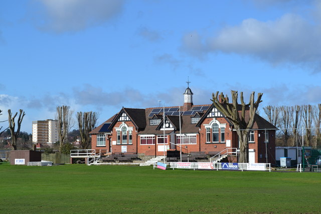
Stourbridge Cricket Club, War Memorial Athletic Ground, Amblecote, Stourbridge
The Cricket Club was established in 1842 and currently its
first eleven play in the Birmingham District League.
Between 1905 and 1981, the ground was used periodically
as a venue for Worcestershire County Cricket Club
The War Memorial Athletic Ground is also home to
Stourbridge Football Club aka The Glassboys in
recognition of the Crystal Glass Factories in the vicinity.
For more information and links to views of the Football Club see
SO8984 : Stourbridge Football Club - The Glassboys - War Memorial Athletic Ground, Amblecote, Stourbridge
The Tower Block to the left is located on Frimstone Street
For more views of the Cricket Ground see
SO8985 : Pavilion at Stourbridge Cricket Club, War Memorial Athletic Ground, Amblecote, Stourbridge
SO8985 : Flag Poles and Sign at Stourbridge Cricket Club, War Memorial Athletic Ground, Amblecote, Stourbridge
SO8985 : Scoreboard at Stourbridge Cricket Club, War Memorial Athletic Ground, Amblecote, Stourbridge
SO8985 : Cricket Nets at Stourbridge Cricket Club, War Memorial Athletic Ground, Amblecote, Stourbridge
SO8985 : Sight Screen Wall at Stourbridge Cricket Club, War Memorial Athletic Ground, Amblecote, Stourbridge
SO8985 : Football and Cricket at the War Memorial Athletic Ground, Amblecote, Stourbridge
SO8985 : Turnstiles at the War Memorial Athletic Ground, Amblecote, Stourbridge
 Map © Crown Copyright")
TIP: Click the map for more Large scale mapping
- Grid Square
- SO8985, 144 images (more nearby 🔍)
- Photographer
- Terry Robinson (more nearby)
- Date Taken
- Thursday, 13 February, 2014 (more nearby)
- Submitted
- Monday, 17 February, 2014
- Subject Location
-
OSGB36:
 SO 8976 8504 [10m precision]
WGS84: 52:27.7923N 2:9.1287W - Camera Location
-
OSGB36: SO 8990 8500
- View Direction
- West-northwest (about 292 degrees)