What is orienteering?
Orienteering is an activity not dissimilar to geocaching. Both involve looking for hidden objects in the outdoors. Orienteers use a map, geocachers use a GPS. This cache involves a bit of both. At a normal orienteering event a club will hide orange and white flags in the woods with electronic checkpoints and take them away at the end of the event. At a permanent orienteering course (POC), the flags are placed on permanent posts so that you can practice your navigation and find the flags whenever you like.
The POC map of Trosley Country Park
I suggest you start at the the cafe in the park where you can buy the detailed POC map of the park. Or you can download and print the map yourself from the British Orienteering website for £1. To find the map visit the website, select Go Orienteering and drill down the section on permanent courses until you will find a map of the South East with a flag for Trosley Country Park. There is an extract of the map above. You don't have to use the map but navigation is easier with it because it is at a scale of 1:7500 and shows the location of the posts you need to find, as well as all the paths, ground features like ditches and the thickness of the vegetation.
The Cache
The cache is a small clip box big enough for swaps and trackables.
There are 25 POC control posts in the park but you only have to find eight of them in the suggested order in the table below. The listed coordinates take you to the first one. The posts look like the picture above, each has the number on the map so you know have found the right one. It also has 2 letters. When you find the post, note down the letters, turn them into numbers and add them together. For example post no 17 in the picture has the letters AL. This would be 1 +12 = 13.
Complete the following table
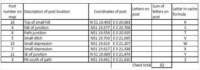
Use the letters in the right hand column to complete the formula to find the cache which is at:-
N51 (R+X) . X (S-V) (S-R) E000 (R+S-X) . T (X-W) (Z-Y)
I have not set up the coordinates of the posts as waypoints because it easy to see where they are on the map but I have given the coordinates so that you can find them with your GPS if you want to. Have a good hunt round and use the description in the table to help find them. Have fun.
If you want to practice map reading, the British Orienteering website has details of all the permanent courses in the country. More information on local orienteering can be obtained from the two Kent based orienteering clubs; Saxons OC and Dartford OK who put on regular events at which the general public are always very welcome.
Saxons Orienteering Club thank Kent County Council for permission to place the cache.