
This walk takes you through woods and fields with several ups and downs, to a lunch stop in Shamley Green. The walk was submitted by Guildford Rambling Club (see guildfordramblingclub.org.uk). Visitors to these walks are welcome.
1. Go out of the right-hand side at the back of the car park, up a slope and fork right to reach a road. Cross, jinking left to pick up a track, right, running away from the road and into trees. Walk through trees for just over ½ mile to reach another road. Along the way ignore a path right and pass Bentley Copse holiday site. At the road, go straight across into the side road opposite and immediately fork left onto a path labelled ‘Shere Manor Estate Welcomes You To Hurtwood’.
2. Ignore unsigned paths right and left and continue steadily down to reach a gate and beyond it a cross-paths. Continue forward and quickly reach a road. Go straight across to continue along the very wide track. At a yellow and blue arrow post, follow the yellow arrow right and up the very steep valley side. At the top, emerge at a T-junction with a very wide track with a timber yard to your right. Continue forward along the wide track.
3. Soon take a path forking right which dips down and then back up to rejoin the track. Continue forward. Go straight across a big cross tracks and again continue forward. Look for a footpath forking right and down into the next valley. At the bottom the path swings left and reaches a multiway junction at the end of the valley. Continue forward (left) into trees and keep going until reaching a road opposite the end of Jelley’s Hollow. Cross, jinking right, to turn left and follow the Greensand Way (GS) up into trees. This takes you away from the road and then swings right (west) roughly parallel to it.
4. Follow the GS arrows for about ½ mile, along the way passing through the back of Hurtwood car park number 12, to reach Hurtwood car park number 6. Don’t be tempted by the branches left that would take you off down a steep valley side. The GS takes you across the back of the car park then down to a road. Cross, jinking left, to turn right and continue forward. Pass a gate and then fork left at a 2-way signpost. Gradually descend. Go over a crossing track and continue to another cross-tracks. The signpost here points only left but should also point forward. Go forward, straight across. You are still on the GS.
5. Soon, reach a gate and, immediately before it, the GS takes you down to the left. Drop down a field towards a house and a lake. The path swings right and runs along the edge of the property and into trees. It reaches a T-junction where you turn right and then emerge on a drive. Continue forward (i.e. left) and quickly reach a road. Turn right, walk 100 yards and then take a footpath left, next to Stroud Farm. This is still the GS. Follow it until it passes a large house and reaches a T-junction with a lane. Turn left. Walk about 200 yards and then fork left, continuing forward to reach Shamley Green near the Red Lion and the green. For refreshments, you have the options of the Red Lion and the Bricklayers.
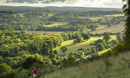
6. After lunch, walk towards the Bricklayers and the back of the green and take a narrow path, left, between Mellow House and the high Leylandii hedge of Summer Meadow. Follow this until it emerges on the tarmac lane that you traversed earlier. Continue forward to the far end of the lane and its T junction with a road. Cross, jinking left and taking a path climbing up to the right. Pass some steps and a gate on the right-hand side. Reach a cross-paths and continue on up the slope to reach a T-junction facing some barns. Turn right and take the track running along between fences. Soon look across to your left to see St Martha’s on the hill across a valley.
7. Follow the track for under ½ mile to reach a right turn through two gates to a road. Go straight across onto the wide vehicle track opposite, signed to Kilnhanger. Follow this track for about a mile passing Kilnhanger and also Mayor House Farm, ignoring lefts and rights and eventually reaching a road. Turn left and walk about 200 yards to a junction where the road turns sharp left. Here, at the start of Row Lane, turn right on a footpath between hedges and down a slope. At the cross-paths at the bottom go straight ahead and up a hill, Dick’s Hill, to cross a tarmac track and continue on down the other side. The path becomes very steep as you descend carefully to a deeply sunken path at the bottom.
8. Cross straight over the path, up over a bank. There is a gate immediately ahead but you turn left and walk across to the hedge to follow a path right and up a slope. Quickly reach a stile, left, and cross into a sloping meadow. Continue along the top edge of the meadow and, after 100 yards, go right and over a stile into a vineyard. Walk along the edge and, at the other side, go over a stile and turn right. Follow the path down to climb over a stile by a large wooden gate and into woodland. Immediately reach a T-junction with a track and turn right. Quickly reach a fork with yellow and blue arrows. Choose the left fork and walk with a wire fence on your right-hand side. Soon you are walking beside a large grassy meadow with good views of the North Downs.
9. At a large wooden gate, ignore a footpath on the left and keep straight on. The path continues past Knowle Farm and its house, over to your right. It then zigzags onto the concrete drive by Hound House with its long converted barn and reaches a road by the hound-pillared entrance gate. Turn right on the road and, because of the blind bend, walk on the left. After 100 yards, turn left through a metal gate into a meadow, now with houses of Peaslake visible ahead. Avoid the wide track half-right across the centre and instead take a grassy path running along the left-hand side of the meadow.
10. After a small metal gate, the path runs beside a field. Another small metal gate is followed by another field, after which you emerge in a lane. Turn right to walk along the lane and for some 250 yards until you see a path forking off left. This cuts off a corner and takes you down to the starting car park.

DISTANCE: 8.5 miles
OS MAPS: Explorer 145 Guildford & Farnham and also Explorer and 134 Crawley & Horsham
STARTING POINT: The Walking Bottom car park, about 250 yards along the road running West between the Hurtwood Hotel/Inn (GU5 9RR) and the church in Peaslake.


