 MERTON HISTORICAL SOCIETY
 Abbey Roads: a modern pilgrimage
 by W J Rudd
William John (‘Bill’) Rudd was born in Brixton, south London, in 1925. But in 1930, when he was five, the family moved to Morden (now in London but then in Surrey) to a house in Easby Crescent on the London County Council’s new St Helier Estate. He was educated at one of the Estate schools, leaving at the age of 14 to work at Liberty’s silk-printing works in Merton. After service in the Army from 1943 to 1947 he returned to Morden and joined the postal service, in which he spent the rest of his working life. He remained on the Estate, moving into a flat in Glastonbury Road after the deaths of his parents. Bill died at the end of October 2014 at the age of 89.
Bill had many interests, including archaeology, science, classical music, steam engines and steam organs, photography, cycling, and Youth Hostelling. However his great Project, as he called it, was a historical one. When it dawned on him that most of the Estate’s roads were named after British monastic sites, he conceived the idea of visiting every one of these sites – 108 of them – photographing them and learning what he could about their histories. He would do most of the travelling by bike, he would stay at Youth Hostels, and he would have to fit his journeys into the Post Office holiday schedules. It would take years. It did – it took from 1951 to 2003.
Abbey Roads is Bill’s own account of his Project, which he based on his diaries and notes, and this has been illustrated with his fine photographs. As well as many happy discoveries, friendly encounters, and enlightening moments, it tells of mishaps and frustrations endured and overcome. It is an extraordinary document.
Extracted from the back cover of the book
Click here to view Bill’s photographs of the abbey sites he visited.
ABBEY ROADS
A Modern Pilgrimage
Published by
MERTON HISTORICAL SOCIETY
2015
© Merton Historical Society 2015
ISBN 978 1 903899 71 7
Printed by intypelibra
Units 3/4, Elm Grove Industrial Estate, Elm Grove,
Wimbledon, SW19 4HE
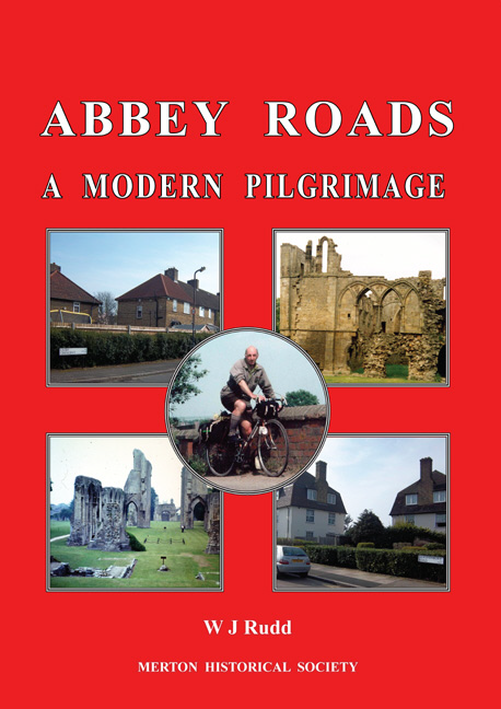
Cover photographs:
Top left: Easby Crescent, Morden Top right: St Agatha’s Abbey, Easby
Centre:
The author at the River Brant Bridge, Lincolnshire, 4 July 1979
Bottom left: Glastonbury Abbey Bottom right: Glastonbury Road, Morden
ABBEY ROADS
A Modern Pilgrimage
W J Rudd
(19 September 1925–30 October 2014)
Edited and photographs selected by Merton Historical Society’s editorial committee
MERTON HISTORICAL SOCIETY
ABBEy RoAdS: A ModERn piLGRiMAGE
EDITORS’ PREFACE
The St Helier housing estate, which extends from Morden to Carshalton, was built by the
London County Council during the years 1928 to 1936. Bill Rudd moved with his parents and
sister to a newly built house on ‘the Estate’ in 1930 and continued to live on the Estate until his
death in 2014.
The London County Council named virtually all of the roads on the Estate after monasteries,
mostly in England and Wales but with a few in Scotland. This principle of naming the roads
slowly dawned on Bill Rudd during his holidays from 1951 onwards, touring Britain as a Youth
Hosteller with his bicycle and camera. He eventually made it his project to visit and photograph
the remains of all 108 abbeys and priories that gave their names to roads on the St Helier Estate.
The bulk of these project visits took place between 1951 and 1969, although revisits to obtain
better photographs continued until 2003. Bill made other Youth Hostelling holiday trips with
his bicycle further afield to Ireland, The Netherlands, Belgium and Norway and has recorded
these in this book as well.
Generally, factual information has been recorded as it was at the time, for example, Ministry of
Transport road numbers and the names of counties and their boundaries.
In the principal reference(s) to each monastic site the name is given in bold.
All photographs reproduced in this book were taken by or for Bill Rudd, except as indicated on
page 71.
A Note on Youth Hostelling
The Youth Hostel movement was founded in Germany in 1909 by schoolmaster Richard
Schirrmann (1874–1961), who opened the first permanent hostel in 1912. The first British
Youth Hostel opened in Wales in 1930, and more rapidly followed. The primary aim was to
provide cheap and healthy holidays for young people, but in fact there was (and is) no age limit.
Each hostel was run by a warden, male or female. Hostellers slept on bunk-beds in dormitories,
men’s or women’s. Food, where provided, was wholesome and substantial. Tasks such as laying
and clearing tables, washing up, and sweeping floors, were shared out. There was usually a
small store with basic provisions, and there was a kitchen for the hostellers’ use. Hostels were
closed from after breakfast to late afternoon. Hard luck if you arrived early and it was raining.
The ‘hand-stamps’ that Bill mentions are traditional rubber stamps used with an ink-pad. Each
hostel has its own emblem, which can be printed on the hosteller’s membership card.
Though there are still a few ‘simple’ hostels today, most now offer good cooking, wine and beer,
and freedom from chores. Some have family accommodation. And you can even arrive by car!
Note:
£1 = 20s (shillings) = 8 half-crowns = 240d (old pence) = 100p (new pence)
1 mile = 1760 yards = 1.6km (approx)
1 yard = 3 feet = 0.914m
CONTENTS
MAP: LOCATION OF MONASTIC SITES vISITEd ………………………………………………….6
MAP: THE ST HELIER ESTATE ………………………………………………………………………………8
1. HOW IT STARTEd……………………………………………………………………………………………..10
2. THE SLOW dAWN – 1951, 1952 …………………………………………………………………………15
3. EUROPEAN INTERLUdE – 1953, 1954 ………………………………………………………………25
4. THE dAWN BREAKS – 1955 ……………………………………………………………………………..30
5. THE TRUTH OF THE MATTER – 1956, 1957 ………………………………………………………44
6. THE PROJECT – 1957…………………………………………………………………………………………47
7. dISASTER – 1957 ……………………………………………………………………………………………..62
8. THE PROJECT – 1958 ………………………………………………………………………………………..65
9. A MIXEd BAG – 1959 ………………………………………………………………………………………..72
10. THE PROJECT – 1960 ………………………………………………………………………………………79
11. INTERLUdE – 1961………………………………………………………………………………………..101
12. THE PROJECT – 1962……………………………………………………………………………………..104
13. THE PROJECT – 1963 …………………………………………………………………………………….119
14. THE PROJECT – 1964 …………………………………………………………………………………….133
15. THE PROJECT – 1965 …………………………………………………………………………………….142
16. THE PROJECT – 1966 …………………………………………………………………………………….159
17. THE PROJECT – 1967, 1968…………………………………………………………………………….171
18. THE PROJECT – 1969 …………………………………………………………………………………….181
19. TOWARdS THE ENd ……………………………………………………………………………………..189
INdEX OF ABBEYS ANd PRIORIES……………………………………………………………………197
Location of monastic sites visited
1 Abbotsbury Abbey2 Aberconway Abbey3 Alnwick Abbey4 Bardney Abbey
Battle Abbey6 Bayham Abbey7 Beeleigh Abbey8 Bindon Abbey9 Blanchland Abbey
Bodmin Priory11 Bordesley Abbey12 Boxley Abbey13 Bristol Abbey14 Bruton Abbey
Buckfast Abbey16 Buckland Abbey17 Burnham Abbey18 Bury St Edmunds Abbey19 Calder Abbey
Canterbury, St Augustine’s Abbey21 Cartmel Priory22 Cerne Abbey.70
23 Chester Abbey24 Combermere Abbey
Crowland Abbey26 Croxden Abbey27 darley Abbey28 dorchester Abbey29 dore Abbey
Easby, St Agatha’s Abbey31 Egglestone Abbey32 Evesham Abbey33 Faversham Abbey
.45
.51
97.
•
43
3.
66•
40.
.
9
85•
•
….31
31313131
•
19
30•
ABBEy RoAdS: A ModERn piLGRiMAGE
•
104
68 Osney Abbey69 Owston Abbey70 Paisley Abbey71 Pershore Abbey72 Peterborough Abbey73 Pipewell Abbey74 Quarr Abbey75 Revesby Abbey76 Rewley Abbey77 Robertsbridge Abbey78 Roche Abbey79 Rushen Abbey80 St Alban’s Abbey81 St Benet of Hulme Abbey82 Sawtry Abbey83 Selby Abbey84 Shaftesbury Abbey85 Shap Abbey86 Sherborne Abbey87 Shrewsbury Abbey88 Sibton Abbey89 Stavordale Priory90 Stoneleigh Abbey91 Tavistock Abbey92 Tewkesbury Abbey93 Thornton Abbey94 Tintern Abbey95 TitchfieldAbbey96 Torre Abbey97 Tweeddale Abbey98 Twyford Abbey99 Waltham Abbey
100 Welbeck Abbey
101 Wellow Abbey
102 Wendling Abbey
34 Flaxley Abbey
35 Furness Abbey
.79
36 Garendon Abbey37 Glastonbury Abbey38 Halesowen Abbey39 Hartland Abbey40 Hexham Priory41 Humberston Abbey42 Hyde Abbey
.
2
43 Kelso Abbey44 Keynsham Abbey45 Kinloss Abbey46 Kirkstead Abbey47 Langdon Abbey48 Leominster Abbey49 Lesnes Abbey50 Lilleshall Abbey51 Lindores Abbey52 Llanthony Prima Priory53 Llanthony Secunda Priory.105
54 Malling Abbey55 Malmesbury Abbey.63
56 Marham Abbey57 Meaux Abbey58 Merevale Abbey59 Milton Abbey60 Missenden Abbey
.39
61 Montacute Priory62 Muchelney Abbey63 Neath Abbey64 Netley Abbey10•
91…96
.
65 Newhouse Abbey1615
66 Newminster Abbey67 Newstead Abbey (Priory)
•
21
35•
57•
83•
65…
93101
41•
.78
.100
•
4
.23
46..75
.24.67
50.26
•
26
87
..27
58..36
.69
38•
.106
.73
.90
11•
48.
9271
..
•
32.108
52…107
•
76
2934•
..53
..60
68
94•
80
•
•
13.55
.28
17..
98
.
44
37..
•
89
14•
84
.42
.86
62.
.64.
•
95
61.22.59
.1
.
8
.74
103 Westminster Abbey104 Whitby Abbey105 Whitland Abbey106 Wigmore Abbey107 Winchcombe Abbey108 Woburn Abbey
•
2556..81.
102
.72
.82
88•
.18
7.
.103
.49
•
33
54..12
.
.
20.47
.77
.
ABBEy RoAdS: A ModERn piLGRiMAGE
The St Helier EstateGeographers’ 4-Sheet Map of
sectionThe St Helier EstateGeographers’ 4-Sheet Map of
sectionThe St Helier EstateGeographers’ 4-Sheet Map of
sectionThe St Helier EstateGeographers’ 4-Sheet Map of
sectionThe St Helier EstateGeographers’ 4-Sheet Map of
sectionThe St Helier EstateGeographers’ 4-Sheet Map of
sectionThe St Helier EstateGeographers’ 4-Sheet Map of
sectionThe St Helier Estate
detail from Geographers’ 4-Sheet Map of
Greater London, SW section c.1950
The St Helier Estate
detail from Geographers’ 4-Sheet Map of
Greater London, SW section c.1950
The St Helier Estate
detail from Geographers’ 4-Sheet Map of
Greater London, SW section c.1950
ABBEy RoAdS: A ModERn piLGRiMAGE
1. HOW IT STARTED
My first sight of the London County Council St Helier Estate came when, together with my
young sister and me, my parents moved from Brixton to Morden on 27 October 1930. There,
on the Estate, which was still under construction, we were allocated No.15, a new-built three-
bedroom, mid-terrace house in the centre of Easby Crescent, which had a clear front view up
Egleston Road. Because I had passed my fifth birthdayI was in the first admissions to the Surrey
County Council new-built No.2 School in Canterbury Road, which opened on 10 November. I
passed in three-year stages through the Infants, Junior and Central Boys’ departments, leaving
school on 22 december 1939, with a war in progress.
Immediately after Christmas I was employed at the Liberty & Co silk-printing works in Station
Road, Merton, and worked in several processing departments until I was conscripted into the
Army at the end of November 1943. After four years, serving both at home and abroad, I was
demobbed in the autumn of 1947. Under the Reinstatement Act I could have been given a
job at the factory, but I changed my mind and joined the GPO as a postman, which had better
prospects for the future.
It was my friend George Shave, who lived next door at No.17, who taught me how to ride a
bicycle in the late summer of 1938. In January 1939 he received a new bicycle for his birthday,
and I was able to buy his old one, third-hand, for two shillings and sixpence (12.5p), from his
father. Together we explored the highways and byways of Surrey, even when, with the threat
of war, all the direction signs and other aids to location were removed and hidden away in case
of invasion.
On my birthday in September I received a new bicycle, a BSA roadster (my sister got one in
december), from Norry’s, a local cycle shop. Unfortunately it was stolen on 29 July 1940 in an
unguarded moment. In October I opened a Post Office savings account, and with diligent saving
I managed to buy a Rudge Whitworth roadster, £7 12s 11d, plus insurance, on 21 June 1941.
It was to serve me well through the war years, including 20 months serving as a Civil defence
messenger from April 1942, and on leave from the Army, and after. In the meantime my mate
George suffered severe illness and was never to ride again.
It was through George that I met John Barr, who wore a green triangle badge, and he told me
that he was secretary of the Wimbledon local group of the Youth Hostels Association. Suitably
encouraged, I joined the YHA in September 1948 – and lost out on the three months of autumn
that would have been added to the 1949 membership had I joined in October; and also the
subscription went up! I would defer joining the local group for the time being.
The single-speed Rudge had managed a day return trip to Bognor Regis on the Sussex coast,
a distance of more than 90 miles. What I needed was a new bike, with gears. The pre-war
proprietor of Norry’s mixed goods shop was Mr Norrington, with Mr domsalla, who dealt with
cycle matters in the back of the shop. In post-war years Mr F v domsalla took over the business
and produced his own cycles under the initials AKd – his wife’s, as she was the secretary. At
his suggestion I sent a letter to Hobbs at dagenham for information on bicycles they produced.
The reply contained both the details and a specification form, which was then filled in and sent
off on 30 October 1948 with £2 0s 0d deposit.
The order was for a made-to-measure Hobbs of Barbican ‘Clubweight’. It would have an all-
welded frame of Reynolds 531 tubing, fitted with Maes bend drop-handlebars and cable brakes.
1. how iT STARTEd
The front wheel would have a dynohub for lighting. The rear wheel would have a Sturmey-
Archer 4-speed wide-ratio hub gear – 44.3, 52.5, 66.4, 84. Low enough to climb hills and high
enough for fast travelling. The frame would be green enamel – to match the countryside!
It arrived on 8 January 1949 and cost £29 9s 7d, which included insurance. I was all set. The weeks
that followed were trial runs to get used to it, especially the gears. At John Barr’s suggestion
my first hostel was Ewhurst Green in Surrey, which was visited mid-week in February during
my winter leave in the Post Office. The hostel was fine, and the warden, Mrs Crouch, provided
the supper and breakfast I had ordered. Unfortunately I was the only one booked in, and the
weather was wet. Not a very good start. Things did improve at the weekend when I visited
Kemsing hostel in Kent, where I had company.
I joined the Wimbledon local YHA group on 31 March, their Thursday social evening. As it
was a mixed ballroom and folk dance session I was readily welcomed. They met at Queen’s
Road School. They were a mixture of cyclists and walkers, though most did a bit of both. At
weekends they went hostelling or day events. But there was a snag. Come Easter and on Bank
Holidays, parties went off on Friday and returned on Monday. I could not join them as, being a
postman, I had to work on Saturdays. Henceforth I would go it alone as a solo tourist. This had
the advantage of doing what I liked. What followed was to be a revelation. The cycle rides, the
rambles, the wide variety of hostels, the visits to places, and the celebrations like Halloween,
fireworks and New Year parties. And there was the companionship.
It would be useful at this point to understand the Post Office leave system. The summer leave
was from April to September and was divided into periods of two weeks each. Postmen were
divided into groups. The leaves were organised into two rotations, thus giving each man an equal
share. The leaves could be exchanged by arrangement. The winter leave was from October to
March, with the dates listed. Leave was chosen by seniority and length of service. I had five
days in February. There was a gap of one week between summer and winter and vice versa. The
duties of men on leave were covered by reserves.
I have no idea what my group number was. It just so happened my summer leave was on the
last two weeks of September. I had no specific plan in mind, but I did have three objectives, and
my routes were planned accordingly. I left home on Monday 19 September, and my first stop
was Cambridge Youth Hostel. In the evening I went downtown and ordered a drink at the house
of Commons public house. When I said I was celebrating my 24th birthday I got the drink free
on the house. After King’s Cliffe (Northants.) my next hostel was Lincoln, where I arranged to
meet Leslie Pearson, my first objective, at a chosen spot. We had served together with the Army
abroad. Now, two years after demob, it was pleasant to meet him again.
The next hostel was 77 miles away in York. I did have an invite to lunch at doncaster. I met Mr
Roy Roberts next to the racecourse, who had his young son sitting on a crossbar seat. When we
reached his home I met his wife. Mrs Roberts was, before marriage, dorothy Shave, George’s
elder sister who lived at Easby Crescent. So it was a jolly meeting, with talk about old times.
It was my second objective completed. We made an appointment to call again on the return
journey. Needless to say, the rest of the ride to York was in good spirits.
After York I headed for the coast and stopped at Bridlington hostel. Then up the coast road to Filey,
where I hoped to see George at the holiday camp there, but had no luck with the third objective.
The week ended at Whitby hostel, high above the town. It is approached in two ways. One is up
the 199 steps from the harbour. The other is by a minor road, leaving the A171 at Stainsacre.
ABBEy RoAdS: A ModERn piLGRiMAGE
From the beginning I had collected postcard photos or drawings of the hostels I visited, and
put the dates on the back. Hostels without cards I photographed and had postcards made.
Whitby hostel did not have a card and was almost impossible to photograph. As a consolation
I photographed the ruins of Whitby Abbey in the mist. Of some interest, supper, bed and
breakfast cost four shillings and sixpence.
The return to York was across the Yorkshire Moors. This proved, quite literally, the high spot
of the tour. After York I had another delicious lunch with the Roberts family in doncaster. And
at Lincoln a farewell drink with Leslie Pearson, though I was later to visit him and his parents
many times. There was so much to see in Lincoln city.
The route from York via Lincoln to King’s Cliffe hostel was the reverse of the outward one.
New to cycle touring, I was playing safe. I did however divert to the final hostel, at Saffron
Walden, Essex – a very ancient building with oak beams and a courtyard garden to match. The
village got its name from specialising in growing crocuses. A delightful end to a first tour.
Apart from the pannier frame slipping on the journey to Cambridge, and having to be re-fixed,
the tour was a success. The Sturmey-Archer bottom gear had managed the 1 in 8 gradients
with a full load when crossing the moors. But the year was not without problems. There were
a number of back wheel spoke breakages. The wheel was rebuilt with thicker gauge double-
butted spokes. The gear trigger control kept slipping out of bottom gear and had to be held
down with the thumb. Apparently there were two sets of springs in the gear, which created
considerable tension in the wire. The trigger was replaced. The cyclometer, which recorded the
miles, failed and was replaced with a spare, creating a double calculation. The Burlite brakes
were also replaced. On the good side, the Hobbs had covered 100 miles on a day tour of Herts,
and 110 miles on a day tour of Kent. In the main it had done well. By Christmas it had reached
my projected target, with 5002 miles.
The maps I used were the new post-war Bartholomew’s revised ‘half-inch’ contoured series.
As I did not have a complete set for the tour my fellow cyclists in the Wimbledon YHA Group
came to my aid and filled the gaps. We operated a private arrangement, which was an invaluable
saving on the cost of new maps. We chose the linen-backed dissected variety, for hard wear, at
five shillings each.
In 1950 my winter leave was again in February. I had already planned what to do with it, but
now I found there was a General Election in the middle of it. So I devised a figure of eight, or
rather rough conjoined triangles, using five hostels at the points, and home as a base crossover.
The first point was 75 miles north-east to Colchester, Essex. The second was 56 miles west to
Puckeridge, Herts. Then a fast ride south through London to Morden, where I cast my vote
and had lunch, followed by an afternoon run south-west to Holmbury St Mary, Surrey. Total
70 miles. Then north-west to Henley on Thames, Oxon 45 miles. South again to Hannington,
Hants. 50 miles. Finally to Morden, another 70 miles.
By now I was fully integrated with the boys and girls in the Group. I use the terms in the broadest
sense. My first hostel weekend as leader was 25/26 March, to Blackboys in Sussex, but I could
only persuade two boys to join me. In the event it turned out very well. We had fine, warm,
sunny weather. On the Sunday we went down to Eastbourne, where we were photographed on
the Esplanade by a freelance photographer. The postcard I still have is a pleasant reminder. Then
it was a climb up the South downs at Beachy Head to see the Belle Tout, an old lighthouse, the
site of which was being considered as a possible hostel, which did not materialise. Finally, after
1. how iT STARTEd
lunch, we had a look at the Long Man of Wilmington, a tall figure cut in the chalk. We all agreed
it had been an enjoyable ride throughout the weekend.
In June I joined the Group for another visit to the Sussex coast, staying overnight at Patcham
hostel and spending much of Sunday exploring Brighton, until it was time to move on. I was
about to pick up my bike on the Marine Parade when I slipped and fell heavily on my left side.
Fortunately there was a St John first aid post nearby where they put my forearm in a splint
and took me to the Royal Sussex Hospital. There they put me under anaesthetic while they
straightened out the impacted fracture of the radius. Afterwards a member of the group escorted
me with the bike to the railway station. I arrived home in time to find a party in progress to
celebrate the christening of one of my nieces.
Just over six weeks later, during which I was still able to take part in various other activities, I
was back in the saddle. On Sunday 13 August I joined the Group cycle ride to St Albans, where
I was able to take a fine photograph of the cathedral from the well-worn viewpoint. As I was still
on sick leave from work I put in some more exercise by travelling down to Canterbury hostel,
and the next day crossed Kent and Sussex to Arundel hostel. A total of 176 miles, to put me in
trim for my summer leave.
By arrangement my summer leave was in September again. It was planned on a grander scale
than the first one. I chose the Isle of Man and the Peak District. I started by joining the Group
hostel weekend to Streatley. Then in stages reaching the delamere Forest (Cheshire) hostel.
despite an early start next morning and using the Runcorn-Widnes transporter bridge, I missed
the morning ferry, owing to headwinds.
The afternoon ferry took four hours to cover the 70 miles across the Irish Sea to douglas, Isle of
Man, arriving in the evening, but in plenty of time to cover the 8½ miles to Ballasalla hostel in
the south part of the island. I spent three days alternating between Ballasalla and Andreas hostel
in the north. I devoted much of the limited time to covering as much as possible. This included
the whole of the coastline from Point of Ayre in the north to Port St Mary in the south, as well
as criss-crossing the interior – in the process scaling the heights of Snaefell, 2034 feet.
The island has very attractive cottages, villages and coastal resorts, such as Port Erin, Castletown,
and Ramsey, as well as douglas. Peel, with its ruined castle, has always been the headquarters
of the Manx fishing fleet. On the way round, waiting
at a level crossing, I got a brief glimpse
of the quaint locomotive and train of the Isle of Man steam railway, but failed to see a stubbin
(Manx) or rumpy (English) Manx tailless cat. There was the Manx lady who tried to teach me
the local dialect, unsuccessfully, and told me what I must do when crossing the Fairy Bridge,
1½ miles from Ballasalla on the road to douglas. very respectfully I said ‘Good day’ to the
‘Little People’. As it turned out I needed all the luck I could get.
I left Andreas hostel knowing I would not catch the morning ferry to Fleetwood (Lancs.). The
distance was too great. The distance between douglas and Fleetwood is 56 miles. With time on
my hands I called in to Flinn’s Noted Manx Kipper Curers in douglas and ordered a box to be
sent to me on the date I reached home. I still have the receipt.
Although the ferry crossing was shorter, it still took the scheduled 3½ hours to do it. At Fleetwood
I could have cut down on the distance to Longridge hostel, but chose instead to follow the coast
south to Blackpool to see the famous display of lights. I found it a fantastic sight. Then it was
on the A583 to Kirkham and Preston, and I picked up the B6243 to Longridge. I arrived half
ABBEy RoAdS: A ModERn piLGRiMAGE
an hour after closing time – 10.00pm! Luck was on my side, and the Warden let me in. I said,
with some truth, that the ferry was late. I went to bed in the dark so as not to disturb the others
in the men’s dormitory.
Next morning I set a course skirting the northern parts of the Peak district. I stopped at
Bradford for lunch before diverting to Ossett, which, together with Bradford and Leeds, was
where I was stationed in the army during the war. Then down to Holmfirth hostel. This is where
the real challenge started, but in the event there were only two climbs over the moors of any
consequence. The rest was following the river valleys in between. It included the sight of the
very impressive Ladybower Reservoir (derbyshire).
The rest of the tour was quite straightforward, until I came across a standard but very tall road
direction sign near Princes Risborough in Buckinghamshire. It had three arms stretched out at a
forked road junction. And each arm bore the same number – B4444! The photograph I took of
it was published in the CTC Gazette.
In the Wimbledon YHA Group there was a growing interest in collecting as many different
hostel rubber hand-stamps as possible. My own growing list now included the two Manx
hostels–a definite cachet in my favour. There was also keen competition to be the first to visit a
newly-opened hostel. I managed it in the next weekend after the tour, by visiting Bradwell-on-
Sea, Essex. It may only have been a collection of old converted ex-wartime RAF huts, but it did
have a remarkable survivor of the Saxon period, a little over a mile away on the coast. This is
the chapel of St Peter ad Murum, Bradwell-Juxta-Mare, built by St Cedd, c.654. Although now
diminished to a blocked-off east end of the nave of the original building, it stands preserved
without any changes except a replacement west door lintel. Completely bare inside, but with a
simple altar, crosses, candles and flowers at the east end, it is a very peaceful place. It stands on
the site, long vanished, of a Roman fort,
To conclude. Other hostels visited in 1950 were Crockham Hill, Goudhurst and High Halden, all
in Kent. There were pyrotechnics at Tillingbourne and a long run of working parties at Chaldon
in Surrey. One of a set of photographs entered in the London Region reunion competition, at a
penny each, won first prize
of a guinea (£1 1s 0d). It was quite a year. But now a change was
about to take place.
2. ThE SLow dAwn – 1951, 1952
2. THE SLOW DAWN – 1951, 1952
Now that I had experienced the sense of adventure and the feelings of pleasure of cycle touring,
I decided to divide the country into areas and deal with each in turn, but on a broad scale, with
a view that in the future I would select a smaller area and explore it in greater detail.
The winter leave 19–25 February 1951 I ventured into East Anglia, covering Essex, Suffolk
and Norfolk. Despite the vagaries of the weather (most of the 74 miles from Nazeing, Essex,
to Finningham, Suffolk, was done in pouring rain), it had its bright moments, and was quite
pleasant. This area is especially interesting for its timber and thatched cottages, the windmills,
and the variety of its churches, in particular those that are flint-faced, which includes the round
towers – and thatched or tiled roofs.
The East Anglian coastline was not neglected. Starting at Sheringham, a seaside resort, I
travelled down to Cromer; the shoreline suffers from sea encroachment. Then down to the
seaport and herring-fishing town of Great Yarmouth,
famous for its dried herrings known as
‘bloaters’. It has a safe anchorage for shipping. Its parish church is one of the largest in England.
After leaving the Youth Hostel I continued south to another popular seaside resort, Felixstowe.
After that it was cross-country and back over the county boundary between Suffolk and Essex
for the journey home. 376 miles.
In addition to the fascination of parish churches, particularly if I can get inside and buy a guide
– not always possible – there is the attraction of the great cathedrals, Canterbury, Lincoln,
Lichfield and St Albans; and those that were approaching completion, Liverpool and Guildford,
the twentieth-century cathedrals, one dating from 1904 in traditional Gothic, the other dating
from 1936, described as ‘an effective simplification of Gothic forms’. Both were effectively
delayed in construction by war. All of these I had seen on my travels.
Until now I had not come across much in the way of monastic remains, the only exception being
in the 1950 tour when I had a look at the extensive ruins of Grace dieu priory in Leicestershire.
For me it was just one of the several places I visited or things I saw and photographed as a
sample of something to remind me of the tours I did and look back on in later years.
At Whitsun I decided to spend a hostel weekend to cover some of west Kent and Sussex. I
would use the newly-opened Cudham hostel, though it still needed a few finishing touches.
I calculated the ride would take under two hours. With few exceptions all the hostels closed
between 10.00am and 5.00pm to give the warden a rest before the next intake. I would use the
afternoon to tour Kent.
The first encounter on the way out, bypassing Cudham, was Lullingstone. It had a small
medieval church, St Botolph, an 18th-century house called Lullingstone Castle and a medieval
gatehouse. All rather strange. I learnt later that the house contained both Tudor and medieval
elements, so the appellations had some validity. A short distance away is the site of the Roman
villa, a protected ancient monument in the care of the Ministry of Public Buildings and Works
(abbreviated MPBW). As time did not permit the detailed study I felt it deserved, I decided to
leave it for another day, and continued the ride, reaching Cudham hostel in the early evening.
Next morning I set out for Sussex, crossing the Kent/Sussex border at Bayham Abbey. This
is also a MPBW property. I paused just long enough to photograph the bridge and entrance to
ABBEy RoAdS: A ModERn piLGRiMAGE
the site before continuing the journey south. The first objective was Bodiam Castle, a National
Trust property. Built in 1385, it really is very imposing, standing as it does foursquare in a large
moat. While the exterior is largely intact, the interior is a hollow shell. It still has a medieval
atmosphere about it, and has been used in films.
The next objective was Battle, named after the famous battle of 1066 between William the
Norman and King Harold the Saxon. The outcome was a Norman king, who founded, in 1067,
the Benedictine abbey dedicated to St Martin. It was another king who was responsible for the
Dissolution in 1538. Much of the abbey has disappeared, but there are sufficient remains for
visitors to see. You can stand where it is alleged King Harold fell, and look down the slope of
the hill where the battle took place. The town which grew up on the site is now surrounded by
farms and woodland. It has a parish church, St Mary, 1775, and a railway station. It was a very
satisfying weekend.
30 June–1 July I joined some of the Wimbledon group cyclists on a hostel weekend to Goudhurst
hostel, Kent. The hostel is south of the village, which stands on a hill. Of genuine antiquity, it
is datable to the late 16th century, and its true identity is found in the hand-stamp ‘Twyssenden
Manor’. Chaldon hostel, Surrey, is even older – Tollsworth Manor having dendro-dated medieval
features. The only thing of note on this weekend was the visit to Bayham Abbey, where I was
able to see more of the ruins and take some photos (below).
I think it was about this time that I had a feeling, albeit rather vague, that the visits to Bayham
Abbey might be the start of something, though I could not put a finger on it. But there was a clue.
As a postman I knew the names of all the roads in the Morden postal district where I worked, as
they were listed alphabetically with their walk (delivery) numbers on long boards fixed above
the inward sorting frames. And one name was Bayham Road. So what was the connection?
2. ThE SLow dAwn – 1951, 1952
Among what could be called miscellaneous names were three distinct groups: the Tudor group,
the West Country group and the St Helier Estate group, which was large, and extended into
neighbouring Carshalton. Clearly there was a lot more to be done to find the answer.
For my summer leave I set my sights on the West Country – Cornwall, devon, Somerset and
dorset – by travelling through Hampshire and Wiltshire. It was to be a comprehensive tour. To
add a little light relief, if I passed through a town or village whose name was represented by
roads in Morden, I would send a postcard to a colleague at work whose delivery it was. Four
postcards survive, dunster, Holne, Kingsbridge and Thurlestone, which I retrieved when I got
back. After the successful visit to the Isle of Man the previous year, I would try to fit in a brief
visit to the Scilly Isles. As I could only spare two days, the concentration would be on the main
island, St Mary’s, as it would take a week to explore all the islands. I arrived at Penzance hostel
and, after locking my cycle away, I arranged with the warden to borrow a small rucksack for my
essentials, as well as book an early breakfast, in order to catch the ferry, the Royal Mail steamer
Scillonian, which would leave for St Mary’s at about 9.30am depending on the tide. The voyage
would take approximately 3¼ hours.
No advance booking was necessary, and I got a period return for 25 shillings. The ship arrived at
the quay at Hugh Town in the early afternoon. I just managed to get one night’s accommodation
at a small boarding house before setting off on my first walk, having obtained the standard
guidebook, which contained a mine of information and a map of the Scilly Isles. It had a useful
large-scale folding map which enabled me to explore the area to the west of Hugh Town known
as The Garrison, which contained Star Castle, constructed in 1593 as a defence against Spain,
still at war with England after the defeat of the Armada (1588), and which still contains some
old cannon. I made a start on Peninnis Head before going back to my lodgings.
The next day I went back to Peninnis Head to see a rather unusual lighthouse. Built in 1911
of iron and standing on legs, it is 45 feet high, is not manned, and gives a white flash every
20 seconds. I then walked round Old Town Bay, past the airport, which has a regular service
with Land’s End airport, and worked my way up the east side to reach the top of the island at
Bar Point. Many of the rock formations have curious names. With occupation going back to
distant prehistoric times there is evidence everywhere, such as Bant’s Carn, a hollow stone-
roofed chamber. It was now time to get back to Hugh Town, passing the golf links and down
the west side, to have a look round the town, the only one on the island. The houses are solidly
constructed of grey granite, as is the Post Office; it is the natural geology. There are all the
requisite shops, banks, a hospital and a cinema. There is a wide variety of activities. After a
good look round I went down to the quay to catch the ferry.
The RMS Scillonian left St Mary’s for Penzance at 4.15pm, but arrived late after a rough
crossing, too late for me to pick up the cycle and take up my booking for Land’s End hostel. So
I spent another night at Penzance, and handed back the rucksack. In the evening I checked the
map for the next day’s journey and reflected on what had gone before. The visit to Launceston
Castle, a MPBW
site, the ride along the causeway off Marazion to photograph St Michael’s
Mount, and a hasty return as the tide was coming in.
Off next day to Land’s End, then up the coast as far as Hayle, and across to Camborne (card
sent to Morden Postmen’s District Office) before arriving at the newly-opened Truro hostel.
The next objective was Plymouth. On the way I stopped at Bodmin for lunch. Although it
is a West Country town it does not fit into the West Country group in Morden. It is a part of
ABBEy RoAdS: A ModERn piLGRiMAGE
the St Helier Estate group as Bodmin Grove. At this stage I have to say that my mind was a
complete blank as to its significance. I had stopped there for tea on my way down to Lostwithiel
hostel the previous week. However, things were about to improve.
Most hostels have information of one sort or another on local attractions. It is possible that this
set me on course for a visit to the National Trust property of Buckland Abbey (devon) the next
morning. The site is approached along a country lane and down a winding, sloping drive to the
group of buildings set up the side of the valley of the River Tavy. What was once the abbey
church has long been converted to a mansion, and is now a museum maintained by the city of
Plymouth, and contains the famous drum. Its most famous resident was Sir Francis drake, and
descendants of the family, through his younger brother, survived down the centuries. Now I had
to climb back up the drive and get on with the ride. I finished up at Salcombe hostel, but not
before collecting cards from Thurlestone, Kingsbridge and the town of Salcombe, and posting
them off. The hostel was two miles south-west of the town and 429 feet above, at the east end
of three miles of National Trust protected coastline, and had splendid views.
I was off in the morning
down the hill to take the
Salcombe harbour ferry
across the Kingsbridge
estuary. Then a
cross-country route
northwards, turning
west from Totnes for
lunch at Buckfastleigh.
Afterwards I visited
Buckfast Abbey
(right). Built by
the monks on the
foundations of the
former medieval
monastery over a
period of some 30
years, it is a magnificent
achievement. It is open
daily all year, and
services are open to
the public. It provides
refreshments, gifts and
souvenirs, as well as
the famous Buckfast
honey, and tonic wine.
(I bought a bottle from
a local off-licence when
I got home, and it really
is very nice.) The wine
is imported, to which
the monks add their
own ingredients.
2. ThE SLow dAwn – 1951, 1952
A minor road leads from Buckfast Abbey to Holne, on the east edge of dartmoor National Park.
The attractive church of St Mary the virgin is spoilt by a rather plain tower. The village’s claim
to fame is that it was the birthplace in 1819 of the author Charles Kingsley. Not far away is a
wooded area called Holne Chase (another road in Morden). I found my way back to the main
road at Ashburton and set out for Exeter, where I was able to see the cathedral, before going to
the hostel.
I left Exeter via the A30, which follows part of the Roman road to Bath, as far as Honiton, noted
for its lace, then climbed up the heights above the River Otter, to reach the junction with the
A303, continuing in an eastern arc to Ilminster. Then on to Petherton Bridge where it picks up
another length of the Roman road. But I turned off onto the A3088 to Montacute (Somerset),
my objective for the day. I acquired a little booklet which gave details of a gatehouse, a mansion
and the parish church. The gatehouse (below), a fine example of architecture, together with a
large 358-nest pigeon-house, are all that are left of the Cluniac priory, founded in 1102 and
under the direct rule of Cluny in France, which received a portion of the rents. But, following
the wars with France, the ‘alien’ monasteries came into the king’s hands. Montacute Priory
claimed independence from Cluny in 1407 and continued its existence as an English monastery.
It was finally dissolved in 1539. It was the third owner of the site, Thomas Phelips, who built the
Tudor house. Later members of the family enlarged the house, and in 1931 it was purchased by
the National Trust. Many of the family are buried at the parish church of St Catherine. Probably
standing on the site of an earlier one, the church is medieval and has a fine Decorated tower. The
day continued with a triangular route east to Yeovil, north to Ilchester, down the Roman road,
before branching off to the newly-opened hostel at Martock.
ABBEy RoAdS: A ModERn piLGRiMAGE
The last three days of the tour continued to provide a great deal of interest in the towns and
villages I passed through, as well as the varying countryside while slipping through the county
boundaries of Somerset, dorset, Wiltshire, and Hampshire, until reaching the more familiar
territories of Surrey. The visits to the three monastic sites which are represented by the St Helier
Estate roads, while being of more than a little interest, did not add anything to what I was to
call ‘the slow dawn’, other than the sky had brightened a little. There was still a long way to go.
during the summer months a list of the dates of the winter leave went up on the notice-board in
the office, and I signed for the last period, 24–29 March 1952, as being hopeful of fine weather.
But then, just before Christmas or soon after, the list for the summer leave went up and I found,
after three Septembers, one on schedule and two exchanges, that my group was listed for the
first two weeks, 7–20 April 1952. It was an opportunity too good to miss. So I went to see the
inspector in his office and put a strong case for moving my winter leave into the gap. Highly
irregular, he said, but agreed it would not make any difference to the running of the office – so
I got it. This long three weeks was to be ‘the big one’. I would do a round tour of the British
Isles – England, Scotland, Ireland (both parts) and Wales. I set to work at once to draw up plans.
I already had the 1952 handbook and a map of all the hostels in England and Wales. I sent off
for those in the Scottish YHA, YHA Northern Ireland, as well as An Oige, the Irish YHA. I
had to round up all the maps I needed. I had my own collection of Barts half-inch. Wimbledon
Group members filled some of the gaps, but I had to buy any extras. Then there was the Irish
quarter-inch series. Next came the booking of hostels, knowing there would be some off-peak
closures, and the busy Easter weekend. Scottish YHA had only one open, Cargen (dumfries).
There would be two changing points, one at Rockliffe Youth Hostel, Cumberland, and the other
at Pentre-cwrt Youth Hostel, Pembrokeshire. A parcel which contained a change of clothes
and the maps for the next stage would be sent to the hostels in advance. I arranged for the Post
2. ThE SLow dAwn – 1951, 1952
Office to send my wages by postal draft to be cashed at the local post office. Finally, the cycle
would have an overhaul, and I would also purchase enough films for the camera.
It was a cyclist member of the YHA Group who recommended me to join the Cyclists’ Touring
Club, founded in 1878. I was formally accepted on 26 June 1949 with all its benefits. To this I
added membership of the National Trust, February 1952, and at the same time got a card from
the Ministry of Public Buildings and Works, which would give me free entry to NT and MPBW
properties and save money.
After work I spent the weekend in preparations for the tour. Unfortunately the weather was
not what I wanted. Snow had fallen. I left home early and faced snow and sleet showers on the
first stage to Cambridge hostel. There was one-way traffic and drifts up to seven feet in parts
of the county, but by the time I reached Lincolnshire the snow had cleared. This gave me the
opportunity to visit and photograph the ruins of Bardney Abbey (foot of facing page). Two
days later I reached Yorkshire, where I came across a direction sign pointing to Easby Abbey,
an exciting moment. A MPBW site, it had splendid ruins, in good preservation (see pages 167–9).
Not far distant to the north was Egglestone Abbey (below), another MPBW site, beautifully
kept. The close proximity of the two monastic sites matched the juxtaposition of Easby Crescent
with Egleston Road (a modified spelling).
The journey northward continued after I left Barnard Castle hostel (Co. durham). Reaching
Carlisle brought back memories of the wartime blacked-out train ride from Euston, arriving
at 7.00am and waiting all day and night before the next move, to Northern Ireland to start
army primary training. I then reached Rockliffe hostel (Cumberland), where I carried out the
changeover and cashed my postal draft. Although a fairly short distance of 46 miles to Cargen
SYHA I had a much longer distance to travel next. I was the only one booked at Cargen,
ABBEy RoAdS: A ModERn piLGRiMAGE
self-cooking only but had enough in the hostel store for an evening meal. I left early next
morning and decided to leave breakfast until some stop on the way. I found what I wanted at
the Stewartry dairy at dalbeattie, which set me up for the long journey. Scotland is reckoned
to be two weeks behind, weatherwise, the south of England. A sight of a sheep with two lambs
showed spring had arrived. I reached Stranraer (Galloway) after 82 miles in time to board the
night ferry to Larne (Co. Antrim).
My first two days in Northern Ireland gave me the opportunity to revisit those places that were
a part of my 15 weeks there in the army, which came to nothing when I caught bronchitis.
Ballykinlar camp (Co. down), where it started, and Bangor and donaghadee where I recovered.
I had to do it all over again in Bradford after leave. But now I was on holiday, and a fund of
experience awaited me.
The description ‘Emerald Isle’ holds good, as it does appear to have a particular shade of green.
The Mountains of Mourne in County down really do sweep down to the sea at one point. One
of the things about cycle touring is you do get a clear unhindered view of the changing scenery
and all the buildings. You can stop to have a look at something that catches the eye. In Ireland
there were the many castles, and one particular cottage with a thatched roof, extended front and
all the walls covered in seashells in a wide variety of patterns.
The people on both sides of the border were very friendly. Indeed, as no passport was required,
a cheery wave from the Irish customs was all that was necessary. I met some Irish lads and we
had a jolly day, which included a visit to dunbrody Abbey (Co. Wexford). The hollow shell
of the church is largely intact and there are extensive remains of the cloisters. In the evening
we joined forces for the meal. All the hostels I booked were self-cooking only. While post-war
rationing was still in force in Northern Ireland, there was none in An Oige, in neutral Eire,
where the food was plentiful but expensive.
2. ThE SLow dAwn – 1951, 1952
The last hostel was Arthurstown (Co. Wexford). With funds running low, the urgency was to
book the night ferry from Rosslare, which I did after leaving in the morning, and spent the rest
of the day pottering around Wexford until the evening. The ferry reached Fishguard at 7.00am
and I was allowed to stay on board until the customs were ready, and this time it was rather
more official. I soon got away and the rush was on to reach the hostel at Pentre-cwrt, where
I completed the second changeover and cashed my postal draft. I now had enough to see me
home.
The last stage through Wales and beyond was to provide some surprises. Not the run from
Pentre-cwrt to Crickhowell (Breconshire) and to St Briavels Castle – which is a castle of special
architectural or historic interest (and boasts a ghost!), but the penultimate day from St Briavels
Castle to Marlborough. A few miles south of the former is Tintern Abbey (Monmouthshire),
a MPBW site (foot of facing page). After crossing the Beachley–Aust ferry over the River
Severn (the Severn Road Bridge now crosses the estuary at this point), a distance to the east is
Malmesbury Abbey (Wilts.) (below). Both feature on the St Helier Estate. A close inspection
of the map disclosed many more. It was increasingly clear there was a connection. I would find
time to visit London County Hall and find the answer. After I left Marlborough I took a very
long route to the south-east to Milford hostel in Surrey, where the Wimbledon YHA group had
spent the weekend, and I came home escorted in triumph after a distance of 1316.9 miles.
The year was nowhere near over. After a long-distance run to Colchester Youth Hostel, on
Sunday 1 June I set out to visit Beeleigh Abbey (Essex) and took a photograph of the entrance
(see page 30). It is open to visitors on Wednesdays. On the way to doddington hostel on 19
July, a brief visit to Malling Abbey, Kent, pausing at the entrance for a photograph (overleaf,
top).
ABBEy RoAdS: A ModERn piLGRiMAGE
Another winter leave in November and a visit to the Isle of Wight to photograph Quarr Abbey
(below). The total of monastic sites was rising. Just how many roads on the St Helier Estate
were named after monasteries? I would have to check. There must have been a reason for it.
3. EuRopEAn inTERLudE – 1953, 1954
3. EUROPEAN INTERLUDE – 1953, 1954
On the whole 1952 had been a successful year, but with more than a touch of sadness. My
father had died following a fatal road accident. I would have to support my mother, though she
had received some compensation. His Majesty King George vI had also died and his daughter
Elizabeth was now Queen. Preparations for her Coronation were well in hand.
There was a matter I simply had to attend to. Until now all my photographs had been taken
with a Kodak Six-20 ‘Brownie’ box camera, which I had bought in 1946 in a NAAFI (Navy
Army and Air Force Institutes) shop while I was serving in Nigeria, West Africa, with a fixed
lens which had a slide for close-ups, and a single exposure of 1/25th of a second. In spite of its
limitations it had produced some excellent pictures. It was now time for a camera with better
facilities. I found what I was looking for in a recently opened shop in Morden Court Parade,
Graphic Studios. The proprietor showed me the latest product.
A full description would not come amiss. It was an Ilford 35mm Advocate Camera – Series 2.
As described in the brochure ‘It is not a copy of a camera of foreign origin but represents a new
development native to this country’. In its specification ‘it is fitted with a Dallcoated (bloomed)
dallmeyer Anastigmat F3.5 lens of 35mm focal length … The body is a pressure die-casting of
aluminium silicon alloy and the finish of the outer surface is hard stoved ivory enamel.’It had
shutter speed and lens aperture controls, a focusing mount and a facility for flash photography.
Price £24 16s 11d. The ever-ready leather carrying case and lens hood came extra. A
filter
mount was available. I loaded an Ilford HP3 hypersensitive panchromatic film and took a set
of ten wide-ranging subjects. Back at the shop the film was cut out, developed and half-plates
printed. The results were impressive. The remainder of the film was put back in the camera.
For some time now members of the Wimbledon YHA group had been hostelling in Europe.
They asked me the question, ‘When are you going?’. The fact that I’d served in the Army in
Europe did not count. The opportunity came when I picked up some literature advertising a
‘Wimpeltocht’, a pennant tour of the Netherlands. What better choice for a cycling holiday? I
wrote to the Nederlandse Jeugdherberg Centrale, the dutch Youth Hostels Agency, NJHC, and
received the booklet containing details of the Zuider Zee Pennant Tour, the route, with some
variations, and the six checkpoints I had to pass through to get a hand-stamp. Also the list of
Youth Hostels. I bought the necessary Michelin maps to plot the route. Then I had to book the
hostels, using International vouchers. I would start after the Coronation on 2 June 1953, which
I saw on my sister’s television. Two days later I was on the train from Liverpool Street station
to Harwich for the ferry Mv prinses Beatrix to the Hook of Holland.
There is no room for a detailed account, so I will settle for the highlights. The use of cycle tracks
is compulsory and cyclists are well catered for. I set out straightaway for the first hostel on the
coast, Loosduinen, where I received a warm welcome. The dutch are very friendly. English is
their second language. Next day through den Haag and across to Sloten, west of Amsterdam, to
pick up the tour route. North-west to Spaarndam to see the statue of Pieter, the ‘boy who saved
the dyke’, the legendary figure who stopped a flood by sticking his finger in a hole. North up
the coast to Bakkum hostel. In the process I missed the sight of the cheese market at Alkmaar
held every Friday.
I passed through the town next day and set a zigzag course to the Ijsselmeer, the inland lake
formerly the Zuider Zee. volendam welcomes visitors where many of the local people wear
the traditional costume of that particular district. Through Edam (my favourite cheese) and
ABBEy RoAdS: A ModERn piLGRiMAGE
northwards through the Polders, reclaimed land, to the next stop at Oosterland, ready for
crossing the Great dyke the next day.
The Great dyke, Afsluitdijk, is a monumental feat of engineering. 30 kilometres (18 miles)
long, it serves as a barrier between the salty North Sea and the fresh water of the inland lake,
which boasts a fishing fleet. Locks each end are for shipping and helping to drain water. Ideally
you cross with the prevailing south-west wind. It is an incredible experience, with the buildings
disappearing below the horizon behind you. It’s like riding a never-ending pier, with the cycle
tracks and road going on forever, until, at last, buildings appear in front of you. A classic
example of the curvature of the Earth. At the far end I turned left up the coast, turning right at
Harlingen and down across the countryside, literally sprinkled with windmills, to reach Sneek
Youth Hostel.
The route from Sneek to Meppel took me through a vast area of lakes and watercourses of every
description, which compared with the giant north-east Polder, the work of the assiduous dutch
in reclaiming land from the inland lake. The scene changed when, travelling south, I reached
the Hoge veluwe National Park, and visited the Rijksmuseum Kroller-Müller. Here displayed,
together with other artists, is a collection of masterpieces of van Gogh. I spent the night at
Arnhem hostel. The town had been restored after the ravages of war. The next day I called at
Nijmegen where I had spent the odd day out from my unit in Goch, Germany. I then set out on
the long run to Amersfoort, the next hostel.
In the morning I had enough time to visit the busy market before a look at the 328-foot (100m)
high 15th-century Gothic tower, all that remains of a church destroyed in 1787. It has a fine
carillon, a large set of bells struck by hammers from a keyboard. The next stop was Utrecht,
which also has a tower, the domtoren. At 367 feet (112m) high it was formerly linked by an
arch to the nave of the cathedral, which was destroyed in 1674. It stands opposite the preserved
nave. The tunes played on a carillon are a delight to listen to. Then off again for Amsterdam via
Hilversum, the noted broadcasting station. I was nearing the end of the tour.
I spent much of the morning exploring Amsterdam as well as visiting the Rijksmuseum, a
vast place, which has several rooms devoted to Rembrandt, and the van Gogh Museum with
its collection of paintings, drawings and letters. Finally to the tourist office for the last of my
six hand-stamps. They gave me a pennant to put on the cycle. The tour was over. I set out for
Loosduinen Youth Hostel where I came in.
It had been a satisfying experience, though foreshortened by four days. The film I was using
was also foreshortened, so I went into a shop in volendam and bought another one. I declined
an invitation by the proprietor to be photographed in dutch costume with his pretty assistant.
There was a horrifying moment when I saw my cycle chained with others being hoisted across
the dock at the Hook of Holland to the ferry. Fortunately I got home safely.
1953 ended on a high note. We had a Queen on the throne. People settled down to a new
Elizabethan age. It was time to get back to my interest in the monastic road names on the
St Helier Estate. But then something else caught my eye in the London YHA
shop, a leaflet
advertising ‘Blossom Tours in Norway. May 1954. A Fortnight’s YH Holiday for £15’. This was
too much to lose. It was run by the Bergen Line. They were not conducted tours, you travelled
independently. The tour charge of £15 included return steamer passage, tourist-class cabins for
4, 6 or 8 persons, and vouchers covering the cost of ten bednights, supper and breakfast. Other
3. EuRopEAn inTERLudE – 1953, 1954
meals you paid for separately. For an extra £2 I could get a 2-berth cabin. There was a list of
hostels that would accept the vouchers, but outside the designated area you would have to pay
the hostels.
My plan had been to circuit from Bergen to Stavanger. Unfortunately my summer leave dates
made it impossible, so it was out and back along the chosen route. The cycle was given a
thorough check and fitted with a larger sprocket on the back wheel which lowered the gears.
I would be facing mountains. I booked the hostels of the Norge Ungdomsherberge, and the
return passage on the MS Venus, with the Bergen Line. There was one problem. My new 35mm
camera had to go in for a minor repair, and was not ready on time. So I had to take the box
camera with several films. I left King’s Cross station for Newcastle on Monday 17 May. Unlike
the Dutch ferry, where I had to pay a fee for my bicycle, an officer on the gangplank of the
Norwegian ship said, ‘No charge, just lock it up on the lower deck’.
The night crossing was calm and peaceful and I had enough time for breakfast on board before
having a good look round Bergen. The town has much to offer. What I needed was a guidebook.
I would ask the warden at the Youth Hostel for advice. To reach the hostel I had to travel on
the Fløiban, the funicular railway up the cliff behind the town. It climbs 1000 feet in eight
minutes to arrive at Fløyen high above Bergen. The view from the top is superb, with the town,
harbour and fjord spread out below. I was warmly received by the warden, and discovered quite
a number of hostellers from groups in London were there. Most appeared to be set on walking
in Norway. I was the only cyclist. Supper followed, and I spent time afterwards studying the
map I bought in Stanford’s mapsellers in London. It had been published by the KNA, the Royal
Automobile Club of Norway, and distributed by Geographia Ltd. It was a super map.
The next morning I took the Fløiban back to ground level and set about the first stage of the
tour. As expected in a mountainous country, roads are rather spread out, twisting and turning,
following fjords and rivers. I discovered some rivers drop down waterfalls, and roads have to
climb up to the upper level. The extra-low gears came in handy. Not unexpectedly daily mileage
was on the low side, under 50 miles to the next hostel, Kvamskogen. Unwittingly I found
myself having supper with other people when I should have been with the hostellers. There was
no harm done. It was an open help-yourself table spread.
Thursday, and I found myself facing my first climb at Tokagjelet, 454 metres (1490 feet), before
dropping down to Øystese on the banks of Hardanger Fjord. Then followed the road to Kvanndal
to catch the ferry Folgefonn to Kinsarvik, which stopped at Utne on the way. The road alongside
the Sorfjord led to Loftus hostel, where I had a surprise.
A large party of schoolgirls with their teacher had arrived by coach from Haugesund. As it
turned out, the teacher Brita Stangeland taught English, and I found myself the prime target for
practice. In the morning they told me they were going to Kinsarvik, and would pick me up on
return and take me part of the way on the next stage of my journey. And so it was. The loaded
cycle was hung on the large hooks on the front of the coach and I settled down to the ride.
We stopped at Odda for refreshments, then they dropped me off at Steinaberg bridge where
we parted and they set off for Haugesund. I now faced the remainder of my journey to Røldal
hostel.
The climb commenced at once. Long gradients stretched before me. vegetation got sparser
and snow appeared, getting deeper all the time. An avalanche shelter had thick ice, and cycling
became tricky. Eventually the snow formed high walls on each side of the road. This was the
ABBEy RoAdS: A ModERn piLGRiMAGE
work of the large snowplough I had seen which cut through the snow and hurled it up on the
side. Roads at lower levels were surfaced. On the mountain passes they were left bare. Tall
poles marked the line of the roads to be cleared. I reached the height of 1065 metres (3494 feet),
before dropping down to Røldal. Nine miles up, five miles down. Time – one and a half hours.
Røldal is a thin scatter of buildings set in a sloping valley down to Røldalsvatn Lake. These
mountain settlements can only be described as hamlets. As I was now out of the voucher limit I
had to pay, which I had done already. This also applied to the next hostel at Grungedal. The last
outward stage was to be the real test.
It started off with a road near a river, then a right turn to climb up to Svandalsflona reaching a
height of 1148 metres (3767 feet), followed by another climb to 1552 metres (5092 feet), before
a drop of 980 metres (3215 feet) at Haukeliseter, where I stopped for a much needed break. At
this height the lakes were still frozen over, the mountains eerily silent, conjuring up thoughts of
trolls of Norse mythology.
As part of my preparations I had packed a small Primus stove, a screw-top small kettle and a
mug and teabags. I set up for lunch on a long seat at the end of one of the buildings, and settled
to eat my packed lunch sandwiches washed down with refreshing neat tea. It attracted two small
children, particularly the boy. His older sister soon lost interest. I took some photographs of
them, as it was a delightful meeting to treasure. The rest of the journey was to follow a long line
of small lakes, each linked by a river.
I spent two nights at Grungedal using part of my rest day looking round, and cleaning dirt off
the cycle chain. The warden informed me that I was the first tourist and cyclist to come through
the pass that season. I had accidentally left my YHA card at Røldal, so I put two hand-stamps
on a piece of paper to stick on the card when I went back and prepared for the return. As I knew
what to expect I decided to take it more leisurely. Little did I know I would get another surprise.
On the return to Haukeliseter I set up my stove again, but was interrupted by a gentleman from
across the road who asked if I would like to have lunch with him. I was very pleased to accept
and packed my things away. Inside the house I was surprised to see the children again. After the
meal we had a pleasant conversation, during which I explained how I came to be there. I had to
leave to face the high pass again, so I thanked him for his hospitality. I spoke to two men who
were working inside the building where I had left my cycle. They told me the man I had lunch
with was Knut Haukelid, a former resistance leader in the war. He had just written a book called
Skis Against the Atom. I would buy it when I got home. The top of the highest part of the pass
has the boundary marker between the Telemark and Hordaland fylker, i.e. counties. From there
on it was down to Røldal.
Five days before I had cautiously descended the winding road to the valley. Now I had to climb
back up again, a toilsome business. Once over the top it was a clear run to Steinaberg bridge
and a gentle ride to see the giant waterfalls, the Låtefoss and viefoss. Past Odda I had a better
chance to look across the Sorfjord at the snow-topped Folgefonn glacier. And so back to Loftus
hostel.
The Kinsarvik–Kvanndal ferry this time was the hardangerfjord. The next hostel was at
Øystese, then Kvamskogen, and finally Bergen. At the hostel I explained to the warden that by
going outside the voucher zone I had three not used. He said he would take them in exchange
for a selection of pottery he made. I was delighted to accept his offer. I chose some small glazed
3. EuRopEAn inTERLudE – 1953, 1954
pots and dishes. I learned more about Bergen and what to see. The early morning market – fish,
fruit and flowers. Two old churches and the cathedral. The museums and variety of architecture.
The Hardangerfjord lived up to its name, with the fruit trees in full May blossom. Norway’s
national musical instrument is the eight-stringed Hardanger fiddle.
Before I left I visited the crafts shop Husflid and bought a traditional jumper, hat and scarf. The
bill reads 108 Kr 25 øre. Then back once more on the night ferry. I discovered, too late, when
I caught the train from Newcastle, I was a day over my leave. So I told my inspector to take a
day off my winter leave.
Once home I wasted no time in buying Knut Haukelid’s book from Foyles’ shop in London. It
proved to be exciting reading. As I had exchanged addresses with Brita Stangeland I wrote to
ask her if she could forward the book to the author. I was most excited when it came back with
his autograph. I considered myself most fortunate in having met him and his delightful children
Knut junior and Kirvil, his sister.
I offer no excuse for breaking off my interest in the monastic road names of the St Helier Estate.
The opportunity to travel abroad was there, and I knew I would never get another chance. It
was an experience I could not afford to miss. But, a week before I left for Norway, I joined the
Wimbledon YHA group on a hostel weekend to Oxford. On the journey out I snatched a chance
to photograph Dorchester Abbey (Oxon) (below), then raced to catch them up.
ABBEy RoAdS: A ModERn piLGRiMAGE
4. THE DAWN BREAKS – 1955
I got off to a good start on returning to the monastic project in the spring of 1955. On 21 May
I joined some of the Wimbledon YHA group cyclists in a hostel weekend to Goudhurst, Kent.
The leader took us on the usual route.
On Sunday we set off on a different, more leisurely, route during which we visited Bayham
Abbey. This was my third visit (see pages 15&16), so I had the chance to take another photograph
for my collection. At Tunbridge Wells we had a look at the stone formation nicknamed the Toad
Rock.
On 2 July I set out on a solo ride to Maldon hostel, Essex. This placed me in a position to revisit
Beeleigh Abbey (below) to improve on a photo taken with the box camera in 1952. On the ride
home I stopped to look at the church of St Andrew, Greenstead-juxta-Ongar, which has Saxon
timbers on the nave wall. It is remarkable.
The following weekend I cycled as far as Chatham, Kent, then got a train to Canterbury and the
hostel. Less than an hour to Faversham. The next morning I reached the town and asked where
Faversham Abbey was. When I found the place, or what purported to be the site, all there was
to see appeared to be a length of stone wall. The end of a nearby house also had some of the
same stone.
This was going to be a problem in the future: scanty or no visible remains. I would not be
deterred, and set about my summer leave in September.
4. ThE dAwn BREAkS – 1955
When I passed through Wales in 1952 I had promised myself to go back and explore more of it.
At the same time I would visit as many monastic sites as possible.
During my period on substitute duty, which had startedin August 1953 and finished in February
1955, I had delivered in, and had a detailed knowledge of, all the roads in Morden. My married
sister lived in Shrewsbury Road. As a consequence I learned a lot more of the St Helier Estate
in Carshalton.
With all this accumulated information I knew what to look for. The slow dawn was about to
break.
I set out early on Monday 19 September, my thirtieth birthday, and headed for Burnham in
Buckinghamshire, and sought out Burnham Abbey. I discovered it was a nunnery, revived in
1916. I took two discreet photographs from just inside the entrance (below). I had a long way
to go, passing through Oxfordshire to Wiltshire, to reach the hostel at Ashton Keynes, a total
distance of 90 miles.
This put me in a position to pay a second visit to Malmesbury Abbey (overleaf, top) and take
two more photos, before heading west to cross the River Severn on the Aust–Beachley ferry,
and stop at Chepstow hostel, in Monmouthshire. Looking at the tiers of brown contours on the
map in the evening, it was clear there would be a lot of climbing to do. And so there was.
I took the lower road from the hostel and I was soon climbing up a minor road to reach 370 feet
and rising to reach Shirenewton. Then a short crossover to pick up the B4235 and continue to
climb to a crossroad at 685 feet. A weaving ride between high peaks before a steep drop to lower
levels at Llangwm and on to the river and town of Usk.
ABBEy RoAdS: A ModERn piLGRiMAGE
It was a pleasant ride through the
Usk valley in close proximity to
the river, and at one point I had
the company of the railway on the
run into Abergavenny.
From there I picked up the A465
to stop at the Skirrid Inn at
Llanvihangel Crucorney. I was
now on track, literally, for my
target.
I followed the vale of Ewyas
alongside the Afon Honddu to
Llanthony Priory. The standing
ruins comprise the west front, the
lower arcade of the nave (below),
part of the tower, transepts and
presbytery – the latter three dating
to the 12th century. It was a house
of Augustinian canons. The site
was immaculately kept by the
Ministry of Public Buildings and
Works.
4. ThE dAwn BREAkS – 1955
I continued up the narrow lane and turned left onto a grassy track to reach the heights of the
Black Mountains. By propping up my camera and setting the delayed-action device I took a
photo of myself and cycle (below). From Rhiw Y Fan, 2032 feet, the ridge drops sharply. I
followed the track down and round, to reach the A4078 to Talgarth. From there it was a fairly
straightforward run to Brecon, turning left two miles out to reach the Youth Hostel Ty’n-y-Cae,
the Welsh description of the place (‘the field house’). The converted Victorian house was set in
a sloping ground surrounded by trees and greenery.
Leaving Brecon behind me, I now faced the Brecon Beacons. After five miles on the A470 I
turned off on an undulating road to Heol Senni. Then a valley and a zigzag up to the high point
of the road, Maen Llia, 1468 feet. The road then dropped for several miles before reaching the
vale of Neath, at the southern end of which was the MPBW site of Neath Abbey (overleaf).
I was amazed at the size of the site. Although I was able to go in, the nearby hut was closed,
so I could not get a copy of the official handbook. However, once I found the layout of the
monastery church, the rest of the ruined buildings fell into place, the cloisters etc. In rather dull
weather I took four photographs and made a note to return in future. From Neath I took a route
west and north of Swansea and down to Cillibion Hostel in the Gower peninsula.
Next morning I took the coastal route round the Burry inlet and at Llanelli picked up the A484,
which was to take me the rest of the way. I took the opportunity to visit the MPBW property of
Kidwelly Castle. Built in the 13th century by the Normans as one of a series of strongholds, it
survived down the centuries until the ruins were taken over in 1927. I reached the county town
of Carmarthen, and after a weaving valley road and more climbing I arrived at Pentre-cwrt
hostel, which I had previously visited in 1952.
ABBEy RoAdS: A ModERn piLGRiMAGE
One of the interesting, and indeed essential, things in Wales is the double spelling of the
counties and some towns, in English and Welsh; thus Carmarthenshire reads Sir Caerfyrddin.
‘Sir’ equals ‘county’.
It was the boundary between Carmarthen and Cardigan I crossed the next morning. At Llandysul
there was more climbing, from 652 feet to 975 feet, before dropping down to reach the coast
at the town and seaport of Aberaeron. From then on it was a pleasure to follow the coast road
beside Cardigan Bay, with just one ridge, which provided excellent views of the coastline and
the country inland, before the market town and summer resort of Aberystwyth. The day finished
at Borth hostel, close to the dunes and sandy beach. It would have been nice to stay longer, but
I had a long journey ahead.
I got away as early as possible in the morning, stopping only as long as necessary to take a
photo of the incredible clocktower at Machynlleth, and loading another film. Then pressed on
up the dovey valley to turn onto the A470. Although it followed a seemingly valley route of
several rivers between the high peaks it rose at one point from 397 feet at Llanbrynmair to 730
feet at Talerddig before dropping down. The railway line that ran close by had to find its own
level. It was Sunday, so no trains. At Caersws I turned onto the A492, which led to Newtown,
Montgomeryshire. More hilly bits on the A489 through Kerry, Sarn and Churchstoke to cross
the border at Snead into Shropshire. On through Lydham to Craven Arms, where the A49 took
me to Ludlow. Over 81 miles.
Stopping at Ludlow had put me within an hour’s ride of Leominster, Herefordshire. This gave
me plenty of time to look for the monastic site, which turned out to be the parish church,
dedicated to Saints Peter and Paul. According to the pocket guide it was a Benedictine priory
founded in 1130, and dissolved in 1539. What survives is the original Norman north nave and
4. ThE dAwn BREAkS – 1955
north aisle; a later south nave and south aisle; the west end; tower and south porch. The east
end was blocked off after demolition of the rest of the monastery. The whole is protected as an
ancient monument. I decided one photograph (above) would be enough, at least for the time
being, as I needed to conserve film. One thing I did find interesting was the ducking-stool I saw
when I first reached Leominster. It had a fascinating history, and a verse, on a board. It was last
used in 1809.
Shortly after I left Leominster on the A44 I stopped for a moment to look over the parapet of
Steens Bridge station. The double track was still in place, but one platform was bare and the
other had a forlorn small building. Clearly the branch line was closing down, something which
was becoming commonplace.
An undulating route took me through docklow, Bredenbury and Bromyard before crossing the
county boundary between Herefordshire and Worcestershire. The county town of Worcester is
famous for its blue porcelain ware and other industries, particularly gloves.
After six miles on the A422 I turned off through Flyford Flavell and dunnington to reach Broom,
in Warwickshire. The Youth Hostel, Broom Hall, is of genuine antiquity, and is described as a
timber-framed building on a stone floor, and contains elements dating from the 15th to the 17th
centuries. It had to be carefully adapted in modern times as a 60-bed hostel. This placed me in
an excellent position for what was to follow.
It was run by a husband and wife jointly as wardens. A friendly couple. In the morning, come
closing time, the husband had business to attend to. His wife set to in the front garden, where
I met their delightful little daughters, Josephine and her sister, Pauline, in a pram. I sent copies
of the photos I took of them.
ABBEy RoAdS: A ModERn piLGRiMAGE
At Bidford I joined the A439, and almost at once I came across a large collection of old
steamrollers and steam ploughing engines, in the yard of Bomford and Evershed Ltd. What
would become of them, I wondered, either scrap or preservation. At Norton I joined the A435
direct to Evesham, Worcestershire, and looked round for the abbey. I found a rough stone
pointed arch and a length of wall (below). The gateway was barred, so I was unable to see what
was beyond. There was no one around I could ask for directions. So I took a photo and rather
reluctantly left. I would try again.
The A44 north-west led no great distance to Pershore, where I found the abbey, or what was
left of it. I managed to get a handbook which gave me the essential details. A religious house
was founded in 689. The Benedictine order took over after 984, and the Saxon church was
replaced by a Norman church in 1090. Over the centuries it was added to and altered, with
much rebuilding after two disastrous fires. After the Dissolution in 1539/40 the parishioners
were unable to purchase the whole church, but redeemed the monastic portion, rather than the
nave which had been their own place of worship. The rest was destroyed and became a quarry
for other buildings. The parts that survive include the crossing, with the bell-tower and south
transept, and the presbytery with central sanctuary and side chapels. What was left of the site of
the north transept became the vestries. Photographs in the handbook show how magnificent the
church is. As the west side of the tower had nothing to support it, two modern buttresses are in
place. In rather dull light I photographed the south-west of the church, and the surviving cloister
arch, just when the sky brightened (facing page).
I took the A4104 out of Pershore and then branched off onto the A4080 to Eckington. The road
passes the great height, the 848-foot Bredon Hill, to reach Bredon village. Soon after I arrived
at the market town of Tewkesbury (Gloucs.), with its magnificent abbey church.
4. ThE dAwn BREAkS – 1955
ABBEy RoAdS: A ModERn piLGRiMAGE
According to the guide, a small monastery appears to have been founded in 715 as a priory. It
suffered in the civil and danish wars, and was re-founded c.980 as a cell. It then became the
Benedictine abbey of St Mary, in 1102. It has a most remarkable history, involving a great many
families. At the Dissolution in 1540 the whole was sold off, and demolition began. The citizens
of Tewkesbury petitioned that the church might be saved, and were able to purchase it for the
sum of £458. It still stands proud (below).
South of the town is the site of the Battle of Tewkesbury in 1471, when the Yorkists under
Edward Iv crushed the Lancastrians in Edward’s last battle of the Wars of the Roses.
To reach the fourth site of the day’s itinerary I had to take a route through Ashchurch, Oxenton,
Woolstone and Gretton, the latter part weaving between three great heights, to the village of
Winchcombe. What would I find there? After making enquiries, the answer was nothing. The
monastery had vanished from the face of the earth, so thoroughly had it been stripped. I found
someone who mentioned an arch. When I found it there was no indication whatever that it
was connected with the monastery. But I took a photograph of it – just in case. This was very
disappointing.
I had travelled eastwards from Tewkesbury to Winchcombe, which added extra miles, as I
needed to travel west to reach my destination. The A46 climbed over the height of Cleeve Hill,
dropping down to Cheltenham and Gloucester, where I picked up the A40.
I reached Huntley and turned left, winding through valleys on the A4136, with a sudden climb
to 579 feet to reach Mitcheldean Youth Hostel, after almost 70 miles. The hostel is close by the
ancient royal Forest of dean, and only a short distance from Flaxley and the abbey.
4. ThE dAwn BREAkS – 1955
On arrival next morning I was pleased to find a building there. In the booklet that I got, the
Cistercian Abbey of Flaxley, otherwise dene Abbey, or the Abbey of Blessed Mary of dene,
was founded by Roger, Earl of Hereford, after his father Milo FitzWalter was killed by an
arrow on that spot while hunting, on Christmas Eve 1143. The dates of foundation differ, but an
authoritative source gives the date 30 September 1151.
The building that survives is part of the west wing, apparently the refectory, datable to 1200.
Much altered over the years, particularly the windows in 1700, the interior has been restored to
its original form. To the south end over vaulted chambers is the 14th-century abbot’s guest hall,
though this had other uses before 1349 (below).
Considerable work carried
out in 1913 has provided sufficient evidence of the layout of the
church, chapter house and cloisters, as well as other parts, under the gardens. What was built on
the foundations after the dissolution in 1536 is not known. The refectory, still intact, served as
a ground plan for all building after 1600.
In the charter of Richard I the monastery was under the protection of the sovereign. King John
and Edward III paid visits for the purpose of hunting. Elizabeth of York, Queen Consort of
Henry vII, visited Flaxley in August 1502 during her progress to Wales.
It was time I made progress, and after taking two photographs I headed south on the A48 to
reach the Beachley–Aust ferry, and south again to Bristol. The cathedral is impressive and
warrants a deal of attention. Unfortunately, as always, time was the prime factor. A guidebook
would have to suffice.
ABBEy RoAdS: A ModERn piLGRiMAGE
The abbey was founded by Robert FitzHarding, reeve of the town of Bristol, afterwards Lord
of Berkeley, in 1140–42. It was a daughter house of the Abbey of St victor, Paris, of the Order
of St Augustine of Hippo, i.e. victorine. Its history is substantial. After dissolution in 1540, in
1542 Henry vIII created the Bishopric of Bristol and the abbey church became a cathedral. Of
the monastery, the church, chapter house and north cloister walk survive. The standing ruins
nearby are the remains of the bishop’s palace, destroyed during the pro-Reform riots of 1831.
In rather dull conditions I took a photograph of the north elevation from across College Green.
I must come again.
It was no great distance to the last visit of the day – Keynsham, to the south-east. It came as another
disappointment to find so little, or no, evidence. All I was able to photograph was a narrow lane
and the walls on either side, though one side did have an arch doorway as the only sign (below). I
continued on my way on the A4 to Bath Youth Hostel. What would I find tomorrow?
As it happened, it augured well. It was going to be a sunny day. I took a course down the A367
south-west to Radstock. Then west on minor roads through Midsomer Norton, Ston Easton to
Chewton Mendip on the climb over the Mendip Hills, up to 855 feet, past Pen Hill, 1000 feet.
After that it was a fast run to Wells. Less than six miles to Glastonbury.
On arrival I soon found the abbey site. The ruins are impressive, even though they are a fraction
of what was there originally. They date from the late 12th century and replace a former abbey
largely destroyed by fire in 1184. ABenedictine monastery was founded in 940. The whole site
is steeped in legend.
Those parts that survive include the western lady chapel; a short length of the south wall arcade
of the nave; the eastern piers of the crossing, with parts of the north and south transepts; the
4. ThE dAwn BREAkS – 1955
south wall of the choir, and
corner stumps of the east
end. The isolated abbot’s
kitchen is complete. With
so much to choose I took
a photo of the abbot’s
kitchen (right), and three
broad views of the ruins
(see front cover). And
saved the last exposure for
the 14th-century chapel of
St Michael on Glastonbury
Tor. And put in another
film.
I set out eastwards on the
A361, but soon broke off
to take a winding cross-
country course through
West Bradley and ditcheat
to reach Bruton. I was
disappointed yet again.
No one seemed to know
where the monastery
was. All I found was
an extremely high wall.
Considering Bruton was
only a small town, it
was, at least, unusual. I
took a photograph to be
on the safe side. South
then to Wincanton, North
Cheriton and Henstridge
to Marnhull hostel. I had
three more days and one
more site to go.
I left Marnhull and took the country route through the villages of Todber and Stour Row to
Shaftesbury (dorset), set on a hilltop, and soon found what I was looking for. The ruins of the
abbey church of the virgin Mary and St Edward, King and Martyr, are an Ancient Monument.
The Benedictine abbey was founded by King Alfred the Great and consecrated in 888 as a
house of nuns. His second daughter, Ethelgiva, became abbess.
Edward, son of Edgar by his first wife Ethelflaed succeeded his father in 975 as a young boy.
His stepmother Elfthryth, third wife of Edgar, plotted his murder in 978 in favour of her son,
Ethelred ‘the Unready’, who became king. Edward, buried at Wareham, was translated to the
abbey in 979. He was proclaimed saint and martyr in 1001. Because of his shrine and royal
patronage the abbey became rich and famous.
ABBEy RoAdS: A ModERn piLGRiMAGE
The Saxon church was later replaced by a larger Norman one. The abbey was surrendered to the
crown in March 1539, the members of the convent receiving pensions totalling £431 annually.
The site was despoiled and the remains covered up over the years. Excavations carried out in
1861 discovered that the ruins were buried under five feet of earth. The church is truncated at
the west end, but sufficient foundations are open to view, comprising the nave, transepts and the
east end, with the site of the high altar and chapels (below).
While there is no record of what became of the shrine at the dissolution, on 22 January 1931 a
roughly made lead box was unearthed in the north transept. It contained bones of great age of a
young man. There is reason to believe they could be the remains of St Edward. A modern shrine
now contains these relics.
I was very pleased to see how everything was kept in good condition. I took four photographs
and set off direct up the A30 to Salisbury. I was very amused when I looked at the splendid
cathedral from the grounds to see people trying to photograph it having to stand well back.
Armed with my wide-angle lens I could actually walk forward. The slender spire really is
superb. At 404 feet it is the highest in Britain.
Just two miles north of the cathedral city is Old Sarum, an old earthwork. Originally built in the
Iron Age, c.500 bc, it was later occupied by the Romans, the Saxons and the Normans. A town
arose, and a castle, palace and cathedral were built on the earthworks. All have disappeared,
replaced by New Sarum or Salisbury. I took the wriggly road A338 alongside the river Bourne
to Cholderton hostel near the 544-foot Cholderton Hill.
Over the years of hostelling I have experienced all manner of hostels, from wood cabins to
large converted houses, as well as novelties. Cholderton was certainly that. One of a group
4. ThE dAwn BREAkS – 1955
of bungalows built from the local chalk as a genuine experiment of self-sufficiency. It was lit
with oil lamps, if I remember rightly, though at least water was available. It was self-cooking
only, and the hostel had a food store. It would be classified as a ‘simple’hostel, well within the
objects of the YHA to provide “simple accommodation … to help all, especially young people
of limited means, to a greater knowledge, love and care of the countryside”.
The penultimate day was a short one. Westwards first to Amesbury and on to Stonehenge. Even
in its diminished state from the original, it is still awe-inspiring. The mind boggles as to how it
was built, and by whom. Back to Amesbury and the A303 to Cholderton village, where I picked
up the B3084 to pass through the trio of villages bearing the names of Over Wallop, Middle
Wallop and Nether Wallop on the way to Stockbridge and the A272 to Winchester, a mere 39
miles. The hostel is a converted watermill, complete with the waterwheel. It was now Saturday
1 October.
I had visited Winchester three times before, but not had time to have a thorough look at the
cathedral. I made up for it this time, both inside and out. It has much to offer. Naturally it has
suffered both good and bad since it was consecrated in 1093, having replaced the original
Saxon church. After its collapse the central tower was rebuilt. It survived the Reformation, but
suffered badly during the Civil War. This cathedral is said to be the longest in Britain. I found
somewhere for lunch and set out on the long journey by main road for home.
It took a little while to recover and review what I had achieved. I was pleased to have seen
at least more of Wales. The primary purpose was of course the visiting of monastic sites. A
total of fourteen for the tour, including a second visit to Malmesbury. Interestingly it started
and finished with a nunnery. The metaphorical slow dawn had grown lighter. The connection
between the monastic sites and the St Helier Estate road names was beyond all doubt. I declared
the dawn had broken.
Taking the return visits to Bayham and Beeleigh and the visit to Faversham into account it
had been a successful year, though I have to admit I felt more than a little unprepared. A close
scrutiny of the maps had revealed many more sites. I was restricted by having to book the
selected hostels in advance. I needed a clear plan of action.
There was one gain. I had used a twin revolving card disc for calculating film exposures, given
to me when I bought the Ilford Advocate camera. On 5 August on a visit to London I called
in to Lewis Newcombe Ltd, Old Bond Street, photographers, and bought a Western Master
II exposure meter with a case, for six pounds and sixpence. It made photography a whole lot
easier.
I finished the year with a winter leave hostel tour of the Home Counties.
ABBEy RoAdS: A ModERn piLGRiMAGE
5. THE TRUTH OF THE MATTER – 1956, 1957
The year 1956 was spent Youth Hostelling in the London Region area. The Youth Hostels
Association relied on volunteers in order to reduce running costs. The Wimbledon Group I
belonged to, together with two skilled members of Kingston Group, had been largely responsible
for the building of an extension to the rear of the Chaldon hostel, the partly medieval Tollsworth
Manor. The next task was cleaning, decorating and gardening at Milford Hostel, a converted
victorian house, as well as some footpath surveys. Groups were encouraged to ‘adopt’ a hostel.
This year was the first time I experimented with colour photography. Twice I used an Ilford
colour film – well, it was an Ilford camera. The results were fair to good. After that I went over
to Kodachrome. Part of the first film was used to photograph Bayham Abbey on 5 August.
Colour films had a much finer grain, to use for projection in lectures. Agood quality slide would
also produce an equally good photograph.
I decided that until I found out more of the background of the St Helier Estate, and particularly the
whereabouts of the monasteries involved, I could not embark on another tour. In the meantime
I reviewed what I had done so far. There were three factors involved. First: to record the route
and terrain to reach a monastic site, and the Youth Hostel. Second: to record something of the
site, even if there was nothing to see. Third: to give a brief history of the site, if the information
was available. To this I would add the stops and visits to anything that ‘caught my eye’ on the
journey. All these things I would pursue on future tours.
It was early in 1957. I set out to visit the London County Hall, and enquired which department
I should go to. I was told which floor, which corridor, and which numbered door. It was an
intimidating place. And, strange as it seems, John Barr, the boy who had introduced me to the
YHA, actually worked there.
I explained to the man I met in the department how I came to live on the St Helier Estate, how
I took up cycling, and how I discovered the connection with the monasteries, as well as the
project I had undertaken. Could he help me? He was clearly impressed, and said he would see
what he could do. And went off.
When he returned I was in for a surprise. He gave me a spare copy of a book, housing 1928–30,
which contained information on the St Helier Estate. I thanked him very much indeed. He
suggested I visit the map shop, Stanford’s. A few days later I did, and found the Ordnance
Survey had produced a set, north and south sheets, of Monastic Britain. I now had all the
information I needed.
The London County Council was formed in 1889, as an administrative body to supervise the
local government of the County of London, which took in the whole of Middlesex and parts
of Essex, Kent and Surrey. It was responsible for a wide range of services, one of which was
housing, and the replacement of run-down areas with new dwellings. From 1890 onwards there
were a number of Housing Acts.
Clearance, re-development and re-housing resulted in five-storey blocks of flats, including a
mansard roof, in the inner London areas, and the ‘cottage estates’ in outer London. The largest,
by far, was Becontree in Essex. On the other hand, when the LCC turned their attention south
of the Thames, they found sufficient land for development.
5. ThE TRuTh oF ThE MATTER – 1956, 1957
On 15 december 1925 the Council made an Order for the compulsory acquisition for housing
purposes under Part III of the Housing Act 1925 of 846 acres of land situated mainly in the
parishes of Morden and Carshalton. Following a Local Inquiry held on 11 February 1926 the
Order was confirmed on 13 May 1926, with minor modifications, the total area now being
approximately 825 acres. This reduction was brought about, in part, by two railways. The
City & South London had brought an extension of the Tube railway to Morden. As a result, a
developed shopping centre cut out planned housing on two roads. One lost six houses (2–12
Morden Hall Road), and the other lost 36 houses (Abbotsbury Road).
The Southern Railway invoked a former (1910) parliamentary power to construct their first all-
electric railway, from Wimbledon to Sutton. As a result the LCC lost 49 houses and 56 flats on
their plan. The Council came to an arrangement with the railway – freedom to lay the track in
exchange for a station, which was named St Helier.
On one side the lost land was then leased to other bodies – the douglas Haig Memorial Homes,
and the Housing Association for Officers’Families. Green Lane lost Nos 1–97 and 2–114. On
the other side an access led down to a coal yard. The coal was brought in by a steam engine with
coal trucks, and taken out in sacks on lorries.
Originally the site was referred to as the Morden site, even though the greater percentage was
in Carshalton. The site had no historical association which could be applied in naming the
Estate, and it was suggested that it should be named after the Lady St Helier, who had served
on the Council as an alderman continuously since 1910 and was known to be indefatigable in
the service of the poor.
As the second largest LCC estate it was now necessary to find names for the roads. As Morden
had, in the early centuries of its history, been the property of the monastery of St Peter,
Westminster, and as Merton, the sister parish in the Urban district of Merton and Morden, once
had a great priory, it was suggested that the names of the new roads be taken from the medieval
religious houses of England and Wales – though, as I found out, five Scottish monasteries were
included.
For the development operations the Council on 31 July 1928 decided to employ as a master
contractor the firm C J Wills and Sons Ltd on a ‘value cost’contract. The order to commence
work was given in december 1928. Further orders were given in September 1929 and May
1930. A temporary standard-gauge railway was set up from sidings in Mitcham, next to the
Wimbledon–Croydon line. The track could be moved as the building progressed. A light narrow-
gauge railway with tipper trucks brought materials closer to the builders. Some materials came
by road.
The houses were built mainly in terraces with semi-detached in-fills. There were specially
designed corner blocks. There were two- and three-storey blocks of flats. Shopping parades
were built. Sites were reserved for schools, churches, doctors’ surgeries, licensed refreshment
houses, and cinemas. There
were estate offices with maintenance depots. Most important were
arrangements made for water, gas and electricity supplies. Special attention was given to sewage
disposal.
When it came to the names for the new roads, they were applied alphabetically from north to
south with a view to providing a clue to their relative positions. All the original main roads
ABBEy RoAdS: A ModERn piLGRiMAGE
that formed part of the Estate, including a short stretch of the Sutton bypass and the northern
extension now named St Helier Avenue, had to be taken into account.
A cross-check with the faded plan and an A–Z atlas showed there were 108 roads on the
Estate. If I was to pursue the project of visiting all the monastic sites represented I was in
for a formidable task. I now had to find out where all
the sites were. But first I had to make a
numbered alphabetical list of the roads and tick off each match. Agazetteer should show which
county each was in.
I laid out the north sheet of OS Monastic Britain, and placed a strip of wood across it. Starting at
the top and inching my way downwards I got my first shock. Kinloss in Morayshire, Scotland. It
was an awful long way up. Will I ever get there? The other Scottish sites were Kelso, Lindores,
Paisley, and Peebles alias Tweeddale. With each site identified I put a ring around it and gave it
the number from the alphabetical list.
Continuing down the south sheet I had another surprise. Rushen Abbey on the Isle of Man was
a short distance from the village of Ballasalla, where I had hostelled in 1950! The southernmost
site was Bodmin, Cornwall, which I failed to find when I visited the town in 1951.
Each monastic site on the sheets had one or more symbols – the larger the symbol the more
important the site. The symbols were listed on an explanatory panel at the side, together with
the religious order they represented. I decided I would go for the most important or earliest one
when visiting. Acheck of my alphabetical list showed that five roads had no apparent monastic
connection. I would have to investigate further.
It was time to prepare for my summer leave in June. The first step was to take the monastic
sheets and select the area that would feature in the tour. I chose to travel north through the
eastern counties as far as the first week would take me. Then return down the middle. I set a
rather optimistic target of 25 sites, just under a quarter of the total. But this would be tempered
by the Youth Hostels. I had already decided not to book them in advance. I would phone each
one I wanted the night before, and if accepted would book it. Payable on arrival. This gave me
the latitude I wanted. A chance I would have to take.
6. ThE pRoJECT – 1957
6. THE PROJECT – 1957
I carried out the usual pre-tour check by gathering together everything I needed the night before
departure. I already had a large saddlebag for daily use and hostel weekends. To this I added
rear panniers and a small handlebar bag. I carried tools, puncture outfit, spare inner tube, pump
and waterproofs, and cycle locks, as a matter of course.
Summer leave starts on Monday, finishing on a Sunday. By the time I finished work on the
preceding Saturday morning I had gained an extra day and a half. Once home I completed all
my preparations. I left on Saturday 8 June.
I took the local A24 which links up with the A3 to London Bridge, and made good progress
until stopping in Borough High Street to take a photo of a small, empty, to let, baker’s shop,
simply because it played a small part in my pre-war childhood memory. The details are largely
lost in time.
Crossing London Bridge I took a quick look at the merchant ships docked in the Pool of London,
before turning right at Fenchurch Street that led to the A11 at Aldgate. The road stretches out
through the eastern suburbs to Epping Forest and Harlow, Essex, before crossing the border
with Hertfordshire. There it passes through Sawbridgeworth and the market town of Bishops
Stortford and crosses back into Essex to Newport.
The village of Newport possesses two very fine cottages, the timber-and-brick, oddly named,
Monks Barn, of the 15th century, and Crown House bearing the date 1692. Well worth a
photograph. From there it was cross-country to Saffron Walden hostel. My second visit to what
is said to be the best medieval house in the old town. There are the remains of a Norman castle.
Off again to Ashton and the
country lanes to cross the
boundary into Suffolk at
Haverhill, where I picked up
the B1060 (now A143). A short
distance on I stopped to take
a photo of delightful Little
Wratting church in the sunshine,
and later a neat little thatched
cottage at Wickhambrook. It
really was a most pleasant ride
to reach my target, Bury St
Edmunds, with ample time to
explore.
I soon found the monastic site
I was looking for: a tall tower,
the Norman gate, which led to
the west front of the church
(right). Unfortunately this has
houses built into the ruins.
Beyond, the nave of the church
and the cloisters are grassed
I
ABBEy RoAdS: A ModERn piLGRiMAGE
over, but parts of the crossing, the transepts, and the east end, together with other buildings,
survive above ground. The site is immaculately kept.
Of the history, a small settlement, Beodricsworth, was founded about 633. King Edmund was
martyred by the danes in 870, and his relics are enshrined here. In the 10th century there was a
community of secular priests. In 1020 they were replaced by Benedictine monks from the abbey
of St Benet of Hulme, and it became a powerful and wealthy house. It survived the vicissitudes
of the centuries and was dissolved in 1539. It had given its name to the town that developed
there.
The journey north on the A134 to Thetford was scarcely an hour’s ride, so I took off north-east
on the A143 to Ixworth, which I knew had the site of a monastery. But it was not on my list and
of no consequence. It did have a fine tower windmill, which I added to my collection. Then on
through Honington and Fakenham on the A1088 north-west to Thetford Bridge Youth Hostel.
The hostel was the former railway station, converted, and had limitations. Beds for 12 men and
six women. No meals provided, but it had a small food store. The self-cookers’ kitchen was the
former small lamp room. Meals taken, weather permitting, on the main platform. What fun!
The warden would have had the ticket office. Opening times varied. Two railway lines were
in place: one by the main platform, and one on the offside of the island platform. Goods trains
passed through in mid-week. As there was no postcard I took photos at opposite points.
Thetford is in Norfolk. So next day I took the A1066 eastwards to diss, and crossed back over the
Suffolk boundary to Hoxne. Then down to Stradbroke and Laxfield to Sibton Green, the location
of the abbey. But where was it? So I consulted a local woman, who said it was “over there in the
woods”. I parked the cycle and tramped round the tangled greenery, to no effect. So I went back to
the woman who told her son, “Show the gentleman where it is”, and he did – unerringly (below).
6. ThE pRoJECT – 1957
There was a building of some sort. A
long side wall, with a series of roundheaded
arches, and an opposite wall,
rather shorter. At the far end a wall with
a line of holes indicating the beams of
an upper floor. The only other feature
was a stone coffin in the grass (right).
When I took a walk round the perimeter
of the wood I saw the ruins, so I could
now pinpoint it again if needed.
I thanked the woman and her son and
picked up my cycle, and headed north to
Walpole and the B1117 to Halesworth,
the A144 through Bungay, and back
across the border again to Norwich. I
had managed to book the hostel there.
Auseful aid is the vacancy list. Wardens
would inform their regional offices
every week. The regions then circulated
hostels over a wide area which showed
the vacancies for men and women for
the next eight weeks, and the updated
lists went on the notice boards. I was
lucky – it was Whit Monday.
Whether by accident or design I do not remember, but I chose to explore Norwich. I could have
travelled east to visit the site of St Benet of Hulme monastery. It would have to wait for another
day, as I had other plans. I had a pleasant stroll round Norwich, the city and county town of
Norfolk, taking in the attractions. I usually leave my cycle locked up at the hostel if I am staying
there a second night. As I had only one more frame in the camera, I saved it to photograph the
cathedral. Then I went inside to change films before looking round. It is a very fine, peaceful
place.
Stretching north-westerly from Norwich is the A47 to dereham. Entering the town, I stopped
to look at a large beam with figures on top, a man on a galloping horse, a running dog and
two deer, facing a figure of a man holding a crook. This was high above the road between two
buildings. I felt there was some significance, but could not wait to find out.
It was only a few miles further on west, and I reached Wendling, and looked for the abbey
site. Apart from a few patches of stone there was nothing to identify it. There were a few cows
around, so it seemed to be used for grazing. A few photos would have to suffice.
From Wendling the A47 went south-west to Swaffham. Two miles further on I turned off onto
the A1122. The lanes running off to the west were marked on the map margin as ‘serviceable’,
and not very inviting. If I wanted to reach Marham Abbey I would take a longer route down to
Fincham, then due north on minor roads. It was worth the effort. Again there was only a field,
but it did have the grass mounds that marked out the foundations. And there were some standing
ABBEy RoAdS: A ModERn piLGRiMAGE
ruins, not a lot, but something to go on. Ashort length of tall, divided wall, the centre filled with
a pile of rubble. A long length of high wall with two circular windows with broken six-cusped
centres (below). I was happy with that.
I returned to Fincham and continued on the A1122 to downham Market, where I picked up
the A10. It was now a straightforward run south over the border into Cambridgeshire, through
Littleport down to Ely and the Youth Hostel, in part of the fenland country. I had covered 71
miles. The hostel, at Witchford, west of Ely, was a former wartime building adapted for the
purpose, which I first visited in March 1951.
Ely has a remarkable cathedral. It dates back to 1080. Taking centuries to build, it suffered a
partial collapse in 1322, and was then restructured. The result was the octagon, a turreted tower
marking the crossing. This is matched by the high turreted west tower and west porch. I added
photos to my collection.
My target was Sawtry in Huntingdonshire. I left Ely on the A142 west through Witchford. At
Sutton I turned off on the B3841 to Earith, having crossed the border between Cambridge and
Huntingdon. Then north on the B1050 to Somersham, and a fascinating sight. A front garden
with topiary animals and birds. There was a camel, an elephant, and a cat with front right paw
raised facing a mouse, among so much else. A gentleman approached me and, after introducing
himself, asked if I would like a drink. I accepted. My hope for good weather had been answered
with hot sunshine. He showed me photos, cuttings from newspapers and magazines, letters
he had received. He explained how he did it. I think he said he used small-leaved box. I said I
would send him copies of the photos I had taken, and would send him copies of other topiary I
came across. His name was Albert Thoday, and he called his house Montana. I thanked him for
his hospitality and left to continue my ride.
6. ThE pRoJECT – 1957
The minor road B1089 to Pidley had not long been tarred and gravelled. The cycle tyres began
to clog up, so I walked on the grass verge. I found a farmyard with a pool of water and sloshed
the wheels back and forth until the tar and gravel fell off. An old trick.
Minor roads led me to the main road A1. I found the village of Sawtry on the west side. But of
the abbey there was no trace. A waste of uncultivated rough ground. Another disappointment. I
took a few photos, for what it was worth.
I went back to the A1 and travelled north until I came to Stilton, famous for its cheese. The country
lanes to Morborne followed, and I crossed the county boundary between Huntingdonshire and
Northamptonshire to Warmington. I stopped to have a look at Fotheringhay parish church, with
its solid two-stage tower and buttressed nave. The square-based tower has an octagonal top.
Then Apethorpe, and King’s Cliffe Youth Hostel.
It was an easy ride in the morning to the next site, Peterborough. The city and surrounding area
was separated from Northamptonshire in 1888 as an administrative county by itself, known as
the Soke of Peterborough. After all the disappointment it was a stunning sight to see the great
arches of the west front of what is now a cathedral (below).
The church guide was
invaluable. The church
was intact. Missing were
the lady chapel and the
chapter house. All the other
parts were represented by
remaining walls, such as the
infirmary wall. The abbot’s
gate survives.
The first monastery was
founded in 655 and was
known as Medeshamstede.
This was destroyed by the
danes in 870. A second
abbey was refounded as a
Benedictine house about 972
and dedicated to St Peter.
A defensive wall was built
around it (a burgh) – Peter’s
Burgh, hence Peterborough.
This second church was
destroyed in 1116. A third
church was begun in 1118
and completed in 1238.
Additional building took
place into the post-medieval
period. The abbey was
dissolved in 1539 and
became a cathedral in 1541.
ABBEy RoAdS: A ModERn piLGRiMAGE
It is possible that the burial here of Catherine of Aragon in 1536 may have had a bearing on this.
The tomb has the heraldic banners of Spain and England that mark the plain site. Another burial
was that of Mary Queen of Scots in 1587. This was removed to Westminster Abbey during the
reign of James I. In 1643 the cathedral was seized by Cromwell’s soldiers, who carried out
wholesale destruction of the interior. In the 1650s the cloister and lady chapel were destroyed.
The Norman tower was replaced c.1335 and was rebuilt in 1883–6. The west front was restored
in 1896–1905. A very satisfying visit. The next site was waiting.
I left and headed north on the A47 to Eye (a curious name), a small village, and turned off onto
the B1073, crossing the boundary into Lincolnshire, to arrive at Crowland in no time at all. I
managed to get a small booklet.
Originally called Croyland,
very little of the monastery
remains. What I saw was a
church and a hollow building.
Then I realised what it all
meant. The hollow shell was
what remained of the nave of the
monastic church. The openings
on the north side had been
blocked to turn the north aisle
into the parish church. Most
of the surroundings had been
turned into a cemetery for local
people, covering the monastery
foundations underneath (right).
There have been four churches
on this site, starting with the
foundation of the abbey in 716
on St Bartholomew’s day. This
was built with wood, wattle
and thatch, on oak piles driven
into the peat, for monks of the
Benedictine order. It was to fall
to marauding danes in 850 and
destroyed by fire.
The second abbey was built in stone, in what was to be known as Saxon style, founded about
941.In 975 a tower was built for the first peal of bells in England. It was a period when boundary
stones were set up. Remnants of these survive. In 1091 a disastrous fire again destroyed the
abbey, caused by a plumber who banked his fire down for next day’s working. A
stiff breeze
fanned the flames.
The third abbey was bigger than before, in Norman style, and portions can still be seen. In 1118
the church was badly damaged by an earthquake. The repairs were carried out in a later style.
Unfortunately, in 1143 another fire destroyed this work.
6. ThE pRoJECT – 1957
A fourth abbey, or transformation of the third, took place between 1392 and 1469, in the
Perpendicular style, though traces of the other periods remain. This church was to survive up to
the dissolution in 1539. The tower, transepts and choir were demolished, but the nave remained
until the roof collapsed in 1720, and was not put back. Oliver Cromwell’s army had bombarded
the abbey in 1643. The parish church is fully functional, which is fine.
I took the B1166 west to the villages under the collective name of deeping, and followed
the River Welland to reach Market deeping. Heading north on the A15 to Bourne, north-west
to Corby Glen, on the B676. Cross-country to Easton, and the A1 through Little Ponton to
Grantham. The Youth Hostel was actually outside the town, to the south. I had been on the road
a week. It was Friday 14 June.
On Saturday I was off again, with three sites lined up. North on the A607 to Honington, then
north-eastwards on the A153, through Sleaford to Tattershall and a visit to the National Trust
property of the magnificent castle. Well worth exploring. I finished my film here, so carried out
a replacement. That set me up for the three sites fairly close together.
From Tattershall to Tumby, east on the A155 to Revesby. Enquiry showed the site was just south
of the village, not north as shown on the map. I was shown the field and told to look out for a
circle of railings. I soon found it and inside was a raised slab with an inscription on it. To read it I
would have to climb inside the railings, trying to avoid any nettles, as I was wearing shorts. It read
‘SITE OF THE HIGH ALTAR
OF THE ABBEY CHURCH OF
REvESBY BEFORE WHICH
dUGdALE RECORdS THAT
WILLIAM OF ROUMARA
WHO FOUNdEd THE
ABBEY IN 1143 WAS BURIEd
WITH HIS TWO SONS
WITH THIS INSCRIPTION
ON HIS TOMB: HIC JACET
IN TUMBA WILLIELMUS
dE ROMARA COMES
LINCONIAE FUNdATOR
ISTIUS MONASTERII
SANCTI LAURENTII dE
REvIvISBYE’. (‘Here lies
entombed William of Romara,
Count of Lincoln, founder of
this monastery of St Laurence of
Revesby’). Below is ‘E.S.1890’
(right, 1958 – see page 68).
All there is to show there was a
monastery. It was a Cistercian
foundation.
Back to Tumby, down to turn
right short of Coningsby railway
station to take a winding route to
ABBEy RoAdS: A ModERn piLGRiMAGE
Tattershall Thorpe on the B1192 to Kirkstead. This fared no better, as all that was visible was
a tall finger of stone (see page 68), which I found out was the south-east angle of the south
transept. So much for that. If there was any more I could not find it.
I had a pleasant ride through winding country lanes from Woodhall Spa, through Stixwould
and Bucknall, to Bardney. I had been there before, in 1952, and had taken a box camera photo
of a visible length of wall (see page 20). I would try to expand on this. What I needed was
information. A woman suggested I visit a gentleman, Mr Tom Crowder, in his house, and told
me where it was in the village. When I went in I was introduced to an elderly, partly crippled,
man in bed. After I had apologised for the intrusion I told him what I was doing. He was very
pleased to welcome a visitor. He said he had been curator of the site, had been involved in the
excavation, and had shown thousands of visitors around. He was most interested in my project
and wished me luck. He could not get around very much as he had an artificial leg. He was 86!
He gave me a fragile booklet Bardney Abbey Site Excavation Fund, dated 1909. I said I was
very honoured to have met him, and thanked him. The booklet had a plan of the abbey.
I finished the day at Lincolnhostel and spent the next day touring the city. To save time the day
after, I took a train to Grimsby, and the next site, Wellow.
Arriving at Grimsby Town station I found it only a short step south to Abbey Road. The site was
in the grounds of a building occupied by RAFA, the Royal Air Force Association. Again it was
a ‘site only’. All I could find was the base of two columns, one standing in the grass, the other,
a double, boxed in below ground (below, photographed in 1958 – see page 68). Not much, but
at least something.
6. ThE pRoJECT – 1957
I headed south-west on the A46 to Laceby, and north-west on the A18 to Keelby, the B1211
to Brocklesby, and on to Newsham. Interestingly, the train had passed the site. All I saw was
a small cottage with the indentation of a cross on it. The alternative name for the monastery is
Newhouse, which is the name chosen for Newhouse Walk on the St Helier Estate.
When I made up my list I had set my sights on Thornton Abbey as the northernmost stage. Now
I changed my mind. It was a Ministry of Public Buildings and Works site, so would be quite safe
for another year. I was more interested in another site further north, as I had a feeling about it.
On now to Ulceby and Wootton, picking up the A160 to Barrow upon Humber, and the A15 to
New Holland. I took the ferry Tattershall Castle, a paddle ship, to Hull, changing films again.
On the other side I passed through Sutton and Wawne to reach Meaux. I was now in the East
Riding of Yorkshire.
Although it had no name equivalent on the St Helier Estate I felt certain there was a connection.
The feeling was to be confirmed (see page 69). On the site I found a rough stone-arched drain
(below, photographed in 1958) and a short length of wall with two raised pieces. The rest was
overgrown lumps.
I travelled north to Routh, south-west to Beverley, and westerly through Bishop Burton to
Market Weighton, where I got a train to York, and the hostel, to prepare for next day.
South from Fulford, the B1222 through Naburn, crossing into the West Riding at Cawood, and
stopped a while to look at low barges passing under the splendid old swing bridge on the River
Ouse. Then down the B1223 through Wistow to Selby.
Selby Abbey church is one of only a few that have survived intact. The rest of the monastery
has disappeared. The building, begun about 1100, covers all periods. It has of course undergone
changes. It has suffered structural damage and fire. It has undergone rebuilding and restoration.
ABBEy RoAdS: A ModERn piLGRiMAGE
The exterior and the interior are both
very fine. It was founded in 1069 by
royal charter granted by William I, the
Conqueror. It was dissolved in 1537 and
became the parish church. It was never
elevated to cathedral status. A photo of
the west end (right) and a general view
from the south was enough, to save film. I
would be back again one day.
South on the A1041 to Snaith, crossing
over to the canal-cum-Riverdon alongside
the A614. Then broke off south-westerly
in a long loop through Fishlake, Barnby
Dun, Armthorpe, Cantley and a fast finish
on the A1 to Bawtry hostel. This placed
me in a position for three more sites.
The next day it took less than an hour
travelling west on the A631 to Maltby
and south on the A634 to Roche Abbey.
There I got a Ministry of Works reprinted
1956 guide. The plan showed how most
of the site foundations were laid out, but
there were full-height remains of the two
transepts. It was an impressive layout
(below).
6. ThE pRoJECT – 1957
The Abbey of St Mary of Roche was founded for Cistercian monks in 1147 by Richard de Bully
and Richard son of Turgis. A stream ran through the site. The portion on the left was given by
Richard de Bully, and that on the right was given by Richard Turgis. The donors agreed that
they both be called founders of the monastery. The monks should be at liberty to construct
buildings on whichever side was most convenient. The whole church seems to have been built
without a break or change of design.
Though giving copious descriptions of the several parts of the site the guide contains little or
nothing of its history. The abbey was surrendered to the Crown in 1538. Having saved on film
I was able to take a broad selection of photographs.
I continued east on the B6463 to Oldcotes, then south to Worksop, and a wide sweep south
on the A60 which brought me close to Welbeck, having crossed the county boundary into
Nottinghamshire.
The site of the abbey is reached by a drive. Of the monastery that stood there nothing exists.
It is covered by a mansion, with a notice that it was Welbeck Staff College (below). As there
seemed no sign of life I chanced it, and took photos both distant and close up, a separate block
and views across the park, as well as the long lake, and left it at that.
I set out on the long ride on the A60 to Mansfield and beyond, to reach Newstead down a
country road. What I saw when I got there was the west end of the church, with a gaping hole
where the great window would have been, and on the left-hand side the north aisle. To the right
was a long building (overleaf). I managed to get three small booklets: No.1 The Story of the
Abbey; No.2 The Abbey Grounds; and No.3 The Abbey Collections. I discovered, after a long
ABBEy RoAdS: A ModERn piLGRiMAGE
line of occupants, the estate had been purchased by Sir Julian Cahn and presented to the City
of Nottingham in 1931.
I found that what is popularly called Newstead Abbey was in fact the priory founded by Henry
II for canons regular of the order of St Augustine. The exact date of the foundation is not known,
but must be between 1163 and 1173. The plan of the priory shows that, apart from the west end
of the church, it is based on the surviving remains in what is now a mansion. The priory was
dissolved in 1539. It is interesting to find that the site passed to Sir John Byron who became
owner in 1540, and then through the family down to 1817. The last was George Gordon Byron,
sixth lord, and poet, who died in 1824.
The grounds are truly splendid and include the large monument to Boatswain, the poet’s
Newfoundland dog. The mansion contains a display of vast collections gathered over the years.
As I had finished my fourth film on the west end I had to walk all the way round to carry out
a change, in the shadow cast by the high wall on the south side of the blank space of what had
been the nave, and north aisle.
I got back to the A60 and crossed over to a country lane called Long dale that led to Oxton,
crossed the A6097, heading east to Southwell. On entering the town I took a photo of the west
end of the minster in the late afternoon sun, before reaching the Youth Hostel. So far I had still
been blessed with fine summer weather, which made the tour very enjoyable.
Southwell Minster was begun in the 12th century and was complete about 1250. It is almost
entirely Norman. The twin western towers match the central tower, except for the square-based
pyramidal spires which were added in the 19th century.
6. ThE pRoJECT – 1957
The next morning I took a photo of the stone-block, three-stepped, tile-capped top of the main
gate before the run south-west down the A612 to Nottingham. Then down the A648 before
turning off down a lane to West Leake, across to Hathern over the border into Leicestershire. A
drive led to Thorpe Acre and Garendon Park, my target.
Some way down the drive I
was stopped by two men who
asked what I was doing there.
I told them and they said
there was not much to see,
and gave me directions. They
were quite right. I did see an
open space which just might
have potential. Then I found a
stone-lined drain. Much more
positive. Finally a long building
which could have been built
with stone from a demolished
monastic building (right). I had
to be content with that.
I left the way I came in and travelled down the A6 south-east to Loughborough and Mountsorrel.
Across to Ratcliffe and Queniborough, and found myself climbing for the first time in days, on
the B6047 to Tilton at 700 feet. This gradually dropped away on a minor road to reach the Youth
Hostel at Loddington. I had just two days left.
In the Youth Hostel handbook there was a grim
warning for cyclists. The road south to East
Norton included a dangerous Z-bend and a
steep drop to the brook below, followed by a
climb to East Norton and the heights beyond,
reaching 564 feet. I had no problem the next
morning, and continued south to reach Hallaton
and Medbourne. I crossed the border between
Leicestershire and Northamptonshire over
the River Welland. down to Stoke Albany
and Wilbarston, and more climbing to reach
Pipewell.
The site of Pipewell Abbey was to be found in
a large area behind the buildings bordering a
country lane. Yet another disappointment: there
was no trace. There was a long winding ditch
with fragments of stone in it. But I did come
across a large square stone block with a brief
inscription ‘ABBAS R.I.P.’, and also a tall,
somewhat narrow, stone column, the carved
blocks forming a cross section which suggested
monastic origin (right).
ABBEy RoAdS: A ModERn piLGRiMAGE
With no more to be done I set out for Kettering, where I picked up the A43 for the long ride south,
passing through Northampton, Towcester, Brackley and Weston-on-the-Green, having crossed
the border into Oxfordshire. Two miles on I broke away to pass through Islip, Woodeaton and
Marston, to reach the Oxford hostel. I had covered 85 miles, the longest distance yet.
For the penultimate day I would tour around the town to look for two more sites, Osney and
Rewley, and set out the next morning. Both sites are to the west of the town centre.
The site, if it can be called that,
of Osney, or Oseney, I found in
a flourmill. I came across two
arches, neither of which had any
significance (right). There was
a stone plaque on a wall, with
an inscription: ‘NEAR THIS
STONE IN OSNEY ABBEY,
ROBERT OF REAdING
OTHERWISE HAGGAI OF
OXFORd, SUFFEREd FOR
HIS FAITH ON SUNdAY 17
APRIL 1222 Ad’. Backing onto
the nearby railway was a small
chapel dated 15th century, with
a later cemetery in front.
With Rewley Abbey the remains are but
a fragment. Just a weatherworn 15thcentury
pointed arch with quatrefoils
in the corners, and a length of precinct
wall (right) – both tucked away behind
some buildings, their future in peril of
redevelopment.
To reach this latter site I had parked and
locked my cycle against some railings.
When I got back a man said a car had
backed into it. On inspection I found the
front wheel was buckled. Fortunately my
CTC handbook had listed Lomas Cycles,
27 Cowley Road, a local cycle repairer.
I was told the wheel was not repairable;
I would need a new one. I went off for
some lunch. I came back some time
later and it was done. A remarkable job,
as it included the dynohub, a new rim,
spoke building and labour, and reset.
One pound, three shillings and sixpence.
Built by G E R Lomas, the proprietor.
What more could I ask?
6. ThE pRoJECT – 1957
As I had changed films again while I was at Osney there was enough to finish the tour, and I set
off south on the A423, which road passed through Dorchester. A pause to take a photo of the
abbey church (below), then over the border into Berkshire and the A239 down to Wallingford,
and Streatley Youth Hostel. A mere distance of 26 miles for the day.
The opportunity was too good to miss, so on the last day, after a look at the nearby spectacular
Goring lock, I doubled back to dorchester Abbey in Oxfordshire to take more photographs. As
for its history – there was an early foundation of secular canons led by St Birinus (abbot 635–
50). This was suppressed in 1140, when the abbey, dedicated to SS Peter and Paul, became a
house of Augustinian canons. It was dissolved in 1536 and, as always, the supporting buildings
were demolished. The abbey church is basically Norman, with later additions and changes. The
western tower is post-Reformation. As it stands the abbey church is well worth a visit; it has
much of interest.
It was time to move on. This time I followed the A423 to Crowmarsh Gifford, and the B4009
through North and South Stoke to Goring as part of the journey home, and had the big surprise of
meeting a group of Wimbledon YHA cyclists. They had stayed at Henley-on-Thames hostel and
were on a Sunday cycle ride. So I joined them. We went through Woodcote, Peppard Common
and Shiplake, where we boarded the long punt, poled across the Thames to Wargrave, back in
Berkshire, where I took a photograph.
I came home in convivial company on 23 June. It had been a largely successful tour insofar as
I had visited 21 monastic sites in excellent hot summer weather. The sadness was that so many
buildings had disappeared.
ABBEy RoAdS: A ModERn piLGRiMAGE
7. DISASTER – 1957
From quite early on all my 35mm films were processed at Bawtree’s Camera Centre in nearby
Sutton, who did an excellent job. The usual procedure was to produce small contact strips from
the negatives. These were marked on the reverse with the sizes required, and the finish needed.
As with all my multiple films, those that I had taken were processed in the numbered sequence
one at a time to spread costs.
The first film, which included eight frames taken before the tour started, was fine. As was the
second. But the third was a complete blank! The film had failed to wind on, and all the photos
I had taken did not exist. I had lost five monastic sites as well as everything else. I was furious
and tore up the notes that went with it. I realised what had happened but would prefer to forget
it. Fortunatelythe remaining films were in the clear. I would have to go back and do the missing
bit all over again.
The chance came in the autumn. In desperation, to make up the loss, I had signed for leave in
late October to early November. It might just work, but the odds were against it.
Monday 28 October. Took a train to Grantham, and found the hostel had been moved by the
YHA to a large house nearer the town centre, which was much better.
The route next morning was precisely the same as on Saturday 15 June (see pages 53–5),
including the three monastic sites, Revesby, Kirkstead and Bardney. The photos I took of them
were roughly the same. The overcast day left a lot to be desired.
I was not going to waste the leave. I had other plans, which I worked out at Lincoln hostel. Two
more monastic sites I had never been to – and something else.
In view of the distance involved to reach the first site and the time needed to examine it, I spread
it over two days. The intermediate hostel selected was Shining Cliff. As it had no resident
warden I booked and paid for it in advance at an address in the handbook. What I needed to
know – where was the key, and who had it? As it was self-cooking only and had no store, I
would buy what I needed at a shop when I reached Ambergate.
I left Lincoln south-west on the A46, the Roman Fosse Way, crossing the boundary into
Nottinghamshire to reach Newark-on-Trent. Then west to Southwell and the B6386 to Oxton.
Cross country to Linby and Annesley, crossing the border at Pye Bridge into derbyshire. Finally
to Swanwick and Ambergate.
The YHA handbook reads “Cross river by church, cyclists up hill, turn right into woods by third
farm”. I found the hostel, a large wood building. I had the feeling there was another hosteller
there. So I had company. The hostel is outside the boundary of Shining Cliff Wood, which is a
National Trust property.
In the morning, with everything tied up and secured, I made my way back to Ambergate. It
was no great distance south on the A6 in the valley of the derbyshire River derwent, passing
through Belper, Duffield and Allestree, stopping at the outskirts of Derby at Darley Abbey.
What survives of the monastery was found in the appropriately named darley Street. A large
building of stone blocks with a plain buttress as a support on one side. It had undergone some
7. diSASTER – 1957
protective changes but was largely original. There was further evidence with similar blocks at
the rear of some houses in Abbey Lane. That was all.
I carried on through derby and picked up the A38, much of which followed the Roman road
called Rykneld Street. I crossed the boundary at Clay Mill into Staffordshire. At Burton-on-
Trent I had had enough and took a train to Lichfield to reach the hostel in good time.
Friday 1 November. I took off on the A51 to Tamworth, south-east to the crossover with the A5
to Wilnecote, to reach Merevale Abbey, near Atherstone.
Unlike darley there was more to see here – a fragment of wall in a farmyard. A detached
pointed arch. Lengths of walls forming a part of a building. Together with other arches and
walls which would need a plan to work out the layout. Like darley, which was a wet day, I took
photographs and hoped for the best.
Back on the A5, part of Roman Watling Street, and broke off to Nuneaton. South on the A444 to
Coventry to finish at Leamington Spa hostel. This leads to that part of this narrative I mentioned
earlier as ‘something else’.
In his early years my father was employed by a firm of provision merchants to the army. In 1920
he was with the troops under canvas at Wedgnock Park, Warwick. This gave him a chance to
add to his large collection of postcards with views of Leamington Spa and Warwick. I decided
either to buy postcards or take photographs of the same scenes over 35 years later. These would
be mounted in contrast in a new enlarged album. In a way I felt I was in touch with him. That
done, it was down the A46 to Stratford-on-Avon Youth Hostel.
For the next two days I would simply travel and take in anything that came, towns and villages
alike. Such as the delightful Gloucestershire villages of Upper and Lower Slaughter, the latter
of which had picturesque cottages beside the River dikler, and a mill with a waterwheel. By
good fortune the sky had cleared and I had sunshine to light up the scene. Next came the town of
Cirencester. As Corinium it was the crossroads of the Fosse Way and Ermin Way, down which I
travelled into Wiltshire. I broke off westwards to Ashton Keynes hostel, my second visit there.
I left by a different route to Cricklade and took the A419, breaking off on the A345 to Swindon.
After a brief stop to look round the market square, I continued south and east to stop at Coate
Water. Formerly a reservoir, now a large lake, it featured in one of my father’s postcards. I found
the right viewpoint and took a photo which now included a swimmers’ high-diving platform.
I got as far as Liddington and climbed up to the Roman road again, which crossed the high
downs reaching 759 feet at Baydon, before crossing into Berkshire. On the way down I pulled
up suddenly at a curious direction sign: Hoe Benham ½ Halfway 1½! While the latter is in the
gazetteer, the former is not. Both are quite small on the map. Halfway is on the A4 between
Hungerford and Newbury. And it was in Newbury, borough and market town, I checked my
next stage. South-east on the A339, crossing into Hampshire, and down to Kingsclere. And on
to Basingstoke. I then took a train to Winchester; there was a site I was looking for.
By the time I arrived at the station it had been raining, and I cycled down the wet streets to the
Youth Hostel, the City Mill, astride the River Itchen in full flow. Not very encouraging.
ABBEy RoAdS: A ModERn piLGRiMAGE
In 1955 I had paid my respects to the fine cathedral. At the same time I had come across a
plaque which read ‘Site of the Nunnaminster in Winchester’, a Benedictine nunnery, but not
what I wanted. Now, two years later, I was on the search again. The warden at the hostel put me
wise and gave me directions to Hyde Street. At the end of a cul-de-sac called King Alfred Place
was what was left of Hyde Abbey, represented by Hyde Walk on the St Helier Estate.
It had rained overnight, but the sky had cleared enough for photography. It was a single-storey
flint-faced building with rough stone quoins. It was in two parts. The main part, clearly a
gatehouse, had a large pointed-arch entrance. Alongside was a matching doorway. It had a tiled
roof. The other part, slightly lower, had a full-height wood feature with doors on two levels,
storage with a loft, and a thatched roof (below). Through the entrance and round the back there
was a wall plaque which read ‘Site of Hyde Abbey 1110, burial place of Alfred the Great, his
Queen and their son, Edward the Elder’. What a wonderful find, after all that travelling. Alfred
is, of course, represented by a tall statue at the east end of the High Street.
I now had two days left, and set off up the A31 north-east to New Alresford. Over the
Hampshire downs to Alton, across into familiar Surrey to Farnham, along the Hog’s Back ridge
to Guildford, then a train, again, to Reigate. North-east to Merstham to spend the penultimate
night at Chaldon Hostel. I was home in an hour and a half.
The films were duly processed. Not unexpectedly it was plainly obvious that the attempt to
recover the lost monastic sites was a failure. Of the three new ones only Hyde Abbey had
possibilities. I now had to pin my hopes on the new year.
8. ThE pRoJECT – 1958
8. THE PROJECT – 1958
After last year’s experience it had become apparent that autumn and winter periods were of
little use for my purposes, though I would still go hostelling. Henceforth I would use the Bank
Holidays and summer leave.
So, Whitsun this year saw the start of my new routine. I chose three sites reasonably placed,
with two hostels to match, and set out on Saturday afternoon by train to Leamington Spa
(Warwickshire) in fine weather.
The next morning I left the hostel to travel the short distance north on the A452 to link up with
the A444 direct to Stoneleigh Abbey, approached by a drive.
What I saw when I arrived was a large Georgian mansion. There was no sign of life until I came
to the estate office. I was able to get a three-page spread, double-sided, folding leaflet, which
had photographs to show how grand the interior of the mansion was.
It was open to the public from Good Friday to mid-October daily from 2.30pm to 5.30pm
(including Sundays and Bank Holidays). Admission 2/6d adults, 1/3d children.
It was the site of a Cistercian abbey, founded in 1155. Traces of the original 12th-century fabric
still exist. Portions of Stoneleigh Abbey, particularly the gatehouse, go back to 1346. It was
dissolved in 1535.
I took sufficient photos of the mansion and the gatehouse in the sunshine (above and overleaf).
ABBEy RoAdS: A ModERn piLGRiMAGE
I returned to the A444, turned south, then westwards on a winding cross-country route through
several villages, to reach the outskirts of Redditch in Worcestershire. The monastic site I was
after was Bordesley Abbey.
I found it in a very large field. There were a few cows grazing in the foreground, and in the
distance a group of trees, to the left of which was a group of grass-covered humps. The shape
was a clear indication of buried foundations. So I walked across and parked the cycle against a
nearby fence, and had a stroll round. I found a long length of stone with one raised edge, that
had clearly been deliberately dug out and exposed. Nearby, a large block on the surface. Then,
near one of the trees, a sizeable group of blocks that were embedded in the ground in the shape
of a corner of a building. The cloudy sky had cleared, leaving me the sun to take some excellent
photos.
I travelled down to Redditch and took a short cut across onto the A448 north-west to Bromsgrove,
and on to Chaddesley Corbett hostel. This is another scheduled building, being of special
architectural or historic interest. It had been a good day.
The fine weather was holding well as I set out north-east for Belbroughton, and stopped to look
at a cottage set back above a high-walled bank decked with flowers, and a stream with low
waterfalls. delightful! On through Bell End to Romsley and the B4551 to Halesowen Abbey.
My camera failed, but, by winding on several frames, I got it working again. Took three photos
and it failed once more. Wound on again and managed another photo.
The abbey remains are to be found amongst the buildings of Manor Farm, south of Manor Lane.
Most prominent were a building with some original windows, protected with a corrugated iron
roof; a short length of high wall next to a tall opening with an arched top; two high walls with
8. ThE pRoJECT – 1958
a gap where a window might have been, and with springers of rib vaulting. I watched some
sheep-shearing going on, and avoided the white chickens running about (below).
That done, I made for Birmingham, found a place for lunch, and managed a photo of the
fine monument depicting Matthew Boulton, James Watt and William Murdoch, engineers. At
Snow Hill Station the steam locomotive had the number 183 on the front and a plaque above
with the words ‘Cambrian Coast Express’. I was in for a fast ride to London Paddington and
home.
This gave me time to reflect on the past two days. I had visited three monastic sites in fine
weather, and seen some interesting things along the way. A pair of swans with a family of little
cygnets in the narrow confines of the Lapworth Lock on the Stratford-upon-Avon Canal; the tall
obelisk at Nuthurst; the arboricultural freak, in the shape of a tall narrow tree, at Bromsgrove.
The base of the trunk stood perhaps eight feet, then divided equally into two thin growths of
great height, reminiscent of a musical tuning-fork.
The next Bank Holiday came on 2–4 August. This was going to be more extensive. The main
objective would be the five Lincolnshire monastic sites I had lost, and what else besides time
would allow. So, back to Lincoln hostel on Saturday afternoon, to revisit the first three sites, in
reverse order, Bardney, Kirkstead and Revesby. This time it would be successful. It was going
to be a long day.
I did not bother to record the exact route I took, as I was already familiar with it anyway (the
B1190) and made good progress to reach Bardney Abbey. This time I had a much clearer view
and was able to take a number of photographs, starting with a general view of the site. Most of
the rest were concentrated on what stones were visible in the tangle of growth. There was a full-
sized, badly weathered, upturned grave slab. Probably of someone of importance.
ABBEy RoAdS: A ModERn piLGRiMAGE
Next stop, south-east. This time by the River Witham, to reach Kirkstead Abbey. Although
there were dark rain clouds about I had sunshine. Just what I wanted. Clearly visible on one side
of the tall column I had seen the previous year was the roof line of an adjacent building. A line
of holes marked where beams might have been (below). What was really needed was an aerial
view of the site. As with so many others.
I retraced my steps to Revesby Abbey, in much better conditions, except the nettles surrounding
the area. I was now faced with a long journey. The previous year I had been able to take a train
to Grimsby from Lincoln. No trains this time.
I found my way northwards on the B1183 to Horncastle, where I picked up the A153 that would
take me over the Lincolnshire Wolds to Louth. From there it was straightforward on the A16 to
a junction with the A1098 eastwards to finish at Cleethorpes Youth Hostel, after 82 miles.
Cleethorpes is a seaside resort, complete with a pier, and noted for its famous oyster beds.
Much as I would have liked to spend time there, I had other things to do. It was not just south
of Grimsby but close to the Wellow Abbey site. This time I had the sun. Unfortunately the
pillars I had found before were shaded under trees. But gaps in the branches allowed enough
light through to take a decent photograph. I also took one of the back of the house, as it stood
on part of the site.
Next stop, Newsham Abbey, on much the same route as before from Wellow. But the sun had
gone behind the clouds. The cross on the rear wall of the house was in shadow. The front wall
was reasonable. That is the hazard I have to face. At least I got something. So I had now cleared
all the loss I had sustained.
8. ThE pRoJECT – 1958
I now set my sights on one site I had deliberately bypassed. North to Ulceby, Wootton and
Thornton Curtis. Right turn to Thornton Abbey. As a Ministry of Public Building and Works
site it was immaculately set out.
Once through the gate in the boundary railings you face the barbican, the protective front, to
the gatehouse beyond, which is approached through an open, high-walled passage. The eye is
at once attracted by the figures in niches in two rows. A250-yard walk on a plain footpath leads
to the west end of the church.
With one exception the entire foundations of the abbey buildings are laid out above ground
level, the exception being a part of the chapter house, which is adjacent to the south-east corner
of the south transept, and still stands quite high (above). There are many grave slabs to be seen,
in the north transept and the west end of the nave, and odd places. In addition to the cloister,
western range, undercrofts of the frater and dorter or dormitory, there is the lady chapel at the
east end and the chapel of St Thomas of Canterbury to the north of the presbytery. A really
splendid display.
As to history. It was initially founded as a priory in 1139. The founder, William le Gros, Count
of Aumale and Lord of Holderness, also founded the Cistercian abbey of Meaux in Holderness,
in 1151. Interesting to note is that the latter appears in the Chronicle of Melsa. Which answers
the problem of last year and accounts for Melsa Road in Morden (see page 55).
The Abbey of Thornton was a house of Augustinian canons. The recorded history was
uneventful. However, Edward I was at Thornton 11–12 december 1304, on his way south
from Scotland. He spent Christmas at Lincoln. The abbey was surrendered on 12 december
1539, and refounded as a college of secular canons by Henry vIII. But this was apparently held
in suspense, as was the inventory of goods. In the interim Henry vIII with Queen Catherine
Howard, after a progress, spent three days in October 1541 at Thornton.
ABBEy RoAdS: A ModERn piLGRiMAGE
As happens, after the dissolution of the college it fell into lay hands, passed through a line of
owners and was systematically demolished. The site was handed over to the care of HM Office
of Works in 1938.
I had enough film left over to take photos of the remains, but not the gatehouse. The 1956 guide
had all the information I needed, as well as a plan of the abbey, and four photographs. It was
time to go.
Back to Thornton Curtis, south to Wootton and Croxton. The A18 at Melton Ross to Brigg. The
A15 to Redbourne, and straight down the Roman road, Ermine Street, to Lincoln. Which made
me wonder what the legionaries must have thought about it, though the scenery would have
been different. For this trip I had the good fortune of being able to get a cheaper period return
from London St Pancras to Lincoln St Marks, which was the direct route.
The photographs turned out well after the processing, which was a pleasant relief.
My summer leave was in August, but I was not going on tour. In the April edition of The youth
hosteller booklet there was a page headed ‘See You in diest’. It announced that this year’s
three-day annual Youth Hostellers’ rally would be in Belgium from the 12th to 17th August. The
cost of the rally, including all meals, accommodation, and excursions, from Thursday evening
to Sunday morning, was £2 10s. The whole of Saturday would be spent at the World Exhibition
in Brussels. I sent for the leaflet and made arrangements with the YHA travel department.
On Wednesday evening I joined a large number of hostellers at Liverpool Street Station for the
train to Harwich and the night ferry to Oostende.
The next morning, after much needed refreshment, we travelled to Bruges and had plenty of
time to view all the sights of this remarkable town before taking the reserved train to diest.
We reported at the Youth Hostel and were allocated one of the several schools specially
prepared for such a large gathering. We turned out to see the opening ceremony, followed by the
entertainment on a floodlit raft on the bathing pool. And the first day finished with a fireworks
display.
On Friday we had the whole day to explore the town. There were also team games. I had the good
fortune to meet, and shake hands with, Herr Richard Schirrmann, the German schoolmaster who
had started the Youth Hostel movement as far back as 1909. He autographed my membership
card. He must have been pleased to see such an international gathering.
Later in the day there were displays by the groups. Swiss singers started the performance,
followed by German and Saar dancers, Tunisian singers, French dancers and our own Morris and
folk dancers. Then back to bed to be ready for the morning. It rained during the night, and there
was uproar when water dripped through the roof and a hasty shift to another part of the room.
Now came the highlight. Transported to the World Exhibition – the Brussels Expo. So many
nations, so much to see. Pavilions of all kinds. Fronted by a pub sign The Britannia, the exhibits
covered all the aspects for which this country is best known.
Belgium’s own contribution included the fantastic Atomium. A symbol of the atomic age, it
represented the structure of an iron crystal magnified 165 billion times. At 335 feet high the nine
8. ThE pRoJECT – 1958
shining spheres were each 59 feet in diameter, connected by tubes. Public access was by lift or
stairs. There were splendid views from the top.
Later in the day visitors had the unexpected attraction of Youth Hostellers singing and dancing
on the esplanade. With the official closure of the rally, so ended an exciting day.
Sunday, and we took the reserved train back to Brussels to have a good look round the capital
of Belgium. I found the Carlton TocH where I had a leave rest from my army unit in Germany
in May 1945, in time to celebrate the end of the war in Europe. Happy days.
Then it was back to Oostende, the ferry to Harwich and the train home. On Saturday 18 October
we all had a rally reunion at Holland House Youth Hostel in London. On Sunday we saw the
Queen in a RAF ceremony at St Clement danes church in the Strand.
The following weekend I joined the Wimbledon YHA group on a walkers’ visit to Tanners
Hatch hostel for Halloween. A simple hostel ideal for the purpose. And the weekend after that
cycled down to Patcham hostel, a fine adapted mansion, to see the arrival of the annual veteran
car run from London to Brighton. Cars dating back to the early 1900s and even earlier. Always
a splendid colourful display, and held on the first Sunday in November. For convenience I took
a train home before dark.
So far I had only kept rough notes. There was a need to keep a proper record. I had learned
touch-typing as part of my job in the Royal Army Service Corps. I found what I was looking
for in a shop in Bayswater. So I ordered and later paid for, after a change of typeface, a portable
Remington Rand ‘Quietwriter’ with Elite typeface. The receipt I have shows the price £34 10s,
dated 12/9/58. It would be put to good use.
The Atomium (photograph by Stephen Turner, as the author’s photographs are no longer to hand)
ABBEy RoAdS: A ModERn piLGRiMAGE
9. A MIXED BAG – 1959
There was no set programme for 1959. I would see how things developed.
This year the Wimbledon YHA group were responsible for organising the London region intergroup
map-reading competition in Kent. On Saturday 25 April I stayed overnight at Cudham
hostel. On Sunday morning I left early to cover the nine miles to Kemsing hostel to pick up my
marshal’s identity card and instructions. The whole thing went off very well. The winners were
Guildford local group. They would have had to put an engraved silver band round the prize
walking stick, to hold for one year.
All London area local group secretaries had received a notice to choose a member to represent
them at the official opening of Holland House hostel. Wimbledon group chose me. On 13 May
I attended a rehearsal and was put on the reserve list of guides.
On Whitsun Saturday 16 May I headed north to reach Waltham Cross. Then took minor roads to
reach Nazeing hostel. On Sunday I doubled back to see Waltham Abbey (Essex). I was pleased
to find what is left is now the parish church (facing page). There is also the stone surround of
the west gate (below). I was not able to acquire any information. Three photographs would be
enough. I cycled a westwards wide clockwise sweep through Hertfordshire and Essex back to
Nazeing. I had a twofold purpose in mind.
In 1957, among the hostellers I met at Bawtrey hostel, was a girl who said her parents ran a
plant nursery just outside Chelmsford. I decided to pay a visit. After a brisk ride on the A414
I soon found the Abercorn Nursery, where I was able to discuss garden matters with her father
and make arrangements to pick up some plants in the autumn.
9. A MixEd BAG – 1959
My next purpose was to make another visit to see Beeleigh Abbey. The daughter, Pamela, said
she would like to come along for the ride. It would be pleasant company.
At Beeleigh Abbey there was a notice on the gate ‘Open on Wednesday 2pm–5pm’ and the
entrance fees ‘Adult 1/- Child 6d’. I took a chance. If I was confronted I would explain my
project. As it was, nothing happened and I was able to take two photos as a sample, in sunshine.
After we had visited Beeleigh weir on the River Chelmer we returned to Chelmsford, and I took
a train back to London.
I obtained A Short history of the abbey from W & G Foyle Ltd in London, and found it was
the property and residence of Mr W A Foyle. The existing remains consist of the chapter house
on the east side of the cloister, the calefactory or warming house and the dorter, or dormitory
(overleaf). Much of the original medieval structure has been retained, now fitted out to modern
usage.
A
charter of confirmation of lands and liberties was granted to the abbey by Richard I in
December 1189, afterwards confirmed by Edward III in 1364. There is a recorded visit in 1289
by Edward I on 9 September and Queen Eleanor on 10 September.
Beeleigh Abbey, originallybriefly called Maldon, was founded in 1180 by Robert Mantell, lord
of the manor of Little Maldon, and Sheriff of Essex in 1170, for canons of the Premonstratensian
order who had moved from Great Parndon, which was settled some time before 1172, though
little is known. The abbey was dissolved in 1536.
ABBEy RoAdS: A ModERn piLGRiMAGE
Not long after I got home I received notice to attend Holland House as my services were required
on Monday afternoon 25 May. So there was a rush after I finished work. I arrived in good time,
in my best suit, to join the hostellers, and we were told the Queen and Prince Philip would be at
the official opening. All that was required was a slight bow. We were then shown over the route
they would take, and selected hostellers were allotted a position. I found myself in a narrow
passage, with doors behind me to shut out a rough area on the other side. My instruction was to
warn people of a step down.
The royal tour started at 3.30pm and it took some time to reach me. The Queen was accompanied
by the warden, who gave me a quick glance, then stopped. He took the Queen and Prince Philip
down into a room opposite. It appeared that they wanted to talk to someone they knew. An
equerry asked which way they would go next. I pointed to some stairs and said, ‘Up there, sir’.
I had been an arm’s reach from HM Queen Elizabeth II!
The tour over, the public were let in, and I was posted to the top of the main stairs. At the finish
I needed refreshment and went down to the big marquee outside and was shocked to find all the
food and drink was gone. disgusted, I went home.
I was back at Holland Park on 16 June for a prearranged meeting with Brita Stangeland, the
Norwegian English teacher. She came as part of a teachers’ exchange scheme and got to visit
schools here as well as touring the countryside. We had been in touch since my Norway tour
in 1954 and I answered any questions she had. We had a pleasant afternoon together and I took
her photograph, with a promise to send her a copy. Then escorted her to the station for a train
to Watford, where she had temporary lodgings at Wall Hall, an early 19th-century house, much
extended, and a teacher training college since 1945.
9. A MixEd BAG – 1959
After I finished the film I took it to be processed, and happened to look at Bawtree’s front
window display. I was astonished to see they had a second-hand Ilford ‘Advocate’ Series 2 for
sale. I saw the potential at once and knew I must have it. I hurried into the shop, handed over
the film, and said I wanted that camera. I would be back with the money. Save it for me. So on
4 July I acquired a second matching camera complete with the case for £9 10s. I added a lens
hood and put in a 20-exposure colour slide film.
I put it to work the next day at home; the front garden from upstairs and the roses round the front
trellis porch. Later the Winchcombe Road Junior School outdoor folk-dancing display featuring
two of my nieces. And finally the three nieces and two nephews at their home. The finished
results were fine. I marked the camera with a label on top to identify it.
It had come at an opportune moment, for on Saturday 4 August I took both cameras loaded up
and caught a train from London to Leigh-on-Sea, Essex, the starting point for the Southend-on-
Sea carnival. Always a superb show, and this was no exception.
I captured many of the floats, but by far the best was the prize-winning giant cornucopia. A
great flood of beautiful flowers ‘flowed’from the front, which was also bedecked with a bevy of
Roman maidens in diaphanous costumes. And others passing in front of the crowds with charity
collection tins. Which is what the carnival was all about.
I had written to Unilever Ltd for permission to take a photo from the roof of their building
at Blackfriars to match a London scene from my father’s postcard collection. They gave
permission, and arrangement was made. As it turned out I did not get the scene I wanted, but
took photos of London now that I had the chance. And it was quite by chance I saw the church
of St Bride, Fleet Street. By going inside and on reaching the base of the celebrated ‘wedding
cake’ spire, I found the view I wanted.
In the next two weekends I set my sights on Brighton and Littlehampton on the Sussex coast,
with the intention of copying yet more of the postcards in my father’s collection.
On Saturday 29 August I set off, taking a familiar route south to reach Beeding Towers, a
convent. A large house with twin castellated towers, except I found the towers now had pointed
cones. I found the viewpoint at once. I sent the nuns a copy of a photo of a statue in the grounds,
for which they thanked me.
I left Upper Beeding and travelled down to the coast, followed the road to Brighton, then north
to reach Patcham Place hostel.
I made a good start with the first photograph of the next day, taken from the veranda of the end
pavilion of the Palace Pier. Followed by a frontal view of the Aquarium from the far side, after
a gap in the traffic. I found a shop where I got an updated photo of the Aquarium from the upper
balcony of the Royal Albion Hotel, and a postcard of the seafront and lawns of Hove. A useful
addition.
With time to spare I followed the A259 west to Littlehampton, where I took a photo of the
ornamental lake, in shadow, and the pier, with a handful of people. Then finished off with an
excellent view of the convalescent home. And it was off home by a more interesting route. A
successful day.
ABBEy RoAdS: A ModERn piLGRiMAGE
Saturday 5 September and another straightforward route to Arundel hostel, with an important
meeting to come. I had been able to make contact with five of my former schoolteachers. Now I
was to meet Mr Roberts, former headmaster of Canterbury Road Central Boys’ School. He was
now retired and he and his wife were living in Worthing. I arrived at his home next morning
after a brisk ride down the A27, and was warmly welcomed. We reminisced about our pre-war
schooldays, and he said teachers always liked to hear how their former pupils got on in later life.
His charming wife said she was fascinated by events. I would be very welcome to come again
for lunch. After refreshments I took his photograph and thanked them both for their hospitality.
I set out for Brighton to take photos of the jetty near the Palace Pier and the beach. The contrast
with the Edwardian postcards was astonishing. I now doubled back to Littlehampton. I had only
one postcard, divided up diagonally, pictures in each triangle. Superimposed were five small
circles, one in the centre and one in each corner. The centre had a church, which I discounted,
leaving eight pictures. I solved the problem by taking a photo of each scene, including another
one of the ornamental lake in sunshine, and the pier full of people. I had already done the
convalescent home and the view of Arundel Castle some years before. I had manageable-size
prints made, and mounted them round the postcard, tastefully done. This completed the project
I had set out to do early on.
A week later I was back on the monastic trail. Another site in Sussex. As there was some distance
to cover I cycled out to Tonbridge and decided to save time by taking a train to Hastings. The
Youth Hostel, Guestling Hall, was four miles from the station, which involved a climb up to
488 feet, over a spur of the South downs, before dropping down. It was a large house, with
accommodation for 70, and could take SJP = School Journey Parties.
I retraced part of the way in the morning, then skirted round Hastings to pick up the A2100
which passed through Battle and linked up with the A21 to Robertsbridge. A country lane led to
Robertsbridge Abbey, marked on the map as Cistercian.
I was pleased to see there were plentiful
visible remains. As I had only three more
frames in the camera I would have to
be selective. I found on top of a pile of
stones an angel figure holding a shield
with a coat of arms (right). This would
probably have featured high up on a
building. I took a view of the site from
a nearby field. There were two walls
forming an internal corner. One had a
line of three tall open spaces, obviously
former windows. The other had three
semicircular-topped openings, one
blocked by a wall (facing page). I had
no idea what it represented. A protected
ancient monument, it was well kept.
In the sunshine there was much more
to see, but I faced a long journey home
and time did not permit. No train this
time.
9. A MixEd BAG – 1959
The year was not quite over. On Saturday 7 November I joined the Wimbledon YHA group
cyclists to Cudham hostel for the annual Bonfire Night with fireworks. I had an ulterior motive.
In the morning, when we were preparing to leave, I said would they mind if I did not join them,
as there was a site I wanted to look at. They knew about the project I was doing, so they let me
go, and we parted amicably.
I headed due north, working my way through the suburbs, to reach Abbey Wood, near Woolwich.
I found what I was looking for, the site of Lesnes Abbey. I was pleased to find such a large
spread of foundations, and, in some parts, standing walls (overleaf). As there were markers I
could identify the church, which was actually on the south side, the cloisters, chapter house,
sacristy, kitchen, refectory and the undercroft of the dormitory, but the site only of the infirmary
and abbot’s lodging. There was a notice-board history of Lesnes Abbey.
The abbey was of the order of Augustinian canons, founded in 1178 by Richard de Luci, Chief
Justiciar of England, and was dedicated to St Mary and St Thomas the Martyr. de Luci, who
supported Henry II in his dispute with Thomas Becket, which ended with the Archbishop’s
murder in Canterbury Cathedral in 1170, probably founded it as a penance.
In 1300 King Edward I is recorded as visiting Lesnes.
In 1336 the church building became ruinous, and the abbey was £545 in debt.
In 1525 Lesnes was closed by Cardinal Wolsey (ten years before the dissolution of the lesser
houses). The buildings were demolished, except the abbot’s lodging (demolished later). The site
was bestowed upon Christ’s Hospital, London. In 1930 it was purchased by the London County
Council as part of a green belt round London.
ABBEy RoAdS: A ModERn piLGRiMAGE
Excavations had been carried out in 1909. The ruins were further excavated by the LCC and
repaired, and the grounds laid out as a park. I took a photograph of the church and a view across
the cloisters, as well as the notice board, for reference.
I was well aware that I had broken my own decision not to visit monastic sites ‘out of season’.
The result was plain to see in the quality of the photographs in dull weather. The real reason
was more to do with a feeling that I had to keep the project on the move. I would make up for
it during the next year.
Towards the end of the year came the period when my finances, as a postman, received a lift.
The local staff union representatives and the management come to an agreement as to when
the Christmas pressure period starts and finishes. The normal timetable is set aside and a new
timetable set up which includes compulsory overtime. Too soon would be a waste of time and
money.
The weight of mail at Christmas is, at least, five times normal. Even with the help of outside
temporary staff you can be working round the clock. Then comes a brief rest before a period
of New Year pressure, which includes just about everything you can think of. The reward is a
handsome pay packet – less tax! But worth it.
10. ThE pRoJECT – 1960
10. THE PROJECT – 1960
This year I was determined to make up for lost time by making use of every opportunity that
offered. I would also have the benefit of being able to take colour photographs, which would
greatly enhance the project.
And so, on Easter Saturday afternoon I took a train to dover, staying at dover (Seafront) hostel.
Dover (Town) was closed until summer to get ready for the expected influx of the continental
hostellers.
It was only a short distance north through Guston to reach the site of Langdon Abbey. There
was not a lot to be seen. There was a rough field with some random stones, and an orchard with
a scatter of fragments. I decided three photos would be enough to cover any eventualities.
After that I continued through Sutton and Northbourne, where the much-photographed direction
sign pointed to Ham, a small hamlet (excuse the pun), and the coastal town of Sandwich.
Further north I spent some time looking at the ruins of Richborough Castle, a Roman fort in
preservation. A western arc took me through Ware, Preston and Stodmarsh to reach the outskirts
of Canterbury.
I had already visited Canterbury four times, the last being in January this year, when the
Wimbledon YHA group held a belated New Year party. Anything but adventurous. This time I
had something more important to do – a visit to the site of St Augustine’s Abbey (below). It is
east of the city centre.
The Ministry of Works official guidebook shows a plan of the Saxon abbey church of SS Peter,
Paul and Augustine, Canterbury, before the Norman Conquest. A central area with the porticus
of St Gregory to the north, containing, among others, the tomb of Augustine. To the south the
ABBEy RoAdS: A ModERn piLGRiMAGE
porticus of St Martin, containing the tombs of King Ethelbert and Queen Bertha, dated late 6th
and early 7th century. The same period as the detached church of St Mary. Later additions in the
10th century. Then, in the 11th century the remarkable crypt of Wulfric’s octagon, which linked
the main church with that of St Mary.
In 597 St Augustine, accompanied by a group of Benedictine monks, landed at the Isle of
Thanet, Kent. Soon after, with King Ethelbert, whom he had baptised into Christianity, he
founded what became the first cathedral. In 598 St Augustine also founded a monastery east
of the town, dedicated to SS Peter and Paul, and installed his Benedictine monks in the abbey.
I had already decided the abbey should be represented by Canterbury Road on the St Helier
Estate before I found out that the first cathedral had been destroyed by fire in 1087, to be rebuilt.
Thus the abbey was the surviving original.
The abbey was surrendered in 1538 and eventually demolished. The cathedral priory was
dissolved in 1540. The church survives today as the seat of Christianity in England and of the
Anglican Church throughout the world.
I had enough time to take two photographs with both cameras before heading south to reach the
Canterbury Youth Hostel. North of Nackington, Alcroft Grange has half-timbering and a slate
roof, but no antiquity, being built in about 1885. As a hostel it has a capacity of 90 beds. For
international hostellers the attraction is the cathedral city.
As I had revisited a number of monastic sites, to improve on, or add to, my records, I set off up
the A2, less than an hour away, for a second visit to Faversham Abbey. Five years before, all
I saw was a short length of exposed wall, the rest being covered with a tangle of overgrowth.
10. ThE pRoJECT – 1960
And there was the end of a building. So I was delighted to find the wall had been cleared, and
I had a much better view of the building, particularly to the rear. Someone had been very busy.
I noticed there were a number of stone blocks lying around, though what they represented was
unclear. There was also a long stretch of cleared ground. I added two more photographs to my
collection (facing page). What I needed was information.
I took a meandering return route through Selling to Chilham and the A28 back to Canterbury.
Crossing the city I stopped to look at and photograph a very old railway engine painted red with
a tall black chimney, mounted on a plinth surrounded by railings. It was invicta, a locomotive
that had hauled a very early passenger train on 3 May 1830, the opening of the Canterbury &
Whitstable Railway. I next stopped to photograph a clear view of the cathedral from the east
end. It plays a part in the story. Finally, another two combined photos of St Augustine’s Abbey.
And took a train home.
I now had to prepare for my annual leave at the end of May. On 20 May I wrote a letter to
London County Hall explaining what I was doing, and asking for their comments. But the reply
did not come by the time I was ready to go. I decided this tour would cover the West Country in
greater detail, and drew up a list of sites I hoped to visit. The colour photographs I had taken in
1956 and at the beginning of this year would now be a regular part of future tours.
On Monday 30 May I took a train from Wimbledon to Guildford, and cycled down to Milford
hostel as a starting point. I could pick up the A3 from here, the London–Portsmouth Road.
31 May. From Milford the A3 climbs steadily past the National Trust properties of Hindhead
Common and the depression named the devil’s Punchbowl, to reach Gibbet Hill, 895 feet, the
scene of a murder and subsequent retribution.
Further south I turned off down a lane to reach Waggoners Wells, a line of linked ponds, to
photograph a house for my collection. It was an independent youth hostel, a very useful stop I
had visited twice. Back on the A3 it was a run down to Portsmouth, where I took a ferry to Ryde
on the Isle of Wight.
It was about two miles, or ten minutes, west to reach the site of Quarr Abbey, but I stopped
short when I sighted the rooftops of the new abbey. So I went to have a look at it. It was
amazing. As architecture it was a complete change from the traditional medieval style. Instead
of stone it is built of brick throughout, with angular pointed arches, which I photographed with
both cameras.
French Benedictine monks from Solesmes came to the Isle of Wight in 1901, and chose a site on
which they took a seven-year lease. Near the end they began a search for a more permanent site.
In 1907 they managed to buy the victorian Abbey House, which they incorporated into a new
monastery. The year 1937 saw the restoration to St Mary of Quarr of the ancient title of Abbey.
My first visit, 2 November 1952, to the medieval site of Quarr Abbey, which required permission
from a nearby farmhouse, was just part of a two-day tour of the Isle of Wight, which itself
was part of a seven-day tour of south-east England. I had the autumn sun to take five photos,
including two under leafless trees, which came out quite well. Now that it was May, and I had
better equipment, I improved on it. One of the two colour photos was of some little piglets in a
sty in part of the ruins, delightful.
ABBEy RoAdS: A ModERn piLGRiMAGE
A plan of the abbey in the guide, based on an excavation of the site in 1891, showed the church
to have been on the south side. The visible parts include the undercroft of the building west of
the cloister, part of the kitchen, an east chapel, and an unidentified building (below).
Quarr Abbey was founded in 1132 by Baldwin de Redvers for Savignac monks. Their first
task would have been to clear sufficient ground for a site. Not far away were the quarries that
gave the site its name. In 1147, after only 15 years, Savigny was incorporated in Cîteaux,
and the Cistercians aimed to practise a reformed, more austere Benedictine rule. Quarr was
a flourishing abbey, perhaps because of its situation on a small island, but it came within the
decree of dissolution of a monastery whose annual income was less than £200, and it was
suppressed in 1537.
I had time enough for a quick ride down to Newport, up to Cowes, and back across to Ryde for
the ferry back to Portsmouth, and another ferry across the harbour to Gosport and the Youth
Hostel.
1 June. Next morning I took the A32 out of Gosport, and turned off onto the B3334, passing
through Stubbington, to reach Titchfield Abbey.
I was able to get a copy of the Ministry of Works site guide for 4d, a 1959 reprint. Included was
a plan which showed those parts still standing, and an outline of foundations under the grass.
The Abbey of St Mary and St John the Evangelist at Titchfield was founded in 1232 by Peter
des Roches, bishop of Winchester, for Premonstratensian canons. The first abbot and canons
came from a previous foundation of Peter des Roches at Halesowen in Worcestershire, founded
after 1214, which was a daughter house of Welbeck in Nottinghamshire. This gave me valuable
identities of those sites I had previously visited – Welbeck in 1957 and Halesowen in 1958.
10. ThE pRoJECT – 1960
The guide also describes the first English monastery of the order, which was founded at
Newhouse (or Newsham) in Lincolnshire, in 1143. This identified the site that was marked by
the little cottage with the indented cross I had visited in 1957. A vanished monastery.
The history of Titchfield Abbey was uneventful. Records of royal visits in the Middle Ages
include Richard II and Anne of Bohemia, who were entertained at the abbey in 1393. Henry v
visited before setting off for the French wars.
The abbey was surrendered on 18 december 1537. Thomas Wriothesley came into possession
of the abbey and the manor, and quickly put his new property to use. The nave was cut at the
central bay, walled off, and towers erected at the four corners, to become a gatehouse. The
cloister was transformed into a courtyard, and the frater into a hall. It was to be called ‘Place
House’ (below).
After four generations of the Wriothesley family, the Earls of Southampton, the estate passed
through three other families. Their history, which includes a number of royal connections,
together with what happened to Place House, makes a fascinating study.
It was in 1923 that it came
into the possession of the Office of Works. Complete excavations
took place, which revealed almost the whole plan, and the ruins were consolidated.
I took a colour photograph of some of the cloister tiles – part patterns and part worn lettering,
in Latin.
The next stop was not too far distant, though I am a little unclear as to the route I took. Netley
Abbey is close to the eastern shore of Southampton Water. The ruins were impressive. The
Ministry of Works guide shows the period covered is from the 13th century to the 16th century.
ABBEy RoAdS: A ModERn piLGRiMAGE
I started my photographic record with a fine view of the presbytery – the east end of the church
– together with the full height of the south transept (below). Then I moved on to the outer wall
of the east range, the square chapter house and the sub-vault of the dorter. Next, from the large
open space of what had been the cloister, a view of the plain south wall of the nave, with its line
of small windows high up. In contrast, from the south-west corner of the nave, the tall, two-light
windows of the north wall. The line being broken by the open space marking the missing north
transept.
I retraced my steps to take a view of the south elevation of the infirmary, together with the south
range, the warming house and the kitchen. The space between marked the site of the frater. I
felt I had done enough.
The Cistercian abbey of St Mary, Netley, was originally planned by Peter des Roches, bishop of
Winchester, in 1238, in which year he died. The following year a colony of monks came over
from nearby Beaulieu. At one point the abbey appeared to be short of funds. In 1251 Henry III
became its patron and co-founder. The name Netley is a corruption of Letley, the original name.
Little is known of its history.
It was dissolved in 1536 with the other smaller monasteries. The site and buildings were granted
to Sir William Paulet, who converted the latter into a large dwelling-house. The greater part of
the house has now disappeared, but much remains of the monastic buildings.
It was time I left for Southampton and found a place for lunch, and checked my map for the
journey ahead.
10. ThE pRoJECT – 1960
I left Southampton south-west on the A35 to Lyndhurst through the New Forest National Park,
known for its ponies. I stopped to watch a mare grazing with her foal on the footpath, a moving
scene. I then turned south on the A337 to Brockenhurst, south-west on the B3055, passing a
signpost to the little hamlet of Tiptoe. On to Bashley and back onto the A35, to Christchurch
and Bournemouth.
Anoted health resort, Bournemouth has its attractions. But I had no time to explore. It has fine
sandy beaches, so I took a coastal route to reach Sandbanks ferry at the mouth of Poole Harbour,
crossing the boundary from Hampshire into dorset. A minor route took me through Studland to
the Youth Hostel at Swanage. It had been a good start, in sunny weather.
There is ample time to relax in a hostel common room. I more often used it to check a map for
the journey the next day. So I put away Bart’s 5, which covered Hampshire, and took Bart’s 4 –
dorset – to work out a route to connect four of the several dorset sites.
2 June. From Swanage I took the A351 north-west to Wareham, then west on the A352 direct
to Bindon Abbey.
Open to the public. I got a copy of the guide. The plan of the site indicated that most parts
were ‘still clearly visible’ [sic] at ground level. But, as I found, much appeared to be covered
with overgrowth, which rather spoilt things. I chose to photograph a line of mounds, though
I could only guess what they represented (below). I found three faded grave slabs in a shaded
area. So I went to the far end and used the glare from the outside and the sun shining through
the surrounding trees, and managed to get a reasonable shot. One of the sketch drawings in the
guide matches the scene which was described as the chapter house.
ABBEy RoAdS: A ModERn piLGRiMAGE
The Cistercian Abbey of Blessed Mary of Bindon was first founded by William de Glaston
in 1149 in a little sheltered valley on the side of Bindon Hill, West Lulworth. In 1172 Roger
Newburgh, wishing to enlarge the abbey, transferred it to its present situation at Wool, but the
first foundation was kept as a chapel of ease served by the monks and used by them as a place
of rest.
The abbey grew in wealth and importance from many gifts and endowments made to it by
people who wished to be buried within its precincts, and to be remembered in the prayers of
the monks.
The possessions of the abbey went on increasing through gifts and bequests till the dissolution of
the lesser monasteries in 1536. In 1537 Henry vIII restored the monastery of Bindon, reinstated
the abbot and monks, and restored their lands. But at the general dissolution in 1539 it was
finally suppressed, and was demolished.
It is represented on the St Helier Estate by Bindon Green, which is a grassed area bordered by
five houses behind a footpath on each side, and acts as a midway link between the 151 houses
in Bayham Road and the 171 houses in Beeleigh Road, all part of the careful design of the LCC
architect G Topham Forrest.
The longest road, by far, is the aptly-named Middleton Road, which winds its way through
the middle of the Estate, from Green Lane in Morden to stop short of the River Wandle in
Carshalton. Well over a mile long, with a total of 1039 houses. But, there is no Middleton
Abbey. An alternative must be found.
There is a Milton Abbey (below). But a Milton Road is out. It might, just, be misconstrued as
referring to the famous poet John Milton.
10. ThE pRoJECT – 1960
I felt Milton Abbey was an acceptable alternative, and chose it as my next objective. I left the
nearby village of Wool and travelled north to Bere Regis, then north-west to Milborne Stileham,
and reached the abbey, near Milton Abbas, Dorset. I saw a very fine church. An illustrated
booklet was not available, but I was given a spare history, which was enough.
King Athelstan, the grandson of Alfred the Great, founded the monastery and collegiate church
of Milton for secular canons, in or about the year 938. In 964 King Edgar and Archbishop
dunstan of Canterbury converted the monastery into an abbey, with 40 Benedictine monks. It
became rich in shrines and relics.
Built in stone, the Saxon minster was restored and enlarged (if not rebuilt) in Norman times.
In 1309 the church was struck by lightning and almost entirely burnt to the ground. In 1322
rebuilding operations commenced on a larger, and grander, scale. Building continued from time
to time, until a short time before the dissolution in 1539.
The abbey church was preserved for the parishioners, and passed into the spiritual control of
the vicar of Milton. In 1787 it underwent an unfortunate ‘restoration’ when it was despoiled of
many of its fittings. However, in 1865, it was again restored and left in its present condition, and,
as far as possible, in its original state. In 1786 Lord Milton built the present village, including
a new church, churchyard and vicarage, and moved all the inhabitants to it from the old town
close to the abbey church.
There is a great ridge in mid-dorset which runs from east to west. I had been able to reach
Milton Abbey up a valley. I now had to find a way through the hills to reach my next site.
First, a climb up to Hilton, to reach 636 feet. Then down and west to Mappowder and Buckland
Newton, which stands on a spot height of 420 feet. Spot heights on maps are taken from the
mean level of the sea at the Ordnance Survey Newlyn Tidal Station.
I now had a choice of routes. One, up
Ridge Hill, reached 836 feet before a
drop. The other, which I chose, was the
B3142, which after a climb dropped to
388 feet at the junction of a a minor lane,
Rake Hill. A steady climb of over a mile
reached 768 feet, to drop down to Cerne
Abbey.
I found what I was looking for in the
grounds of Abbey Farm, when I came
across the main gatehouse of the abbey
(right). It was fine until taking a closer
look. There was something odd about
it. Then I found out what it was. At
ground level the arch had all the signs
of weathered stonework of the medieval
original building. Looking at the upper
two floors, it became obvious it was a
rebuild – perhaps Tudor – using materials
of an earlier period.
ABBEy RoAdS: A ModERn piLGRiMAGE
There was another building, long, two-storeyed, and rather plain (below). It was the guesthouse,
sited correctly outside the precincts of the abbey. I was unable to get any further information.
I passed through the attractive village to have a quick look at the remarkable Cerne Abbas
Giant, the figure cut in the chalk on the hillside, and bought postcards, since it was not easy to
photograph.
I travelled south on the valley road, A352, to follow the River Cerne down to dorchester (not to
be confused with dorchester, Oxon). Then south-west through Martinstown to climb up Black
down, Portesham, 777 feet, to look at the National Trust Hardy Monument, to vice-Admiral
Thomas Masterman Hardy, associated with Nelson. After that it was a fast ride down to the
coast.
I stopped short, having reached the site of Abbotsbury Abbey, and found an entrance up a
rough drive, and went through a stone arch, capped with flat top and broken sides, indicating
lost walls. Beyond there was the inside end wall of a building which had a gabled roof (facing
page, top).
Further up the slope I was able to look down on the great barn, with a rectangular pond in front.
To the left was a high wall partly covered in creeper. So I went down to have a closer look. Then
I went along the front of the barn and looked up at the end wall. There was a triple tier of two
long slots. ventilators.
With nothing more to be done I retraced my steps back to the arch. Apart from the wall there
was nothing to show a monastery had existed. The famous Swannery on the coast would take
too much time to be visited. So I photographed the pair of swans with their cygnets on the pond.
10. ThE pRoJECT – 1960
I left north-west on the B3157, which involved a climb before I reached Swyre. Then north to
Litton Cheney Youth Hostel. In the handbook the distance direct from Swanage was 33 miles.
visiting four monastic sites came to over 62 miles.
The next day, Friday 3 June, was clear. I had no sites to visit, and it was primarily designed to
reach another area by main-roading to Exeter Youth Hostel, a leisurely ride of 46 miles, into
devon.
The hostel was conveniently placed to the south of the county town and city, so that I was
able to start on the A379 that would take me most of the way to my first site of the day. After
crossing over to the coast I passed in succession through the resorts of dawlish, Teignmouth
and Babbacombe, to arrive at Torquay, and down a minor road to Torre Abbey.
The entrance to the site is through one side of a set of three ornamental wrought-iron gates.
The guide I got contained a number of photos that would be an aid when it came to selection as
a record. But first I was surprised to find there was a tithe barn (below). Perhaps not as grand
as at Abbotsbury, but still a rarity. The rest was mainly at ground level: the two chapels in the
south transept; the large chunks of stone; the ruins of the tower.
ABBEy RoAdS: A ModERn piLGRiMAGE
I found a length of unidentified wall that had a door opening to the left. I chose it to form
a backdrop for a modern lily pond in the middle of the lawn. Well, it was attractive, with a
background of trees.
Torre Abbey was founded on 12 March 1196, when an abbot and six canons came from Welbeck.
Yet another Premonstratensian monastery.
The guide, which consisted of notes taken from a much larger work, unfortunately did not give
a history of the abbey. It did contain details of the important people who were buried there, and
useful architectural details of the ruins, and measurements of the church.
After the abbey was dissolved in 1539 the site passed through the usual series of ownerships,
the last being the Cary family, by whom it was sold in 1930 to the corporation of Torquay, who
maintain it.
On the way out of Torre I stopped to have a look at Cockington village, a quaint old-fashioned
place, with thatched cottages, rather spoilt by visitors who pin notes on the old forge. Why? In a
cottage garden I found a fascinating collection of old bicycles. Copies of the photographs I sent
to the owner, and in a reply I was told they would go in a book.
Then it was westward to Marldon and Staverton, which had a fine old bridge. The A384 took
me to Buckfastleigh, which is only a short distance to Buckfast Abbey. This was my second
visit, the first being in 1951 (see page 18). Now, much better equipped, and the summer sun in
attendance, conditions were excellent, this time with added colour.
When I first visited I was surprised to find what was, in effect, a new building, and not some
ancient monastery. But none the worse for that. This time I went inside to look round. The 38page
guide is too much to digest. So I have decided on a brief chronology of what went before.
The abbey was founded in 1018 for Benedictine monks. In 1136 it was (temporarily) dissolved,
when it came under the order of Savigny. In 1147 that order was taken over by Cîteaux and it
became a Cistercian abbey. It was finally surrendered by the monks in 1539. In 1882 the site
was reoccupied and a new monastery erected by Benedictine monks. Completed in 1938, it is
a very fine church.
I went back to Buckfastleigh, where I picked up the A38, passing through South Brent, skirting
round the Dartmoor National Park, to Ivybridge, and finishing at Plymouth. A
former private
villa named Belmont, built in 1825, and now a Youth Hostel. The entrance is impressive, with a
central open-sided portico supported by four Greek doric columns. The interior is of the same
style. There are marble fireplaces and mahogany doors. The hostel has accommodation for 70.
It is near the famous dockyard.
5 June. Off again the next morning north on the A386, over the heights of Roborough down,
through Yelverton and Horrabridge, to the market town of Tavistock. It does have a long covered
building filled with stalls of every kind. But where was Tavistock Abbey?
Then I found, on a long strip of grass, an arch, or the top of one. A very small discreet notice on
a peg announced that it was the top of an Early English arch, part of the north wall of the abbey
cloisters, which showed how deep this part of the monastery was buried (facing page, top).
10. ThE pRoJECT – 1960
Across the road was a part-ruined building. A notice indicated it was the remains of the abbot’s
lodging and the western gatehouse (below). I was unable to get a guide that would help me find
more. So I was a little disappointed.
ABBEy RoAdS: A ModERn piLGRiMAGE
I set off on the A390, west through Callington and Liskeard, which took me direct to Lostwithiel,
Cornwall. The hostel there, a rather unprepossessing building, was called St Faith’s, as it had
been a house of nuns.
It was my second visit. I had stopped here in 1951. It was also in that year when I had twice
passed through Bodmin not knowing the significance. Now that I found out it had a monastic
site I set out to find it.
To avoid the heights to the west I took the valley route north, close to the railway. I stopped to
visit the Ministry of Works site of Restormel Castle. It was possible to walk round the top of
the walls and view the Cornish countryside from high up. I caught sight of a Western Region
train speeding below. Then carried on to pass the boundary of the National Trust property of
Lanhydrock, to reach the B3268, which led me into Bodmin.
After making enquiries I came to a large, very fine-looking building which turned out to be a
seminary, a training college for priests. Next, to the priory grounds to explore the remains of
Bodmin Priory. There was a high wall with pointed window openings, and what appeared to
be the end wall of a building, also with a window opening (below). There were other bits, but
nothing that could be identified.
Finally, I turned my attention to the parish church of St Petroc, a fine solid building that must
have gone back many centuries. At the west end I saw a tall octagonal stone block pillar. On
close inspection there was, at the base, half in shadow, half side-lit by the sun, an inscription
which indicated it had come from the priory church. There was another stone feature described
as St Guron’s Well.
10. ThE pRoJECT – 1960
As there were no more sites for this day I found a place for lunch and checked the map. I left
on the A389 north-west to the hamlet of Lane End, and north on the B3266 to Camelford. What
followed was a whole lot of climbing on the A39, to drop down to Tresparrett. Then I followed
through to Stratton before turning off at Bursdon. More hilly riding on minor roads to the Youth
Hostel at Elmscott. It was quite a day. I was now well placed for the next site.
Close to the devon coast, the Youth Hostel is a converted victorian school, in rather wild
countryside. From there I took a winding lane north to Stoke, then a short distance east to the
entrance of a drive that dropped down into a valley to Hartland Abbey.
I found myself facing a rather uninteresting front entrance to a large mansion with extensions
on either side, in an area of open space. There was no trace of a monastery. I went round to the
other side, which was much smarter. An upper floor of pointed gothick windows, and a ground
floor with two square-framed bay windows. In front a neat lawn with a line of small trees. Worth
a photograph in the sun (below).
I went back to the front, and from a corner photographed the rough area with scattered trees, as it
might hide monastic foundations. High up, in the distance, I spotted the tower of Stoke church.
It might provide a fine viewpoint. So I climbed back up the drive. It was an excellent viewpoint,
which showed the mansion, grounds, and a wide stretch of rolling devon countryside. Captured
with both cameras.
From Stoke I travelled back past the drive and through Hartland village to Clovelly Cross. Now
back on the A39 again, this took me north to Bideford and Barnstaple. The A361 took me southeast
to South Molton. After more hill-climbing I reached Bampton.
ABBEy RoAdS: A ModERn piLGRiMAGE
A market town, Bampton has a large square. This would have been busy on market days.
Apparently they hold a pony fair in October. The Youth Hostel was named Old Malthouse.
I was now into the second week, the fine weather was holding, and things seemed to be going
well, except for the arbitrary business of hill-climbing – which I took as a challenge, and in
some ways exciting, and a test of fitness.
I continued in the same direction to my next destination. After a good start I was soon back to
climbing between high peaks before the drop to Wiveliscombe. I stopped for a break in Taunton
(Somerset), then headed north-east to reach Glastonbury Abbey.
This was my second visit. With a purpose – to take colour photographs. The conditions were
first-rate, and I made my selection. It was early June. I now had to make a decision whether
or not to repeat the monochrome photos I took in the early autumn of 1955 (see page 40).
They would certainly be an improvement. After going through the pros and cons I decided not
to proceed. The original, a mixture of light and shade, would stand as I had found it. It had a
certain atmosphere.
Two miles to the south was Street, known for tanning and shoemaking. Further south up the
Ivythorn Hill was Street Youth Hostel. described as ‘The Chalet’, it really was – a large timber
building in the Alpine style, with an open-front balcony. It had accommodation for 43 and was
self-cooking only, with a small store. There was a National Trust nature reserve close by.
From the hostel I travelled south on the B3151 to Somerton, south-west to Huish Episcopi, and
two miles south to Muchelney Abbey.
Though a Ministry of Works site, I was unable to get a guide, which left me without the
information I needed, so I had to make the best of it.
10. ThE pRoJECT – 1960
The site had ample remains, with buildings and the foundations of two opposing cloister walks.
At the far end was a building, long and with a tiled roof (facing page). At ground level there
were four tall, narrow pointed openings divided by five buttresses, alongside two wider pointed
openings. All were bricked up, but had pairs of rectangular window openings. Except two,
where the walls had broken down, to expose the tracery behind, which would have fronted that
part of the medieval cloister walk. Above, on the left corner, a rectangular triple narrow pointed
window opening. In the centre two narrow pairs of pointed windows with tracery above. More
medieval?
I went round the back and found two buildings at right angles. The one described above had
what appeared to be two lines of panels high up. Two sets of five and two, divided by the
vestiges of two buttresses. The appearance of cusps above each line clearly suggested they were
bricked-up windows. At the end of the building a large bricked-up window (below). What did
it all represent? The original building had been altered out of recognition. The other building
butt-jointed to it had nothing of any consequence. So all rather disappointing.
I left, and took a country road east, to an odd-named village, Long Load, where I joined the
B3165 south to Martock, and worked my way south-east to Montacute, my second visit.
On my first visit, on 13 September 1951, I had been able to photograph a number of buildings
with my box camera, which had included the Montacute Priory gatehouse (and I have recorded
the story in Chapter 2 ‘The Slow Dawn’). This time I was out to find the possible site of the
monastery. I had to go on what the local people were able to tell me, unofficially. From one
high viewpoint I was able to photograph a large area of meadow land which had, apart from
the grazing cows, a square building with a pointed roof (overleaf). The humps in the ground
certainly had possibilities. By swinging the camera to the right I was able to extend the view
uphill. Only aerial photography would prove it. I finished with an update of the priory gatehouse.
ABBEy RoAdS: A ModERn piLGRiMAGE
The A3088 took me east to Yeovil, and the A352 to Sherborne, in time to take a late afternoon
photo of Sherborne Abbey, though too late, as it was largely in shadow. But it showed what
could be done. I would come back next day. I took the A30 to Milborne Port, then dropped
down to the road that followed the Somerset-dorset county boundary, to reach Marnhull Youth
Hostel.
I was now within easy reach for a second visit to Shaftesbury Abbey, for the sole purpose of
taking a colour photograph, to match one of the several photos I took in September 1955.
The next site was more difficult to pin down. I found it tucked away near the top of the Bart’s
Sheet 4 map. To reach it was easy, as it was close to the B3081. So I set off from Shaftesbury,
in a north-westerly direction, through Gillingham, and back over the county boundary. Then
down a lane to Charlton Musgrove (Somerset). What I saw was a really splendid building,
Stavordale Priory, clearly a private property. I photographed it from the entrance up the drive,
and a close-up of the front porch draped in glorious flowering honeysuckle. Above was a small
carved figure in an oval lettered surround.
When a woman answered the door I identified myself and explained the project I was doing.
She invited me in and was able to point out all those parts of what had been the priory church.
Then the splendid north chapel. The whole building was remarkable (facing page, top and
bottom). It had once been an Augustinian priory. I expressed my most grateful thanks.
I took two distant photographs from opposite ends before I started off again, back on the B3081,
to Bruton Abbey, only a few miles further on.
10. ThE pRoJECT – 1960
ABBEy RoAdS: A ModERn piLGRiMAGE
This was my second visit to Bruton Abbey.
On my first visit, on 29 September 1955, I had
no luck at all. This time I was better prepared.
I had found out that the long, high, buttressed
wall I had seen last time was in fact a part
of the monastery boundary. So I took a photo
that would replace the earlier one (right).
To the south, high up a hill, was a tall
dovecote, so I climbed to have a closer look
at it (below). Like fishponds, dovecotes are a
feature of monasteries.
On the way down I stopped to look at a view of
the town. Scanning the buildings, I picked up a
part of the boundary wall. To the right, beyond
an embanked railway line, was a tennis court
and a playing field which belonged to a nearby
school. I was informed that archaeological
excavations had taken place there, to reveal
some vaults, since filled in. So there was a
possible monastic site.
With time to spare I decided to take a tour around before
returning to Sherborne. I was pleased to find I could
repeat the photograph of the abbey in the afternoon sun.
But with hindsight I should have ridden south direct to
the site when I would have had a better selection, and a
look round the inside. So I missed out on the experience.
One thing I did not miss was the Sherborne Cross in
the town – a tall decorated structure with figures of a
religious kind (right).
A brief history. In 705 Bishop Aldhelm, who had
fixed his see at Sherborne, and was formerly abbot of
Malmesbury, became the first bishop of Sherborne.
In 993 the seculars were replaced by Benedictine
monks. In 1078, when the see was removed to Old
Sarum, the bishops remained titular abbots of the
10. ThE pRoJECT – 1960
priory of Sherborne. In 1122 Sherborne was created an abbey. When it surrendered in 1539
the parishioners purchased the abbey church from Sir John Horsey for £230, and it became the
parish church of St Mary the virgin, Sherborne (below).
A guide gives the history of the building, ranging from Norman to Perpendicular, as well as
additions, fire damage and repairs, and restoration. It is indeed a very fine church.
I returned to Marnhull. At the hostel I reviewed the tour, which covered the four western
counties of Dorset, Devon, Cornwall and Somerset. Adding a number of first visits as well as
some repeats to good effect. And, I had the fortune of good weather.
It was time to start for home, but not quite. It would take two days. So for the first day I left the
hostel on a minor road to Shaftesbury, where I picked up the A30. Then dropped off at Ansty
Hollow and travelled through a string of villages – Alvediston, Broad Chalke, Nunton, downton,
Redlynch, Whiteparish to Romsey. Finally up to Winchester, where I took a photograph of the
Hyde Abbey wall bridge section before arriving at the hostel. The second day was straight up
the familiar main road, the A31 to Guildford, A246 to Leatherhead and the A24 to Morden. 56.7
miles.
The one thing I found when I got home was a letter from the librarian of the London County
Council. It both explained and confirmed a lot of things.
The names on the St Helier Estate were all allocated by the Council. Most are straightforward. In a
few instances, either by design, to secure a more euphonious name, or through misunderstanding,
the naming has strayed from the original intention. Thus several Scottish abbeys are included.
St Agatha’s and Easby appear as separate names but refer to the same foundation. Hunston has
ABBEy RoAdS: A ModERn piLGRiMAGE
been shortened from Humberston in Lincolnshire. Welhouse is an alternative form of Wellow,
and both are used. Twyford is not a religious house. Built about 1809 in Gothic style and given
a false aura of antiquity, it is a house near Acton – Twyford Abbey (Middlesex).
But my exhilaration over the year’s achievement was to have a sad ending a few weeks later.
My widowed mother had suffered ill health for some time and had spent two periods in nursing
homes. My sister was able to persuade our local doctor to have her taken into hospital. On the
day, I was able to escort her, to see her settled in. She was quite cheerful. I went to the usual
Thursday evening meeting of the Wimbledon YHA group. When I came home a neighbour had
put a note through the door. My mother had passed away. It would have a profound effect on
my life.
On a holiday weekend, on 30 July, I took a train to Lincoln. On Sunday I set off for Humberston,
south of Grimsby. As there is no Hunston Abbey I used it as a substitute for Hunston Road on
the St Helier Estate. All I got was a photo of the parish church tower from the road leading up
to it (below). I had better luck on Monday. Four more monochrome and two colour slides of
Bardney Abbey. My third visit.
I had the good fortune to meet my ex-army friend Leslie Pearson before I came home.
Once I had got home and had the films processed, I sent copies of the photos I took of Stavordale
Priory to the address I was given. I was surprised to receive a reply from Geoffrey Palmer. He
thanked me very much indeed for the photographs, which are ‘really first class’. He was most
grateful for them. He wrote the following:
‘Stavordale was a priory of Augustinian canons following the rule of St victor (there were only
three or four Victorine houses in England). The first reference to it is in 1240, so it must have
been founded between the beginning of the century and then. It did not have a very eventful
career, was never a large house, and was usually in financial straits. It was largely rebuilt in the
15th century, but quite a lot of the existing house must be original 13th century. It became a cell
of Taunton when the smaller monasteries were put down in 1536, and was finally suppressed
in 1539.
‘The priory church is still complete and is the wing of the house where the front door is. The
northern wing is modern, but ends in the cottage which is part of the original buildings. There
is a fine late 15th-century chapel in the house, which is still in use as such.
‘If you come this way again, come and look at the inside.’
11. inTERLudE – 1961
11. INTERLUDE – 1961
Now that I was on my own I would have to adjust and reshape my life. But I could not, at first,
do entirely what I liked, as there was a very important matter I had to attend to.
My parents had, in turn, been tenants in a council house. So, in order to secure my position, I
went to the housing department and asked to be allowed to take on the tenancy, if only until
a smaller dwelling could be found. I had, during my widowed mother’s life, paid the rent. It
was the only thing she allowed me to do as her son. I would continue to do so. The temporary
tenancy was granted. With the help of my sister and brother-in-law I set about clearing out
surplus furnishings.
The first offer was an upper-floor flat in a post-war block, which I turned down, as it had no
garden. I had a large collection of garden tools.
The second was a ground-floor single-bedroom flat on the St Helier Estate in Carshalton,
which I also turned down when I considered the distance to my place of work. From home in
Easby Crescent, Morden, I could reach the Postmen’s District Office on foot well within fifteen
minutes, or less than five by cycle, even when the PDO moved from the 1934 office in Central
Road to the new (1955) larger office in London Road.
It was a colleague at work who informed me of an empty ground-floor flat in Glastonbury
Road at the junction with Green Lane. ‘Go for it’, he said. The housing department countered
that it was two-bedroom, so I did not qualify. So I put my case. As a postman, a civil servant, I
had to report for work prompt on my duty time. discipline was such that if I was late, even by
one minute, I could be fined. The flat was ideally placed. After all, they were getting a three-
bedroom house in good condition. I got the flat. I moved on Friday 28 July 1961. I now had to
settle in.
The monastic project had not been entirely left out. In a brief holiday in April I revisited Malling
Abbey in Kent (below), to improve on the first visit in 1952, the entrance taken with the box
camera (see page 24). Though there was a sign ‘Private Property’ I went in, as there was no sign
of life, and locked the cycle up at the side.
ABBEy RoAdS: A ModERn piLGRiMAGE
Beyond the entrance was the gatehouse, with its central arch for carts, and two side arches for
those on foot, so I was able to go through and beyond. On the other side I found myself facing
a tall, broken-topped, surviving end of a building which must have been the west end of the
church, though I thought the architecture was rather odd. Behind that was the rear side of a
building with three very small pointed windows high up. And, on the left-hand ground floor was
a modern extension. Then, across an open space, a long building with a projecting chapel on the
right-hand side. I was not sure what to make of it all, until I got home and did some research.
The abbey of St Mary, Malling, was founded by Gundulf, Bishop of Rochester, in 1090 for
Benedictine nuns, the church being dedicated in 1106. In 1190 it was destroyed by fire, and
rebuilt soon afterwards. In 1349 the convent suffered from the Black death. It survived, and
was surrendered in 1538, the nuns being granted pensions. As for the buildings, the gatehouse
appears to be 15th century. In the 18th century the ruins were acquired by Frazer Honeywood,
who built a house using the stone and the medieval windows, which accounts for the house
with the chapel. In 1916 the Benedictine nuns returned. In the convent church they wanted
something simple and austere, and this accounts for the building with the little windows. It was
built on the site of the former abbey crossing. So where were the nuns when I called there?
I took another photograph of the Malling entrance before I left; then set out for the next Kent
site, that of Boxley Abbey, just north of Maidstone. When I arrived I was very pleased to see
there was a fine, long barn, apparently still intact. That was all. What remained of the monastery
were some unidentified walls. But the boundary wall survives. There was enough for two photos
(below).
11. inTERLudE – 1961
Of the many events and celebrations that take place during the year, one is the crowning of
the Queen of the May in towns, districts and villages. An older girl is chosen as May Queen,
and another as her prince. Younger girls are her attendants. All are dressed in white. The actual
crowning is carried out by a local dignitary, such as the mayor. A procession follows round the
arena, joined by a variety of colourful characters. Then a group of boys and girls carry out a
weaving dance with coloured ribbons round the maypole.
I discovered there was to be a London May Queen festival at Hayes Common, Kent, on
Saturday 13 May. It should be exciting. When I arrived it was already under way. I got a copy
of the programme for 6d. On the front page was a photo of the May Queen of Penge, who had
been selected as the 49th London May Queen. This was a surprise. Taken from the year 1961
this gives a date of 1912. Take away the ten years of two World Wars and you have 1902,
which is remarkable. A May Queen was selected every year for the elevation to London May
Queen. Inside the programme were two pages listing forty May Queens. Another surprise. Set
in columns were the realms in alphabetical order, from Anerley to West Wickham: the colour;
the flower; and the names of the May Queens. Penge had another May Queen as a replacement.
Parents, relations, friends and visitors surrounding the ring prevented me from watching the
process that went with the crowning of the London May Queen. I did manage to see quite a
lot of the seemingly endless procession of May Queens, princes and followers. In particular,
Mitcham in lavender. In the end I was able to photograph the massed group of the forty May
Queens that were assembled. And the new London May Queen, the pretty Janice Gardner.
It was a fellow member of the Wimbledon YHA Group who said she was taking her young
brother to see the newly preserved Bluebell Railway, which was open to the public, and she
agreed I could join them. So on Saturday 3 June we set off, cycling south to stop at a conveniently
placed Youth Hostel. On Sunday we cycled west to reach Sheffield Park station in Sussex. The
late victorian station and the branch line had been a part of the London, Brighton and South
Coast Railway. In 1923 it formed a part of the Southern Railway group. After the war the
railways were nationalised as British Railways. As it became apparent that loss-making branch
lines were to be closed down, it was railway enthusiasts that set out to preserve at least a part of
this particularbranch. It was to become the Bluebell Railway, stretching from Sheffield Park to
Horsted Keynes. Still in its early stages, it had already made good progress.
Looking round, we found a large collection of lithographed adverts on metal plates fixed to
the station wall and fence by the platform. Alongside the platform was a small locomotive
bearing the name Bluebell and the number 323 on the cab. There was another locomotive with
the name primrose and the number 27. In a siding was a third locomotive which was acquired
by the Bluebell Railway in 1960. It had been painted in the colourful livery of the London,
Brighton and South Coast Railway. No.55, named Stepney, was a survivor of a large class
of locomotives named the Brighton Terriers, most of which had been named after districts.
All three are identified as 0-6-0T. That is, three pairs of driving wheels, and side water tanks.
There was another locomotive, black, with the number 448, wheels 4-4-2. Two pairs of leading
wheels, two pairs of large driving wheels, and a pair of trailing wheels. We later found primrose
at the station, with a rather antiquated coach. We had no idea where it came from. All part of
creating a period image. We decided it was time to go on the long journey home. It had been an
enjoyable weekend. I would make a point of returning.
In October there was the Wimbledon YHA Group Halloween party at Tanners Hatch Youth
Hostel. In November the Group’s 15th birthday party. And finally the Group’s 6th annual dinner
and dance, which finished off the year.
ABBEy RoAdS: A ModERn piLGRiMAGE
12. THE PROJECT – 1962
Now that I was settled in it was time to get back to the Project.
Easter this year came in late April. I decided to return to East Anglia, to revisit one site, and
visit another site which I had left out on a previous tour.
I took a train, aptly named ‘The Broadsman’, from London Liverpool Street station to Ipswich,
powered by British Railways diesel locomotive d6703.
On arrival I cycled through Bramford and Somersham to Naughton Mill, Nedging Tye Youth
Hostel, a big three-storey brick building. A wooden box covered the hoist above. There was
a large millstone each side of the entrance door. My second visit since 1951.
Minor roads took me through a variety of villages, such as Barking Tye, Coddenham, and
Helmingham, where I photographed the parish church. I added the windmill at Framsden
and the very fine Saxtead Green windmill. I visited the Ministry of Works Framlingham
Castle. The guide provided a remarkable history. From there the B1120 took me direct to
Sibton Abbey. Founded in 1150, it is the only Cistercian abbey in Suffolk. It was dissolved
in 1536.
On my previous visit, in June 1957, the site was very overgrown and difficult to find (see
pages 48 and 49). Now, in April, there was a clearer view. I took another photograph of
the site from outside the fence, and one of the building from a slightly different viewpoint.
I found three small stone blocks with fragmentary writing on them. It was still difficult to
determine what the ruins really represented.
I travelled east through Westleton to dunwich, now a village, all that remains of a town and
harbour which disappeared owing to sea encroachment. Then turned north to Blythburgh,
picked up the A12, before breaking off at Wrentham to take the minor road through Rushmere,
and reached Oulton Broad outside Lowestoft. Then back on the A12 to Great Yarmouth, and
the Youth Hostel.
The hostel is a fine three-storey Edwardian hotel. Acorner block within minutes of the beach,
on which I found a number of fishermen and a woman the next morning. I had a chat with the
woman, her husband and two friends, took a photograph of them, which I later sent to them,
and got two letters and a postal order by return. When the beach was crowded they went
fishing for eels in the river.
The monastic site I was after was very isolated, so that I had to take a roundabout route – on
the A149 to Caister-on-Sea and Ormesby St Michael, turning off on the B1354, as it was then,
to Ludham. I was in the midst of the very wide area known as The Broads.
At Ludham a track led down to St Benet’s Abbey, which came as a surprise as there was a
bare tower windmill in the middle of a single building.
On the approach I found a scatter of foundations of what must have been monastic buildings,
until I reached what were the remains of the gatehouse. Unfortunately they were fenced off,
so I was not able to see inside. I found it necessary to skirt round a flooded area to photograph
the other side. The River Bure is not far away.
12. ThE pRoJECT – 1962
The tapering brickwork of what is actually a wind-pump, inside the gatehouse, dates to around
1800. Commonly used in the Netherlands (below).
An early date of c.800 is recorded for a small monastery with a chapel of St Benedict. It was
destroyed by the danes in 870. A community rebuilt the chapel, and later, in 1019, an abbey was
founded for Benedictines. The abbey was not actually suppressed, but annexed to the bishopric
of Norwich. The monks would have left. The buildings were allowed to fall into decay and were
abandoned in 1545.
I found a way out to the B1354 and travelled north-west through Horning to Hoveton, where
I could have taken a direct route to Norwich. But as I had ample time in hand I decided to
continue to Coltishall, a short distance beyond which I stopped to look at, and photograph, the
very impressive Horstead watermill on the River Bure. So it was worth the extra miles.
All that was left now was a steady ride down the B1150 to Norwich, and the train back to
London.
Once I had got home I checked the mileage I had cycled, which came to 47 for the last day. A total
of 147 for the three days. very satisfying. Now I had cleared all the East Anglian monasteries.
The summer leave came at the end of May and the beginning of June, so there was plenty of
time to select an area.
It was in the latter half of May that the Merton and Morden Civic Society presented the Merton
and Morden Week, designed to show what the Urban district had to offer. It involved a wide
range of activities of diverse societies and organisations, and included local industry.
ABBEy RoAdS: A ModERn piLGRiMAGE
The Merton and Morden Historical Society, founded in 1951, the Festival of Britain year, put on
an exhibition in the Morden Library hall, titled ‘From Footpath to Pavement’. It was a history
of the area from earliest known times to the present, organised by the secretary, Miss Evelyn
Jowett, who was head librarian.
Remembering that history was my worst subject at school, the exhibition brought history to life.
So I joined the Society. I little realised how much it would affect my life thereafter.
By now I had roughed out a tour covering the Welsh border, visiting Monmouthshire,
Herefordshire, Shropshire, Cheshire and Carnarvonshire. It would be a mix of first and second
visits, because that is the way it usually works out.
To reach South Wales I had two days’ travel ahead. So on Saturday 2 June I got away early
and took, as near as possible, a direct route to reach my first stop, Marlborough Youth Hostel,
Wiltshire, which worked out at just over 80 miles. It was ten years and two months since my
first visit there, in 1952.
The next day I had enough time to visit and photograph the prehistoric sites of Avebury Ring,
Silbury Hill and the West Kennett Long Barrow soon after I left the hostel. Further on was the
Kennet and Avon Canal lock flight which enables boats to climb or descend a hill.
The rest of the route was straightforward, to the Beachley–Aust ferry and Chepstow Hostel. 66
miles.
It was a winding route to reach the first site of the day, Tintern Abbey – my second visit, to
add to that in 1952. The hollow shell of the church is the main attraction. This time I would add
some of the surrounding foundations (below).
12. ThE pRoJECT – 1962
The plan in the Ministry of Works guide shows a range of building, and rebuilding, from the 12th
century to the 15th century, being greatly enlarged from 1220. Founded in 1131 for monks of the
Cistercian order, its history is substantial, but difficult to summarise. It was dissolved in 1539.
I now had to find a way out by choosing one of two routes, as I would have to climb the heights
to reach Monmouth. On balance it was the spot heights on the map that gave me the answer.
From Monmouth I continued north on the A466, crossing the border into Herefordshire to
Welsh Newton, breaking off on a switchback road to Garway, then dropping down to another
undulating road to Pontrilas. From there it was only a few miles to Abbey Dore, represented by
dore Gardens on the St Helier Estate.
On arrival I was pleased to find a building still existed, now the parish church of the Holy
Trinity and St Mary (below). Outside, a framed plan showed that it was made up of the former
crossing, the transepts and the presbytery. There was the foundation of the north wall, and
two lines of the piers of the nave. What was left of the monastery is drawn in: the cloister, the
octagonal chapter house, and other buildings north of the church.
I went round the side of the church to walk through the undergrowth in the nave, and discovered
headstones that indicated it had been used as a graveyard. Looking back at the church, it was
clear the great arch and two side arches of the nave had been blocked.
The booklet, price 1/-, was published in 1962, which was fortunate. It contained photographs
of the interior of the church. described as ‘a short account’, it gives just a brief record of the
foundation of the abbey. It gives no history, concentrating on what occurred after the suppression.
It gives ample architectural and other details.
ABBEy RoAdS: A ModERn piLGRiMAGE
The Cistercian abbey of dore was founded in a remote part of Herefordshire in 1147 by Robert,
son of Harold of Ewyas and grandson of Ralph, earl of Hereford. There is no trace of the first
church. The second church was begun in about 1180, and was enlarged in the late 12th and early
13th century for the increasing numbers of monks and lay brothers. (A
12th-century full-size
effigy of the founder in armour is to be found in the church.)
The abbey was suppressed in 1535 and soon fell into ruins, which were granted to John
Scudamore of Holme Lacy. Four generations later, John, first Viscount Scudamore, undertook
the repair of the church, in 1632. It had been used as a cattle shelter. The nave arches were
blocked and the roof rebuilt in oak. A tower was built above the inner south transept chapel. A
fine 17th-century porch was built through the end wall of the south transept. The ambulatory
was restored. A service of re-consecration took place on 22 March 1634. dore is one of the very
few Cistercian churches in England used regularly for worship.
I now retraced my steps back
to Pontrilas, to follow the
county boundary on the A465
south-west to Llanfihangel
Crucorney. This was the point
I reached when I came up
from Abergavenny in 1955.
There followed a repeat of the
ride up Afon Honddu to reach
Llanthony Priory. This gave
me the chance to improve on my
previous visit (right). But the
reason, as planned, was to put
me on the way to my next site
the following day, after a stop at
the conveniently placed Capel-
y-ffin Youth Hostel, just a few
miles further on. It was listed
in the handbook as the ‘King
George vI Memorial Hostel’.
As it had no hostel postcard for
sale I took a photograph from
the road, with the cycle leaning
against the five-bar gate to the
drive, and with the backdrop of
the Black Mountains.
Thursday 5 June. From the hostel I continued climbing up the lane to the highest point, and
met up with a diesel road-roller. An odd place to be? The lane continued to wind its way down
northwards, inside the Monmouthshire border, to reach Hay-on-Wye.
Back across the border into Herefordshire, and the B4350, to cross the toll bridge on the River
Wye at Whitney. No charge. East on the A438 to Willersley, a left and right turn, and finally the
A4112 north-east direct to Leominster. A very straightforward ride.
12. ThE pRoJECT – 1962
This was my second visit to Leominster Priory. On my previous visit, in 1955, I had managed
to take the one photograph I needed fairly close up, in the sun, with dark clouds behind. This
time I had both the sun and a clear sky, and, standing well back, a full-length view of the church
(below).
In the grounds there was a
very fine painted presentation
board, with the inscription
‘The Priory Church of St
Peter and St Paul Leominster,
first founded by Merewald of
Mercia 660Ad. The Norman
nave was dedicated in
1130Ad’. It was the latter that
is now the sole surviving part
of the monastery.
As I left I was able to
photograph the west end from
a side road, for my collection
(right).
A check of the map showed my
next site was about eight miles,
or 40 minutes’ ride, away.
First, west on the A44, then
branch off onto the B4360. At
ABBEy RoAdS: A ModERn piLGRiMAGE
Aymestrey I stopped to admire and photograph a really splendid large timber-framed thatched
cottage. Two sets of upper windows were framed in high hoods of straw, the bottom edges
finished with cross-stitched borders. I could not find a name.
By now I was travelling in a valley between heights on each side, to reach Wigmore Abbey,
north of Wigmore village.
As I could not find anyone about who might be able to explain things, it was another case of
taking a chance. The first thing I saw was a tall section of rough stone wall, the line of holes
indicating an upper floor (below). Further on I came to a building, apparently still intact. High
up on the left
a three-light window. In the centre a now open-sided flight of stairs leading to a
door. On the right a twin pair of heavy stone buttresses. High up on the roof a line of latticed
window gables. Attached at right-angles, another building, clearly of later construction (facing
page, top).
I walked round to the left and came across a building with a very heavy timbered upper floor on
a stone base, which had a pointed arch gateway (facing page, bottom).
I found out later the main surviving building was the abbot’s lodging. The isolated section of
wall was all that was left of the monastery. I needed to find much more information.
I had a long way to go. So I left on the A4110 to Leintwardine. The B4385 took me north to the
county boundary from Hereford into Shropshire. The B4367 to Craven Arms to pick up the A49
through Church Stretton, to finish at Shrewsbury. Total distance for the day – 69 miles.
12. ThE pRoJECT – 1962
ABBEy RoAdS: A ModERn piLGRiMAGE
Although it was now late
afternoon the high June sun
enabled me to photograph
the west end of Shrewsbury
Abbey church (right) before
setting off to find the Youth
Hostel. It turned out to be a
large, unprepossessing building
with accommodation for 100
hostellers. But it would enable
me to return to the abbey
church the next morning and
photograph the whole length on
the south side, as well as explore
the interior.
On arrival in the morning I was able to get a guide. The abbey of St Peter and St Paul was
founded in 1083 by Earl Richard de Montgomery for Benedictine monks, on the site of a
wooden Saxon church. At his death in 1094 he was given a place of burial at the extreme east
of the church. At the dissolution in 1539 the whole of that area, including all the monuments,
was demolished.
Looking at the plan at the end of the guide, it was clear that, as I had found on other sites, the
nave with the west tower was the surviving part of the monastery, often for the use of the parish.
The rest was either demolished or put to other uses, until, as in this case, it finally disappeared
when in 1836 Thomas Telford built his (now the main) road to the south of the church. It was
between 1836 and 1838 that a new east end was built sympathetically with the early part of the
church. The interior is an interesting mix of periods.
I was all set to go, when I discovered another part of the monastery – a pulpit in a small garden.
This would have formed part of the refectory. It was on the other side of the road. I would have
to leave it as I could not spend more time (see page 126).
I left Shrewsbury south-east on the A5, to turn off after a short distance to visit the Ministry of
Works site of Wroxeter (viroconium). Built as a legionary fortress, it was to become the fourth
largest city site in Britain. There is certainly much to see – and who knows what is still buried?
I followed through, back on the main road, to Wellington, then turned north-east on the A518 to
Lilleshall, and another Ministry of Works site, that of Lilleshall Abbey.
When I arrived at the site I was pleased to find quite a collection of remains. Unfortunately there
was no guide, with a plan that would throw light on what the remains represented, as they were
seemingly scattered. So I had to make a selection.
I started with a sort of general view. Next, a building with a wall on one side that had an opening
high up. It also had several grave slabs at floor level. Finally, a rather more promising two-part
building with a large arched opening in the centre, securely supported with timbers (facing
page, top). The impression I got was that there was repair work in progress. The site certainly
needed it, as other parts were also propped up.
12. ThE pRoJECT – 1962
I set off north-east to Newport (one of several places that bear that name). North on the A41
to Hinstock, branching off on the A529 to Market drayton and Adderley, to cross the county
boundary into Cheshire. Then west on the B525 from Audlem to Comber Mere, as marked on
the map, a very large lake. The approach to Combermere Abbey was up a drive. There was no
sign of an abbey as such, but a very large house on the side of a slope. I stopped at a gate marked
‘PRIvATE’. It looked very much this was as far as I could go. But then a woman came from the
house. So I explained the reason for my presence. Could she give me a name and address, so
that I could write when I was in a position to call again? And she did (see page 124). I thanked
her very much. I then went down another drive beyond the house that took me to lanes that led
me to Marbury and Bickley Moss. Another lane led me to the A41 north to Chester.
The Youth Hostel, Hoole Bank, Hoole village, was
two miles north-east of the city centre. victorian, with
two tall chimney stacks rising out of the hipped roof.
A pleasant-looking building. Accommodation for 50
men and 50 women. In the morning, when I collected
my stamped membership card, an assistant warned
me it was to close down soon, and was being replaced
by another victorian house closer to the city centre
and my main objective, Chester Cathedral.
Much still survives of the former Chester Abbey
(right and overleaf) – the long church and large south
transept. But, confined within the city walls, the
cloisters, the refectory and the chapter house are on the
north side, together with the much diminished north
transept. There is little left of the original stonework.
ABBEy RoAdS: A ModERn piLGRiMAGE
An early church, dedicated to St Werburgh, dated to 907, was for secular clerks. A later church
was founded in 1093 for Benedictine monks. It was dissolved in 1540. In 1541 it was made a
cathedral by Henry vIII. It is now dedicated to Christ and the Blessed virgin Mary.
In the morning sun I took what photographs I needed. Then, given the address of the replacement
hostel, I set out to look for it for future reference. Totally different from the other building, it
had steps leading up to a trellised front, and two high gabled upper floors. I met the warden,
Mrs Patterson, a charming lady, who had come to inspect her new charge. She posed for a
photograph.
I was fortunate to find the entire journey to the last site of this tour was on the A55, which starts
from Chester. Having left the hostel and passed through the city centre I crossed the county
boundary from Cheshire into Flintshire. This was confirmed on the title page of the guide I got
when I visited the Ministry of Works Ewloe Castle at Hawarden. Ewloe village is further on.
The road runs north-west at a low level until reaching Holywell. It then climbs west over high
ground for some distance before dropping down again on the approach to St Asaph. I was now
in denbighshire. The road now swings north-west towards the coast.
I stopped to look at St Margaret’s church at Bodelwyddan, with its slim spire atop of a tower,
with its spirelets and other features. A very fine example of a Welsh church.
From Abergele the A55 follows the coast to Colwyn Bay, a coastal resort, then turns sharply
south-west. After a short distance I turned off on the A496 to Conway, crossing the county
boundary into Carnarvonshire. Conway or Aberconway Abbey is represented by Aberconway
Road on the St Helier Estate.
12. ThE pRoJECT – 1962
I decided to visit Conway Castle and enquire where the monastery was. A guide there explained
first it was Edward I who had the castle built during the time of confrontation between the Welsh
and the English. To do so he had the community of Cistercian monks removed. The abbey of
St Mary virgin and All Saints was founded at Conway in 1190 on that site. It was dissolved in
1283, when it was re-founded at Maenan. The monks retained their identity as Conway II. It took
a close scrutiny to find the name Maenan on the map. Much more identifiable were the words
‘The Abbey’. I calculated a distance of eight or nine miles from Conway, south on the A496.
When I arrived I found a large house. A front lawn was divided from the road by a rough area.
With no one about I went round the left side of the house and through a pointed arch in the middle
of a section of rough stone wall. A length of low wall stretched from the arch some distance from
the back of the house. I used the afternoon sun to photograph it. And the front of the house in
shadow (both below). Then hurried south to reach Oaklands Youth Hostel, in Llanrwst.
ABBEy RoAdS: A ModERn piLGRiMAGE
The next morning was another fine day, so I went back to photograph the house in the sun. I
met a man who appeared to be working there. He said graves had been found in the rough area.
There was a heap of loose stone, and I photographed that to add evidence of the site. I asked him
where I could get information, and he suggested I go to the white house just up the road. When I
got there the door was opened by a manservant. I told him who I was and what I was doing. He
went in, and an elderly lady came to the door. I explained again and added an apology if I was
interrupting anything. She let me in and showed me the library. I scanned the books and made
notes on headed paper of some of the titles for reference when I got home. She went further and
showed me a floor covered in tiles, which she said came from the abbey. I thanked her for her
help and kindness, and we shook hands. She wished me well. Her manservant told me at the
door that she was the dowager Lady Aberconway. I was honoured indeed.
With no more monasteries listed for this tour I could just concentrate on the Welsh scenery and
take in anything of interest. Travelling south from Conway I was in a valley that included a river
and a railway. Away to the west was the Snowdonia mountain range – rambling and climbing
country. On the map the area was dotted with little red triangles and the letters ‘YH’ – hostels
that were roughly a day’s walking distance apart. While roads managed to find a way to cross
high hills, a railway, in one case, had to find a level by winding in all directions, adding more
miles to a journey.
I reached Betws-y-Coed, which was the crossroads of the A5 with the A496. I followed the
latter down to dolwyddelan, the A4108 through both Ffestiniogs, and the A487, to stop at
Trawsfynydd to take a photo that would match the postcard in my father’s collection, dated
december 1907.
I was now in Mid Wales, and continued south to Llanelltyd and dolgellau, the county town of
Merionethshire. From there I faced a climb eastwards from 274 feet to 1178 feet to reach the
next Youth Hostel. Having toiled in a low gear to the top, and the road having flattened out, I
prepared for the drop. There was a sign ‘dANGER STEEP HILL ALL vEHICLES CHANGE
dOWN’. This did not apply to me. I changed up in preparation for when I reached the bottom,
and let the cycle roll, with my fingers on the brakes for control.
A new addition to the 1962 handbook was dinas Mawddwy Youth Hostel, another converted
school building, in a valley
overshadowed by a hill 1588 feet high. Classified as simple, it had
‘accommodation M & W 30, no meals provided, no store, village shop ½ mile, ECd Thursday’.
This was Friday, so I had no problem finding something to knock up for supper and breakfast
in the members’ kitchen.
I now had the three days of Whitsun left. I followed the A470 south to Cemmaes before the
turn south-east to Caersws. Then I managed to make a connection with the A492 and the A489,
which would take me through Sarn, Church Stoke, Lydham and Craven Arms, to Ludlow. But
the ride was not over. I had another ten miles on the B4364 to the hostel at Malthouse Farm,
Wheathill, Shropshire.
I had hoped to stop at Ludlow, where the hostel had everything, including hot shower 6d. It
came into the hostel Closing Nights Scheme 2 and was closed 1 to 10 June. So I had no choice
but to go on to the nearest hostel, on Saturday 9 June. Wheathill had no meals provided, no
store, and the nearest shop was over three miles away. I always had lunch and refreshments en
route, but no supper this time. So I went to bed early, to recover from 75 miles. No one else was
present, except the warden.
12. ThE pRoJECT – 1962
I left early next morning and returned to Ludlow and found a place for breakfast, to prepare for
the penultimate stage. I had a target, to revisit one particular site. I must get there first.
South on the A49 to the junction with the A456, east to Tenbury Wells, the A443 to Stockton
on Teme. Then a minor road south in the Teme valley, through Shelsey Walsh and Martley. The
B4204 south-east to Worcester, and lunch.
Afterwards, south on the A44 to my target, where I was able to take a colour photograph in
sunshine of Pershore Abbey. Far better conditions than my first visit.
From there I followed through to Evesham, but did not stop. The A44 curved to the south-east,
and began to climb. By the time I reached Broadway it was 100 feet higher. I stopped to finish
my films by photographing a fine terrace of houses. I now faced a fearfully steep climb up
Broadway Hill, starting at 323 feet to 457 feet. I had to walk up the contorted U-shaped section.
I reached the top at 943 feet, an excellent viewpoint from what was marked on the map as ‘Five
Mile drive’ over the surrounding area. At 814 feet the A44 broke away east, and the A424 took
over, before the climb to 876 feet at Bourton on the Hill, followed by a drop to Stow-on-the-
Wold and the Youth Hostel, after 67 miles.
The hostel was in the town square, a Grade II-listed 17th-century townhouse. It really was
splendid, the last hostel of the tour, and I had other hostellers to share supper with, and a chat
in the common room.
I was well aware I faced a long journey home. No problem. All that is required is a calculated
approach. At the end of a day I enter all the key points of the next day’s journey in my diary.
This time the space was a blank, because I considered it was not necessary. I was familiar with
much of the route.
What I did enter was the reading, in pencil, of the recorded figure on the cyclometer fixed to the
offside fork of the front wheel. The figures are continuous, so you take the figure of today’s ride
and subtract the figure of the previous day to get the mileage. In this case it was 523.9 minus
433.9. The result – an astonishing 90 miles. That was some ride.
I considered I had done very well. Six first visits, four revisits. I had the weather, the pleasure
of meeting the Lady at Maenan, the lilting Welsh accent. But it was the spelling and tongue-
twisting pronunciation that
had me baffled. There was also the stunning scenery that made the
visit to Wales worthwhile.
It was not over yet. I had the August Bank Holiday to come, and put my plans into action – a
site in Huntingdonshire. As a precaution I booked the two hostels in advance, Houghton Mill
and Ivinghoe.
In view of the distance I would have to take a train for part of the way, and I spent time
working out the options, remembering the hostel opening time – 5pm. So I settled for London
to Royston. This would leave me a flexible cycle ride.
The A10 north-east to Cambridge; a length of Roman Road, A604, north-west, to break off
north on the B1050 through Long Stanton All Saints, twin villages, Earith, and Somersham,
where I stopped to photograph Albert Thoday’s topiary windmill, the gentleman I met in 1957.
I still had time in hand. I now had a choice of routes to reach Houghton Mill. The one I chose
ABBEy RoAdS: A ModERn piLGRiMAGE
went straight down south-west for four miles, with a hump half way. Just north of St Ives, a
right turn, and I reached the hostel in good time.
The target for today, Sunday 4 August, was Sawtry Abbey.I had first visited in 1957, and found
a waste of uncultivated ground, with nothing to show a monastery had been there. Nevertheless
I took three photographs, because it was part of my project.
The B1090 took me all the way, passing through Abbots Ripton, though I had some difficulty
in Sawtry finding one of the two Abbey Farms marked on the map. The large one with a pond
seemed likely. It was. This time the area appeared to have been brought under control. What
stood out was a plant growth taller than the rest. I went walkabout and was able to take a wide
selection of photographs, which included a block of cut stone sticking out. There was also a
small pond as well as the larger one.
I left the site and went to Sawtry village across the main road, and into the inn, or public
house, for a drink. I noticed a framed drawing of the complete foundations of the abbey, based,
apparently, on archaeological excavations carried out between 1907 and 1912. It really was a
superb work, by a skilled architect. I explained to the publican what I was doing, and asked if
I could borrow it and take it outside for a photograph, if I left him my watch as security. He
agreed. As a result I had a valuable addition to my collection. very satisfying.
Sawtry Abbey was Cistercian, founded in 1147, and surrendered in 1536.
From Sawtry it was a long winding route south on country lanes, through Leighton Bromswold
and Spaldwick to Kimbolton, then the B660 to Bedford, the A5140 to Marston Moretaine, the
A418 to Woburn and Leighton Buzzard, and finally the B488 to Ivinghoe Youth Hostel, after
crossing multiple county boundaries.
The last day is recorded over more familiar ground: Tring, Wendover, Great Missenden,
Amersham, Gerrards Cross, Uxbridge, West drayton, Kingston upon Thames, and home.
Once the films were processed, and I had the address, I sent a copy of the main photograph of
Wigmore Abbey to the owner. I received a letter of thanks, and ‘You are always most welcome
to call again if the occasion arises, Yours sincerely, K Brierley.’This is something I find most
touching, and shows how people appreciate my efforts.
13. ThE pRoJECT – 1963
13. THE PROJECT – 1963
In Chapter 1 of this story I said that I was unable to join my fellow cyclists on Bank Holidays,
because of my work as a postman. I had to do a delivery on Saturday morning as well as Bank
Holiday Monday. But this had changed in 1961. I still had to do Saturday morning, but Monday
mornings were cancelled. This gave me much more scope.
I made use of it this Easter by visiting parts of Essex I had not seen for some time, and set off on
Saturday for Colchester hostel. On Sunday I toured round the sights, then turned south. I stopped
to have a look at Tiptree windmill, and finished at Maldon hostel on the River Blackwater. This
left me the whole of Monday for a leisurely ride home. All very pleasant.
Now tried and tested I set my plans for Whitsun. I chose to visit St Albans and Woburn, for good
reason. I was on the monastic trail.
Once I had found my way through the London suburbs and reached the starting point of the
main road A5, otherwise the Roman road Watling Street, the road was straightforward.
On arrival in St Albans I sought out the spot where I took a photograph of the cathedral with
the box camera in 1950, and repeated the view with the 35mm camera, for comparison. Then
close-ups of the nave and the tower. Most of the church is in either Norman style, from 1077,
or the Perpendicular, from 1380, including the tower built with bricks from the ruins of Roman
verulamium. Over the years it has undergone repairs, restoration, and rebuilding, such as the
west end. As a whole it claims to be the second longest cathedral in England, at 550 feet.
A Roman soldier, Alban,
protected a British priest,
Amphibalus, who was being
persecuted, and was converted to
Christianity. He was able to help
the priest escape, but was himself
sacrificed by being beheaded.
It was later that Constantine,
the Roman emperor, who was
converted to the Christian faith,
decreed that a small church was
built on the hill of the martyrdom.
Later, Offa, Saxon king of
Mercia, founded a monastery
on the site of the church, for
monks of the Benedictine order.
This was replaced by another
monastery in 1077, of which the
present church is part. St Alban’s
Abbey was dissolved in 1539. In
1550 the townspeople bought
the church from the Crown for
their parish church. It is now a
cathedral (right).
ABBEy RoAdS: A ModERn piLGRiMAGE
The great gatehouse is the only medieval building that remains. The rest were demolished. It
survived in various uses, including a school.
I had hoped to spend the night at St Albans Youth Hostel, as it would have given me an almost
direct link up the A5 to Woburn. But unfortunately it was still in a closed period. So it was
north-east to Whitwell hostel.
The route to Woburn was not recorded, except when I photographed the church of St Peter,
Lilley, Hertfordshire, and a village sign ‘Barton-in-the-Clay, Bedfordshire’ (now Barton-le-
Clay), with my Hobbs bicycle propped up as a reminder.
Once I had reached Woburn Abbey, the mansion that had been built over the site of the
monastery, I started with a photograph of the east front (below). There was no one about. Then
I went round to the west front, but was confronted by a man who said it was not allowed. So I
went over to a souvenir stall to buy a guide.
Imagine my surprise to find myself facing His Grace the Duke of Bedford. What a way to raise
money, and how welcoming and friendly he was. I bought a guide, which he autographed. I
explained who I was and what I was doing, and that I was unable to photograph the west front.
He took a piece of paper and wrote down his permission. I thanked him for his help. I showed
the paper to the man, and I got what I wanted.
The next step was to visit the mansion. What a magnificent place it is. On the way out I bought
some postcards and a badge of the Bedford arms. It was Her Grace behind the counter, and she
added her autograph ‘Nicole de Bedford’ to the guide.
13. ThE pRoJECT – 1963
The guide gives no information about the former monastery. But I did find out that it was a
Cistercian abbey, founded in 1145, not much in the way of history, and dissolved in 1538. The
abbot, prior and monks who refused to take the oath of supremacy, were brought to trial and
executed. In the grounds is the Abbot’s Oak, where he was hanged. I found it and photographed
it for my records.
All was not over. At the counter in the house was a leaflet. AScottish display in the pleasure
gardens, pipes and drums, a tartan parade, Highland and country dancing display, tossing the
caber, hammer throwing. A real swing o’ the kilt. Wonderful. I had been able to buy another
colour slide film. There were Scottish cattle. Visitors were given rides in a horse-drawn coach.
I left to finish the day at Ivinghoe Youth Hostel.
In the evening I met the YHA folk-dance group. They gave me a list of villages they hoped to
visit. I said I would try to catch them up, but first I wanted to climb the man-made Ivinghoe
Beacon, next to the Icknield Way.
I did so the next morning, and had to haul the cycle up, as there was no place to park it. I met a
scoutmaster and his boys, and I was able to get him to take my photograph leaning on the stone
block trigonometrical point. They all signed a piece of paper to prove I had done it. It was a
marvellous viewpoint. A beacon fire would have been seen for miles.
I met up with the YHA
folk-dance group at Long Marston, and was able to finish the colour
film. Dancing in costumes that would have passed as an English national dress: boys in coloured
tops, dark breeches and white socks; the girls in white long-sleeved blouses, with black bodices
and plain coloured skirts. All had suitable shoes. Musicians with concertina and fiddle. What a
jolly way to finish a long weekend.
My summer leave fortnight began on Monday 24 June, Midsummer, to which I could add the
previous Saturday afternoon, and Sunday. But the proposed tour did not start until Saturday 29.
The reason being a financial low. Home expenses take priority.
Before I left I wrote a letter to Major R Callander MC at Combermere Abbey, to indicate I
would call on Thursday afternoon 4 July, if all went well.
I got away by train to Cambridge, and booked in at the Youth Hostel. As I had just five sites to
visit in nine days, I could afford to explore Cambridgeshire on Sunday.
Back in the evening, a look at the map – Bart’s 20 – gave me a clear indication that tomorrow’s
ride would be uncomplicated in every respect, being almost entirely in a north-west direction,
with main roads for much of the way.
I started with the A604 through the towns of Godmanchester, Huntingdon and Thrapston,
diverting onto the A6116 to Stanion. Then a mile south-west on the A43 was followed by
country lanes westerly to Great Oakley and Pipewell.
This was the second visit to the site of Pipewell Abbey, for the sole purpose of photographing
the site in colour. I took three photos, which included a length of a curved ditch which had a
quantity of random stone exposed. It appeared to have been deliberately dug out, as it was a
whole lot clearer than on the first visit, in 1957, when it was overgrown. That much apart, there
was nothing more to add to that which had already been recorded.
ABBEy RoAdS: A ModERn piLGRiMAGE
From Pipewell, Northamptonshire, the route to Loddington (Leics.) was in reverse to that in
1957. Stoke Albany into Leicestershire, north to Medbourne, Hallaton (which was the site of a
castle), East Norton, to run the hazard of a drop, crossing the brook, a climb, and the Z-bend to
the Youth Hostel. And beyond, to reach the site of Owston Abbey.
The church of St Andrew was all there was to see. I entered a porch and climbed up to the top
of the tower to photograph the view, then down to the field to photograph the view in reverse;
finally a close-up of the east end of the church (below), and made my way back to the hostel.
I did wonder, on the ride back to Loddington, if it represented a part of the former abbey church.
If so, how much was original? And what changes had taken place over the centuries to the
present day?
The road north out of Loddington ran for a brief distance alongside a closed railway line. There
must have been a station there at one time.
Everything was going well on the B674 until I ran into a hazard at a road junction. The road
ahead was freshly tarred by a vehicle in the distance. To the right a large four-axle tipper truck
was about to lay gravel. I had no time to wait. I took a chance walking with the cycle along a
narrow grass verge – but not before I took a photograph. I made it safely to the far end.
The rest of the journey could be described, in compass terms, as north-west by west, B674 to
Rearsby, minor road to Seagrave, via Walton-on-the-Wolds to Loughborough, passing close to
Garendon Park, to Shepshed, minor roads to Melbourne, derbyshire, A514 to Swarkestone,
A5132 to Hilton, A50 to Uttoxeter, B5030 and minor roads to Croxden Abbey, Staffordshire.
13. ThE pRoJECT – 1963
It is another Ministry of Works site and is well maintained. Although it was now late in the
afternoon I was able to take a photograph of a part of the site from the boundary, as a sample. I
would be back in the morning.
But now I had to sort out the directions in the YHA handbook to reach dimmingsdale Hostel,
which was four miles further north, near Oakamoor. I found a brick building in a clearing, with
a capacity for 26. It was self-catering only, but had a small store – enough to make a meal. It
was a new replacement of an earlier large timber building.
The next morning I was back at the abbey to get a threepenny six-page copy of the guide. It
contained a complete plan of the abbey, which marked all those parts which were still visible,
together with a hatched table of periods of construction, most of which was between 1179 and
1250. There was a road which had diagonally divided the church, leaving on the north side a
fragment of one of the five radiating east end chapels, and three coffins that were behind the site
of the high altar. What was not above ground was traced by foundations at ground level.
On the south side were most of the buildings. Outstanding was the tall church west end, with
three lancets, and the end of the south transept, with two lancets, plus one on the side wall
(below).
The east range included the square chapter house, parlour, slype (i.e. passage), and the
undercroft of the dorter (dormitory) and rere-dorter (toilet) (overleaf). What had vanished were
the kitchen, frater, warming house, and also the site of the infirmary. Parts of the abbot’s new
lodging survived.
The Cistercian abbey was founded in 1176 at Alton in Staffordshire, but removed to Croxden in
1179, when construction began. A chronicle records the history of the abbey – a wide variety of
events. The suppression was 17 September 1538.
ABBEy RoAdS: A ModERn piLGRiMAGE
It is represented by Croxden Walk on the St Helier Estate.
From Croxden I travelled west on minor roads to Upper Tean to pick up the A50 to Longton
and Newcastle-under-Lyme, the A525 to Madeley Heath, the A531 to the county boundary into
Shropshire, the A52 to Nantwich, and finally the A51 to Tarporley and Chester. The new Youth
Hostel, Hough Green House, was just south-west. I was delighted to meet Mrs Patterson, the
warden, again.
When I booked in I reserved and paid for another night, and set about organising the next
day. I had been able to confirm my visit to Combermere, and would arrive in the afternoon of
Thursday 4 July.
I started off on the B5130 south to Aldford and Farndon, east on the A534 to Barton, south to
Tilston, a minor road to Malpas railway station, a brief distance down the A41, east to Bickley
Moss, south, and stopped to finish a film on a section of the disused Shropshire Union Canal.
At Marbury I had lunch and reloaded the camera. This was, in part, the reverse to last year, and
I re-entered Combermere Park the way I had come out.
I soon found my way to the main entrance, and took advantage by photographing it from the
drive, and in close-up, before announcing my presence (facing page, top).
I was warmly met by Major Callander MC. As we walked, with my cycle at his request, round
the house to the side facing the lake, the Combermere, I was able to explain a bit more than
I had written in my letter, about the origins of the idea I had for a project to visit, photograph
and collect information on monastic sites. I said that initially I saw it as something to do on
holidays, but it was already steadily growing into something really big. He was most interested,
13. ThE pRoJECT – 1963
the more so when he realised it was being done alone, mainly on a bicycle (I did occasionally
use British Railways), and without any financial backing. I mentioned the three sites I had
visited earlier in the week, with one more to go.
ABBEy RoAdS: A ModERn piLGRiMAGE
He excused himself, as he wanted to make some phone calls. He gave me carte blanche to
photograph all I needed.
When he came back he gave me a slip of paper with two phone numbers, and told me to call
them when I got home. He said, ‘They want some photographs’.
Walking down to the boathouse I wondered who ‘they’ were. He could not get the outboard
motor to work, so he rowed me across the lake. When we reached the other side he realised he
had left the cycle behind, and had to go back for it – and all to take a photograph of me from the
far bank, after I had set the camera. He took another photograph against the background of the
house (previous page, bottom).
He took me to what appeared to be a cellar, but it was not the items stored there, it was the walls
he drew my attention to. Upon examination I had the feeling that they could be a part of the
monastery, as they were a different stone from elsewhere, subject to confirmation. I did find out
that Combermere Abbey was a Cistercian house founded in 1133, and dissolved in 1538.
The visit was over. The major and I shook hands and he thanked me for coming. He said he
had enjoyed the afternoon and wished me well. I left, found my way to the A41, and returned
to Chester.
A check of the ‘next hostels’ list in the Chester hostel entry in the YHA handbook included
‘Shrewsbury 40 [miles]’. If I left at or before the hostel 10.00am closing time, I could cover
the distance direct by early afternoon – too early for my purpose. A longer route was required.
I started with a repeat of the Chester–Combermere run, then turned back via Market drayton. I
now had the setting I wanted, a hazy sun to photograph the isolated pulpit of Shrewsbury Abbey
I left out in 1962 (see page 112). The sun broke through, so I took a colour photo (below). The
pulpit is approached by a central path surrounded by a shrub garden. A very nice setting.
13. ThE pRoJECT – 1963
Back at the hostel I had to work out what to do with the remaining two days. I was faced with an
enormous distance. First day: Much Wenlock (Shropshire), Bridgnorth, Quatt, Kidderminster
(Worcs.), Bromsgrove, Hanbury, New End, Evesham, Broadway, Stow-on-the-Wold (Gloucs.),
stop at the Youth Hostel. My second visit.
Second day: Taynton (Oxon), Langley, Crawley, Witney, Abingdon, Long Wittenham,
Wallingford, Henley-on-Thames, Maidenhead (Berks.), Slough, Hampton Court, and home. A
total distance for two days of 191 miles.
Once home there was no hurry to make the first phone call. I needed to sort things out, and there
was the August Bank Holiday to come.
When I did phone I found I was in contact with the daily Telegraph national newspaper. So I
identified myself and explained how I got their telephone number. An arrangement was made
for an afternoon visit. I arrived with the rolled-up monastic map, just in case. I was welcomed
by John Armstrong and was sent up in a lift to the roof for photographs, as those taken at
Combermere were not ready. Then I came down, and we went outside, where I was ushered into
a taxi. We went to a club, the identity of which I have forgotten. He found a table and brought
me a whisky and soda, which I largely ignored, as I am a cider person. I faced him and answered
all his questions about what I was doing. I put him wise as to some of the problems I faced, and
that it was my project alone. I brought him up-to-date with the sites I had visited this year and
told him that I would be off again at August Bank Holiday.
He was satisfied with that, and we went out. I saved him the problem of where to go next by
saying I was off to do some research. Actually I headed for the nearest station and went home.
I set off on Saturday afternoon 3 August and took a train to Swindon, best known as a Great
Western Railway centre. I travelled north-west on the A419, the Roman road Ermin Way,
through Cricklade and Cirencester. Here the A419 and A417 change places. Five miles further
on I took a minor road west to duntisbourne Abbots Youth Hostel (Gloucs.). This last section
was a hilly ride, with more to come, on the Cotswold Hills.
On Sunday morning I got back to the A417, and a few miles north turned off to Elkstone
and the country road which led me to the A435 at Cockleford. At the crossroads I turned east
on the A436 to Andoversford, then north again on a minor road through Charlton Abbots to
Winchcombe.
My previous approach had been down from the north, in 1955. Now up from the south, and a
different appraisal of the site of Winchcombe Abbey.
I turned my attention first to the arch that I had seen and photographed previously, the face with
decorations on it, and a line of five knobbly bits on top. I dismissed it as a folly. Next a closer
look at the site, which had only been given a cursory glance, as it was an open space. This
time I saw a tall stone cross surrounded by railings. It had a weathered inscription which was
difficult to read. It must mark part of the monastery, possibly the tower on the crossing. (This
was confirmed when the processed photograph I took was examined under a magnifying glass.)
On the fringe of the site were two buildings. One was called Winchcombe Abbey, which would
indicate a close connection with the monastery. The other, called Abbey Old House, would be
later. Both had period architecture (overleaf, top).
ABBEy RoAdS: A ModERn piLGRiMAGE
Overall, my second visit had thrown new light on an otherwise bare site, albeit in rather dull
conditions, which brightened up.
I left south-west for Cheltenham and the A40 to Gloucester. On the far edge of the county town
I reached my main objective Llanthony Priory II or Secunda.
On approach the first thing I saw,
facing the road, was the heavily-
buttressed right-hand section of the
gatehouse, with a fragment of the
main arch attached (right). There
were coats of arms in niches. I then
toured the site. There was no trace
of the priory. I came across the
shell of a building. One end had
several tiers of holes, for timbers.
The other end also had tiers as well
as a tall slit at the end, and slits
down the sides. ventilated storage.
There was a long building which
also had slits down the sides.
Obviously a barn. It was entered
at the side of one end by a gabled
arch.
13. ThE pRoJECT – 1963
Finally, a derelict two-part building (below). The main part had a stone ground-level wall with
doors and windows, and an upper floor with a line of close-spaced vertical timbers, which
suggested Tudor timber-framing. The other part was relatively modern. An interesting collection.
Covered by several photographs.
As for history: Llanthony Priory in Monmouth was founded about 1118 in the Honddu valley
of the Black Mountains, for Augustinian canons, replacing a church that had been there since
about 1108. Supported by Henry I and his queen Matilda, it thrived.
But then Henry I died in 1135 and his death brought about the rising of the Welsh to repel the
Normans. The canons, harassed, found temporary refuge with the bishop of Hereford, who was
a former prior.
After land had been found another monastery was founded outside Gloucester in 1136, as
Llanthony Secunda, the daughter house of Llanthony Prima. Once events had settled down,
some of the canons returned to the mother house. But things did not go at all well. While
Llanthony Secunda flourished, Llanthony Prima lost some of its authority. The matter was
eventually resolved in 1205, when both houses became independent. Llanthony I of Monmouth
and Llanthony II of Gloucester were dissolved in 1536.
Both are represented by Llanthony Road on the St Helier Estate.
I left Gloucester and set out south-west on the A38, a fast straight section of the Roman road
before it continued long and winding. I deliberately turned off at Alveston on the B4461 to
Aust, and the ferry point, to look at the early stages of the construction of the Severn Road
Bridge, which would replace the ferry. For the record, I stopped to photograph the Severn Queen
ABBEy RoAdS: A ModERn piLGRiMAGE
and the Severn princess, then
continued on the B4055 to
Henbury, and the B4046 back
to the A38, into Bristol and the
Youth Hostel.
Bank Holiday Monday. Time
to revisit Bristol Cathedral,
formerly Abbey. The first visit,
in 1955, was disappointing.
The weather was dull. All I
managed was a photograph
of the length of the church.
Necessary for the record.
Now, with much improved
conditions I repeated the
viewpoint (below), added two
views of the west end, and
one of the abbey gatehouse
(right). This was a distinct
improvement.
This gave me another opportunity to revisit the Keynsham Abbey site, just a few miles down
the road. The arch I had seen before had the names Park House and Abbotsford on the sides. This
must have marked two buildings, so I discounted it. I came across a deep trench which contained
exposed stone slabs and walls. Amateur archaeology? What they represented remained to be
seen. With nothing more to add to the site, I returned to Bristol and took a train home.
13. ThE pRoJECT – 1963
Back at work next morning, delivering mail to a corner shop, I bought a copy of the daily
Telegraph, to look at when I finished. I found, on page 11, a seven-inch column on the side, by
the Estates Correspondent. Reading through it I felt I had exaggerated a little on the time and
distance I had covered every day. I had no time to make an accurate record of it.
There was a mention of my membership of the National Trust and Ramblers’ Association. I
should have told him I had a life membership of the Youth Hostels Association and the Cyclists’
Touring Club. Otherwise it was fine.
The result was William Hardcastle came from the BBC to tape-record an item for the evening
radio newsreel. I do not think it was used.
I started to receive letters from a variety of people. My mates at work were able to put a number
on my address and pass them over. Highly irregular.
On Friday I felt it was time to phone the other number on the piece of paper with the name and
address of Guy Preston of television. After I had identified myself, and the person who had
given me the ex-directory phone number, I explained what the subject matter – the project – was
all about, and I included some of the problems. I said it was far from complete.
While I was able to answer the letters I had received as the result of the article in the daily
Telegraph, I could not face an appearance on television. It was agreed that the press article was
adequate publicity.
In reading the letters I was very impressed by the response to the press article. One letter, from a
verger, said it gave him ‘great pleasure’ reading my experiences of monastic buildings. He was
himself delighted to visit religious foundations. He certainly had a lot to choose from.
The writer of another letter suggested that when I had finished my task (?) I might like to ’round
it off’ by visiting one of the modern abbeys of the English Congregation of Benedictines,
for a day or longer. He suggested a day at downside Abbey in Somerset would give me
‘surprise and pleasure’. Or Pluscarden Abbey in Morayshire, Scotland, ‘would delight you.
It’s in a magnificent setting’. He failed to realise that he had inadvertently overestimated my
capability.
There was the gentleman interested in visiting windmills. He had a reproduction of a painting
of St Benet’s Abbey. He wanted to know if it was still there, with the windmill still in it. I was
able to give him directions
and tell him what he would find if he decided to go, and that it was
a wind-pump in the abbey gatehouse.
The secretary of a neighbouring archaeological society, looking for a lecturer, asked if I could
give a lecture, preferably with illustrations, on a subject of immediate local interest. I had to
explain that I had never given a talk, let alone a lecture. It would take a lot of preparation, as I
had no experience. It would have to be put on one side for the future.
There was a fellow cyclist who offered to help by giving me the addresses of three family
members who would welcome me if I should pass their way. I made a note, but the places of the
families, up north, made it seem unlikely. Still, it was a nice gesture.
ABBEy RoAdS: A ModERn piLGRiMAGE
It was a member of the Cyclists’Touring Club who sent a cutting of the press article to the editor
of the CTC Gazette.The editor had no trouble finding my address from the membership records,
and sent me a letter. He said that it would possibly make a good subject for an article in the new-
style Gazette planned for next year. He would like to hear from me to discuss the matter further.
In my letter of reply I asked who it was who sent him the cutting. I then explained, in some
detail, what the position was, and my experiences so far. He sent me the address of the CTC
member. He then said what he would really like was an article with particular emphasis on the
value of my bicycle in getting me around on my hobby. Around 2000 words, with photographs.
There was plenty of time.
I now had to face, in correspondence with the local head postmaster, the prospect of an article
with photographs for the Post Office magazine. The pressure was rising.
Finally, I received a letter from the CTC member who wrote to the magazine editor. He took my
address from the Telegraph report, and the number from the Club. We appeared to have much in
common. He was much taken with my activity, and, like the others, would be much interested
when it came to my writing a book. In the meantime we would keep in touch.
I breathed a sigh of relief. I could now get on with life.
Since I had joined the Merton and Morden Historical Society I had been able to assist in the
exploratory archaeological excavation on the former wartime allotments of the Liberty silk-
printing works, with success after two ‘seasons’ – a track connecting the guest house with
Merton priory, dating back to the 12th century. The experience would prove to be invaluable
for me.
It also gave me a chance to photograph all the complete existing works buildings I had last seen
20 years before, having worked there until I was called up in the Army. They would prove to
be a historic record.
1963 had been an exceptional year. The trouble was, with all that publicity, much more would
be expected of me. It could not be hurried. I would see what 1964 had to offer.
14. ThE pRoJECT – 1964
14. THE PROJECT – 1964
Having marked with a pencil all the dates of the Bank Holidays, and the Post Office leaves, on
the diary calendar, I chose to use Easter, 28–30 March, to visit a site that had been left out since
I had not been able to fit it into the plan I had in 1955. The site was Whitland Abbey in the
south-west corner of Wales.
The nearest manageable Youth Hostel for the purpose was Hodgeston Hill, just a short distance
from Lamphey railway station. To save money I would take a train from London to Tenby, then
cycle the remaining seven miles on the ridge to the hostel. I booked the tickets from the CTC
travel department, both the outward and the homeward journeys. I still have the list.
The outward journey was very pleasant to begin with, but later the train ran into heavy rain.
This would place me in a predicament. So I left my seat to have a word with the guard. I
explained to him that I was booked as far as Tenby, but with the rain I would prefer to continue
the journey to Lamphey, and would pay the extra charge. He clearly understood the situation
and was very amenable. He said he could find nothing to prevent my request, and no need to
pay. Then we had a chat.
As the train pulled in we shook hands, wished each other a happy Easter, and I got off – to find
I was all alone! So I just walked through the station, and the rain had stopped. Then I cycled
in the fresh moist air to the Youth Hostel, originally built in the war as a women’s Land Army
hostel, a long single-storey building.
From the Youth Hostel a lane led
north to Carew Cheriton. Then I
travelled north-east up the A477,
before dropping off at the hamlet of
Llanteg and another lane that crossed
the boundary from Pembrokeshire
into Carmarthenshire, at Tavernspite.
There followed a climb over the spot
height of 555 feet on the B4328 before
dropping down to Whitland village.
The site of the abbey was just over a
mile further on, and at Abbey Cottage
I met a woman with a baby and a little
boy who directed me to where it was,
just a short distance away, behind a
rough stone wall in a narrow lane.
I managed to find an entry. By good
fortune spring had not yet sprung,
so the grass was still rough and the
trees largely bare, which made it easy
to find the patches of visible stone,
including a small section of wall.
There was a tall arch, intact (right),
with a tall wall on each side, and a
ABBEy RoAdS: A ModERn piLGRiMAGE
wooden door below, which I managed to get through, to find a few fragments of stone beyond.
Altogether not bad. Then I went back to the woman, and said I had found all I needed. I think
she had some sort of connection – a caretaker perhaps? I asked if there was a pub somewhere
where I might have something to eat. She said there was, but it was closed on Sunday. I took
the opportunity to take some photographs of this delightful little family, including young Mark.
I got her name, Mrs Pearce, and the address to send her the copies. The site was an abbey of
Cistercian monks.
Back to Whitland village, and the A40 east to Carmarthen. In reverse of the route I took in 1955
I travelled south to Kidwelly, Pembrey and Llanelly, and then through the Gower peninsula on
the A4118 to Port Eynon. The Youth Hostel is on the edge of the sands, the old lifeboat house.
My target for Easter Monday was another visit to Neath Abbey. In 1955 I had taken a route
from Neath via Swansea to Cillibion Youth Hostel, just six miles north of Port Eynon. This time
I would travel a largely coastal route by leaving the A4118 to reach Bishopston and Mumbles
–otherwise called Oystermouth, noted for oyster fisheries. Having read about it I wanted to see
what it was like. A coastal resort, it has a pier, lifeboat station and lighthouse. I had a quick look
at it, then continued round Swansea Bay until I found a way north to reach Neath Abbey.
On arrival at the site I was reminded of the extent of it. As a MPBW site it is kept very smart.
But, as before, the entrance hut was closed, so I was unable to buy a guide. And the overcast
conditions did not improve things. I managed to add a number of photographs to my collection,
and at the same time took some colour slide films. The results were passable, as the dark stones
stood out on the green grass. On the way out down the road I was able to find and photograph a
surviving part of the monastery gatehouse (below), a useful addition.
The town of Neath is a short distance east. From there I was able to take the main road south
and east through industrial Port Talbot, Bridgend, and Cowbridge, to Cardiff, where I would get
the train home. Wales complete.
14. ThE pRoJECT – 1964
Once home, I had the finished films processed, and prints made to send to Mrs Pearce.
In reply she wrote, ‘Many thanks for the grand photos. They are first class and I am very
pleased’. She hoped my photos of the abbey had turned out well – they had. She apologised
for the delay, as being very busy. There had been a lot of people visiting the abbey recently,
and most were disappointed. Little Mark had the chocolate buttons I had sent him. Her
boys were well. Mark was now two, and had had lots of presents. She snatched a moment
to write, as he was asleep.
For the most part it had gone very well, but at some cost. The train fares had made a hole in
my finances. My meagre savings were at a low ebb. My wages were taken up with the usual
essentials, so much so that my April leave was abandoned. There was worse to come. There was
a threat of a postal strike at the same time. So I sat tight.
Whitsun fared no better, so I was all set for a grand slam in mid-July – my summer leave. The
decision was: Isle of Man and the Lakes, or north of England and Scotland? If I built up my
savings.
When the time came for cycle overhaul all seemed set fair, as it appeared only the wheels
needed a bit of trueing-up. My regular dealer then found that the rear wheel needed complete
re-spoking throughout, not the odd one or two, and this would cost three times the estimate.
Then came the bombshell. The front wheel, which contains the lighting dynohub, had finally
corroded, after nearly 14 years, and would have to be replaced. Having covered all my home
expenses in advance, this was the proverbial last straw. It meant a further wait before I got away,
and the first week of my holiday passed me by.
I chose the Isle of Man, since it would give me the opportunity to clear Rushen Abbey on my
list, as well as another chance to visit some of those places I had missed out on the previous
visit. There was a new set of Youth Hostels. I had enough films, since I had made a saving on
the first week, but would have to be careful.
Friday 17 July. I left home early enough to take a train from London to Liverpool, hauled by
British Railways diesel d225 Lusitania, followed by the Manx ferry king orry to douglas.
Finally up the coast to Ramsey Youth Hostel, a fine, tall three-storey building at the north end
of a terrace of five, facing the sea. A good start.
Saturday 18 July. I started by riding north to the Point of Ayre for a close look at the lighthouse,
and the foghorn powered by compressed air cylinders. Then back to Ramsey by an alternative
route. I took a part of the TT (Tourist Trophy) route up to Snaefell, and stopped to look at the
monument to James Guthrie, a brilliant motorcycle rider who won the Manx TT races six times.
From the top of the mountain I came straight back down to douglas, and followed the route
through to Ballasalla. The former Youth Hostel was now Silverburn Café.
Close by was the site of Rushen Abbey. It has much to do with the kings and lords of Man(n)
and Norway. In 1077 Godred Crovan conquered the Isle of Man. It was his youngest son, Olave
I, King of Man, who features in history. He came to the throne in 1102 and reigned for 40
years. He founded the Cistercian monastery of St Mary of Rushen in 1134. Until 1265 Rushen
prospered, but in 1266, following a battle, the island came under the rule of the Scots. Later
it came under English rule. The monastery survived until 11 April 1537, when the abbey was
suppressed.
ABBEy RoAdS: A ModERn piLGRiMAGE
Of the site there are some remains,
though they are commercialised. I
found two towers and a low building,
with a roof covered in creepers
(above). It had a simple pointed arch.
All were built in rough stone. There
was nothing to identify them. One
tower had two tall narrow boards
side by side (right). They listed some
62 kings and lords of Mann [sic].
At the bottom of the second board
are the words, ‘The British Crown.
Elizabeth II, Queen of England, Lord
of Mann’.
After I left I followed the south
coastal road to the Bradda Head
Youth Hostel, in the south-west
corner.
With 20 miles to the last of the three
Isle of Man Youth Hostels I had
ample time to look around. I had
already overviewed Port Erin on the
way to the hostel. Now it was the turn
of Port St Mary, noted for its herring
14. ThE pRoJECT – 1964
fishing fleet and its associated industry. Castletown has the medieval Castle Rushen. Douglas
is the focal point, a busy town, especially the harbour, which is where I went to check up on
the morning ferry to Liverpool. Transport in the island is in the shape of the electric railway, a
motorbus service, and the victorian steam railway. A novelty for the visitors is the horse-drawn
trams. Further north, Onchan, once a village, is now a suburb.
I reached Laxey Youth Hostel, chosen for a fast ride of six miles to douglas for the ferry in the
morning. The village is best known for the famous Laxey Wheel, the largest of its kind in the
world, built originally to keep mine workings clear of water. The village is also a station for the
electric Snaefell Mountain Railway. I had photographed one of the smart coaches in colour at
the mountain terminus the day before.
I discovered that Axnfel Laxey Youth Hostel had a pet, when I went out into the back garden
and found myself facing a ‘stubbin’, a Manx tailless cat, black with white paws and throat.
What a surprise. Its origins are unclear.
Having arranged with the warden for an evening duty, I was able to get away immediately after
breakfast, to arrive at the quay in good time to book a passage. The ferry reached Liverpool by
early afternoon. I was able to take a photograph on the way in.
I have rarely if ever recorded a café or public house where I had a lunch break. There is one
exception. In my diary, in the top left-hand corner of the page, in tiny letters I wrote, ‘Jean’s
Café, Melrose Road’, in central Liverpool, where I had a meal on Monday 20 July. There must
have been something special about it.
It was time to move on. I headed north through Ormskirk, Preston, Lancaster and Silverdale,
to reach Arnside Youth Hostel. It stands high above the town and the River Kent estuary, and
overlooks the long train viaduct to Grange-over-Sands. I took a photograph for the record, in
the evening. In a conversation with the hostel warden he said he knew about the prospect of a
postal strike in the south, and hoped I would not be affected.
Tuesday 21 July. I managed to get the information that if I went down to the viaduct arch nearest
the land, and if I got the time nearest to the event, I would see the tide come in. It was too good
to miss, so when I left the hostel I hurried down, but I arrived at the spot too late. The incoming
tide was already building up. I spent just enough time, strolling around to take photographs, to
finish the film. It was then I realised something was wrong with the camera. I rewound the film
and packed it away, labelled, then checked the apertures and speed range, and was able to put
in a new film. With luck.
I left Arnside on the B5282 to Milnthorpe, then north on the A65, and turned south-west on
the A590 to Lindale, and the B5277 to Grange-over-Sands. Just two miles to reach Cartmel
Priory. I was pleased to find the priory church still in use. But to my dismay the prevailing
weather conditions were against me. I took photos with both cameras, according to my rules,
and chance the results. A big disappointment. I might do better with the next site.
I had the good fortune to find the A590 would take me all the way there, winding to avoid the
hilly bits. I picked it up after I took a country lane north of Cartmel, and continued south-west
after reaching Newby Bridge. It passed through Greenodd, Ulverston, and dalton-in-Furness.
Two miles to the south was Furness Abbey.
ABBEy RoAdS: A ModERn piLGRiMAGE
The MPBW site is impressive. The sun had arrived to light up the red sandstone buildings.
Excellent photographic conditions, but I found the monochrome camera was suffering lens
shutter problems. I did manage one photograph across the church nave foundations with the
full frontal height of the presbytery and the adjacent transepts, and left it at that. With the colour
camera I repeated the same view and added a shot across the cloister foundations to the church
and chapter house plus a close-up of the south walk arches (below, top). Then the abbot’s house,
as well as a closer view of the piscina and sedilia in the presbytery (below, bottom).
14. ThE pRoJECT – 1964
I returned by the way I came, as far as dalton, and took the A595 north to Broughton, and
followed the then county boundary between Cumberland and Lancashire with the River duddon
to Cockley Beck, between the high fells on each side. I found the newly-opened duddon Youth
Hostel, Blackhall Farm, a short distance south of Hardknott Pass. It was interesting to see how
close it was to several of the close-packed Lakeland regional group of hostels, some with the
words ‘by path’, well within a day’s walk. Ramblers’ country!
As it was too soon to have a hostel postcard I took a photograph of it – a clean combined pair
of white lime-washed buildings. This was the last taken with the faulty camera. With only a few
exposures, I would rewind the film for future use. I did this under the blankets to save the tail-
end for rethreading. It was worth a colour slide, which sparked me off. I would use the colour
film on the way back to Arnside, to finish it, remove it, and replace with another monochrome
film for the rest of the tour.
Wednesday 22 July. I returned to Cockley Beck, and stopped at the bridge which linked the
track from the hostel to the roads next to the River duddon. Two fellow-cyclists were having a
coffee break, and offered me some. Then two girl walkers joined us. They had walked the three
miles from Eskdale Youth Hostel, and were now at the top of Hardknott Pass. One of the lads
borrowed my camera, which I set, and photographed me with the girls. It would be something
to look back on. It was interesting to see the number of people who had left their cars to see
where the beck joined the river, with the stunning view of the 2357-foot fell in the background.
I carried out my plan, photographing the lakeland scenery, and stopped short of arrival at
Arnside hostel, for the last view, rewound the film, put it away, and reloaded with the new film,
to repeat the view, as a test.
As I signed in at Arnside hostel the warden said that the strike was still on. The race was on to
get home.
It was after breakfast in the morning that I asked the hostellers present if they had been to
Arnside before. The answer was ‘No’. I then assumed they knew the moon was responsible for
the tides, that they probably had not seen the change, but here, at Arnside, they could. If they
were interested I would show them where, after we had cleared everything up.
I managed to take a number of hostellers down to the railway arch close to the shore, where
there was a stone platform overlooking the flow of river water. Alook at the map showed this
was all there was. The ebb-tide was now so far advanced as to leave the Milnthorpe stretch
of sands clear to the far shore. So I was able to walk out the distance needed to photograph
Arnside. There was only a small pool of water.
Back at the arch it was now a question of waiting with a lot of patience, and watching the trickle
of water. It is so precise – the change could be timed almost to the minute. But then, looking
downstream, a dark shadow could be seen, pointing its way upstream. The incoming tide! We
concentrated on the flow of water, which began to slow down. Then it stopped, began to swirl
around for a few brief seconds, and, like magic, started to flow the other way. We then climbed
up to see the incoming tide smother the bare sands, cover the piles of rocks that protect the
viaduct, and rapidly build up. very impressive. I think for the most part the watchers enjoyed it,
even though the change was short. They could boast about it.
ABBEy RoAdS: A ModERn piLGRiMAGE
I took a photograph of a family with twin girls. They would get a copy. They came from Halifax.
We all said goodbye, and a pleasant journey. I now faced the long ride home, though not without
interest. I was well down for my target for the night when I spotted a milestone with a difference.
It was an ornate, curved, metal plate, saying ‘Charnock Richard, seven miles to Wigan, ten
miles to Preston’. Remarkable that it survived – and it placed me ten miles south of Preston.
The next stop was even more remarkable, when I found myself riding on a dual carriageway.
I had travelled this way years before, but this was different. I parked the cycle in a corner of a
bus lay-by, and crossed over to a couple walking on the pavement. The husband explained. This
was a new road leading up to the bridge that had replaced the old Runcorn–Widnes transporter
bridge, parts of which could still be seen. The high bow-topped metal lattice bridge was super.
I took their photo and promised to send a copy if he would give me the details, then went over
the bridge and hastened on to Chester Youth Hostel, after 90.7 miles.
In the next two days I covered the 74.4 miles to Chaddesley Corbett Youth Hostel, Worcestershire,
and the 80 miles to Oxford (temporary) hostel, an overflow building to relieve pressure on the
ever-popular hostel in the university city. On the way to Oxford I had passed through Banbury,
noted for its original Banbury cake shop and its market cross, both of which I photographed.
Sunday 26 July. The last day, on familiar ground, with nothing worth writing about, until I
passed a large colourful poster. I stopped at once, and used my feet to push backwards to have
a closer look. It read, ‘The F.C.S.F. Great Steam Fair here at Shottesbrooke August 28th, 29th,
30th’. This was a must, so I hastened to Windsor Youth Hostel to book the weekend. I finished
the day at 73 miles, a total of 318.1 miles, and found the postal strike was off.
Once processed, I sent a copy of the photo plus a postal order for expenses to the couple I met
on the bridge, Mr and Mrs Kenwright, who sent me a postcard of the transporter bridge, which
closed 20 July 1961, and a postcard of the new bridge, which opened 21 July, a cause for a great
celebration.
I also sent a copy of the photograph I took of the Coates family. In reply they told me what
they did afterwards, and thanked me for showing them the ‘wonderful sight of nature’ – the
tide change. I was to give them a call if I passed their way, in Halifax, and they would be really
pleased to see me. It was amazing, but not entirely unexpected.
In preparation for the visit to the steam fair I loaded the camera with the unfinished film, and
took a colour film too. It took less than 30 minutes to reach Shottesbrooke Park, Maidenhead,
and what I saw was amazing – the road locomotives, the rides, and the sideshows. By arriving
early I had ample time to photograph a broad selection, as there was only a modest number of
people about. I then found a shaded spot and changed
the films, and saw a long yellow poster
which explained what it was all about. Abbreviated, it read, ‘To Celebrate the Silver Jubilee of
the Friendship Circle of Showland fans, a Great Steam Fair. Never before seen together, unique
collection of very rare and fine old showman’s tackle, Cole’s Venetian Gondolas, Lee’s Steam
Yachts, Noyle’s ‘Golden Gallopers [carousel]’, a Bioscope showing early films, fine old steam
engines and fairground organs, all in full blast. Oxen will be roasted whole. Admission Free’.
Charges for the rides of course.
All the rides were now powered by electricity from generators, themselves powered from a belt
drive connected to steam-driven wheels on the locomotives. The latter also provided lighting.
14. ThE pRoJECT – 1964
The Bioscope was a genuine representation of an early travelling film show. Two ‘paraders’,
girls in period costume, performed a high-kicking dance on the stage, to attract the customers,
especially the lads. It advertised ‘The New Moving Pictures’ and ‘All-Live Pictures’ and was
showing ‘Mr Chaplin in The Champion’ with piano accompaniment. What fun. There was one
unexpected show in a small booth, a flea circus! Only a small audience itching to watch it.
It was the fair organs that were an attraction. All the rides had one, including the 46-key
Chiappa, alongside Baldock’s single steam yacht. Among those separated was Pat Collins’s
98-key Marenghi organ, glamorously adorned with female figures. But none compared with
the famous 98-key Gavioli, described as the heaviest and most powerful organ in the world.
Originally a 112 keyless, it came over to this country from Paris in 1909. With a life-size draped
figure at each end, holding a torch, it pounded out the william Tell overture. It was stunning.
Riding home, I saw it as a splendid finish to an otherwise disappointing tour. There was more. I
had seen posters advertising the Ely Traction Engine Rally, on the weekend 19–20 September.
As it was my birthday on the Saturday it would be a way of celebrating. I was able to get my
faulty camera fixed in time.
According to the handbook the Youth Hostel was 2¾ miles from the railway station. On the
walk I remembered the 90-mile ride from home to Ely in a wild attempt to join the Wimbledon
YHA group on their long Easter weekend in 1951. I had arrived at 9.30pm, in time for a mug of
Horlicks before bedtime. This time it was by train.
On the walk to the rally ground I was able to photograph two people on the chain ferry on the
River Ouse, and Ely cathedral. The rally had an interesting mixture. Along with several traction
engines, two of which engaged in a mechanical tug-of-war, was a smart Sentinel dG6 steam
wagon. Two showman’s engines and two organs added colour. The rallies, widely held, are for
some charity. In this case it was for Tower and St John’s Hospital, represented by Miss Goad,
Hospital Queen, a pretty girl, who went for a ride round the arena.
Now that I was inspired by the old-time fairground I bought fair-organ records I could play at
home. It was to have a remarkable effect.
When I joined the Merton and Morden Historical Society I had told Miss Jowett, the Hon.
Secretary, I was working on a monastic project. She thought it would make a good talk for the
Society. I said it was nowhere near finished and would have to be held in abeyance. It was now
I mentioned I had been to a fantastic old-time fair. This really was worth a talk. Could I do it? I
had doubts. She said, ‘Of course you can. You are among friends’. So it was listed for the next
year’s programme.
ABBEy RoAdS: A ModERn piLGRiMAGE
15. THE PROJECT – 1965
Now that I was to give my first talk there were preparations to be made. I already had the colour
slides I needed, and I was able to have slides made from monochrome photos. Next, I would
need to provide a brief history to each one. This was all typed up in the sequence of presentation.
I had the good fortune to have a friend who would tape-record extracts from the gramophone
records of fair organs I had bought, which would provide an introduction as well as a finish.
The talk took place on the evening of Monday 15 March in the upstairs hall of the then Morden
Central Library, in Morden Road. Without going into detail, with the help of my colleague the
talk was a success. The fair organ music, together with the colourful scenes, captivated the
audience, particularly those old enough to remember. For myself, it must have been enthusiasm
for the subject that carried me through. I surprised myself. I should be confident enough when
I had completed the monastic project.
In April I was able to attend a lecture in a local hall, at which the speaker was J K S St Joseph,
Cambridge University director in Aerial Photography. It was afterwards that I was able to tell
him about my project. I had bought his book Monastic Sites From The Air, which contained
a number of sites on my list. I asked him if it was possible to obtain the copies I needed. The
answer was yes. I should write to Cambridge Air Surveys. It was a valuable meeting.
Early in June I set about arranging another attempt to revisit the Garendon Abbey site. I had
previously been able to fit it into the schedule of my tour for 1963. I had also been able to get
the name and address of the owner of the estate, the squire de Lisle, and had then informed him
of my proposed visit – necessary for him to tell his gamekeepers. Unfortunately it rained on the
day and the visit was abandoned, and was not recorded.
I set off in fine weather by train to Leicester, arriving at 3.25pm, and took a country lane north
west to conveniently placed Youth Hostel Copt Oak. The problem here was that it was a former
village school, and was in the ‘simple’ category. ‘No meals provided. No store (food must be
brought)’. I have forgotten how I managed, but I did. As a first arrival I had to get the key from
a cottage, and, as it turned out, I was on my own, like an abandoned pupil! The advantage was
I was close to Coalville and Garendon Park. So, in the morning, I put a hand stamp on my
membership card, as well as an entry in the register, returned the key, and left.
The surprise came when I reached the site of Garendon Abbey, to find an archaeological
excavation had commenced. There was a modest group of six trenches. Two clean-cut with
rough stone walls exposed. The rest were in process. A good start. I would have to come again.
With ample time I made my way back to the northern outskirts of Leicester, where I topped up
with a good lunch. The A607 would take me all the way to my next stop, at Grantham Youth
Hostel. On the way I stopped at Melton Mowbray, where I found they too had a steam fair.
Although some of the rides and engines from Shottesbrooke were there, the concentration was
as much on a wide variety of steam and other vehicles, as it was with the fair organs. The main
attraction was the sideshows. Many of these would feature in my future talks. It really was a
splendid display. Altogether it was a very successful Whitsun weekend.
In 1964 I had hoped to visit the sites in the north of England as well as the five sites in Scotland,
and failed. Now I had another chance, and set to by gathering things together. My plan was to
start in Scotland and work my way south. This would require the SYHA handbook for 1965,
15. ThE pRoJECT – 1965
and all the Bart’s maps to cover the area. As soon as I got the handbook and maps I was able to
draw up a combination of Youth Hostels, routes, and monastic sites in sequence.
In view of the summer months the handbook advised members to book some hostels in advance.
I did so for my own benefit. They were confirmed in my return envelopes. The only thing left
was to book train tickets with CTC Travel.
The train was in Midland red livery, and on a narrow tartan band above the sparkling carriage
windows were the words ‘The Royal Scot London–Glasgow’. With the cycle tucked away it
was a long but pleasant journey, with much to see on the way. On arrival I had little difficulty in
finding the Glasgow Youth Hostel, a tall building. According to the SYHAhandbook, members
had to bring their own cutlery and crockery. As a YHA (England & Wales) member I was
excused. With 150 beds, it was open all year.
Tuesday 29 June I left the hostel and returned the way I came in from the Central station, and
then crossed the River Clyde bridge and turned west on the Paisley road, to cover the seven
miles to reach the site of Paisley Abbey in Renfrewshire (below).
On arrival I was confronted by a very fine-looking church, but no apparent monastic remains.
The truth was yet to come. There was a group of buildings that were attached to what must be the
south transept. The answer was in a leaflet: ‘Attached to the abbey is the Place of Paisley, which
consists of the original monastery buildings converted into a mansion house. After becoming
a slum tenement it has been restored and brought back to use for the Church.’ I moved on, and
identified a line of close-covered arches that must be the north side of the cloisters, hugging the
south wall of the nave. ‘The abbey [sic] was founded by Walter FitzAlan, the High Steward of
Scotland, founder of the Royal House of Stewart’ in 1163. As a Cluniac priory alien house it would
have come under the Benedictine abbey of Cluny. In 1246 it was raised to the dignity of an abbey.
ABBEy RoAdS: A ModERn piLGRiMAGE
In 1307 it was almost totally destroyed by fire, by the English. The south wall of the nave and
the west front survived. Between 1380 and 1459 it was rebuilt. In 1498 it suffered fire again,
by a careless tradesman doing the roof lead work. With the fall of the central tower, and ruin of
the transepts and choir, the abbots faced an enormous task. The rebuilding was completed just
before the Reformation.
In 1859 the nave interior was restored. during 1897–1907 there was restoration of the transepts
and the crossing. Further restoration brought Paisley Abbey back to how it is today – largely
victorian.
It is the history that counts, as I found when I went into the church. I met a friendly Scot, who
offered to guide me round. He pointed out several features and explained their history. Two
wall plaques caught my attention. One inscription read: ‘Within this abbey there rests in eternal
peace the Princess Marjory daughter of King Robert the Bruce wife of Walter the High Steward
mother of King Robert II ancestress of the Royal House of Stewart 1316’. The other read: ‘In
everlasting remembrance of the High Stewards of Scotland [six names dating from 1160 to
1326] together with their wives forebears of the Royal House of Stewart here rest their bodies
where stood the high altar of this abbey church of Paisley’. Ancestors of the house of Stuart that
followed Queen Elizabeth I in 1603.
It really was a fine start to the tour. I thanked the guide for his help before I left.
The road numbering in Scotland comes under zones 7, 8 and 9. I left Paisley north-west by
the A726 to the Erskine ferry over the River Clyde. On the other side the A82 took me to
Bonhill, then the A811 close to Loch Lomond. To drymen, over the border into Stirlingshire,
to continue in a clockwise arc to Kippen, then north on the B822 to Thornhill, to join the A81
to Callander. For the last stage the A84 weaved its way alongside Loch Lubnaig to Strathyre,
through overpowering heights on both sides, to reach Balquhidder Youth Hostel, a building
three storeys high, with stepped top gables, and thin pointed top towers. I was lucky to find it
provided meals, which was welcome after I had travelled 70 miles. I did take a break on the
way.
Wednesday 30 June. Before setting off again I had to visit the local churchyard to see the Rob
Roy grave mentioned in the handbook. A plain weathered headstone and a surround of a metal
rail, on which were three white painted inscriptions. In the centre: ‘Robert MacGregor (Rob
Roy) died 28 dec 1734 aged about 70’. On the left: ‘(Helen) Mary widow of Rob Roy. date
of death unknown.’ On the right: ‘Coll died 1735 Robert died 1734 sons of Rob Roy’. By all
accounts he was quite a character.
I continued north via Lochearnhead to a road junction, and turned right on the A827 alongside
the River dochart, a wide wild tumbling stream well worth a colour photograph, to Killin,
where I had been told there was Rob Roy’s castle, which turned out to be a high piece of wall,
and was in fact Finlarig Castle.
By chance I got in conversation with two men who had had some business in Killin and were
leaving in a lorry. Having asked where I was heading, the driver offered to take me a part of the
way, and hoisted the cycle on the back. What followed was a most enjoyable ride. We travelled
west on the A85 in Glen dochart to Crianlarich, then north-westerly on the A82 to Tyndrum,
where we stopped, after 16 miles. The cycle was offloaded. I took their photographs, and took
the driver’s name, Harry Gibb, and his address. I would send them copies in due course, and
15. ThE pRoJECT – 1965
thanked them very much for their help. We went our separate ways. I crossed the border into
Argyll, working my way through thousands of feet of altitude, such as Ben derain (3524 feet),
and a signpost ‘Rannoch Muir Summit 1144 feet’. I reached a road height of 957 feet before
dropping down to a level 107 feet at Glencoe Youth Hostel.
described as a Norwegian timber building, on the old Glencoe road, it was open all the year,
with accommodation for 90. It had a store where I could buy something for supper and breakfast.
I had covered 54.9 miles by cycle, plus the lorry ride.
Thursday 1 July. I left by taking the ferry at Ballachulish across Loch Leven. The A82 continued,
passing Loch Linnhe, to Fort William, before veering away to a junction at Spean Bridge before
the return to the original course. It was at this point that I saw, and photographed, the impressive
Commando monument at Blairour, a group of standing soldiers.
The road zigzagged north-east between the gaps in two lochs, during which I encountered
a tandem pair and a solo cyclist, and stopped to have a brief chat. After that I reached Fort
Augustus at the southern tip of Loch Ness, and eventually Allsaigh Youth Hostel. 58.4 miles.
Friday 2 July. Further along the loch I looked at a plaque commemorating John Cobb, who had
attempted to break the water speed record, and died on 29 September 1952. He had plenty of
room. Loch Ness is about 23 miles long and a variable mile wide. (No Loch Ness monster.)
Lochs are fed by streams and rivers on the mountains.
I took the loop around Urquhart Bay, through Drumnadrochit village, to where the A82 finally
stopped at Inverness, clear of the mountains. The A96 took me all the way to Nairn on the bay
of the Moray Firth. To save time I took a local train to Forres. From there it was a brief distance
on the B9011 to the site I had had doubts that I would ever reach, and at least three days’ journey
from Glasgow – Kinloss Abbey, Morayshire (below).
ABBEy RoAdS: A ModERn piLGRiMAGE
I was relieved to find there were ample standing remains: walls, arches, window recesses, stone-
blocked openings, and even a weathered raised grave slab. All of which were surrounded by
headstones, since it was still being used as a cemetery, and was beautifully kept. Knowledge of
its history is limited, except that it was founded in 1150 for Cistercian monks.
I think I must have a guardian angel, as I had sunny weather for photographs. There was one
problem. Jets from RAF Kinloss fly over.
I got back to the A96 and travelled east to the Youth Hostel at Elgin. 55.9 miles. The hostel,
Hythehill House, was a fairly recent acquisition, purchased in 1963, with a narrow front lawn
perched high up on a brick-fronted bank.
Saturday 3 July. I took the opportunity to return to Kinloss Abbey to take a few more photos in
the morning light. A different viewpoint to the high walls, and I came across some low heavy
pillars. There was a large group of wartime headstones – all rather sad. I left with a distant view
of the site.
I returned to Forres and, unashamed, took a train to Perth, an astute time-saver, for I had cycled
a mere 17 miles. The handbook listed Elgin to Perth 134 miles! It was a hostel with meals
provided, which was fine.
Sunday 4 July. From Perth the A90 south-east to Aberargie. Next the A913 north-east to
Newburgh, and, on the south bank of the Tay, Lindores Abbey, Fife.
I found the site concealed behind a high rough stone wall. Entry was through an iron gate with
a notice ‘Beware of the Bull’. It was clear I had a problem. I went to a nearby farmhouse, and,
after I had identified myself and the purpose of my visit, I asked the man who opened the door
was there any possibility, however remote, of being able to see the site? It was clear from his
response that he had the answer to visitors’ requests. He called a man to join him and together
they unlocked and opened the gate, rounded up the bull, a splendid beast, and put him in a barn
across the road, with the instruction to tell them when I had finished, and they would put the bull
back. He kept unwanted people away.
Now that I had access I would not waste time, and started with a scan of the site to select
anything to fill the last few frames in the camera. I found two small stone coffins that must
have been for children important enough to be buried at the east end of the church. There were
two well-worn piscinas that would have been near the altar (facing page, top). I rewound the
film, put it in the cassette from the new film, and took a few more photos, as the weather was
fine. As there was nothing more to be done, I went back to the farmhouse, and thanked the two
gentlemen for their help.
I continued my journey south, crossing county or district borders, the A91 to a boundary where
the A90 took over. I passed through Kinross and Cowdenbeath to North Queensferry. The original
ancient ferry had gone, in its place the new suspension Forth Road Bridge, first crossed by the
Queen and Prince Philip on 4 April 1964. On the other side, at South Queensferry, a new road
had been built to connect with the old road, the A90, which continued to Edinburgh. I arrived at
the Edinburgh (Hailes) Youth Hostel, south-west of Scotland’s capital city, after 57 miles.
Monday 5 July. I found I had an opportunity to visit two places that had been part of my army
experience. I had had an accident while serving in France, and fetched up in a hospital in
15. ThE pRoJECT – 1965
Liverpool to recover. I was then sent to
Glencorse barracks, Scotland, to build
up fitness, first travelling on a train
to Edinburgh, then transferring on a
dead-end single-track railway to stop at
Auchendinny station, near the barracks.
I set out south, and found the track and
a station building, now closed, still in
place, then had a look at the Glencorse
barracks. The photographs I took would
go into my army service archives.
I found my way out to Penicuik, the
railway terminus, and picked up the
A701 down to the boundary between
Midlothian and Peebles, and the
A703 direct to that county town. It is
described as a lowland town with hilly
pastoral land watered by the River
Tweed. The vale appears on the Bart’s
map as Tweeddale. It was the London
County Council that took that name for
St Helier Estate’s Tweeddale Road, in
preference to Peebles, which contains
the abbey.
ABBEy RoAdS: A ModERn piLGRiMAGE
Peebles Abbey is otherwise known as the Cross Kirk. In 1261 a magnificent cross was found,
together with a stone urn which contained ashes and human bones, and a stone slab engraved
‘The Place of St Nicholas the bishop, believed buried about 296’. As a result a church was
erected for 70 Red or Trinity friars. The site drew much attention, with many pilgrimages.
Among several titles it was called the Trinity Kirk. It served for 300 years, to be dissolved in
1560. The site survives with a hollow long nave (foot of previous page). No transepts. A plan
on a side wall shows it had a north cloister, with all the usual facilities, marked by footings.
Nearby is St Andrew’s Tower, situated in a churchyard, other remains having long gone (below).
Apparently it was founded in 1195.
The Tweed rises south-west of Peebles and weaves its way north-east to the North Sea at
Berwick-on-Tweed. I would be following a part of it on the way to my next site. Put very
briefly: the B7062 to Innerleithen; the A72 and A707 to Fairnilee; the B7060 to Lindean; finally
the A699 to St Boswells and Kelso.
On my approach to Kelso Abbey I was both pleased and puzzled. I was used to pointed Gothic
arches. These were rounded. The answer came in the recently published Ministry of Public
Building and Works, Scotland, booklet. They were Norman Romanesque (facing page). The
booklet contained a useful plan of the remains, and I used a pencil to mark a sight line for the
photographs – the front of the north transept, a part of the nave arcade and west porch, and
another view from the road – before I left for the Youth Hostel at Kirk Yetholm, eight miles away.
Tuesday 6 July. I returned to Kelso because there was one photograph that could only be taken
from the manse. The woman who lived there readily agreed, then added, could I photograph
her roses? With the abbey beyond, fronted by the large rose garden it was a case of two in one.
I did take extra photos, including one in colour of the tall yellow rose in a corner. I knew she
15. ThE pRoJECT – 1965
would like it when I sent them to the name and address she gave me. I finished by returning to
the abbey and close-photographed the high inside face of the south transept (above). There was
not much else.
In brief, it was the reformed Benedictines who were first settled in 1113 at Selkirk, but soon
after moved to Kelso. With numerous properties and much wealth it became the most powerful
abbey in Scotland. However, being close to the then unsettled border, it was open to attack by
the English, and others. The Tironensian monks struggled hard to survive but were eventually
overcome, which brought the end to the monastery in the mid-16th century.
I had now cleared all five of the monasteries in Scotland.
I left Kelso eastwards on the B6396, to stop briefly at Holefield to photograph the sign
‘ENGLAND’. This was now the fixed boundary between Scotland and England, and the
counties of Roxburghshire and Northumberland. From Mindrum the road number changed to
B6532, which followed the National Park boundary to Kirknewton and Wooler. Next, south on
the A697, to turn off at Wooperton; the B6346 to Eglingham, and minor roads through South
Charlton to the village of Rock, and Rock Hall Youth Hostel. 54.9 miles.
It was a large, weathered, three-storey building with a wide range of facilities. On the reverse
of the hostel postcard there was a note: ‘The Salkeld arms carved in stone over the old entrance
recall the cavalier family who lived in Rock Hall during the civil wars’. This placed the building
in the middle of the 17th century.
Wednesday 7 July. It was going to be a busy day. I left the hostel, taking a lane south, and
picked up the B1340 to the outskirts of Alnwick, then made my way west to the site of
ABBEy RoAdS: A ModERn piLGRiMAGE
Alnwick Priory. All there was to see was a sturdy building, the gatehouse (below). It stood in a
large grassy space with small trees, and a full-size tree boundary background. Of the monastery
there was no trace. More than a little disappointing.
To reach the next site of the day
I had the advantage of the major
road, the A1, which took me all
the way to Morpeth, where I found
Newminster Abbey in a large field
of scattered remains, and set out
to make an examination. It soon
became apparent that much of what
was standing was not genuine, but
had been ‘set up’, although possibly
on the original foundations.
There were two structures that
would pass inspection: a pointed
archway – one side being covered
in clinging creeper (right); and the
other a firm-looking column base.
It was still worth taking a selection
of photographs of the types of
architecture (facing page, top).
What was needed was a plan or an
aerial photo of the site. I was off to
reach the last site of the day.
15. ThE pRoJECT – 1965
South-west on the B6524 to Whalton, a minor road to Belsay; a hilly ride south on the B6309
to Stamfordham, where I crossed a river; another hilly (468 feet) zigzag ride to Whittle Dean;
the B6321 to Corbridge; and the A695 to Hexham, in just enough time to photograph Hexham
Priory (below) before stopping at Acomb Youth Hostel. Around 47 miles.
ABBEy RoAdS: A ModERn piLGRiMAGE
Thursday 8 July. I went back to Hexham Priory to see what else there was of interest. I found a
rough wall on a low floor, guarded by a spike-topped railing. Observation showed there was a
curved pointed arch with what appeared to be a window-sill, but I changed my mind. The left-
hand arm of the arch was supported by a twin springer, which was also supporting the arm of
another arch, just visible. By taking in the filling between the arches it was more likely to be
a part of an arcade that had since been filled in. As I had been unable to obtain a history of the
monastery, I chose the photo I took of the arcade fragment and the one I had taken of the west
end of the church the previous, sunny, afternoon, to represent Hexham Abbey (previous page,
bottom). I would come back another day.
As I had my MPBW membership card I took a minor road east, to have a look at the Roman
town of Corstopitum (Corbridge). Excavated, it was a remarkable site. To be able to walk down
the main street with a variety of buildings on either side! These had been identified by the
archaeologists. After a stroll round I went back to Hexham.
I now faced a toilsome climb south on the B6306 through Slaley, up to more than 900 feet past
Blanchland Moor, and down to the village and Blanchland Abbey. I was pleased to find what
must now be the parish church still there.
When I reached the church it became clear that the comparatively small building was all that
was left of the monastery, as I was unable to see anything else. I photographed it from inside the
churchyard boundary, and had a quick look round. It was then I saw a notice. The parish would
be celebrating the 800th anniversary of the founding of Blanchland Abbey, with a performance
inside the church, that very evening. This would be a wonderful opportunity. Then I remembered
I must reach the Edmundbyers Youth Hostel a little more than 20 minutes away. I hurried off,
stopping only on the bridge over the river to photograph the village. I reached the hostel, offloaded,
booked in, set up in the men’s dormitory, and went to the warden to see if I would be
allowed a possible late return from the church festivities. As I was now light-laden I should
manage it. The request was granted.
So, after supper, I wasted no more time to reach the church, and found a large gathering. The
cycle was tucked away in a corner, and I had the typed copy of the programme. I was also able
to buy a copy of Blanchland: a Short history, and found myself a seat.
The story of Blanchland, told with mime and music. Following a prologue came seven scenes,
including Scene 1: 1115, founding of the order of Premonstratensians; Scene 2: 1165, founding
of the abbey at Blanchland. Then early life; life up to the dissolution; the dissolution (1539), and
after. The performance ended with an epilogue. There followed the act of thanksgiving, prayers,
a blessing, and a hymn. I had a brief word with the vicar, and thanked him for all the work put
in by the parishioners. I contributed to the collection, took out the cycle and hurried back to the
Youth Hostel. It really was an interesting evening. 26.5 miles.
Friday 9 July. The last site of the tour was two days away. First I had to return to Blanchland
and go the short distance to Baybridge, where I found a minor road south, climbing up to 1667
feet and dropping down to a junction, then climbing up north-west 1760 feet to Allenheads,
having crossed and counter-crossed the border with County durham. South over 1900 feet on
a road to Copt Hill, and doubling back on the B6203 north-west to Alston. Finally, south-west
on the A686, with more climbing, down to Melmerby. Then a more gentle ride to Penrith Youth
Hostel, north of the town centre, at Beacon Edge. 47.9 miles.
15. ThE pRoJECT – 1965
Saturday 10 July. South through
the town centre, over the county
boundary into Westmorland,
to Yanwath Hall, which I
photographed as a marker. Then
a pleasant, if hilly, road south
through Askham and Bampton,
above the valley of the River
Lowther, to reach Shap Abbey.
I found another well-maintained
MPBW site, with plentiful
remains. I managed to get a recent
copy of the guide, first published
in 1963, second impression
1964. The most useful part was
a complete plan, which I used to
make a systematic study of the
monastery.
The most notable part was the tall
hollow west tower (right).
Alongside was the curved roof of
what was the low cellarer’s range
(below).
ABBEy RoAdS: A ModERn piLGRiMAGE
Everything else was in its place. I came across two graves, one with a hole in the centre – for
drainage. But the most interesting thing was the tank in the far east corner of the plan (below).
The guide gives the details
of the length, width and depth. Built with fine ashlar blocks, with
ingenious joints to make it watertight, and a drain linked to the river alongside. Though not
known what its purpose was, it may have been used as a part of embalming. That is my view.
The abbey of St Mary Magdalene was founded in 1201 for canons of the Premonstratensian
order. Little is known of its history, as most of its records have been lost. It survived the
suppression as a lesser monastery in 1536, but was finally suppressed in 1540.
This completed the summer tour, and I returned to Penrith Youth Hostel.
Sunday 11 July. I took a train back to London and home.
I had the photos I had taken at Kelso processed, and sent copies of the roses to the lady in the
manse. I was surprised when she sent me a large signed drawing of the abbey as it would have
been. Something to treasure.
On the bank holiday Saturday, 28 August, I set out again to return to the Lake district to revisit
Cartmel and Furness, in much need of improved photos. I took a train to Arnside, passing Shap
Fell, and stayed at the Youth Hostel.
15. ThE pRoJECT – 1965
29 August. Another train, to Grange-
over-Sands, brought me close to
Cartmel Priory, and this time the
weather was fine, glorious sunshine. I
took all the photos I needed, and one
that included me taken by a man who
used my camera.
The priory church (below) was very
fine indeed, with tall windows. The
top stage of the tower is set at an angle,
and at the time was flying the flag of
St George. And there was the priory
gatehouse, a modest building (right).
I did find out that there was a charter
that gave the date of foundation as
1189-1194, and that it was a house of
Augustinians and was suppressed in
1536.
The route I took next was already
recorded in 1964, so it did not need
to be repeated on my journey to
Furness Abbey (see page 137). On
my first visit I had bought a leaflet.
ABBEy RoAdS: A ModERn piLGRiMAGE
Now I acquired a more informative booklet. The plan showed just how big the site was, and,
with both cameras, I was able to add to my collection.
Construction ranges from early 12th-century to late 15th-century, with changes and alterations.
The surviving early part is the north wall of the cloister. In 1123 Stephen, count of Boulogne
and Mortain, gave a site at Tulketh, near Preston, to monks of the order of Savigny. In 1127
the convent moved to a more remote site at Furness. In 1147 it became a part of the Cistercian
order. As one of the northern monasteries it suffered, as did some southern Scottish ones, from
the problems of no fixed border, with attacks from both sides. Nevertheless, with extensive
lands, Furness became both wealthy and powerful. At its suppression in 1537 it was the second
richest Cistercian house in England.
This was proof again that revisiting a site was worth the time, cost and effort. I set off on a
repeat ride to Blackhall Farm, duddon Youth Hostel. I had a plan for the morrow, a site that had
been previously left out.
Monday 30 August. It was back to Cockley Beck, a nosedive down steep Hardknott Pass, then
along the River Esk valley, to turn north-west on the minor road to join the A595 at Gosforth.
This led into Calder Bridge and Calder Abbey.
I had got off to a good start, though there had been a hint of rain. The sun came out, but by the
time I had reached Calder, it had clouded over. There were plentiful standing ruins to be seen
and explored. Though a plan would have been helpful, I set to work to take some photos, so it
was partly guesswork.
15. ThE pRoJECT – 1965
I found myself loitering, in the hopes that the sun would break through, but there was a time
limit, as I had to catch an afternoon train on the coast at Seascale. I tore myself away and
returned to Calder Bridge. I had a choice on the map – a minor lane or a return on the main
road to Gosforth before turning off. Then I spotted a farm track between the two. It might
shave a few minutes off, and was worth a try.
I saw the track from the main road and crossed over. It was rather rough, but manageable, and
I made good progress – that is, until fate stepped in. The rear wheel started to ‘bump’ on the
ground. It was caused by a punctured inner tube, and the valve with my weight on top. I had
no choice but to mend it. Off came the bag, and I turned the cycle upside down, unfastened
the gear cable, and removed the wheel, took off the tyre and tube – which I pumped up in
order to make a cross on the hole, swapped it over with the new tube I carried, and packed
the damaged one away. Then put everything back. By the time I had walked back to the road
I had lost over 25 minutes, and the train. I carried on down to Gosforth and turned south-west
down the B5344 to Seascale station. I knew that I would have a long wait. I did not record the
train’s arrival, but I do know it took a long winding route and crossed the Arnside viaduct. At
Carnforth I saw a number of locomotives in steam. After that I settled down to try and sleep
the rest of the way.
On arrival at Euston station the clocks showed 3 (am). Outside it had rained, and I had a long
damp ride home. With the streets deserted I threw caution to the winds and passed through
most of the red traffic lights!
I passed my postman’s office at 4.30am, reached home, unloaded, had a wash, changed into
my uniform, had coffee and a snack, and reported for work. duty No.12 was 5.15am to
12.45pm, with 30 minutes breakfast break. At the end I had a big lunch and went to bed to
recover.
There were now only two sites left. One was Westminster Abbey in London, which I left until
last, as I could visit it at any time. The other was Missenden in Buckinghamshire, which I
had visited some time before, using the reverse route I took in 1962, and found it closed. I
did get the name and address of the warden of Missenden Abbey Adult Education College, to
write to. When I did write, in early September, I explained the whole thing in detail. In reply
he expressed great interest, and said the present house ground-plan was that of the monastic
buildings, but the only sign left was some timberwork on the roof. He wanted to know in
advance when I intended to call, when he would be conveniently available. He would do his
best to help me.
In another letter I said the Post Office had given me three days’extra leave – 11–13 October.
Otherwise I would leave it till the next spring. I had done some research. An aerial photograph
of Missenden is listed in the Cambridge University photographic library – what might it
show?
24 October. A sunny Sunday morning (pardon the pun) inspired me to visit Missenden. I
had high hopes of a success, and as it turned out it was. When I arrived I had no problem
entering the park, and soon found the house, shining white, ideal for photos (overleaf). I
managed to get three quarterly leaflets. The first, ‘Spring 1965’, had a photo of the interior,
a staircase and lofty pointed arches, but not monastic, as I found out. The other two were
‘Programme Summer 1965’ and ‘Programme Autumn 1965’. All three had a standard history
of the building on the back.
ABBEy RoAdS: A ModERn piLGRiMAGE
Missenden Abbey was founded in 1133 for Augustinian canons. Henry III favoured it, in
accepting the abbot’s hospitality, and he gave forest timber for rebuilding the abbey church. At
the dissolution in 1538 the land was forfeited to the crown. Henry vIII left it to his daughter
Princess Elizabeth who, when queen, granted the abbey to Robert earl of Leicester, who in turn
sold it in 1574 to Sir William Fleetwood. It was his family who retained the abbey as a manor
house up to the mid 18th century. It was James Oldham who pulled down most of the old abbey
buildings and built the neo-Gothic Regency period building which still stands. There were other
occupants until 1946, when it was sold to Buckinghamshire County Council for use as an adult
education college.
On the way back there was a feeling of relief that I had visited all the monastic sites represented
by the road-names on the St Helier Estate. But there was one road that had no monastic site
shown on the Ordnance Survey map – Twyford. So it came as a surprise to find a road named
Twyford Abbey in the postal district of NW10 in the London atlas. So I took a train on the
London Transport Piccadilly Line to Park Royal station, and had what was a long walk, crossing
main roads, to reach Twyford Abbey Road. I came to an open gate, and walked up the drive,
to find myself looking at what can only be described as a pseudo-castle, with cement-rendered
walls of castellated towers, turrets and roofline, together with narrow windows. It was long and
tall – three floors. Only a part of it was used as a nursing home run by the Alexian Brothers. An
order I believe was founded in Europe in the 13th century. I had a brief word, and was given a
postcard. So much for that.
Looking back, it was quite a successful year. And now all the sites were complete. Of the 108
roads on the St Helier Estate, one was false, and there were two pairs, which brought the total
down to 105. Starting the project in 1955, it had taken 11 years. Quite an achievement.
16. ThE pRoJECT – 1966
16. THE PROJECT – 1966
The monastic visits were now complete, but the project was far from over. There was ample scope
for improvement. Calder was an example: it was to lead the way to another tour. Meanwhile it
was business as usual.
Now that I had other growing interests I gave up membership of the Wimbledon YHA group,
though as an Association life-member I went on refreshing winter hostel weekends.
As a member of the Fairground Society I had no problem when I visited Chiappa Ltd in London
EC, who were skilled in producing folding slotted card books of fairground music. I asked them
if it was possible to get an old piece. What I was given was a long throwaway sample of a piece
with three tunes on it, two of which had been crossed out, which is was why it was left over. The
rest must have been scrapped. The music was the songs of the famous Beatles group. It would
come in handy when I gave the talk again.
It came sooner than expected. Miss Jowett, secretary of Merton Historical Society, had spoken
to her friend, the president of the Merton Scientific Society, who had the fairground talk put
into the Society’s programme for 7 March 1966. I was given a copy. And so it was, in Merton
library, with my colleague with the taped music. As expected, it went down well. It was certainly
different. Afterwards the MSS president announced there would be a visit to the Liberty silk
printing works two days later. I took a chance, and asked if I could go. I was not a member of
the Scientific Society – I treated it as payment. It was granted.
The visit brought back memories of when I worked there in the war years, and I met Ted Green
who I had worked with at one point.
The very next day I attended a Historical Association talk by Professor M d Knowles on ‘The
Cistercian Order in English History’.
My annual summer leave started on Monday 2 May, so I spent the day getting ready, and as it
was all to do with revisiting I would cut out unnecessary detail.
Tuesday 3 May. I took a train from Euston to Ravenglass, then found a way north-east round to
Eskdale Youth Hostel, a fine new building in the fells.
Wednesday 4 May. As it was three miles beyond duddon on the same route I had used the year
before, I would use Eskdale to reach Calder Abbey, then double back to the Wastwater Youth
Hostel. But when I came to check it in the 1966 handbook it was missing. Previously named
Nether Wasdale, it changed in 1964 to Wastwater, after the nearest lake.
I could still do what I intended, by using Eskdale. I checked it by doing a round trip. I then went
out again to see what had happened to Wastwater.
I reached Gosforth, and found on my map that a three-mile-long road led to the hostel site,
marked by the words ‘Windsor Farm’ and the letters ‘YH’ in red. I had never been there before.
I found a building high up, with a rough area and boundaries, but no form of approach. The road
had diminished to a lane which led to the lake. I moved on, looking for a sign of entry to the
house, and found none. I could not waste time as the light was beginning to fade. So I returned
to Gosforth to look for accommodation, which I found, and that ended the day.
ABBEy RoAdS: A ModERn piLGRiMAGE
Thursday 5 May. I had a nice sleep and a breakfast, and paid the lady a modest charge. The big
advantage was I would reach Calder Abbey in less than 15 minutes, and this time I had the sun.
16. ThE pRoJECT – 1966
By the time I arrived the sun had moved round to the south-east and lit up much of the site. Most
notable was the tower marking the crossing, but reduced to a low wall above the four complete
pointed openings (facing page, top). There were the arches to the south side of the nave leading
to the west door. On the north side the cloisters and west range had gone, and the south range had
disappeared under a house. But much of the east range still existed, and included the opening to
the chapter house, above which was the floor marked by a long line of narrow windows of the
dormitory. Later I moved round to the east end and was able to photograph the sedilia (facing
page, bottom), which would have been in the chancel. Nearby was a much-worn figure of a
knight, on a plinth (below).
I went outside the boundary, to find a grid covering a stone-surrounded hole –obviously a drain,
then went back to look at the house, which appeared to be unoccupied. The site must have been
in preservation.
I took six photos in monochrome, to finish a film, reloaded and took another four. The same
with colour, except it was the last three on the film and then another three. More than enough
to cover the failure of last year.
After I left the site I found somewhere for lunch and took a leisurely ride back, taking in the
surroundings. I reached the point where I had left off, continued, and found the track to the
Wastwater hostel. I realised I could have done it. This time I booked into the hostel, borrowed
the hand-stamp and put two marks on my card, as a reminder of what would have been.
Although high above the road it was low relative to what was behind – Glade How 1443 feet
– and, beyond, 1677 feet, which gives some idea of the surroundings. If I remember, I was
the only hosteller, which made for cheerful company for the woman warden, who provided a
supper at 7.00pm and an equally nice breakfast. I had explained the problem that I had had, and
sort of apologised, as well as telling her she was not in the handbook.
ABBEy RoAdS: A ModERn piLGRiMAGE
Friday 6 May. This was to be just a transfer day, to prepare for the next site. It was a very long
journey, so I set off for a train. From Gosforth it was a reprise down the road to Seascale. Only
this time it was north to Perth, and the Youth Hostel.
Saturday 7 May. A repeat of last year, and a revisit to Lindores Abbey, and once again the
preliminary of removing the bull from the site, but this time I had the sun, which improved
things for photographs. I took three photos, north-east, north-west and north to show what walls
still survived, all in an attempt at orientation of the monastery. The children’s stone coffins were
still there (below). The multi-curves of what could be a pillar base, together with an adult stone
coffin, suggested the north transept, and a hint of what could be the cloisters. What I needed
was a plan. I left after taking a photo of the main gate (with the bull notice!), having thanked
the man who lived nearby for his help.
Like Kelso, Lindores was a house of the Order of Tiron. A date of 1191 is given for the
foundation, and like Kelso it suffered much. It was secularised in 1600.
I continued the route south to reach, and cross, the new Forth road bridge, and turned aside to
get a close look at the nearest span of the Forth railway bridge, and admire its construction by
the Victorians that has stood the test of time, then finished the day at Edinburgh (Hailes) Youth
Hostel.
Sunday 8 May. Another transit day, marked by passing through dalkeith, Lauder and Kelso, but I
did not stop until Kirk Yetholm Youth Hostel, Roxburghshire, a former school and schoolhouse.
16. ThE pRoJECT – 1966
Monday 9 May. To reach the next stop I had to travel north to cross the border at Yetholm
Mains, then follow a route round the Northumberland National Park, south through Wooler,
turning off at Wooperton, where the railway station had been turned into a homestead. Another
turn took me through Eglingham, and I reached Alnwick. I had done this before.
When I arrived at Alnwick Abbey I was fortunate to still have the sun, and took just one photo
to go with the three passable photos out of seven I took on the first visit, and this time I added
colour slides with sheep grazing on the cut grass. I set off north to Rock Hall Youth Hostel.
Tuesday 10 May. I returned to Alnwick, and took a train to Morpeth and the Newminster
Abbey site. Once there I took another look round, but it was still a scattered mix. Of the photos
I had taken before, only seven out of twelve were worth printing. So I added a few more. I had
taken three colour slides, so I took another two.
I set off on the repeat ride, and stopped when I reached Whalton village. Last time I had
photographed the terrace of cottages on the far side. This time I crossed over and found there
was a smithy. Oddly enough, there were no people about, so I took a close look at the smithy
and found a pile of old horseshoes, to select three: a small pony size, a medium horse, and a
large carthorse, which all still had nails. I would mount them on a board when I got home, so I
tucked them away. A super free souvenir.
Apart from a brief hold-up for an ‘exceptional load’ I got a clear fast run for a repeat visit to
Corbridge Roman station. The 22-page guide and the plan of the site were extremely informative,
better than on the first visit.
It was even better when I reached Hexham Priory, and repeated the photographing of the west
end, and added the north transept in sunshine (below), before a night at Acomb Youth Hostel.
ABBEy RoAdS: A ModERn piLGRiMAGE
Wednesday 11 May.
I decided to spend
a day in Hexham to
look round and visit
the church. I bought
some postcards of
the interior, always
useful, and found one
of a Saxon chalice.
So I went to have a
look at it, in a glass
case – a pointer to the
distant past. It made
me wonder how many
churches had there
been on the site.
Externally all is not what it seems. The north wall of the nave and the east end of the church
are recent, but the rest are genuine early period, though some parts are missing. I came across
a line of seven decorative pointed blank arches set along the middle of a wall. If original they
are survivors, whatever they represent. Finally there was the stone block surround of the priory
gate (above). I felt that was enough.
Thursday 12 May. For the second time I now had to face the ride south through Slaley, to climb
more than 900 feet before the drop to Blanchland village and Blanchland Abbey, the remains
of which are now the parish church (below). It is possible there are elements in some of the
village buildings. Otherwise the foundations are buried.
16. ThE pRoJECT – 1966
I photographed it again on the
south side from the churchyard,
this time in the sun, added the
tower separately) (right) – it is the
entrance – and finally round the
north side. This was largely a blank
wall, but with tall windows at its
eastern end which matched those
at the east end of the church itself,
which could be a sealed-in part of
the abbey nave (below). The return
visit was worthwhile.
I crossed the border from
Northumberland into County
durham, and from Hunstanworth
commenced a steady climb until I
had to reach a point when the hill
began to level off, and I passed two
walkers, a man and a woman. A
short distance further on I found a
post to prop up the cycle and took
my camera out. I noticed the couple
had moved apart to give me a clear
view. I appealed to them to stay
where they were, as they would form
ABBEy RoAdS: A ModERn piLGRiMAGE
a useful contrast with the road dropping away behind them. The village below had disappeared.
What followed was a friendly chat. They lived in Blanchland and often went for walks on the
moors, but would be moving soon. I asked for their name and address, to send them a copy of
the photo. His Christian name was Bob and his wife was Minnie. A delightful couple and a very
enjoyable meeting indeed. We shook hands, wished each other well, and waved goodbye.
A few miles further on I linked with a main road, the B6278, and dropped down to Stanhope.
On the approach to the river that passed through the town the road divided and the main routes
followed the north bank of the river. But, for me, I had to cross a bridge at the head of a loop
road before climbing out of the town. I stopped and looked down to see a tanker crossing a
ford. Then another steep climb over a railway bridge. I was faced with a considerable amount of
climbing, some of which I would have to walk. It was in fact on one climb that I thumbed a lift,
purely out of fun, when I saw a lorry. I was surprised when the driver stopped and asked where
I was going. I told him. He looked at his mate, who nodded and put my cycle on the back. I
had experienced this way of travelling before, and as before I learned how commercial vehicles
handled this type of country.
I have no record of where they picked me up, but we covered quite a distance, passing through
stunning scenery. There was of course pleasant conversation. They dropped me off when we
arrived at Barnard Castle. It had a Youth Hostel, but it was much too early to book in. So I had
the opportunity to visit the site I had intended for the next day, and I set out just a short distance
south of the town centre to reach Egglestone Abbey (below and facing page).
It was in 1952 I had visited the abbey as part of my round Britain tour, before I had realised how
important it was. On that occasion I took two photos with my box camera. Now that I was better
equipped I could make an improvement. On arrival I bought a copy of the guide, which had a
16. ThE pRoJECT – 1966
plan of the site. I selected four outstanding parts of the ruins to photograph, with both cameras,
before I ran out of monochrome film. I had made a good start, so it was back to Barnard Castle
Youth Hostel and booking in.
Friday 13 May. Contrary to superstition the sun was up and ready waiting for me. So I left with
high hopes. First I had to finish the film and reload. Once on the site I took another four photos,
including one repeat of 1952. As for colour, only three: the fourth and last was that of a stray
sheep, so I had to put in another film to photograph an enlarged copy of the plan. Monochrome
included a copy as well.
I was able to pin down a part of the nave, with the south transept; a tomb on the crossing; the
east end of the presbytery and the buildings surrounding the cloister, but a little difficult to
identify. Otherwise it was satisfactory.
Barnard Castle is at the end of an unnamed Roman road which now had the modern number
of A66. I set off on a stretch of the road south-east, until turning off south on the B2674 to
Richmond. On the other side of the town I stopped at Easby Abbey. It took me back to 1952,
when I took two photos with the box camera and bought the 1948 guide (see page 21).
Now I was back, with the 1966 reprint in the hopes of matching the flat plan with the three-
dimension ruins. The frater was easy. It is big. From it I found the guest hall and solar. The
church no longer existed, so I concentrated on the broken-up east range from the cloister in a
sequence: the sacristy, the chapter house; and the connection with the frater. For other parts of
the site I took photos, most of them matched with colour slides (three photographs overleaf;
see also front cover).
ABBEy RoAdS: A ModERn piLGRiMAGE
The abbey of St Agatha at Easby
was founded by Roald, Constable
of Richmond Castle, in 1151
or later, for Premonstratensian
canons from Newsham nearby.
It resisted repression but was
dissolved in 1537. In 1198
Egglestone Abbey was founded
as Easby’s one daughter house; it
was dissolved in 1540. Easby was
harassed by the Scots, as were all
northern houses.
Easby is represented on the St
Helier Estate by Easby Crescent
in Morden, and St Agatha’s Grove
in Carshalton; Egglestone by
Egleston Road in Morden.
The revisiting planned tour was
now complete. I returned to
Richmond and took a train to
York.
16. ThE pRoJECT – 1966
Saturday 14 May. Now that I was free I left the cycle locked up at the Youth Hostel and spent
the day touring York on foot. What could be better?
Sunday 15 May. My annual summer leave ended, and I was back home. My plan for revisiting
had paid off. For the most part sites had seen improvement, so it had been worthwhile. And I
had had the sun all the way. I looked forward to the next year. In the meantime I revisited, at the
end of May, Garendon Abbey. The archaeological site in the grounds had expanded, and I was
able to add considerably to my photo record. But it would be an age before it would be written
up and published, and I might never see it.
After film processing I had sent a copy of the photo I took of the couple on the moor. In reply
they thanked me for it and said it would remind them when they had moved. Bob described the
pleasure he had when he was younger and a cyclist ‘heading over the hills to far away places’.
It was when I was checkingthe long list of site names and the first year I visited that I found to
my dismay that I had left out Whitby, high up on the north Yorkshire coast. I failed to see how I
had missed it. But I would make amends. So I booked a Bank Holiday near the end of August.
My last visit to the Youth Hostel there had been in September 1949.
So I packed a rucksack with all the essentials and took a train on Saturday 27 August. On arrival
at Whitby Town station I had to climb the 199 steps from the harbour to the Youth Hostel
high up. You have to be energetic. I had plenty of time between hostel closure at 10.00am and
opening at 5.00pm to do all I wanted, and chose to return down the steps to have lunch in the
town. The alternative was a packed lunch and drink from the hostel.
ABBEy RoAdS: A ModERn piLGRiMAGE
When it came to photography the sea mist was a handicap. I did take several photos of Whitby
Abbey in the hope there would be a few worth printing (below). Out of interest I took photos
of the donkeys used to carry people up and down the steps, and that was it. Another night at the
hostel and I came home.
On 14 and 15 October I booked in at Guestling (Hastings) Youth Hostel to see the pageant
celebrating the 900th anniversary of the Battle of Hastings on the original ground. I was
extremely fortunate in having winter leave. I had no problem on familiar territory travelling
from Guestling to the market town of Battle, and the site of the event, where preparations were
in full swing. In the absence of actors to take part, students from two colleges were brought in.
Strolling around among the growing crowd were three Saxon ladies and a Norman knight and
his lady, and others suitably clad, such as William the Conqueror chatting with King Harold!
When it came to the battle the student Saxons were lined up on the ridge waiting for the
Normans lower down. When they clashed a film company and the local press were on one side
to record it, even posing some of the combatants. It really was a spectacle, and fun. Later in the
programme was a joust. More entertainment.
For the spectators there was an ox roast, and a mobile post office selling special stamped
envelopes. I bought one and returned to Guestling.
On Sunday I visited the Hastings Embroidery and a model of the battlefield, which closed a
most enjoyable weekend.
17. ThE pRoJECT – 1967, 1968
17. THE PROJECT – 1967, 1968
After the success of 1966 I had high hopes of continuing with my plan of revisits, and set about
preparing a list for 1967. My annual leave was in the middle of May. Unfortunately it was
rained off.
I decided to use the next August Bank Holiday to advantage, and planned accordingly to revisit
two monastic sites. I had three days, Saturday 26 to Monday 28 August, ample time to carry out
my intention, and I left by train to Bury St Edmunds, and found the abbey site I had last visited
in 1957. This time I carried out a full examination inside and out.
I started with a repeat photograph of the Norman gate that faced the curved corner of the road
that branched off the main road in front. I then photographed the front of this gate together
with the front of St James’s church (the cathedral). As I recorded in 1957 the Abbey of St
Edmundsbury at Bury St Edmunds no longer exists. So I spent my time photographing as
much as I could find that I had missed before (below), and then set out to spend a night at
Thetford Bridge Youth Hostel.
On Sunday morning I set off north to Swaffham, and then west, to arrive at the site of Marham
Abbey. Basically there was no change since 1957. This time I used both cameras to photograph
another view of the small length of wall and the large field full of humps, which would have
benefited from an aerial view. There was the parish church of the Holy Trinity across the road
from the site. It was open for morning service, but it had nothing about the abbey, so I left and
set out for the return to Thetford Bridge hostel.
ABBEy RoAdS: A ModERn piLGRiMAGE
I crossed the border from Norfolk into Suffolk and picked up the A143 to Bury St Edmunds,
but turned off to look at the Pakenham tower windmill–a very fine structure, with the tail-vane
attached to the revolving dome, and the sails set. Tall and good-looking. I reached the station,
got the train to London and cycled home. A satisfying weekend, in fine weather.
According to my diary calendar I had four days due in September. I set about preparations for a
revisit to Bordesley and Stoneleigh, as well as exploring the towns in the area. I chose Coventry,
Warwickshire, as a starting point, because it was convenient, and I would have a chance to look
round.
I struck out south-west, bypassing Warwick, to Stratford-upon-Avon, and took a brief moment
to photograph the theatre by the river, and the Shakespeare memorial, then headed north-west
to revisit Bordesley Abbey, outside Redditch. There had been little to see before, so it came as
a surprise to find that an extensive archaeological excavation was in progress (below). I would
have to find who was carrying it out. There was no one about. It would take an age before it was
written up. I recorded the site with five monochrome and colour photographs, before returning
to Stratford-upon-Avon, and had time enough to photograph Anne Hathaway’s cottage and the
Grammar School.
The first thing to do on the Monday morning was to photograph Shakespeare’s Birthplace. This
completed my collection. I had stopped at the Youth Hostel in 1950 and 1957, but only passing
through. So this visit made up for it.
So far I had been shuttling up and down, back and forth, to cover all the things I needed to do.
I reached the last item, a revisit to Stoneleigh Abbey – or mansion – for the sole purpose of
colour photography, for my records – last visit 1958. Then I returned to Stratford-upon-Avon.
17. ThE pRoJECT – 1967, 1968
Tuesday 19 September. My 42nd birthday. I took a leisurely ride to Leamington Spa, had a nice
lunch, and visited the Jephson Gardens, before booking into the Youth Hostel.
I came home and picked up my mail that had arrived while I was away – birthday cards from
old friends and my sister.
Although I had been able to fill the gap with local events I was disappointed in not being able
to carry out my proposed plan. I would make up for it the next year.
My annual summer leave in 1968 turned out to be the middle of June. It should be perfect. In
making up the list of sites I chose those from early visits which would benefit from colour for
both slide projection and quality photographs.
Wednesday 12 June. I set off by train to Peterborough, and upon arrival went to take a photo of
the west front of the cathedral – an improvement on the early one, which I might scrap. I found
the south transept wrapped up in scaffolding for repairs. Beside a path I found a tall pointed-
arched wall. I tried to work out where it fitted in.
I set off north to Crowland Abbey, to add to my collection. A different view of the well-worn
figure on the bridge (below); then what would have been the inner side wall of the now empty
nave; a repeat of the main west front opening (without the bicycles on the railing); and a closeup
of the quatrefoil above (overleaf, top).
ABBEy RoAdS: A ModERn piLGRiMAGE
Back to Peterborough to take a photo of the shadowed wall now exposed in the sun. It showed
a close line of pointed and decorated arches back-filled with stone blocks – the east side of the
cloisters (below).
17. ThE pRoJECT – 1967, 1968
I left Peterborough and travelled south through Pondersbridge, Upwood and Kings Ripton to
Houghton Mill Youth Hostel.
Thursday 13 June. I had little hope of gaining anything from the next site, but got on with it just
the same. I travelled north through Huntingdon and Alconbury to Sawtry Abbey. I scrapped the
three photos I had taken in 1957. In 1962 I had had success using both cameras, so this time it
was unnecessary, except for extra colour slides, and left the site.
I continued north through Peterborough to Crowland again, and added three more photos.
Crowland Abbey was now fully covered.
I left westward through Stamford, duddington and Uppingham to Loddington and the Youth
Hostel. This was all becoming familiar.
Friday 14 June. Owston Abbey was close at hand, and I added three more photos to go with
the three taken in 1963, including a new view of the church, which is all that survives of the
monastery – the nave, north aisle and a north-west tower (below). It was founded in 1161 for
Augustinian canons, and was dissolved in 1536. When it came to using the name for a road on
the St Helier Estate the London County Council housing department chose Olveston, because
it sounded better.
I set off again west through Tilton, Leicester, Barwell, Fenny drayton and Atherstone, to stop
at the Merevale Abbey site. My first visit in the autumn of 1957 had been the worst possible.
I had taken photographs as a matter of course, but now, with excellent conditions, they would
be scrapped.
ABBEy RoAdS: A ModERn piLGRiMAGE
I started with the nearby Merevale parish church, St Mary the virgin, then walked across a
rough field to get a general view of the site. The main variety of surviving abbey walls and
pointed arches is to be found among the farm buildings (below). This time I was able to take all
the photographs I needed.
On leaving I set out for Nuneaton and Coventry, and stopped to look at the war-damaged
cathedral. Just a hollow shell with a burnt timber cross on a table, but now replaced by a new
post-war cathedral with a magnificent interior. I finished the day at Leamington Spa Youth
Hostel.
Saturday 15 June. Just another familiar ride through Warwick, Stratford-upon-Avon, Bidford-
on-Avon and Evesham, to reach Broom Hall Youth Hostel.
Sunday 16 June. I doubled back to arrive at Evesham Abbey. The last visit in 1955 had been a
disappointment. Now it was time to make up for it. I found the metal gates in the rough stone
arch were open, as an invitation to see what was beyond. There was a very interesting arch
with twin niches around the front, with small divisions containing small weather-worn figures.
Worth a close photograph (facing page, top right). The main attraction was the free-standing
campanile – bell tower – at the far end of a large lawn (facing page, top left). Tall, panelled all
over, with four-light windows at first floor level, and paired two-light windows at the bell stage,
and topped with open battlements and corner pinnacles. Very fine. I wondered how it sounded.
My attention now turned to a nearby Tudor timber-framed building, which turned out to be
an almonry, now converted to a museum (facing page, bottom). I had done well this time, and
made my way back to Broom Hall Hostel.
17. ThE pRoJECT – 1967, 1968
Monday 17 June. I set off north through dunnington and Astwood Bank to Redditch, where
I would find Bordesley Abbey and the archaeological excavations that were taking place. I
stopped short of two trees that would act as a frame when I took a colour photo of the excavation
across a field. It might be useful.
ABBEy RoAdS: A ModERn piLGRiMAGE
It took only a few minutes, and I was off for the next site, via Alvechurch, Hopwood, Longbridge,
Romsley to Halesowen Abbey. I remembered the camera failure, but had managed enough
photos in the first visit, in 1958 (see pages 66&67). Well prepared this time, I made a start, and
found myself facing two dogs. Then I remembered the sheep-shearing last time – the dogs were
off duty! A woman called them in, and asked if I would like tea. She explained about the site,
and the problems with the farm buildings. I said I would try to send what information I could
find. I managed to use both cameras for photos (below).
I now had to find my way round the western suburbs of Birmingham, and north to the Youth
Hostel at Lichfield, which would be my base for the next three nights.
Tuesday 18 June. Just one site today – an out-and-back job. West to Cannock, Gailey, Ivetsey
Bank, Great Chatwell, and Lilleshall Abbey. It was very much as before, on my visit in 1962,
but even more buildings were wrapped in scaffolding. One change – the area of tall vegetation
had been cleared, revealing a very high wall supported by timber buttresses. I took three more
photos to go with the other three. There was still no Ministry of Works guide. So I took a
lunchbreak and returned to Lichfield.
Wednesday 19 June. This was an opportunity to look round the town, especially the cathedral,
unique in that
it has three spires. Built of a reddish sandstone, it looks fine. So I went inside.
I was approached by a man, who might have been a guide, and who told me that all was not
what it seemed, that it had been ‘got at’ by restorers. There was still much that was early date-
wise. The town has some interest. The Youth Hostel has the three spires as a hand-stamp in the
member’s card.
Thursday 20 June. Time to get on north-east on the Roman road (A38) to Burton upon Trent,
and just beyond derby to Darley Abbey. I had kept only one of the three photos taken in dull
17. ThE pRoJECT – 1967, 1968
weather conditions as acceptable. The single building – it looked better in the sun, taken at a
slightly different angle (below). Then the reverse side. And the back wall of some houses, on
account of the stonework. No other signs of a monastery.
I left Darley and picked up the A6 to Duffield, Belper and Cromford, stopping at Matlock Bath
Youth Hostel to prepare for what would be the penultimate site day.
Friday 21 June. I doubled back and turned off east to
have a brief look at the old tram collection at the Crich
museum. I made up my mind to visit it properly some
day. I continued east through South Wingfield, Alfreton
and Kirkby in Ashfield, which led me to Newstead
Abbey (more properly a priory). Again better conditions
than in 1957. This time I concentrated on the monastic
side (overleaf). My visit was extremely brief, but colour
slides are necessary for giving talks.
I travelled through Papplewick, Nottingham and
Loughborough, making sure of a meal before booking
in at Copt Oak Youth Hostel, the former school building,
which has no store, which did not bother me as I had
been there before and had it all worked out.
Saturday 22 June. This was yet another visit to the site
of Garendon Abbey, where I photographed this grave
slab (right). I had taken an interest in the archaeological
ABBEy RoAdS: A ModERn piLGRiMAGE
excavations I had first seen in 1965 – groups of small rectangular trenches. It had progressed
by my visit in 1966, and now there was a large rectangular area. This, I was reliably informed,
had been identified as the chapter house, next to the church. However, there would be no further
archaeological work on the site, which would be the subject of further research. The abbey was
of the Cistercian order, was founded on 28 October 1133, and dissolved in 1536.
I spent another night at Copt Oak Hostel. Then I took a train from Leicester to London and
home.
Looking back on the previous fortnight I was quite pleased with the way the revisits had
improved the sites’ photographic record – which was the main objective.
I wrote to the lady at Halesowen with the brief information that I had. It was an abbey of
Premonstratensian canons, founded in 1215 and dissolved in 1538. In her reply she thanked
me for the information and added that I had been misled by the article that stated that a coffin
lid, crucifix and cross-legged knight are in the length
of wall by the garden. Actually they are
in the building thought to be the guesthouse. She had had a visit by an official of the Ministry
of Works, and it was proposed that this building be preserved. This meant the farm buildings
would need a lot of alterations.
In July I was able to go to the Ruislip steam fair, which had two novelty rides. One was the
Jolly Tubes – two large open-ended cylinders close together and fully padded inside, revolving
slowly in opposite directions. The art was to walk through without falling over. The other was
the Overboats, which revolved over each other. There were just two. The ride carried the date
1875.
Later in the month in Guildford was the Pageant of England – a really super display of events
over the centuries.
I was not finished with The Project. I would need another year.
18. ThE pRoJECT – 1969
18. THE PROJECT – 1969
For what was the last stage of the Project I selected
five more sites for revisit to get better
photos. Whatever I would do afterwards remained to be worked out. I had the good fortune to
have another Post Office summer leave in July.
Saturday 19 July. Took a train to York, where the Cyclists’ Touring Club were celebrating the
silver jubilee of the York Rally, an international gathering for cyclists who visit this country. In
the evening, at the Youth Hostel, we witnessed a distant fire.
Sunday 20 July. This was the day of celebration, starting with a service at York Minster, then
the cycle parade, leading out to a field where other activities took place. There were refreshment
stands, and a sales marquee, where I got a 25th York Rally badge – which I wore. It was a fine
day.
Monday 21 July. I was all set to go, when I lifted my cycle out of the rack with my left hand under
the handlebar bracket, and felt a rough edge. It was a crack. A fellow-cyclist suggested I get
something done about it. I found a cycle and repair shop recommended in my CTC handbook,
where the manager said the bracket had to be replaced. He would give me priority, as a CTC
member. ‘Give me an hour’. So I strolled around for an hour, and when I got back it was all
fixed and adjusted. I paid him, and added my thanks. He had done an excellent job.
I now had to make up for lost time, and left York on the A64, north-east to Malton and then
north to Pickering, where I stopped at a café for a drink of water. I was hot and thirsty. No time
for a meal. Outside there was a woman talking to the driver of an empty fish van. Obviously
a delivery had taken place. They asked where I was going, and I told them Whitby, and I was
running late. The driver said that was where he was going, and offered me a lift. The cycle was
loaded, and off we went – just as well, as it was a very hilly ride. He dropped me off at a point
near the Youth Hostel, and I found I was an hour ahead of opening time, 5.00pm. That was great
– ample time to visit nearby Whitby Abbey (below).
ABBEy RoAdS: A ModERn piLGRiMAGE
My first visit had been lost in the sea mist. The second visit was cloudy and I had kept only one
of the eight photos. This time I had the sun, so I was able to carry out a complete record with
both cameras.
Between the abbey and the hostel was the church of St Mary, a wonderful old building – a
mixture of medieval, Norman and Georgian – and, free-standing away from its original site,
was a three-decker pulpit dated 1778, a church rarity.
I left, and went to join the hostellers lined up to book in. It came as a shock when I reached the
counter to be told they were now fully booked.
I checked the ‘next hostel’ list in the handbook. Seven miles south was Boggle Hole, on Robin
Hood’s Bay, with a warning in brackets (‘Cyclists take care’) and a note: ‘Approach along
beach is dangerous when tide is coming in’. That was out! At 20 miles south was Scarborough,
likely to be fully booked, as a popular hostel. I chose Saltburn, 20 miles north.
I made my way down to the town resort level and picked up the A174, which would take me all
the way to Saltburn-by-the-Sea. I managed to arrive in time to book in and get a much-needed
supper. It had been quite a day.
By choosing Saltburn I had doubled the distance to my next site. So I telephoned Scarborough
and got a booking, provided I turned up in time. So that was settled. As it happened I had made
the best choice. In the YHA handbook, under the heading ‘Heavily Booked Hostels’ it read ‘For
Whitby try Saltburn’. Compared with the nondescript Whitby hostel Saltburn’s Riftswood Hall
was a tall impressive mid-victorian building.
Tuesday 22 July. I left, and with just 40 miles to cover, I could take my time. I came across
a large angle-iron structure
in a field, which turned out to be a tower with eight bells. There
was a spire on top. Then a group of smartly-dressed young bell-ringers arrived to prepare a
demonstration. I was given a leaflet which explained
things, which I have mislaid. But, if I
remember, it was to do with a manufacturer who used the frame, which could be dismantled and
moved elsewhere, to show a church that it could be fitted in a belfry, made to measure of course.
To the sound of bells I moved off on the journey south, a reverse on the A174, a reminder of the
hills, streams, and the railway I kept crossing. Brotton, Loftus, Easington and Staithes. Then a
final climb to Lythe and a drop to Whitby, where I had lunch, and a look round.
I found a way out, and at Sneaton began the climb on the B1416 across the moors. It linked up
with the A171 that passed through Staintondale before dropping down at low level to Cloughton.
A branch further on led to a white building on a riverbank, the Scarborough Youth Hostel, north
of the town.
Wednesday 23 July. To avoid a coastal route I took an inland road to a T-junction, which is
where I made a fearful mistake. I should have turned left then right on a road which would take
me down to Seamer. Instead I turned right and found myself facing a road sign indicating a
one-in-six gradient in a climb for three quarters of a mile. Realising my mistake, I turned round,
went back to the junction and picked up the correct route. My mind must have been elsewhere.
With the railway for company a part of the way, the A64 took me to Seamer, followed by a fast
three straight miles to Staxton. I now faced another long climb, higher and going due south.
18. ThE pRoJECT – 1969
Starting at 145 feet up to Staxton Hill at 517 feet, a drop to 495 feet and a rise to 572 feet. A
mixture of walking and cycling, including a zigzag. Asteep drop has to be handled with care.
The cycle runs free, controlled by the brakes. At 300 feet I reached a hamlet with the quaint
name of Foxholes. There was more climbing before I reached Langtoft.
From this point on, the route was spaced out across country: Kilham, Harpham, Gembling,
North Frodingham, Leven, Routh and Meaux. On my visit to the site of Meaux Abbey in June
1957 there had been little to be seen – a wide scatter of stone foundations with nothing to show
what they represented. The large site was covered with grass and shrubs.
Now that I was back again nothing had changed, which suggested the site was preserved. An
aerial view might just show something. It is now identified. It was a Cistercian abbey, founded
in 1151 and dissolved in 1539, and mentioned in the Chronicle of Melsa, which is where Melsa
Road on the St Helier Estate got its name. The main reason for this visit was photographs –
some more monochrome and colour film, to show up the visible stones in the grass. That done,
I hastened down to Hull, and took a train to Selby.
As already mentioned, Youth Hostels come in various guises, such as St Briavels Castle and
Thetford Bridge railway station. Selby’s hostel was a converted barge, moored in a canal,
bearing the name ‘Sabrina W’ and entered by a hatch in the forecastle with vertical steps, and
divided up inside with compartments. very cosy. For 12 men and 10 women; self-cooking
only, but no store. The hostel card hand-stamp had a mermaid holding a mirror, and the words
‘Sabrina Selby YH’. (The Scarborough hand-stamp had a mermaid with the name on her tail,
and kneeling with hands under her chin.)
I asked the warden to book me two nights, with good reason after I saw what was on the posters
in the town – a pageant and son et lumière.
Cycles were locked in a shed on the bank In conversation with the warden I explained my
Project, and how the celebration of 900 years of Selby Abbey was important to me. Could we
arrange something? Yes. I would be at the pageant at 7.30pm, wait until nightfall and see the son
et lumière, sound and light, at 10pm, return to the hostel, where the hatch would be unlocked,
enter and lock the hatch, and go to the men’s dormitory in silence. It was something completely
unexpected.
Thursday 24 July. The first thing to do was to find the booking office to get the tickets, then a
café for meals. I took the cameras to photograph the abbey for my collection (overleaf, top). All
in the summer sun, to return to the hostel to book in.
I left in the evening, and took my place on the stand in the abbey grounds. The programme listed
six scenes, an interval, and four more scenes. For the story of Selby Abbey 1069–1969 there
were 34 leading players in a cast of over 80 actors. It really was a most splendid performance
in costume.
After a relaxed break I entered the abbey church and found a seat in the west end with other
people. In the programme the scenes were continuous. The lights were fitted in different parts
of the building, with the fixed church lights turned off. Then there were the ‘voices’, in order
of speaking starting with King William I, the Conqueror, who founded Selby by Royal Charter
in 1069 and would have ‘appeared’ in scene 1. Everything else followed. The dissolution of the
monastery in 1537, after which it became a parish church, and archbishops took the place of the
ABBEy RoAdS: A ModERn piLGRiMAGE
abbots. The main tower fell in 1690 but was rebuilt. There was the great fire in 1906 – and the
church was lit up with red lights in Scene 10 – which makes a coincidence of the numbers 1, 0,
6, 9. 1069 the royal foundation; 1690 the fall of the tower; 1906 the great fire. There is one other
item. The ‘voice’ of the narrator who kept everything in good order was that of Judi dench, the
actress, who did an excellent job.
When it finished I hurried away and returned
to the barge Youth Hostel as arranged.
Friday 25 July. I thanked the warden for his
help, and showed him all the literature I had
picked up. As there was no hostel postcard I
photographed Sabrina W (Selby), collected
the cycle, added further photographs of
Selby Abbey, and set off south, passing
through Burn, Whitley, Askern, doncaster,
Edlington and Maltby to reach Roche
Abbey.
For the most part the monastery has
complete foundations, the only exception
being the two tall separated transepts. Some
distance off is the substantial gatehouse.
And there are the open drains (right). The
plan in the Ministry of Works guide shows
how extensive it was. Well worth taking
seven photographs with the sun in the
south. That was in 1957.
18. ThE pRoJECT – 1969
Now, 12 years on, with the afternoon sun in the west, I had the perfect opportunity to photograph
the transepts in the east, with a length of the nave in front, but a wide gap beyond (below). In
fact the very first photo I had taken all those years before was in reverse, taken from behind the
transepts looking west. I had also taken a view from across the cloisters. This time it was all
to do with taking different viewpoints, such as the gatehouse. I found a grave slab still looking
clean and recognisable. I was able to double up on the number of photos in the monochrome
collection, and added colour slides. The site was complete.
I continued on the main road south-east, to turn left at a minor lane marked on the map Oldcotes,
then cycled north-east through two hamlets to Bawtry Youth Hostel.
Saturday 26 July. The day was spent on a long winding clockwise ride taking in as much as
possible of the country roads and lanes. With Lincolnshire having nine of the monasteries on
my list I have a special interest in the county.
Sunday 27 July. I left, and took the route I had worked out during the previous evening, to reach
Thornton Abbey. On my first visit I had had to make use of the last five frames of the film,
and took two of the grave slabs, two of the buildings’ foundations, and a section of the south
transept which had a piscina in the wall. This time I made up for the photo deficit by taking
the front view of the barbican, albeit in shadow, then passed through the passage with the
gatehouse, and beyond to the monastery foundations. I selected some of the foundations, and a
close-up of the exterior of the chapter house and its section of the south transept. There was also
a layout of stone sections of the top of a window. I returned to the gatehouse and photographed
the highly decorated west face of the gatehouse in the sun (overleaf) – the details are in Chapter
8 (see page 69). I finished by climbing up inside and photographing the long footpath to the site.
That was the last of the revisits. I set out for Lincoln Youth Hostel.
For the next two days I explored the city on foot and made use of the reference library. I ended
with a visit to a local cinema, as a break. It was on the third evening at the hostel that I realised
I had the opportunity of revisiting three more Lincolnshire sites for the sole purpose of taking
photographs in colour – Bardney, Kirkstead and Revesby, because they were conveniently
placed.
ABBEy RoAdS: A ModERn piLGRiMAGE
Wednesday 30 July. First stage: east, following the River Witham to Bardney. Second stage: I
followed the river south to Kirkstead, where I photographed a small medieval church left out
on the previous visit, St Leonard’s. Unlike the abbey, it has survived the centuries. For the final
stage I had to travel east via Woodhall Spa, Coningsby and Tumby to reach Revesby Abbey.
The concentration here was on the abbey altar slab. There were of course large areas of grass
both here and at the other sites, but Bardney at least had visible mounds.
The job was done, so I returned by the same route as far as Coningsby, then followed through
Sleaford south-west to Grantham Youth Hostel. I had been using only colour because the
monochrome camera had failed after I left Lincoln.
Thursday 31 July. I chose King’s Lynn as my next stop, as it was convenient and somewhere
new. I left Grantham and set off for a brisk ride on the A52 east as far as donington, then a short
distance to Bicker. From there another short lane to link up with the A17 which would take me
south-east through Sutterton, Fosdyke and Long Sutton to King’s Lynn.
It was when I had to look for the Youth Hostel, formerly Thoresby College, that I saw a poster.
On the very next evening there was to be a Berlioz Centenary Concert with the Hallé Orchestra
conducted by Barbirolli, with the singer Janet Baker. I took a chance and found the booking
office and booked my place. I now had to put it to the warden when I reached the Youth Hostel.
It was agreed.
Friday 1 August. I spent much of the day exploring the town. It really is a very fine place.
I would have to visit it again at some future date. Come the evening I took my place in the
hall. The orchestra was ready. The audience settled in. Then came a surprise – the appearance
18. ThE pRoJECT – 1969
of Queen Elizabeth the Queen Mother, who took her seat, with the orchestra standing. The
conductor acknowledged her presence and raised his baton, the players sat down, and the music
started, with an overture. The music and singing that followed were first class; it really was an
enjoyable evening. Afterwards I lost no time in getting back to the hostel.
Saturday 2 August. As there was nothing more to be done I set off on the A10 south via downham
Market and Ely to Cambridge Youth Hostel.
Sunday 3 August. There was no record in my diary for the familiar ride home, where I would
have to make an assessment on what to do next. In the meantime there are three events that must
be recorded.
On Saturday 8 February in Croydon I saw a poster announcing a London to Brighton veteran
cycle centenary run. By chance at a York rally I had seen what was a replica of the first cycle, in
fact a hobbyhorse with wheels (not a child’s toy). It comprised a long shaped wooden crossbar.
At the rear end was a simple eight-spoked wooden wheel with a metal axle connected to the
crossbar by a pair of metal triangles. At the front a similar wheel was supported by a vertical
split metal bar. The closed end at the top passed through the crossbar, flexible enough to turn,
and turned by a small handlebar at the end of a metal loop. The rider sat astride the crossbar,
with a small saddle, and could run.
Sunday 9 February. I had an early breakfast and then I raced to Croydon to see and follow the
riders. Many of them were in period dress, with an array of period bicycles. There was the
boneshaker, another early uncomfortable wooden machine, No.1 in the long list of riders; the
High Ordinary, better known as the penny-farthing; the Cryto Altha Bantam c.1897; and others.
I followed them down to Marine Parade in Brighton. It had been a lovely sunny day. I took the
train home.
Friday 14 March. At last the time had arrived to give my talk, provisionally titled ‘Abbey
roads – the story of a modern pilgrimage’ to Merton Historical Society in Morden Library. I
told the audience it was big – a minute each on all the monasteries would take an hour and a
half. So it had to be condensed. The London County Council, who had acquired the land, built
and named the St Helier Estate and the roads. I fitted maps and plans, and the colour slides. I
asked them to use their imaginations, and showed a picture of an empty ruined abbey nave, and
played a tape-recording of plainchant. The Hon. Secretary Miss Jowett expressed her pleasure
at the presentation, and Chairman Mr Arthur Turner published a report in the Society’s quarterly
Bulletin (overleaf).
I was pleased with that.
Saturday 10 May. The third event. Back to the fairground – the 700th Beaconsfield (Bucks.)
Charter Fair. It was remarkable it had lasted so long, from early forms of entertainment and
competition to the present form – with a fine colourful illuminated carousel with organ music.
There was plenty to see, and mementoes to take home. I spent the weekend at Windsor Youth
Hostel.
Back to the story. I considered the Project was now complete, but I found it necessary to check
the photographs, knowing there were gaps.
ABBEy RoAdS: A ModERn piLGRiMAGE
Those taken with the 620 box camera, all of which were of the standard size of the negatives,
ended up in the large photographic albums, together with all the other photos. They were
numbered and listed.
With the 35mm camera, a long narrow film would take up to 36 exposures, with the monastic
sites mixed up with the others. The film was processed and a contact print made. This was
marked on the back with the size of the prints made as required, i.e. postcard or quarter-plate.
The whole set would be put in a marked envelope. These were sequenced in alphabetical order:
AA to AZ; BA to BZ; CA to CZ; and so on.
The change came in July 1962, with what were named enprints. The film negative prints came
out the same size, a little different from a quarter-plate photograph, the advantage being a
quicker production and at less cost. This ran from 1962 to 1964, 15 pages of them. Thereafter
no prints were produced unless they were specially required for publication. At the bottom of
the page – the word ‘none’.
For a brief period contact prints were left out, to prune expenses.
The number of films involved from 1965 to 1969 was 48, of which 22 contained one or more
monastic sites. I had to find an answer. One other item was that I was photographing a broad
selection of LCC houses with the monastic road names, as part of the story.
At least the colour slides for talks were safe.
19. TowARdS ThE End
19. TOWARDS THE END
I had now reached the stage when I would have to set aside the Project and just get on with
the wide range of activities I was involved in. It was the more recent one that was to have
remarkable results – the talk I was giving on ‘The Great Steam Fair’. The key attraction was
that the talk began with a selection of music from two different fair organs. Then pictures of
rides and sideshows. It finished with a parade of majorettes performing on a large stage to the
music of a Mortier organ playing a well-known American march.
The word was to spread. Three YHA groups showed interest. There was a TocH Club, a
Congregational Church Friendship Club, and a Townswomen’s Guild who passed the word to
other branches. Although I claimed no fee as an amateur, I was still paid, just the same. As the
years went by the range of talks expanded, as well as the organisations. I was surprised to find I
had the ability to do it, but, as so many said, it was my enthusiasm for the subject.
Achange was to come, with my approach to retirement from the Post Office on my 60th birthday
in 1985. The Post Office was informed of the date so that they could make their arrangements.
I mentioned it to my public, as they were used to my absence when I was on holiday or sick. As
a result, at noon, after I had finished my delivery on the last Saturday morning, I was greeted by
a group who presented me with a useful gift and a large folder filled with signatures. Areward
for 30 years’ service.
On the last day I finished my main delivery and was going to have my 30-minute breakfast
break before the final delivery. It was a colleague who took over, and sent me home. It was an
odd feeling. The end of a lifetime of work. There was no more getting up at the crack of dawn.
No more facing the worst weather conditions. But I would lose the friendship of people, unless
they asked me for my address, to keep in touch.
I celebrated my 60th birthday with the fine show Barnum at the victoria Palace in London. It
was on 30 September that at the Morden PDO I had an official presentation, with a fine gift and
my gratuity.
By careful financial manoeuvring I filled the gap to my 65th birthday in 1990, and then collected
my state pension, which improved things.
It was three years later when I found a young man who had taken over local photographic
premises–not as a shop, but to provide services. He had a framed LMPAcertificate. I introduced
myself and asked him if he would provide me with the prints I needed for various purposes, if
I gave him the negatives. The answer was Yes.
The result was very fine indeed, and that was enough to offer him a particular job. I explained
to him the monastic project I had carried out, and how it had been set aside incomplete. I had a
new plan. I would go back to the beginning, go through my photographic catalogues and lists,
and through the collection of postcards and quarter-plates, to see what had been covered. There
would be a marked improvement.
All the future photographs would be 7 x 5 inches, with a glossy finish, and have a white border.
Each would be marked on the back with an identity label. And each would go into a transparent
open-ended sleeve. (For the latter I would consult the staff at Sutton Library local history section
as to where they got the transparent sleeves they sold.) The photographs, when complete, would
ABBEy RoAdS: A ModERn piLGRiMAGE
go into a brown folder, with the name of the monastery printed in the top left corner, and then be
put in a large box. Several boxes would be needed – and others for the historical backgrounds,
where available.
The photographer and I came to an agreement that printing my photos would be fitted in between
his other commitments.
Sutton Library sent me the address I needed: Secol Ltd, Thetford, Norfolk, who sent me a
catalogue. Among everything else they sold ‘Transleeves’ in packs of 100, priced according to
size.
Now I could make a start. The 620 box camera collection would be first, with their large
negatives, from August 1950 to November 1952, 24 in all, including an odd one that was dated
1954, dorchester Abbey. It came as a surprise when the photographer dealt with the whole lot.
Priced at £3.00 each, the total cost was £72.
Now for the 35mm films. It was necessary to warn the photographer that the curly negatives
were the result of cutting up sections of the complete
rolled-up film. They were identified by
contact prints, which were marked on the reverse with the prints required.
For an order a list was made giving each film a letter identification and each negative a number.
For example: Film Q 12 Beeleigh Abbey and 26 Faversham Abbey; Film v four prints of
Shaftesbury Abbey; Film AAfive prints of Bury St Edmunds and five prints of Sibton Abbey.
Total: 16. £3 each. £48. This gives some idea of how it would be done (with more detail).
I had carefully reserved my funds to cover the cost, and would continue to do so whenever
needed. It would remain to be seen how many orders, and how long, it would take to complete
the task.
I now found myself between two undertakings. On one side I had the first order of the monastic
sites photographs, with many more to come. On the other I had the last of the talks. They started
in 1965 and finished in 1996 – a total of 136 talks in 31 years. There were none in 1977 (Silver
Jubilee Year), but ten in 1993. It was a fair range of subjects and a wide range of people and
organisations. On the whole I found it an astonishing achievement. I never thought I could do it.
I was now free to get on with things.
As a life-member of the YHA I received a new hostel card every year, for hand-stamps whenever
I visited a Youth Hostel. When full, another page was added. In this case, 1989, I decided to
make a start by visiting Winchester. For two reasons: to explore the town, and to revisit Hyde
Abbey. To do so I would travel by train, which would give me more time. I reached the hostel
in the City Mill. I got a large hand-stamp in red ink which covered the three-inch width of the
page – a drawing of the mill. I felt it was taking too much space.
The next day I started my tour of the town, then I had a lunch, and set off to the site of Hyde
Abbey gatehouse. As it was a fine sunny day I took two more monochrome photos, and added a
colour slide. An improvement on those I took in 1957. I continued touring the town, and finished
with the cathedral, before taking the train home. The processed negatives would eventually find
their way into the printing sequence. The photographer was making steady progress with the
orders I gave him, but not when he closed for well-deserved holidays.
19. TowARdS ThE End
I had, as a matter of course, entered the details of the photos in the Hyde card index. I looked
through the index box to see what other sites could do with additions. As a result I set about
preparations. There were three distant sites. The rest were more local. Buckland Abbey was
visited in 1951 and had just two box camera photos, but I was certain there was room for more.
And of course there were colour slides.
I contacted Plymouth Youth Hostel, and there was plenty of room. I called in to a London
railway station to book the return tickets. With a packed rucksack I was ready to start.
Tuesday 7 September 1999. Travelling by train gave me ample time to look round Plymouth,
have a lunch and take some photographs, then set out to the Youth Hostel.
Wednesday 8 September. I went to the bus station and was told that for a visit to Buckland
Abbey I would have to change at an intermediate point onto a local bus. I did this and the local
bus dropped me off at the entrance to the abbey, with instructions to be at the stop for the return
journey.
The long, steep, winding walk down took me to the National Trust property, and much seemed
to have changed since I was there in 1951.
A plan of the abbey building shows only the western half of the nave, west wall of the south
transept and end walls of the chapel. The rest is Tudor. Of the history, Buckland Abbey was
founded in 1278 by Amicia Countess dowager of devon for monks of the Cistercian order from
Quarr Abbey, Isle of Wight. It was dissolved in 1539. It was granted in 1541 to Sir Richard
Grenville, and Sir Francis drake bought the property in 1581. It remained in his family until
1946. It has been owned by the National Trust as a museum since 1951 (below).
ABBEy RoAdS: A ModERn piLGRiMAGE
It has been changed. It has a reception area and a shop (where I bought the first history). It
now has a restaurant, where I had a lunch, an educational room for school use, and audiovisual
presentation. After I took all the photos and colour slides I needed I went to the shop and bought
other histories.
Time to leave, with a climb up to the entrance, where I got a bus by request, as it is not a bus
stop. At one point the bus dived down a lane to a cul-de-sac with a group of buildings, to pick up
or leave people, then backed up, turned round and climbed back up again. Eventually it reached
the intermediate point and I got a main route bus back to Plymouth.
Thursday 9 September. I took a colour photograph of the Youth Hostel, then set off again to the
bus station where I was able to get a bus that would take me direct to Tavistock. It arrived at
a terminus just outside the centre of the town, which I reached after a pleasant walk. The next
step was to take a survey of the town, to see those parts of the abbey which I had photographed
before, and find any others. With success – the abbot’s lodging, and the guest house or almonry
(below). By good fortune I was able to buy a copy of a reprinted 1984 24-page booklet on the
Benedictine Abbey of St Mary and St Rumon founded in 974. A wooden building, it was burnt
down by danes in 997. It was solidly rebuilt, became an abbey whose abbot was entitled to
wear a mitre, in 1458, and surrendered in 1539.
Having taken enough photos with both cameras, I had a café lunch-break, and then set off for
the return journey. A walk back to the bus terminus, and a bus back to Plymouth – I got off at
the railway station. A long wait for the train back to London, and I arrived home. It really had
been a satisfying three days.
I now had to find time to prepare for what would be the final stage.
19. TowARdS ThE End
It came three years later, when on 30
May 2003 I set out to visit Waltham
Abbey. I took a train from London to the
nearest station, then a walk of just over
a mile to the abbey. I was shocked to
see the M25 just to the south. A change
since my last visit, by bicycle! It was a
lovely sunny day which would give me
the ideal conditions for photographs.
On arrival I set to work to record both
the church and its surroundings (right).
I then went inside, and was greeted
by ‘The Friends of Waltham Abbey’,
who took visitors round the church.
I identified myself and told them of
my project. I bought a copy of the
Pitkin booklet about the abbey and an
archaeological article. This really was a
rewarding visit, and I enjoyed reading
on the way home. Waltham Holy Cross
was founded in 1177 as a priory for
Augustinian canons, then refounded as
an abbey. It was dissolved in 1540.
The second abbey was on my main list, but not otherwise recorded, because it was, to me, so well
known. Westminster Abbey is in London, where I could see and visit it (below and overleaf).
ABBEy RoAdS: A ModERn piLGRiMAGE
Its history is almost incredible. There were several churches on the site, from c.616. But the key
thing is the number of kings and queens who were crowned at Westminster, from William I (the
Conqueror) to the present, as well as the number who are buried there. It had in the beginning
19. TowARdS ThE End
been a monastery for Benedictine monks. After dissolution under Henry VIII it was briefly
refounded by Queen Mary before being dissolved again by Queen Elizabeth I on her accession.
With fine sunny weather I took enough photographs with both cameras, and picked up a number
of items. This has now filled my project collection.
The next site I revisited had been covered in 1958, Lesnes Abbey, including two photos in
poor conditions. Once again I was blessed with sunshine. This was on Monday 9 June. The
full-colour, very informative leaflet produced by Bexley Council that I picked up had a plan of
the abbey, showing what was visible and what was still buried. As I was running out of film I
set out to examine the entire site, to pick out the best parts to photograph. I would come back
for the rest.
I did come back, on Friday 13 June, and completed the photography (below).
I had just one more site to deal with. This was Humberston.I was hoping I might find something
worth looking for, on this second visit.
Monday 14 July. From Morden by Northern Line Underground to Kings Cross station for train
tickets in advance in order to save time. Tuesday 15 July. I set off by the main line and changed
at Newark-on-Trent to take the local train to Lincoln, where I arrived early and had to wait for
the warden to open the Youth Hostel. Later the warden set up a supper outside, which, with the
other hostellers, was an enjoyable novelty.
Wednesday 16 July. This was ‘the day’, and I went to the bus station to wait for the bus I
needed. I discovered I was in the wrong place, and my bus was already there. So I hurried to
catch it, and within minutes was off. It was a fast ride to Grimsby bus station to catch the bus to
ABBEy RoAdS: A ModERn piLGRiMAGE
Humberston. There was no sign of ‘Humberston’ on buses or timetables, which was worrying,
but suddenly, out of nowhere, a bus with the destination on the front arrived. I had a word with
the driver, and he said things had changed. I should get off near the church before he turned off.
Then I remembered what it was like all those years ago – two road ends at right angles to each
other, with a cluster of buildings behind, on the corner. I got off at the bus stop and was surprised.
The bus turned right down the road that was always there, but the buildings had disappeared.
The corner was now a wide semi-circular road, with another bus stop near the church.
I crossed over, went through the gate, and found
somewhere to sit down and eat my packed lunch
from the hostel. Then I took a stroll round the
entire site to see what it had to offer. The church
tower of rough stone was most prominent
(right). The south side of the nave was covered
by a wall of stretcher-bond bricks. The east end
had one modest central window. Apart from the
churchyard the rest was fields. If there was a
monastery, the foundations were there.
In the church I picked up a booklet, 20p, which
had the names of the vicar and the staff. I would
write to one of them when I got home. I then
took all the photos I needed to go with the main
collection. One last look round, and I went
out to sit at the bus stop. Things had certainly
changed.
The return got off to a good start – a bus to Grimsby, another to Lincoln, a train to Newark-on-
Trent, and a wait for another to London. It was a long wait, and trains kept whizzing through,
with increasing numbers of people on the platform, until someone lodged a complaint. We got
a train, and I got home – eventually.
I decided to telephone the vicar of St Peter’s church, Humberston, identified myself, and
explained my Project. did he have any information on the history of the church? Yes, he had,
and would send it, as long as I paid the cost when I got it.
The pack arrived in a large envelope. It contained a brief history, and a plan of the monastery
marked where excavations had taken place between 1965 and 1971. It had been the monastery
of St Mary and St Peter. The present church, rebuilt in 1722, is a fraction of what there had been.
The abbey was founded c.1160 for monks of the Benedictine order. It was dissolved in 1538. I
sent a large cheque.
With this last successful revisit I had now completed the Project. There was one more thing to
do. The wide variety of housing in the St Helier Estate was photographed with both cameras,
including the road names.
P.S. According to my diary the last photographs of monasteries were printed up on Friday 28
November 2003.
indEx oF ABBEyS And pRioRiES
INDEX OF ABBEYS AND PRIORIES
ID Abbey or Priory County Pages Photo St Helier Estate
1 Abbotsbury Abbey dorset 88 89 Abbotsbury Road
2 Aberconway Abbey Gwynedd 114 115 Aberconway Road
3 Alnwick Abbey Northumberland 150,163 150 Alnwick Grove
4 Bardney Abbey Lincolnshire 21,54,67,
100,186 20 Bardney Road
Battle Abbey E Sussex 16
6 Bayham Abbey Kent 15,16,30,44 16 Bayham Road
7 Beeleigh Abbey Essex 23,30,73 30,74 Beeleigh Road
8 Bindon Abbey Hampshire 85 85 Bindon Green
9 Blanchland Abbey Northumberland 152,164 164,165 Blanchland Road
Bodmin Priory Cornwall 18,46,92 92 Bodmin Grove
11 Bordesley Abbey Warwickshire 66,172,177 172 Bordesley Road
12 Boxley Abbey Kent 102 102 Boxley Road
13 Bristol Abbey Somerset 39,130 130 Bristol Road
14 Bruton Abbey Somerset 41,98 98 Bruton Road
Buckfast Abbey devon 18,90 18 Buckfast Road
16 Buckland Abbey devon 18,191 191 Buckland Walk
17 Burnham Abbey Bucks 31 31 Burnham Road
18 Bury St Edmunds Abbey Suffolk 47,171 47,171 Bury Gardens
19 Calder Abbey Cumbria 156,160 160,161 Calder Road
Canterbury, St Augustine’s
Abbey Kent 79 79 Canterbury Road
21 Cartmel Priory Cumbria 137,155 155 Cartmel Gardens
22 Cerne Abbey dorset 87 87,88 Cerne Road
23 Chester Abbey Cheshire 113 113,114 Chester Gardens
24 Combermere Abbey Cheshire 113,124 125 Combermere Road
Crowland Abbey Lincolnshire 52,173 52,173,
174 Crowland Walk
26 Croxden Abbey Staffordshire 122 123,124 Croxden Walk
27 darley Abbey derbyshire 62,178 179 darley Gardens
dene Abbey see Flaxley Abbey
28 dorchester Abbey Oxfordshire 29,61 29,61 dorchester Road
29 dore Abbey Herefordshire 107 107 dore Gardens
Easby, St Agatha’s Abbey N Yorkshire 21,167 fc*,
168,169
Easby Crescent
and St Agatha’s Grove
ABBEy RoAdS: A ModERn piLGRiMAGE
ID Abbey or Priory County Pages Photo St Helier Estate
31 Egglestone Abbey Co durham 21,166 21,166,
167 Egleston Road
32 Evesham Abbey Worcs 36,176 36,177 Evesham Green
33 Faversham Abbey Kent 30,80 80 Faversham Road
34 Flaxley Abbey Gloucs 39 39 Flaxley Road
35 Furness Abbey Cumbria 137,155 138 Furness Road
36 Garendon Abbey Leicestershire 59,142,
169,179 59,179 Garendon Road
37 Glastonbury Abbey Somerset 40,94 fc*,41 Glastonbury Road
38 Halesowen Abbey Worcs 66,178 67,178 Halesowen Road
39 Hartland Abbey devon 93 93 Hartland Way
40 Hexham Priory Northumberland 151,163 151,163,
164 Hexham Road
41 Humberston Abbey N E Lincs 100,195 100,196 Hunston Road
42 Hyde Abbey Hampshire 64,190 64 Hyde Walk
43 Kelso Abbey Borders 46,148 149 Kelso Road
44 Keynsham Abbey Somerset 40,130 40 Keynsham Road
and Keynsham Walk
45 Kinloss Abbey Moray 46,145 145 Kinloss Road
46 Kirkstead Abbey Lincolnshire 54,68,186 68 Kirkstead Road
47 Langdon Abbey Kent 79 Langdon Road
48 Leominster Abbey Herefordshire 34,109 35,109 Leominster Road
49 Lesnes Abbey London SE2 77,78,195 78,195 Lessness Road
50 Lilleshall Abbey Shropshire 112,178 113 Lilleshall Road
51 Lindores Abbey Fife 46,146,162 147,162 Lindores Road
52 Llanthony Prima Priory Monmouth 32,108,129 32,108 Llanthony Road
53 Llanthony Secunda Priory Gloucs 128 128,129 Llanthony Road
54 Malling Abbey Kent 23,101 24,101 Malling Gardens
55 Malmesbury Abbey Wiltshire 23,31 23,32 Malmesbury Road
56 Marham Abbey Norfolk 49,171 50 Marham Gardens
57 Meaux Abbey E Yorkshire 55,69,183 55 Melsa Road
58 Merevale Abbey Warwickshire 63,175 176 Merevale Crescent
59 Milton Abbey dorset 86 86 Middleton Road
60 Missenden Abbey Bucks 157 158 Missenden Gardens
61 Montacute Priory Somerset 19,95 19,96 Montacute Road
62 Muchelney Abbey Somerset 94 94,95 Muchelney Road
indEx oF ABBEyS And pRioRiES
ID Abbey or Priory County Pages Photo St Helier Estate
63 Neath Abbey Glamorgan 33,134 34,134 Neath Gardens
64 Netley Abbey Hampshire 83 84 Netley Road
and Netley Gardens
65 Newhouse Abbey N E Lincs 55,68 Newhouse Walk
66 Newminster Abbey Northumberland 150,163 150,151 Newminster Road
Newsham Abbey see newhouse Abbey
67 Newstead Abbey (Priory) Notts 57,179 58,180 Newstead Walk
68 Osney Abbey Oxfordshire 60 60 Osney Walk
69 Owston Abbey Leics 122,175 122,175 Olveston Walk
70 Paisley Abbey Renfrewshire 46,143 143 Paisley Road
Peebles Abbey see Tweeddale Abbey
71 Pershore Abbey Worcs 36,117 37 Pershore Grove
72 Peterborough Abbey Cambs 51,174 51,174 Peterborough Road
73 Pipewell Abbey Northants 59,121 59 Pipewell Road
74 Quarr Abbey Isle of Wight 24,81,82 24,82 Quarr Road
75 Revesby Abbey Lincolnshire 53,68,186 53 Revesby Road
76 Rewley Abbey Oxfordshire 60 60 Rewley Road
77 Robertsbridge Abbey E Sussex 76 76,77 Robertsbridge Road
and Robertsbridge Green
78 Roche Abbey S Yorkshire 56,184 56,184,
185 Roche Walk
79 Rushen Abbey Isle of Man 46,135 136 Rushen Walk
St Agatha’s Abbey, Easby see Easby, St Agatha’s Abbey
80 St Alban’s Abbey Hertfordshire 119 119 St Alban’s Grove
St Augustine’s Abbey see Canterbury, St Augustine’s Abbey
81 St Benet of Hulme Abbey, Norfolk 49,104 105 St Benet’s Grove
St Edmundsbury Abbey see Bury St Edmunds Abbey
82 Sawtry Abbey Cambs 50,51,118,
175 Sawtry Close
83 Selby Abbey N Yorkshire 55,183 56,184 Selby Road
84 Shaftesbury Abbey dorset 41,96 42 Shaftesbury Road
85 Shap Abbey Cumbria 153 153,154 Shap Crescent
86 Sherborne Abbey dorset 98 99 Sherborne Road
87 Shrewsbury Abbey Shropshire 112,126 112,126 Shrewsbury Road
88 Sibton Abbey Suffolk 48,104 48,49 Sibton Road
89 Stavordale Priory Somerset 96,100 97 Stavordale Road
ABBEy RoAdS: A ModERn piLGRiMAGE
ID Abbey or Priory County Pages Photo St Helier Estate
90 Stoneleigh Abbey Warwickshire 65,172 65,66 Stoneleigh Road
91 Tavistock Abbey devon 90,192 91,192 Tavistock Road and
Tavistock Walk
92 Tewkesbury Abbey Gloucs 36 38 Tewkesbury Road
93 Thornton Abbey N E Lincs 55,69,185 69,186 Thornton Road
94 Tintern Abbey Monmouth 23,106 22,106 Tintern Road
95 Titchfield Abbey
Hampshire 82 83 Titchfield Road and
Titchfield Walk
96 Torre Abbey devon 89 89 Torre Walk
97 Tweeddale Abbey Borders 46,147 147,148 Tweeddale Road
and Tweeddale Green
98 Twyford Abbey London W3 100,158 Twyford Road
99 Waltham Abbey Essex 72,193 72,73,
193 Waltham Road
100 Welbeck Abbey Notts 57 57 Welbeck Road
101 Wellow Abbey N E Lincs 54,68 54 Wellow Walk
102 Wendling Abbey Norfolk 49 Wendling Road
103 Westminster Abbey London SW1 193 193,194 Westminster Road
104 Whitby Abbey N Yorkshire 12,170,181 170,181 Whitby Road
and Whitby Gardens
105 Whitland Abbey Carmarthen 133 133 Whitland Road
106 Wigmore Abbey Herefordshire 110 110,111 Wigmore Road
and Wigmore Walk
107 Winchcombe Abbey Gloucs 38,127 128 Winchcombe Road
108 Woburn Abbey Bedfordshire 120 120 Woburn Road
ID is the number by which the abbey or priory is located on the map on pages 6–7.
* photo page ‘fc’ indicates that the abbey photo is also shown on the front cover.