US9778062B2 - Methods, devices, and computer program products for exchanging interactive map information - Google Patents
Methods, devices, and computer program products for exchanging interactive map information Download PDFInfo
- Publication number
- US9778062B2 US9778062B2 US14/790,922 US201514790922A US9778062B2 US 9778062 B2 US9778062 B2 US 9778062B2 US 201514790922 A US201514790922 A US 201514790922A US 9778062 B2 US9778062 B2 US 9778062B2
- Authority
- US
- United States
- Prior art keywords
- interest
- point
- communication device
- mobile communication
- map
- Prior art date
- Legal status (The legal status is an assumption and is not a legal conclusion. Google has not performed a legal analysis and makes no representation as to the accuracy of the status listed.)
- Active
Links
Images


Classifications
-
- G—PHYSICS
- G01—MEASURING; TESTING
- G01C—MEASURING DISTANCES, LEVELS OR BEARINGS; SURVEYING; NAVIGATION; GYROSCOPIC INSTRUMENTS; PHOTOGRAMMETRY OR VIDEOGRAMMETRY
- G01C21/00—Navigation; Navigational instruments not provided for in groups G01C1/00 - G01C19/00
- G01C21/26—Navigation; Navigational instruments not provided for in groups G01C1/00 - G01C19/00 specially adapted for navigation in a road network
- G01C21/34—Route searching; Route guidance
- G01C21/36—Input/output arrangements for on-board computers
- G01C21/3679—Retrieval, searching and output of POI information, e.g. hotels, restaurants, shops, filling stations, parking facilities
- G01C21/3682—Retrieval, searching and output of POI information, e.g. hotels, restaurants, shops, filling stations, parking facilities output of POI information on a road map
-
- G—PHYSICS
- G01—MEASURING; TESTING
- G01C—MEASURING DISTANCES, LEVELS OR BEARINGS; SURVEYING; NAVIGATION; GYROSCOPIC INSTRUMENTS; PHOTOGRAMMETRY OR VIDEOGRAMMETRY
- G01C21/00—Navigation; Navigational instruments not provided for in groups G01C1/00 - G01C19/00
- G01C21/26—Navigation; Navigational instruments not provided for in groups G01C1/00 - G01C19/00 specially adapted for navigation in a road network
- G01C21/28—Navigation; Navigational instruments not provided for in groups G01C1/00 - G01C19/00 specially adapted for navigation in a road network with correlation of data from several navigational instruments
- G01C21/30—Map- or contour-matching
- G01C21/32—Structuring or formatting of map data
-
- G—PHYSICS
- G01—MEASURING; TESTING
- G01C—MEASURING DISTANCES, LEVELS OR BEARINGS; SURVEYING; NAVIGATION; GYROSCOPIC INSTRUMENTS; PHOTOGRAMMETRY OR VIDEOGRAMMETRY
- G01C21/00—Navigation; Navigational instruments not provided for in groups G01C1/00 - G01C19/00
- G01C21/26—Navigation; Navigational instruments not provided for in groups G01C1/00 - G01C19/00 specially adapted for navigation in a road network
- G01C21/34—Route searching; Route guidance
- G01C21/3407—Route searching; Route guidance specially adapted for specific applications
- G01C21/3438—Rendez-vous, i.e. searching a destination where several users can meet, and the routes to this destination for these users; Ride sharing, i.e. searching a route such that at least two users can share a vehicle for at least part of the route
-
- G—PHYSICS
- G01—MEASURING; TESTING
- G01C—MEASURING DISTANCES, LEVELS OR BEARINGS; SURVEYING; NAVIGATION; GYROSCOPIC INSTRUMENTS; PHOTOGRAMMETRY OR VIDEOGRAMMETRY
- G01C21/00—Navigation; Navigational instruments not provided for in groups G01C1/00 - G01C19/00
- G01C21/26—Navigation; Navigational instruments not provided for in groups G01C1/00 - G01C19/00 specially adapted for navigation in a road network
- G01C21/34—Route searching; Route guidance
- G01C21/36—Input/output arrangements for on-board computers
- G01C21/3605—Destination input or retrieval
- G01C21/3614—Destination input or retrieval through interaction with a road map, e.g. selecting a POI icon on a road map
-
- G—PHYSICS
- G01—MEASURING; TESTING
- G01C—MEASURING DISTANCES, LEVELS OR BEARINGS; SURVEYING; NAVIGATION; GYROSCOPIC INSTRUMENTS; PHOTOGRAMMETRY OR VIDEOGRAMMETRY
- G01C21/00—Navigation; Navigational instruments not provided for in groups G01C1/00 - G01C19/00
- G01C21/26—Navigation; Navigational instruments not provided for in groups G01C1/00 - G01C19/00 specially adapted for navigation in a road network
- G01C21/34—Route searching; Route guidance
- G01C21/36—Input/output arrangements for on-board computers
- G01C21/3605—Destination input or retrieval
- G01C21/362—Destination input or retrieval received from an external device or application, e.g. PDA, mobile phone or calendar application
-
- G—PHYSICS
- G01—MEASURING; TESTING
- G01C—MEASURING DISTANCES, LEVELS OR BEARINGS; SURVEYING; NAVIGATION; GYROSCOPIC INSTRUMENTS; PHOTOGRAMMETRY OR VIDEOGRAMMETRY
- G01C21/00—Navigation; Navigational instruments not provided for in groups G01C1/00 - G01C19/00
- G01C21/26—Navigation; Navigational instruments not provided for in groups G01C1/00 - G01C19/00 specially adapted for navigation in a road network
- G01C21/34—Route searching; Route guidance
- G01C21/36—Input/output arrangements for on-board computers
- G01C21/3667—Display of a road map
- G01C21/3673—Labelling using text of road map data items, e.g. road names, POI names
-
- G—PHYSICS
- G01—MEASURING; TESTING
- G01C—MEASURING DISTANCES, LEVELS OR BEARINGS; SURVEYING; NAVIGATION; GYROSCOPIC INSTRUMENTS; PHOTOGRAMMETRY OR VIDEOGRAMMETRY
- G01C21/00—Navigation; Navigational instruments not provided for in groups G01C1/00 - G01C19/00
- G01C21/38—Electronic maps specially adapted for navigation; Updating thereof
- G01C21/3804—Creation or updating of map data
- G01C21/3807—Creation or updating of map data characterised by the type of data
- G01C21/3811—Point data, e.g. Point of Interest [POI]
-
- G—PHYSICS
- G01—MEASURING; TESTING
- G01C—MEASURING DISTANCES, LEVELS OR BEARINGS; SURVEYING; NAVIGATION; GYROSCOPIC INSTRUMENTS; PHOTOGRAMMETRY OR VIDEOGRAMMETRY
- G01C21/00—Navigation; Navigational instruments not provided for in groups G01C1/00 - G01C19/00
- G01C21/38—Electronic maps specially adapted for navigation; Updating thereof
- G01C21/3885—Transmission of map data to client devices; Reception of map data by client devices
- G01C21/3896—Transmission of map data from central databases
-
- G06F17/2235—
-
- G06F17/24—
-
- G—PHYSICS
- G06—COMPUTING; CALCULATING OR COUNTING
- G06F—ELECTRIC DIGITAL DATA PROCESSING
- G06F40/00—Handling natural language data
- G06F40/10—Text processing
- G06F40/12—Use of codes for handling textual entities
- G06F40/134—Hyperlinking
-
- G—PHYSICS
- G06—COMPUTING; CALCULATING OR COUNTING
- G06F—ELECTRIC DIGITAL DATA PROCESSING
- G06F40/00—Handling natural language data
- G06F40/10—Text processing
- G06F40/166—Editing, e.g. inserting or deleting
-
- H—ELECTRICITY
- H04—ELECTRIC COMMUNICATION TECHNIQUE
- H04L—TRANSMISSION OF DIGITAL INFORMATION, e.g. TELEGRAPHIC COMMUNICATION
- H04L67/00—Network arrangements or protocols for supporting network services or applications
- H04L67/01—Protocols
- H04L67/04—Protocols specially adapted for terminals or networks with limited capabilities; specially adapted for terminal portability
Definitions
- the present disclosure relates generally to telecommunications, and, more particularly, to exchanging map information between communication devices.
- maps currently exchanged in such a manner are static in the sense that they do not permit users to alter the maps and exchange the altered maps. Also, current maps are limited in the information they include.
- a method for exchanging map information between a first communication device and at least a second communication device.
- a map of a geographical area is received at the second communication device from the first communication device.
- the map includes embedded interactive links that graphically represent points of interest within the geographical area.
- An embedded interactive link that graphically represents at least one point of interest is highlighted within the map. Responsive to selection of another embedded interactive link within the map that graphically represents another point of interest within the geographical area, the other embedded link within the map is highlighted.
- the map is transmitted from the second communication device to the first communication device, with the other embedded interactive link that graphically represents the other point of interest highlighted.
- a device for exchanging map information includes an interface for receiving a map of a geographical area.
- the map includes embedded interactive links that graphically represent points of interest within the geographical area.
- An embedded interactive link that graphically represents at least one point of interest is highlighted within the map.
- the map further includes a processor for highlighting another embedded interactive link within the map that graphically represents another point of interest within the geographic area responsive to selection of the other embedded interactive link within the map.
- the map is transmitted, via the interface, with the other embedded interactive link that graphically represents the other point of interest highlighted.
- a non-transitory computer program product includes a storage medium upon which instructions are recorded that, when executed by a processor, perform a method for exchanging map information.
- the method includes receiving a map of a geographical area.
- the map includes embedded interactive links that graphically represent points of interest within the geographical area.
- An interactive link that graphically represents at least one point of interest is highlighted within the map.
- the method further includes highlighting another embedded link within the map that graphically represents another point of interest within the geographic area responsive to selection of the other embedded interactive link within the map.
- the map is transmitted, with the other embedded interactive link that graphically represents the other point of interest highlighted.
- FIG. 1 illustrates a system for exchanging interactive map information according to an exemplary embodiment.
- FIG. 2 illustrates a device for exchanging interactive map information according to an exemplary embodiment.
- FIGS. 3A-3C illustrate exemplary interactive maps, including points of interest highlighted, according to an exemplary embodiment.
- FIGS. 4A and 4B illustrate methods for exchanging interactive map information according to an exemplary embodiment.
- FIG. 5 is an example computing device, for performing aspects of the present technology.
- FIG. 1 illustrates an exemplary system for exchanging interactive map information according to an exemplary embodiment.
- communication devices 110 A, 110 B, and 110 C communicate with devices, e.g., GPS satellites, 105 A, 105 B, and 105 C, respectively, to obtain location information.
- devices e.g., GPS satellites, 105 A, 105 B, and 105 C, respectively.
- location systems may be used to provide location information the communication devices, such as cellular triangulation systems and the like.
- one or more of the communication devices 110 A, 110 B, and 110 C communicate location information indicating location information to a map server 130 via a network 120 .
- the location information may indicate a current location of a communication device at a given time.
- the location information may indicate any other location selected by a communication device, e.g., a location about which a user of a communication device desires information.
- the map server 130 provides a map with embedded links graphically representing points of interest within the geographical area of the location indicated by one or more of the devices requesting the map.
- the communication devices 110 A, 110 B, and 110 C exchange map information with each other via the network 120 , interactively highlighting embedded links to points of interest within the map, removing highlight from links within the map, generating routes to various points of interest, embedding links to additional points of interests and including routes to such points within the map, etc.
- the users of the communication devices 110 A, 110 B, and 110 C may exchange interactive information for planning a trip, scheduling a meeting, etc.
- the communication devices 110 A, 110 B, and 110 C may be implemented with mobile communication devices, such as the device 110 described in detail below with reference to FIG. 2 .
- one or more of the communication devices 110 A, 110 B, and 110 C may be implemented with a personal computing device.
- three communication devices 110 A, 110 B, and 110 C are shown in FIG. 1 for illustrative purposes, it should be appreciated that any number of communication devices may exchange interactive map information in the manner set forth in this disclosure.
- three GPS satellites 105 A, 105 B, and 105 C are illustrated, any number of location devices may be used.
- the map server 130 may be implemented with a device such as the device 500 described in further detail below with reference to FIG. 5 .
- the network 120 may be implemented with one or more wireless networks that use exemplary telecommunications standards, such as Global System for Mobile communications (GSM) and Universal Mobile Telecommunications Systems (UMTS). It should be understood, however, that the embodiments may be implemented in wireless networks that use any existing or yet to be developed telecommunications technology.
- GSM Global System for Mobile communications
- UMTS Universal Mobile Telecommunications Systems
- telecommunication technologies include, but are not limited to, networks utilizing Time Division Multiple Access (TDMA), Frequency Division Multiple Access (FDMA), Wideband Code Division Multiple Access (WCDMA), Orthogonal Frequency Division Multiplexing (OFDM), Long Term Evolution (LTE), and various other 2G, 2.5G, 3G, 4G, and greater generation technologies.
- TDMA Time Division Multiple Access
- FDMA Frequency Division Multiple Access
- WCDMA Wideband Code Division Multiple Access
- OFDM Orthogonal Frequency Division Multiplexing
- LTE Long Term Evolution
- Suitable data bearers include, but are not limited to General Packet Radio Service (GPRS), Enhanced Data rates for Global Evolution (EDGE), the High-Speed Packet Access (HSDPA) protocol family, such as High-Speed Downlink Packet Access (HSDPA), Enhanced Uplink (EUL) or otherwise termed High-Speed Uplink Packet Access (HSUPA), Evolved HSPA (HSPA+) and various other current and future data bearers.
- GPRS General Packet Radio Service
- EDGE Enhanced Data rates for Global Evolution
- HSDPA High-Speed Packet Access
- HSDPA High-Speed Downlink Packet Access
- EUL Enhanced Uplink
- HSPA+ Evolved HSPA
- FIG. 2 illustrates a schematic block diagram of an exemplary device 110 according to exemplary embodiments. Although no connections are shown between the components illustrated in FIG. 2 , those skilled in the art will appreciate that the components can interact with each other via any suitable connections to carry out device functions.
- FIG. 2 and the following description are intended to provide a brief, general description of a suitable environment in which the various aspects of some embodiments of the present disclosure can be implemented. While the description includes a general context of computer-executable instructions, the present disclosure can also be implemented in combination with other program modules and/or as a combination of hardware and software.
- the term “application,” or variants thereof, is used expansively herein to include routines, program modules, program components, data structures, algorithms, and the like. Applications can be implemented on various system configurations, including single-processor or multiprocessor systems, minicomputers, mainframe computers, personal computers, handheld-computing devices, microprocessor-based, programmable consumer electronics, combinations thereof, and the like.
- a device 110 may be a multimode handset and can include a variety of computer-readable media, including volatile media, non-volatile media, removable media, and non-removable media.
- Storage media can include volatile and/or non-volatile, removable and/or non-removable media, such as, for example, RAM, ROM, EEPROM, flash memory or other memory technology, CDROM, DVD, or other optical disk storage, magnetic tape, magnetic disk storage, or other magnetic storage devices or any other medium that can be used to store information that can be accessed by the device 110 .
- the device 110 may include a display 200 for displaying multimedia, such as, for example, text, images, video, telephone functions, such as Caller ID data, setup functions, menus, music metadata, messages, wallpaper, graphics, Internet content, device status, preference settings, and the like.
- multimedia such as, for example, text, images, video, telephone functions, such as Caller ID data, setup functions, menus, music metadata, messages, wallpaper, graphics, Internet content, device status, preference settings, and the like.
- the display 200 may display interactive maps with embedded links graphically representing points of interest. One or more of the embedded links may be highlighted upon selection by a user. The display may also show one or more routes to one or more selected points of interest, and a selected route may be highlighted.
- the display 200 may be an interactive touch screen or a screen that may be manipulated with a cursor, e.g., for selecting links of interest embedded within a map.
- the display 200 may also display information related to the interactive map, e.g., directions to selected points of interest from a starting location within the geographical area represented by the map.
- the device 110 may include a processor 202 for controlling and/or processing data.
- a memory 204 can interface with the processor 202 for the storage of data and/or applications 206 .
- the applications 206 may include, for example, SMS messaging software, EMS message software, MMS messaging software, USSD software, a WAP browser, and the like.
- the applications 206 may include an interactive map application 207 for use in highlighting points of interest in a map responsive to selection of points of interest in the map, generating routes to points of interest from a particular location and including the routes in the map, highlighting the generated routes, determining whether favorite points of interest are included in the map and embedding links to favorite points of interest in the map as appropriate, generating routes to the favorite points of interest and including the routes to the favorite points of interest in the map, highlighting the embedded links to the favorite points of interest and the respective routes, etc.
- an interactive map application 207 for use in highlighting points of interest in a map responsive to selection of points of interest in the map, generating routes to points of interest from a particular location and including the routes in the map, highlighting the generated routes, determining whether favorite points of interest are included in the map and embedding links to favorite points of interest in the map as appropriate, generating routes to the favorite points of interest and including the routes to the favorite points of interest in the map, highlighting the embedded links to the favorite points of interest and the respective routes,
- the applications 206 may also include a user interface (UI) application 208 .
- the UI application 208 can interact with a client 210 (e.g., an operating system) to facilitate user interaction with device functionality and data, for example, entering message content, viewing received messages, answering/initiating calls, entering/deleting data, password entry and settings, configuring settings, address book manipulation, and the like. Such user interaction may be facilitated via, e.g., a keypad or a touchscreen included in the device 110 or communicating with the device via the I/O interface 224 .
- the UI application 208 can be used for interacting with a map displayed on the display 200 , e.g., to select embedded links to points of interest. For example, for a map represented in a JPEG format, a link and/or a route may be highlighted by turning a bit corresponding to a selected area within the display on, and highlighting may be removed by turning the bit off.
- the applications 206 may include other applications 212 , such as, for example, add-ons, plug-ins, email applications, music application, video applications, camera applications, location-based service (LSB) applications, power conservation applications, game applications, productivity applications, entertainment applications, combinations thereof, and the like, as well as subsystem and/or components.
- applications 212 such as, for example, add-ons, plug-ins, email applications, music application, video applications, camera applications, location-based service (LSB) applications, power conservation applications, game applications, productivity applications, entertainment applications, combinations thereof, and the like, as well as subsystem and/or components.
- the applications 206 can be stored in the memory and/or in firmware components 214 and can be executed by the processor 202 .
- the firmware 214 can also store code for execution during initialization of the device 110 .
- a communications component 216 may interface with the processor 202 to facilitate wired/wireless communication with external systems including, for example, cellular networks, location systems, VoIP networks, local area networks (LAN's), wide area networks (WAN's), metropolitan area networks (MAN's), personal area networks (PAN's), and other networks, which may be implemented using WIFI, WIMAX, combinations and improvements thereof, and the like.
- the communications component 216 can also include a multimode communication subsystem for providing cellular communications via different cellular technologies. For example, a first cellular transceiver 218 can operate in one mode, for example, GSM, and an Nth transceiver 220 can operate in a different mode, for example UMTS.
- the communications component 216 may also include a transceiver 222 for other communication technologies, such as, for example, WIFI, WIMAX, BLUETOOTH, infrared, IRDA, NFC, RF, and the like.
- the communications components 216 may also facilitate reception from terrestrial radio networks, digital satellite radio networks, Internet based radio service networks, combinations thereof, and the like.
- the communications component 216 can process data from a network, such as, for example, the network 120 , the Internet, a corporate network, a home broadband network, a WIFI hotspot, and the like via an ISP, DSL provider, or broadband provider.
- the communications component 216 can be used to receive maps with embedded links and transmit maps with embedded links from and to other communication devices via the network 120 .
- the communications component 216 may be used to receive a map from a map server 130 via the network, upon an initial query.
- An input/output (I/O) interface 224 may be provided for input/output of data and/or signals.
- the I/O interface 224 may be a hardwire connection, such as, for example, a USB, mini-USB, audio jack, PS2, IEEE 1394, serial, parallel, Ethernet (RJ48), RJ11, and the like, and can accept other I/O devices such as, for example, keyboards, keypads, mice, interface tethers, stylus pens, printers, thumb drives, touch screens, multi-touch screens, touch pads, trackballs, joysticks, microphones, remote control devices, monitors, displays and liquid crystal displays (LCDs), combinations thereof, and the like.
- the I/O interface 224 can be used for communication between the device and a network or local device instead of, or in addition to, the communications component 216 .
- Audio capabilities may be provided by an audio I/O component 226 that may include a speaker for the output of audio signals and a microphone to collect audio signals.
- the device 110 can include a slot interface 228 for accommodating a subscriber identity system 230 such as, for example, a subscriber identity module (SIM) or universal SIM (USIM).
- SIM subscriber identity module
- USIM universal SIM
- the subscriber identity system 230 instead can be manufactured into the device 110 , thereby obviating the need for a slot interface 228 .
- the subscriber identity system 230 can store certain features, user characteristics, rules, policies, models, contact information, and the like.
- the subscriber identity system 230 can be programmed by a manufacturer, a retailer, a user, a computer, a network operator, and the like.
- the subscriber identity system 230 may include favorite points of interest associated with various geographical areas.
- the favorite points of interest may be stored in the memory 204 .
- the favorite points of interest associated with a particular geographical area may be retrieved, e.g., by the interactive map location 207 executed by the processor 202 , when a map of the particular geographical area is received.
- Links graphically representing the favorite points of interest may be automatically embedded within the map, or the links may be embedded upon selection and/or confirmation by a user via a suitable input, e.g., a touchscreen or a keyboard.
- the device 110 can further include an image capture and processing system 232 (image system). Photos and/or videos can be obtained via an associated image capture subsystem of the image system 232 , for example, a camera.
- the device 110 may also include a video system 234 for capturing, processing, recording, modifying, and/or transmitting video content.
- a location component 236 may be included to send and/or receive signals such as, for example, GPS data, A-GPS data, WIFI/WIMAX and or cellular network triangulation data, combinations thereof, and the like.
- the location component 236 can interface with cellular network nodes, telephone lines, satellites, such as satellites 105 A, 105 B, and 105 C, location transmitters and/or beacons, wireless network transmitters and receivers, for example, WIFI hotspots, radio transmitters, combinations thereof and the like.
- the device 110 may obtain, generate, and/or receive data to identify its location or can transmit data used by other devices to determine the device 110 location.
- the location of the device 110 can be provided to the map server 130 and used by the map server 130 to provide a map of the geographical area in which the device 110 is located at a given time.
- the device 110 may also include a power source 238 , such as batteries and/or other power subsystems (AC or DC).
- the power source 238 can interface with an exemplary power system or charging equipment via a power I/O component 240 .
- FIGS. 3A-3C illustrate interactive map information exchanged between communication devices according to an exemplary embodiment.
- the interactive map information may be used to plan a trip, set up a meeting, etc.
- FIG. 3A illustrates an example of a map including embedded interactive links that may be displayed on a communication device.
- the map may be obtained from the map server 130 upon an initial query from a communication device, e.g., the communication device 110 A.
- the map which may be displayed, e.g., on a display 200 of the communication device 110 A, may include several embedded links 310 A, 310 B, 310 C, and 310 D that graphically represent points of interest within the geographical area represented in the map.
- the points of interest represented by the links 310 A, 310 B, 310 C, and 310 D include a gas station, a grocery store, a doughnut shop, and a coffee shop, respectively.
- One or more of the embedded links may be highlighted upon selection by a user.
- the user may select the link to highlight via a touchscreen display or another suitable input on the communication device 110 A.
- a starting location e.g., a work location
- the starting location may be selected by the user of the communication device via the touchscreen display or other suitable input.
- a graphically represented route 330 A from the selected start location to the selected location of interest may be generated and included in the map.
- the route 330 A may be highlighted, along with the link 310 D.
- Directions from the selected start location may also be generated and displayed, e.g., as text 340 , adjacent to the map.
- the map includes the embedded links 310 A, 310 B, 310 C, and 310 D graphically representing the points of interests.
- the map shown in FIG. 3B reflects a selection by the user of a device, e.g., the communication device 110 B, of an embedded link 310 C to an alternative point of interest.
- a route 330 B from the selected start location 320 is generated and included in the map.
- the highlighting may be removed from the link 310 D and the route 330 A.
- the link 310 C and the route 330 B may be highlighted instead of the link 310 D and the route 330 A.
- the link 310 D and the route 330 A may remain in the map, as shown in FIG. 3B .
- FIG. 3C illustrates an example of the map shown in FIG. 3A , altered in a different manner by a user of a communication device, e.g., the communication device 110 C.
- the map includes the embedded links 310 A, 310 B, 310 C, and 310 D.
- an additional link 310 E graphically representing yet another point of interest, e.g., a different coffee shop, is embedded in the map.
- This additional link may be generated based on a favorite point of interest stored on the communication device 110 C, e.g., in the memory 204 or in the subscriber identity system 230 .
- a route 330 C from the start location, represented by the link 320 , to the favorite point of interest, represented by the link 310 E, is generated and included in the map.
- the highlighting may be removed from the link 310 D and the route 330 A, and the link 310 E and the route 330 C may be highlighted instead. However, the route 330 A and the link 310 D may remain in the map.
- users of either of the communication devices 110 B and 110 C receiving the map from the communication device 110 A may decide to use additional start locations.
- another route 330 D may be generated from the start location represented by the link 310 A to the favorite point of interest, represented by the link 310 E.
- the route 330 D may be highlighted and included in the map, along with the highlighted route 330 C as shown in FIG. 3C .
- the start location represented by the link 310 E may be selected as alternate start location instead of the start location represented by the link 310 A, such that only the route 330 D would appear highlighted within the map.
- the originally selected start location may be used as the default start location if no other start location is selected.
- the map shown in FIG. 3A is an example of a map that may be transmitted from a communication device, e.g., device 110 A, to one or more devices, e.g., devices 110 B and 110 C. This map may be transmitted to suggest a meeting place for users of the devices 110 A, 110 B, and 110 C.
- the maps shown in FIGS. 3B and 3C are examples of maps altered by devices, e.g., devices 110 B and 110 C, respectively, that may be transmitted back to the original device, e.g., device 110 A, e.g., to suggest alternate meeting places.
- the devices 110 A, 110 B, and 110 C may alter information included in the maps and exchange the maps as desired, e.g., until a meeting place is agreed upon.
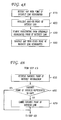
- FIGS. 4A and 4B illustrate methods for exchanging interactive map information according to an exemplary embodiment.
- an interactive map with an embedded point of interest link highlighted is received at step 410 at one or more communication devices, e.g., devices 110 B and 110 C, from a communication device, e.g., communication device 110 A.
- the map with embedded links to points of interest may be obtained by the communication device 110 A from the map server 130 , and a user of the communication device 110 A may select a point of interest link to highlight, as described above.
- one or more of the communication devices receiving the map e.g., communication device 110 B, highlights another embedded point of interest link on the map responsive to user input.
- Highlighting is removed from the originally highlighted point of interest link at step 430 by the device 110 B.
- the communication device 110 B then transmits the map with the other point of interest link highlighted to the communication device that originally transmitted the map, e.g., device 110 A, and to the other communication device that originally received the map, device 110 C.
- a communication device receiving the map may query a favorite points of interest database stored within the device and retrieve favorite points of interest in the geographical area represented by the map at step 450 . This step may be performed, e.g., after step 410 .
- the communication device 110 C may determine whether any of the favorite points of interest are represented on the map. If not, a link graphically representing the favorite point of interest may be embedded in the map at step 470 . From steps 470 and 460 , the method may return to step 420 , and the favorite point of internet link may be highlighted in the map and sent to the devices 110 A and 110 B in a manner similar to that described above.
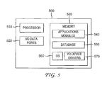
- FIG. 5 is a block diagram of a device 500 , such as the map server 130 , for providing a map of a geographical area based on a query from a device, e.g., communication devices 110 A, 110 B, and 110 C.
- the device 500 includes a processor 510 that receives information, such as location indicating information and requests for maps from communication devices 110 A, 110 B, and 110 C via I/O Data Ports 520 .
- the I/O Data Ports 520 can be implemented with, e.g., an interface including an antenna or other suitable type of transceiver through which data and signals may be transmitted and received. It should be appreciated that the I/O Data Ports 520 can be used for communications with the communication devices 110 A, 110 B, and 110 C via the communication network 120 .
- the processor 510 communicates with the memory 530 via, e.g., an address/data bus.
- the processor 510 can be any commercially available or customer microprocessor.
- the memory is 530 is representative of the overall hierarchy of memory devices containing the software and data used to implement the functionality of the device 500 .
- the memory 530 can include but is not limited to the following types of devices: processor registers, processor cache, RAM, ROM, PROM, EPROM, EEPROM, flash memory, SRAMD, DRAM other volatile memory forms, and non-volatile, semi-permanent or permanent memory types; for example, tape-based media, optical media, solid state media, hard disks, combinations thereof, and the like.
- the memory 530 may include several categories of software and data used in the device 500 , including, applications 540 , a database 550 , an operating system (OS) 560 , and the input/output (I/O) device drivers 570 .
- the OS 560 may be any operating system for use with a data processing system.
- the I/O device drivers 570 may include various routines accessed through the OS 560 by the application modules 540 to communicate with devices, and certain memory components.
- the application modules 540 can be stored in the memory 530 and/or in a firmware (not shown) as executable instructions, and can be executed by the processor 510 .
- the application modules 540 include various programs that, when executed by the processor 510 , implement the various features of the device 500 , including applications to apply to data stored in the database 550 , along with data received via the I/O ports 520 .
- the application modules 540 may generate a map of a geographical area represented by location information provided by the communication devices 110 A, 110 B, and 110 C.
- the map may include embedded interactive links graphically representing points of interest within the geographical area. Once the map is retrieved from the device 500 by one of the communication devices 110 A, 110 B, and 110 C, the map may be exchanged and altered without querying the device 500 .
- the database 550 represents the static and dynamic data used by the applications 540 , the OS 560 , the I/O device drivers 570 and other software programs that may reside in the memory 530 .
- the database 550 may include, for example, maps of various geographical areas which may be updated as appropriate.
- the memory 530 is illustrated as residing proximate the processor 510 , it should be understood that at least a portion of the memory 530 can be a remotely accessed storage system, for example, a server on a communication network, a remote hard disk drive, a removable storage medium, combinations thereof, and the like.
- any of the data, application modules, and/or software described above can be stored within the memory 530 and/or accessed via network connections to other data processing systems (not shown) that may include a local area network (LAN), a metropolitan area network (MAN), or a wide area network (WAN), for example.
- LAN local area network
- MAN metropolitan area network
- WAN wide area network
- FIG. 5 and the description above are intended to provide a brief, general description of a suitable environment in which the various aspects of some embodiments of the present disclosure can be implemented.
- this description refers to computer-readable instructions
- the present disclosure also can be implemented in combination with other program modules and/or as a combination of hardware and software in addition to, or instead of, computer readable instructions.
Abstract
Map information is exchanged between communication devices. A map of a geographical area is received. The map includes embedded interactive links that graphically represent points of interest within the geographical area. An embedded interactive link that graphically represents at least one point of interest is highlighted within the map. Responsive to selection of another embedded interactive link within the map that graphically represents another point of interest within the geographical area, the other embedded link within the map is highlighted. The map is transmitted, with the other embedded interactive link that graphically represents the other point of interest highlighted.
Description
This application is a continuation of U.S. application Ser. No. 14/205,547, filed Mar. 12, 2014, now U.S. Pat. No. 9,080,891, which is a continuation of U.S. application Ser. No. 12/958,598, filed Dec. 2, 2010, now U.S. Pat. No. 8,694,245, the entirety of which are herein incorporated by reference.
The present disclosure relates generally to telecommunications, and, more particularly, to exchanging map information between communication devices.
Cell phones and other communication devices are being deployed that provide map information. Currently, users can look up businesses or addresses using a mobile communication device and be presented with a map and/or directions. Users may share such maps and directions with each other via their communication devices.
However, maps currently exchanged in such a manner are static in the sense that they do not permit users to alter the maps and exchange the altered maps. Also, current maps are limited in the information they include.
It should be appreciated that this Summary is provided to introduce a selection of concepts in a simplified form, the concepts being further described below in the Detailed Description. This Summary is not intended to identify key features or essential features of this disclosure, nor is it intended to limit the scope of the invention.
According to one embodiment, a method is provided for exchanging map information between a first communication device and at least a second communication device. A map of a geographical area is received at the second communication device from the first communication device. The map includes embedded interactive links that graphically represent points of interest within the geographical area. An embedded interactive link that graphically represents at least one point of interest is highlighted within the map. Responsive to selection of another embedded interactive link within the map that graphically represents another point of interest within the geographical area, the other embedded link within the map is highlighted. The map is transmitted from the second communication device to the first communication device, with the other embedded interactive link that graphically represents the other point of interest highlighted.
According to another embodiment a device for exchanging map information includes an interface for receiving a map of a geographical area. The map includes embedded interactive links that graphically represent points of interest within the geographical area. An embedded interactive link that graphically represents at least one point of interest is highlighted within the map. The map further includes a processor for highlighting another embedded interactive link within the map that graphically represents another point of interest within the geographic area responsive to selection of the other embedded interactive link within the map. The map is transmitted, via the interface, with the other embedded interactive link that graphically represents the other point of interest highlighted.
According to another embodiment, a non-transitory computer program product includes a storage medium upon which instructions are recorded that, when executed by a processor, perform a method for exchanging map information. The method includes receiving a map of a geographical area. The map includes embedded interactive links that graphically represent points of interest within the geographical area. An interactive link that graphically represents at least one point of interest is highlighted within the map. The method further includes highlighting another embedded link within the map that graphically represents another point of interest within the geographic area responsive to selection of the other embedded interactive link within the map. The map is transmitted, with the other embedded interactive link that graphically represents the other point of interest highlighted.
Detailed exemplary embodiments are disclosed herein. It must be understood that the embodiments described and illustrated are merely examples that may be embodied in various and alternative forms, and combinations thereof. As used herein, the word “exemplary” is used expansively to refer to embodiments that serve as examples or illustrations. The figures are not necessarily to scale and some features may be exaggerated or minimized to show details of particular components. Specific structural and functional details disclosed herein are not to be interpreted as limiting.
According to an exemplary embodiment, one or more of the communication devices 110A, 110B, and 110C communicate location information indicating location information to a map server 130 via a network 120. The location information may indicate a current location of a communication device at a given time. Alternatively, the location information may indicate any other location selected by a communication device, e.g., a location about which a user of a communication device desires information.
The map server 130, in turn, provides a map with embedded links graphically representing points of interest within the geographical area of the location indicated by one or more of the devices requesting the map. Once a map is obtained from the map server 130, the communication devices 110A, 110B, and 110C exchange map information with each other via the network 120, interactively highlighting embedded links to points of interest within the map, removing highlight from links within the map, generating routes to various points of interest, embedding links to additional points of interests and including routes to such points within the map, etc. In this manner, the users of the communication devices 110A, 110B, and 110C may exchange interactive information for planning a trip, scheduling a meeting, etc.
The communication devices 110A, 110B, and 110C may be implemented with mobile communication devices, such as the device 110 described in detail below with reference to FIG. 2 . Alternatively, one or more of the communication devices 110A, 110B, and 110C may be implemented with a personal computing device. Although three communication devices 110A, 110B, and 110C are shown in FIG. 1 for illustrative purposes, it should be appreciated that any number of communication devices may exchange interactive map information in the manner set forth in this disclosure. Moreover, although three GPS satellites 105A, 105B, and 105C are illustrated, any number of location devices may be used.
The map server 130 may be implemented with a device such as the device 500 described in further detail below with reference to FIG. 5 . The network 120 may be implemented with one or more wireless networks that use exemplary telecommunications standards, such as Global System for Mobile communications (GSM) and Universal Mobile Telecommunications Systems (UMTS). It should be understood, however, that the embodiments may be implemented in wireless networks that use any existing or yet to be developed telecommunications technology. Some examples of other suitable telecommunication technologies include, but are not limited to, networks utilizing Time Division Multiple Access (TDMA), Frequency Division Multiple Access (FDMA), Wideband Code Division Multiple Access (WCDMA), Orthogonal Frequency Division Multiplexing (OFDM), Long Term Evolution (LTE), and various other 2G, 2.5G, 3G, 4G, and greater generation technologies. Examples of suitable data bearers include, but are not limited to General Packet Radio Service (GPRS), Enhanced Data rates for Global Evolution (EDGE), the High-Speed Packet Access (HSDPA) protocol family, such as High-Speed Downlink Packet Access (HSDPA), Enhanced Uplink (EUL) or otherwise termed High-Speed Uplink Packet Access (HSUPA), Evolved HSPA (HSPA+) and various other current and future data bearers.
It should be understood that FIG. 2 and the following description are intended to provide a brief, general description of a suitable environment in which the various aspects of some embodiments of the present disclosure can be implemented. While the description includes a general context of computer-executable instructions, the present disclosure can also be implemented in combination with other program modules and/or as a combination of hardware and software. The term “application,” or variants thereof, is used expansively herein to include routines, program modules, program components, data structures, algorithms, and the like. Applications can be implemented on various system configurations, including single-processor or multiprocessor systems, minicomputers, mainframe computers, personal computers, handheld-computing devices, microprocessor-based, programmable consumer electronics, combinations thereof, and the like.
Referring to FIG. 2 , a device 110 may be a multimode handset and can include a variety of computer-readable media, including volatile media, non-volatile media, removable media, and non-removable media. The term “computer-readable media” and variants thereof, as used in the specification and claims, can include storage media. Storage media can include volatile and/or non-volatile, removable and/or non-removable media, such as, for example, RAM, ROM, EEPROM, flash memory or other memory technology, CDROM, DVD, or other optical disk storage, magnetic tape, magnetic disk storage, or other magnetic storage devices or any other medium that can be used to store information that can be accessed by the device 110.
The device 110 may include a display 200 for displaying multimedia, such as, for example, text, images, video, telephone functions, such as Caller ID data, setup functions, menus, music metadata, messages, wallpaper, graphics, Internet content, device status, preference settings, and the like.
According to an exemplary embodiment, the display 200 may display interactive maps with embedded links graphically representing points of interest. One or more of the embedded links may be highlighted upon selection by a user. The display may also show one or more routes to one or more selected points of interest, and a selected route may be highlighted. The display 200 may be an interactive touch screen or a screen that may be manipulated with a cursor, e.g., for selecting links of interest embedded within a map. The display 200 may also display information related to the interactive map, e.g., directions to selected points of interest from a starting location within the geographical area represented by the map.
The device 110 may include a processor 202 for controlling and/or processing data. A memory 204 can interface with the processor 202 for the storage of data and/or applications 206.
The applications 206 may include, for example, SMS messaging software, EMS message software, MMS messaging software, USSD software, a WAP browser, and the like.
Also, according to an exemplary embodiment, the applications 206 may include an interactive map application 207 for use in highlighting points of interest in a map responsive to selection of points of interest in the map, generating routes to points of interest from a particular location and including the routes in the map, highlighting the generated routes, determining whether favorite points of interest are included in the map and embedding links to favorite points of interest in the map as appropriate, generating routes to the favorite points of interest and including the routes to the favorite points of interest in the map, highlighting the embedded links to the favorite points of interest and the respective routes, etc.
The applications 206 may also include a user interface (UI) application 208. The UI application 208 can interact with a client 210 (e.g., an operating system) to facilitate user interaction with device functionality and data, for example, entering message content, viewing received messages, answering/initiating calls, entering/deleting data, password entry and settings, configuring settings, address book manipulation, and the like. Such user interaction may be facilitated via, e.g., a keypad or a touchscreen included in the device 110 or communicating with the device via the I/O interface 224. Also, according to exemplary embodiments, the UI application 208 can be used for interacting with a map displayed on the display 200, e.g., to select embedded links to points of interest. For example, for a map represented in a JPEG format, a link and/or a route may be highlighted by turning a bit corresponding to a selected area within the display on, and highlighting may be removed by turning the bit off.
The applications 206 may include other applications 212, such as, for example, add-ons, plug-ins, email applications, music application, video applications, camera applications, location-based service (LSB) applications, power conservation applications, game applications, productivity applications, entertainment applications, combinations thereof, and the like, as well as subsystem and/or components.
The applications 206 can be stored in the memory and/or in firmware components 214 and can be executed by the processor 202. The firmware 214 can also store code for execution during initialization of the device 110.
A communications component 216 may interface with the processor 202 to facilitate wired/wireless communication with external systems including, for example, cellular networks, location systems, VoIP networks, local area networks (LAN's), wide area networks (WAN's), metropolitan area networks (MAN's), personal area networks (PAN's), and other networks, which may be implemented using WIFI, WIMAX, combinations and improvements thereof, and the like. The communications component 216 can also include a multimode communication subsystem for providing cellular communications via different cellular technologies. For example, a first cellular transceiver 218 can operate in one mode, for example, GSM, and an Nth transceiver 220 can operate in a different mode, for example UMTS. While only two transceivers 218, 220 are illustrated, it should be appreciated that a plurality of transceivers may be included. The communications component 216 may also include a transceiver 222 for other communication technologies, such as, for example, WIFI, WIMAX, BLUETOOTH, infrared, IRDA, NFC, RF, and the like. The communications components 216 may also facilitate reception from terrestrial radio networks, digital satellite radio networks, Internet based radio service networks, combinations thereof, and the like. The communications component 216 can process data from a network, such as, for example, the network 120, the Internet, a corporate network, a home broadband network, a WIFI hotspot, and the like via an ISP, DSL provider, or broadband provider. The communications component 216 can be used to receive maps with embedded links and transmit maps with embedded links from and to other communication devices via the network 120. Also, the communications component 216 may be used to receive a map from a map server 130 via the network, upon an initial query.
An input/output (I/O) interface 224 may be provided for input/output of data and/or signals. The I/O interface 224 may be a hardwire connection, such as, for example, a USB, mini-USB, audio jack, PS2, IEEE 1394, serial, parallel, Ethernet (RJ48), RJ11, and the like, and can accept other I/O devices such as, for example, keyboards, keypads, mice, interface tethers, stylus pens, printers, thumb drives, touch screens, multi-touch screens, touch pads, trackballs, joysticks, microphones, remote control devices, monitors, displays and liquid crystal displays (LCDs), combinations thereof, and the like. It should be appreciated that the I/O interface 224 can be used for communication between the device and a network or local device instead of, or in addition to, the communications component 216.
Audio capabilities may be provided by an audio I/O component 226 that may include a speaker for the output of audio signals and a microphone to collect audio signals. The device 110 can include a slot interface 228 for accommodating a subscriber identity system 230 such as, for example, a subscriber identity module (SIM) or universal SIM (USIM). The subscriber identity system 230 instead can be manufactured into the device 110, thereby obviating the need for a slot interface 228. In some embodiments, the subscriber identity system 230 can store certain features, user characteristics, rules, policies, models, contact information, and the like. The subscriber identity system 230 can be programmed by a manufacturer, a retailer, a user, a computer, a network operator, and the like.
According to an exemplary embodiment, the subscriber identity system 230 may include favorite points of interest associated with various geographical areas. Alternatively, the favorite points of interest may be stored in the memory 204. The favorite points of interest associated with a particular geographical area may be retrieved, e.g., by the interactive map location 207 executed by the processor 202, when a map of the particular geographical area is received. Links graphically representing the favorite points of interest may be automatically embedded within the map, or the links may be embedded upon selection and/or confirmation by a user via a suitable input, e.g., a touchscreen or a keyboard.
The device 110 can further include an image capture and processing system 232 (image system). Photos and/or videos can be obtained via an associated image capture subsystem of the image system 232, for example, a camera. The device 110 may also include a video system 234 for capturing, processing, recording, modifying, and/or transmitting video content.
A location component 236 may be included to send and/or receive signals such as, for example, GPS data, A-GPS data, WIFI/WIMAX and or cellular network triangulation data, combinations thereof, and the like. The location component 236 can interface with cellular network nodes, telephone lines, satellites, such as satellites 105A, 105B, and 105C, location transmitters and/or beacons, wireless network transmitters and receivers, for example, WIFI hotspots, radio transmitters, combinations thereof and the like. The device 110 may obtain, generate, and/or receive data to identify its location or can transmit data used by other devices to determine the device 110 location. The location of the device 110 can be provided to the map server 130 and used by the map server 130 to provide a map of the geographical area in which the device 110 is located at a given time.
The device 110 may also include a power source 238, such as batteries and/or other power subsystems (AC or DC). The power source 238 can interface with an exemplary power system or charging equipment via a power I/O component 240.
Upon receipt of a map such as that shown in FIG. 3A from a device, such as communication device 110A, another communication device, such as communication device 110B, may alter the map as shown in FIG. 3B . Referring to FIG. 3B , the map includes the embedded links 310A, 310B, 310C, and 310D graphically representing the points of interests. However, the map shown in FIG. 3B reflects a selection by the user of a device, e.g., the communication device 110B, of an embedded link 310C to an alternative point of interest. Upon selection of the link 310C, a route 330B from the selected start location 320 is generated and included in the map. The highlighting may be removed from the link 310D and the route 330A. Thus, the link 310C and the route 330B may be highlighted instead of the link 310D and the route 330A. However, the link 310D and the route 330A may remain in the map, as shown in FIG. 3B .
Instead of using the same start location 320, users of either of the communication devices 110B and 110C receiving the map from the communication device 110A may decide to use additional start locations. Thus, using the scenario depicted in FIG. 3C as an example, upon selection of the link 310E and a selection of the link 310A as a start location, another route 330D may be generated from the start location represented by the link 310A to the favorite point of interest, represented by the link 310E. The route 330D may be highlighted and included in the map, along with the highlighted route 330C as shown in FIG. 3C . As an alternative, the start location represented by the link 310E may be selected as alternate start location instead of the start location represented by the link 310A, such that only the route 330D would appear highlighted within the map. According to an exemplary embodiment, if no other start location is selected, the originally selected start location may be used as the default start location.
The map shown in FIG. 3A is an example of a map that may be transmitted from a communication device, e.g., device 110A, to one or more devices, e.g., devices 110B and 110C. This map may be transmitted to suggest a meeting place for users of the devices 110A, 110B, and 110C. The maps shown in FIGS. 3B and 3C are examples of maps altered by devices, e.g., devices 110B and 110C, respectively, that may be transmitted back to the original device, e.g., device 110A, e.g., to suggest alternate meeting places. The devices 110A, 110B, and 110C may alter information included in the maps and exchange the maps as desired, e.g., until a meeting place is agreed upon.
In addition to selecting a point of interest embedded in a received map, a communication device receiving the map, e.g., device 110C, may query a favorite points of interest database stored within the device and retrieve favorite points of interest in the geographical area represented by the map at step 450. This step may be performed, e.g., after step 410. At step 460, the communication device 110C may determine whether any of the favorite points of interest are represented on the map. If not, a link graphically representing the favorite point of interest may be embedded in the map at step 470. From steps 470 and 460, the method may return to step 420, and the favorite point of internet link may be highlighted in the map and sent to the devices 110A and 110B in a manner similar to that described above.
The processor 510 communicates with the memory 530 via, e.g., an address/data bus. The processor 510 can be any commercially available or customer microprocessor. The memory is 530 is representative of the overall hierarchy of memory devices containing the software and data used to implement the functionality of the device 500. The memory 530 can include but is not limited to the following types of devices: processor registers, processor cache, RAM, ROM, PROM, EPROM, EEPROM, flash memory, SRAMD, DRAM other volatile memory forms, and non-volatile, semi-permanent or permanent memory types; for example, tape-based media, optical media, solid state media, hard disks, combinations thereof, and the like.
As shown in FIG. 5 , the memory 530 may include several categories of software and data used in the device 500, including, applications 540, a database 550, an operating system (OS) 560, and the input/output (I/O) device drivers 570. As will be appreciated by those skilled in the art, the OS 560 may be any operating system for use with a data processing system. The I/O device drivers 570 may include various routines accessed through the OS 560 by the application modules 540 to communicate with devices, and certain memory components. The application modules 540 can be stored in the memory 530 and/or in a firmware (not shown) as executable instructions, and can be executed by the processor 510. The application modules 540 include various programs that, when executed by the processor 510, implement the various features of the device 500, including applications to apply to data stored in the database 550, along with data received via the I/O ports 520. The application modules 540 may generate a map of a geographical area represented by location information provided by the communication devices 110A, 110B, and 110C. The map may include embedded interactive links graphically representing points of interest within the geographical area. Once the map is retrieved from the device 500 by one of the communication devices 110A, 110B, and 110C, the map may be exchanged and altered without querying the device 500.
The database 550 represents the static and dynamic data used by the applications 540, the OS 560, the I/O device drivers 570 and other software programs that may reside in the memory 530. The database 550 may include, for example, maps of various geographical areas which may be updated as appropriate.
While the memory 530 is illustrated as residing proximate the processor 510, it should be understood that at least a portion of the memory 530 can be a remotely accessed storage system, for example, a server on a communication network, a remote hard disk drive, a removable storage medium, combinations thereof, and the like. Thus, any of the data, application modules, and/or software described above can be stored within the memory 530 and/or accessed via network connections to other data processing systems (not shown) that may include a local area network (LAN), a metropolitan area network (MAN), or a wide area network (WAN), for example.
It should be understood that FIG. 5 and the description above are intended to provide a brief, general description of a suitable environment in which the various aspects of some embodiments of the present disclosure can be implemented. As indicated above with reference to FIG. 2 , while this description refers to computer-readable instructions, the present disclosure also can be implemented in combination with other program modules and/or as a combination of hardware and software in addition to, or instead of, computer readable instructions.
The law does not require and it is economically prohibitive to illustrate and teach every possible embodiment of the present claims. Hence, the above-described embodiments are merely exemplary illustrations of implementations set forth for a clear understanding of the principles of the invention. Variations, modifications, and combinations may be made to the above-described embodiments without departing from the scope of the claims. All such variations, modifications, and combinations are included herein by the scope of this disclosure and the following claims.
Claims (17)
1. A method comprising:
receiving, by a first mobile communication device comprising a processor, from a second mobile communication device, map information comprising a first route connecting a first starting point selected by a user of the second mobile communication device to a first point of interest, wherein the map information indicates that the first point of interest and the first route are highlighted, wherein the first point of interest and the first route are highlighted based on a selection of the first point of interest and the first route by the user of the second mobile communication device;
displaying, by the first mobile communication device, on a display of the first mobile communication device, a map according to the map information, wherein the first point of interest and the first route appear highlighted within the map displayed by the display of the first mobile communication device;
displaying, within the map, by the first mobile communication device, a second point of interest from a plurality of points of interest stored on the first mobile communication device; and
in response to receiving a selection of the second point of interest by a user of the first mobile communication device,
generating, by the first mobile communication device, a second route connecting the first starting point selected by the user of the second mobile communication device to the second point of interest selected by the user of the first mobile communication device,
displaying, by the first mobile communication device, within the map, the second route,
highlighting, by the first mobile communication device, the second point of interest and the second route displayed within the map, and
removing, by the first mobile communication device, highlighting from the first point of interest and from the first route while the first point of interest and the first route remain displayed within the map such that a visual appearance of the first point of interest and the first route that remain displayed within the map is different from a visual appearance of the second point of interest and the second route displayed within the map.
2. The method of claim 1 , further comprising:
receiving, by the first mobile communication device, from the user of the first mobile communication device, a selection of a second starting point within the map;
generating, by the first mobile communication device, a third route connecting the second starting point and the second point of interest;
displaying, by the first mobile communication device, within the map, the third route, and
highlighting, by the first mobile communication device, the third route displayed within the map.
3. The method of claim 1 , wherein the first point of interest and the second point of interest are associated with a geographical area corresponding to the map information.
4. The method of claim 1 , further comprising transmitting, by the first mobile communication device, the map information, as altered by the first mobile communication device, back to the second mobile communication device.
5. The method of claim 1 , further comprising:
generating, by the first mobile communication device, directions from the first starting point to the second point of interest; and
displaying, by the first mobile communication device, on the display of the first mobile communication device, the directions from the first starting point to the second point of interest.
6. The method of claim 1 , wherein the plurality of points of interest are stored in a subscriber identity system of the first mobile communication device.
7. A first mobile communication device comprising:
a display;
a processor; and
computer-readable media storing instructions that, when executed by the processor, cause the processor to perform operations comprising
receiving, from a second mobile communication device, map information comprising a first route connecting a first starting point selected by a user of the second mobile communication device to a first point of interest, wherein the map information indicates that the first point of interest and the first route are highlighted, wherein the first point of interest and the first route are highlighted based on a selection of the first point of interest and the first route by the user of the second mobile communication device,
displaying, on the display, a map according to the map information, wherein the first point of interest and the first route appear highlighted within the map displayed by the display of the first mobile communication device,
displaying, within the map, a second point of interest from a plurality of points of interest stored on the first mobile communication device, and
in response to receiving a selection of the second point of interest by a user of the first mobile communication device,
generating a second route connecting the first starting point selected by the user of the second mobile communication device to the second point of interest selected by the user of the first mobile communication device,
displaying, within the map, the second route,
highlighting the second point of interest and the second route displayed within the map, and
removing highlighting from the first point of interest and from the first route while the first point of interest and the first route remain displayed within the map such that a visual appearance of the first point of interest and the first route that remain displayed within the map is different from a visual appearance of the second point of interest and the second route displayed within the map.
8. The first mobile communication device of claim 7 , wherein the operations further comprise:
receiving, from the user of the first mobile communication device, a selection of a second starting point within the map;
generating a third route connecting the second starting point and the second point of interest;
displaying, within the map, the third route, and
highlighting the third route displayed within the map.
9. The first mobile communication device of claim 7 , wherein the first point of interest and the second point of interest are associated with a geographical area corresponding to the map information.
10. The first mobile communication device of claim 7 , wherein the operations further comprise transmitting the map information, as altered by the first mobile communication device, back to the second mobile communication device.
11. The first mobile communication device of claim 7 , wherein the operations further comprise:
generating directions from the first starting point to the second point of interest; and
displaying, on the display of the first mobile communication device, the directions from the first starting point to the second point of interest.
12. The first mobile communication device of claim 7 , wherein the plurality of points of interest are stored in a subscriber identity system of the first mobile communication device.
13. A non-transitory computer-readable storage device comprising instructions that, when executed by a processor of a first mobile communication device, cause the processor to perform operations comprising:
receiving, from a second mobile communication device, map information comprising a first route connecting a first starting point selected by a user of the second mobile communication device to a first point of interest, wherein the map information indicates that the first point of interest and the first route are highlighted, wherein the first point of interest and the first route are highlighted based on a selection of the first point of interest and the first route by the user of the second mobile communication device;
displaying, on a display of the first mobile communication device, a map according to the map information, wherein the first point of interest and the first route appear highlighted within the map displayed by the display of the first mobile communication device;
displaying, within the map, a second point of interest from a plurality of points of interest stored on the first mobile communication device; and
in response to receiving a selection of the second point of interest by a user of the first mobile communication device,
generating a second route connecting the first starting point selected by the user of the second mobile communication device to the second point of interest selected by the user of the first mobile communication device,
displaying, within the map, the second route,
highlighting the second point of interest and the second route displayed within the map, and
removing highlighting from the first point of interest and from the first route while the first point of interest and the first route remain displayed within the map such that a visual appearance of the first point of interest and the first route that remain displayed within the map is different from a visual appearance of the second point of interest and the second route displayed within the map.
14. The non-transitory computer-readable storage device of claim 13 , wherein the operations further comprise:
receiving, from the user of the first mobile communication device, a selection of a second starting point within the map;
generating a third route connecting the second starting point and the second point of interest;
displaying, within the map, the third route, and
highlighting the third route displayed within the map.
15. The non-transitory computer-readable storage device of claim 13 , wherein the first point of interest and the second point of interest are associated with a geographical area corresponding to the map information.
16. The non-transitory computer-readable storage device of claim 13 , wherein the operations further comprise transmitting the map information, as altered by the first mobile communication device, back to the second mobile communication device.
17. The non-transitory computer-readable storage device of claim 13 , wherein the operations further comprise:
generating directions from the first starting point to the second point of interest; and
displaying, on the display of the first mobile communication device, the directions from the first starting point to the second point of interest.
Priority Applications (1)
| Application Number | Priority Date | Filing Date | Title |
|---|---|---|---|
| US14/790,922 US9778062B2 (en) | 2010-12-02 | 2015-07-02 | Methods, devices, and computer program products for exchanging interactive map information |
Applications Claiming Priority (3)
| Application Number | Priority Date | Filing Date | Title |
|---|---|---|---|
| US12/958,598 US8694245B2 (en) | 2010-12-02 | 2010-12-02 | Methods, devices, and computer program products for exchanging interactive map information |
| US14/205,547 US9080891B2 (en) | 2010-12-02 | 2014-03-12 | Methods, devices, and computer program products for exchanging interactive map information |
| US14/790,922 US9778062B2 (en) | 2010-12-02 | 2015-07-02 | Methods, devices, and computer program products for exchanging interactive map information |
Related Parent Applications (1)
| Application Number | Title | Priority Date | Filing Date |
|---|---|---|---|
| US14/205,547 Continuation US9080891B2 (en) | 2010-12-02 | 2014-03-12 | Methods, devices, and computer program products for exchanging interactive map information |
Publications (2)
| Publication Number | Publication Date |
|---|---|
| US20150308853A1 US20150308853A1 (en) | 2015-10-29 |
| US9778062B2 true US9778062B2 (en) | 2017-10-03 |
Family
ID=46163012
Family Applications (3)
| Application Number | Title | Priority Date | Filing Date |
|---|---|---|---|
| US12/958,598 Active 2032-09-15 US8694245B2 (en) | 2010-12-02 | 2010-12-02 | Methods, devices, and computer program products for exchanging interactive map information |
| US14/205,547 Active US9080891B2 (en) | 2010-12-02 | 2014-03-12 | Methods, devices, and computer program products for exchanging interactive map information |
| US14/790,922 Active US9778062B2 (en) | 2010-12-02 | 2015-07-02 | Methods, devices, and computer program products for exchanging interactive map information |
Family Applications Before (2)
| Application Number | Title | Priority Date | Filing Date |
|---|---|---|---|
| US12/958,598 Active 2032-09-15 US8694245B2 (en) | 2010-12-02 | 2010-12-02 | Methods, devices, and computer program products for exchanging interactive map information |
| US14/205,547 Active US9080891B2 (en) | 2010-12-02 | 2014-03-12 | Methods, devices, and computer program products for exchanging interactive map information |
Country Status (1)
| Country | Link |
|---|---|
| US (3) | US8694245B2 (en) |
Cited By (1)
| Publication number | Priority date | Publication date | Assignee | Title |
|---|---|---|---|---|
| US11265676B2 (en) * | 2012-02-29 | 2022-03-01 | Google Llc | System and method for requesting an updated user location |
Families Citing this family (19)
| Publication number | Priority date | Publication date | Assignee | Title |
|---|---|---|---|---|
| US8818986B1 (en) * | 2011-07-27 | 2014-08-26 | Sprint Communications Company L.P. | Onboard advance search refinement |
| US20130061147A1 (en) * | 2011-09-07 | 2013-03-07 | Nokia Corporation | Method and apparatus for determining directions and navigating to geo-referenced places within images and videos |
| US20130138537A1 (en) * | 2011-11-30 | 2013-05-30 | Verizon Patent And Licensing, Inc. | System for and method of managing fiber reel data at a centralized location |
| US20130245930A1 (en) * | 2012-03-13 | 2013-09-19 | Telenav, Inc. | Navigation system with point of interest relationship mechanism and method of operation thereof |
| US9222787B2 (en) | 2012-06-05 | 2015-12-29 | Apple Inc. | System and method for acquiring map portions based on expected signal strength of route segments |
| US9538319B1 (en) * | 2012-06-20 | 2017-01-03 | Amazon Technologies, Inc. | Synchronization for mapping applications |
| US9857177B1 (en) | 2012-06-20 | 2018-01-02 | Amazon Technologies, Inc. | Personalized points of interest for mapping applications |
| US9043135B2 (en) | 2012-08-31 | 2015-05-26 | Apple Inc. | Navigation system acquisition and use of cellular coverage map data |
| US20140075348A1 (en) * | 2012-09-11 | 2014-03-13 | Nokia Corporation | Method and apparatus for associating event types with place types |
| US9596670B2 (en) | 2013-01-16 | 2017-03-14 | Apple Inc. | Location assisted service capability monitoring |
| US9432961B2 (en) | 2013-01-16 | 2016-08-30 | Apple Inc. | Location-assisted service capability monitoring |
| US9606241B2 (en) | 2013-02-21 | 2017-03-28 | Apple Inc. | Sensor-assisted location fix |
| US8812995B1 (en) * | 2013-04-10 | 2014-08-19 | Google Inc. | System and method for disambiguating item selection |
| US20170115749A1 (en) * | 2014-10-26 | 2017-04-27 | Chian Chiu Li | Systems And Methods For Presenting Map And Other Information Based On Pointing Direction |
| US10948906B2 (en) * | 2015-06-04 | 2021-03-16 | Honeywell International Inc. | Maintenance plan forecast using automation control devices' usage pattern through big data analytics |
| US9794202B1 (en) | 2016-08-25 | 2017-10-17 | Amojee, Inc. | Messaging including standard and custom characters |
| US9699299B1 (en) * | 2016-09-15 | 2017-07-04 | Amojee, Inc. | Messaging including custom characters with embedded content |
| US10298522B2 (en) | 2017-04-10 | 2019-05-21 | Amojee, Inc. | Messaging including custom characters with tags localized to language of user receiving message |
| CN109582308B (en) * | 2018-11-05 | 2021-12-28 | 中国资源卫星应用中心 | Interactive map component dynamic embedding method and system based on XEmbed |
Citations (8)
| Publication number | Priority date | Publication date | Assignee | Title |
|---|---|---|---|---|
| US20020120395A1 (en) | 2001-02-23 | 2002-08-29 | Bruce Smith | On-line navigational system |
| US20040054428A1 (en) | 2002-03-01 | 2004-03-18 | Sheha Michael A. | Method and apparatus for sending, retrieving and planning location relevant information |
| US20070032945A1 (en) | 2005-08-02 | 2007-02-08 | Jason Kaufman | System and method for providing location related information to a network user |
| US20080162037A1 (en) | 2006-12-27 | 2008-07-03 | Hasan Mahmoud Ashraf S | Location-based interactive display and communication system |
| US20090254840A1 (en) | 2008-04-04 | 2009-10-08 | Yahoo! Inc. | Local map chat |
| US20110282826A1 (en) | 2010-05-13 | 2011-11-17 | Motorola, Inc. | Destination Planner in Communication Device |
| US20110283218A1 (en) | 2010-05-13 | 2011-11-17 | Motorola, Inc. | Electronic Event Planner in Communication Device |
| US8160532B2 (en) | 2007-01-08 | 2012-04-17 | Skyweaver, Inc. | Community interaction using mobile communication devices |
-
2010
- 2010-12-02 US US12/958,598 patent/US8694245B2/en active Active
-
2014
- 2014-03-12 US US14/205,547 patent/US9080891B2/en active Active
-
2015
- 2015-07-02 US US14/790,922 patent/US9778062B2/en active Active
Patent Citations (9)
| Publication number | Priority date | Publication date | Assignee | Title |
|---|---|---|---|---|
| US20020120395A1 (en) | 2001-02-23 | 2002-08-29 | Bruce Smith | On-line navigational system |
| US20040054428A1 (en) | 2002-03-01 | 2004-03-18 | Sheha Michael A. | Method and apparatus for sending, retrieving and planning location relevant information |
| US20080036778A1 (en) * | 2002-03-01 | 2008-02-14 | Networks In Motion, Inc. | Method and apparatus for sending, retrieving and planning location relevant information |
| US20070032945A1 (en) | 2005-08-02 | 2007-02-08 | Jason Kaufman | System and method for providing location related information to a network user |
| US20080162037A1 (en) | 2006-12-27 | 2008-07-03 | Hasan Mahmoud Ashraf S | Location-based interactive display and communication system |
| US8160532B2 (en) | 2007-01-08 | 2012-04-17 | Skyweaver, Inc. | Community interaction using mobile communication devices |
| US20090254840A1 (en) | 2008-04-04 | 2009-10-08 | Yahoo! Inc. | Local map chat |
| US20110282826A1 (en) | 2010-05-13 | 2011-11-17 | Motorola, Inc. | Destination Planner in Communication Device |
| US20110283218A1 (en) | 2010-05-13 | 2011-11-17 | Motorola, Inc. | Electronic Event Planner in Communication Device |
Non-Patent Citations (5)
| Title |
|---|
| Notice of Allowance mailed Jan. 23, 2014 in U.S. Appl. No. 12/958,598. |
| Notice of Allowance mailed Mar. 12, 2015 in U.S. Appl. No. 14/205,547. |
| Notice of Allowance mailed Nov. 15, 2013 in U.S. Appl. No. 12/958,598. |
| Office Action mailed Jul. 16, 2013 in U.S. Appl. No. 12/958,598. |
| Office Action mailed Oct. 2, 2014 in U.S. Appl. No. 14/205,547. |
Cited By (2)
| Publication number | Priority date | Publication date | Assignee | Title |
|---|---|---|---|---|
| US11265676B2 (en) * | 2012-02-29 | 2022-03-01 | Google Llc | System and method for requesting an updated user location |
| US11825378B2 (en) | 2012-02-29 | 2023-11-21 | Google Llc | System and method for requesting an updated user location |
Also Published As
| Publication number | Publication date |
|---|---|
| US20140337701A1 (en) | 2014-11-13 |
| US20120143498A1 (en) | 2012-06-07 |
| US20150308853A1 (en) | 2015-10-29 |
| US9080891B2 (en) | 2015-07-14 |
| US8694245B2 (en) | 2014-04-08 |
Similar Documents
| Publication | Publication Date | Title |
|---|---|---|
| US9778062B2 (en) | Methods, devices, and computer program products for exchanging interactive map information | |
| US10104229B2 (en) | Routing service | |
| US9847957B2 (en) | Method, system, and computer readable storage device for managing message delivery based on context of recipients and message content | |
| US8811912B2 (en) | Remote control of mobile devices to perform testing of wireless communications networks | |
| US8069143B2 (en) | Systems and methods for remote deletion of contact information | |
| US8682300B2 (en) | Adaptation of notification perimeter based on relevance to a user | |
| US9143512B2 (en) | Communication devices, computer readable storage devices, and methods for secure multi-path communication | |
| CN102480566B (en) | Share the apparatus and method of capture-data in portable terminal | |
| US20110082746A1 (en) | Systems and Methods for Providing Location Based Promotions and Feedback Services | |
| JP6640855B2 (en) | Method, server, and terminal device for deleting push information | |
| US8526586B2 (en) | Methods, systems, and computer program products for determining targeted content to provide in response to a missed communication | |
| TWI474027B (en) | Method, apparatus, and computer program product for location sharing | |
| US10743281B2 (en) | Methods, devices, and computer readable storage devices for collecting and reporting location data with a high accuracy | |
| CN104219356A (en) | Method and device for displaying and searching contact man information and mobile terminal | |
| KR20120107152A (en) | Remote operation system and remote operation method for terminal | |
| US10171394B2 (en) | Multimedia mail service | |
| CN105721272B (en) | Message sending, receiving and displaying method and system, sending end and receiving end | |
| KR101531309B1 (en) | Method for providing service by application after a call | |
| KR101780321B1 (en) | Message management system and method using an user terminal | |
| US9461948B2 (en) | System having a gateway for providing email based on interest in subscriber profile | |
| KR101723242B1 (en) | Device for managing message of mobile terminal and method thereof | |
| JP5901928B2 (en) | User terminal and data storage method | |
| US9282071B1 (en) | Location based message discovery | |
| JP2020009030A (en) | Information processing system, information processing system control method, and information processing system control program |
Legal Events
| Date | Code | Title | Description |
|---|---|---|---|
| AS | Assignment |
Owner name: AT&T MOBILITY II LLC, GEORGIA Free format text: ASSIGNMENT OF ASSIGNORS INTEREST;ASSIGNORS:ZUBAS, MICHAEL;CAUSEY, MARK;LUU, ADRIANNE;REEL/FRAME:036198/0293 Effective date: 20101130 |
|
| STCF | Information on status: patent grant |
Free format text: PATENTED CASE |
|
| MAFP | Maintenance fee payment |
Free format text: PAYMENT OF MAINTENANCE FEE, 4TH YEAR, LARGE ENTITY (ORIGINAL EVENT CODE: M1551); ENTITY STATUS OF PATENT OWNER: LARGE ENTITY Year of fee payment: 4 |