US9151624B2 - Data services via receivers independent of navigation systems - Google Patents
Data services via receivers independent of navigation systems Download PDFInfo
- Publication number
- US9151624B2 US9151624B2 US12/772,603 US77260310A US9151624B2 US 9151624 B2 US9151624 B2 US 9151624B2 US 77260310 A US77260310 A US 77260310A US 9151624 B2 US9151624 B2 US 9151624B2
- Authority
- US
- United States
- Prior art keywords
- data
- current location
- receiver
- sdars
- weather
- Prior art date
- Legal status (The legal status is an assumption and is not a legal conclusion. Google has not performed a legal analysis and makes no representation as to the accuracy of the status listed.)
- Active
Links
Images


Classifications
-
- H—ELECTRICITY
- H04—ELECTRIC COMMUNICATION TECHNIQUE
- H04W—WIRELESS COMMUNICATION NETWORKS
- H04W4/00—Services specially adapted for wireless communication networks; Facilities therefor
- H04W4/02—Services making use of location information
-
- H—ELECTRICITY
- H04—ELECTRIC COMMUNICATION TECHNIQUE
- H04W—WIRELESS COMMUNICATION NETWORKS
- H04W4/00—Services specially adapted for wireless communication networks; Facilities therefor
- H04W4/02—Services making use of location information
- H04W4/029—Location-based management or tracking services
-
- G—PHYSICS
- G01—MEASURING; TESTING
- G01C—MEASURING DISTANCES, LEVELS OR BEARINGS; SURVEYING; NAVIGATION; GYROSCOPIC INSTRUMENTS; PHOTOGRAMMETRY OR VIDEOGRAMMETRY
- G01C21/00—Navigation; Navigational instruments not provided for in groups G01C1/00 - G01C19/00
- G01C21/26—Navigation; Navigational instruments not provided for in groups G01C1/00 - G01C19/00 specially adapted for navigation in a road network
-
- G—PHYSICS
- G01—MEASURING; TESTING
- G01S—RADIO DIRECTION-FINDING; RADIO NAVIGATION; DETERMINING DISTANCE OR VELOCITY BY USE OF RADIO WAVES; LOCATING OR PRESENCE-DETECTING BY USE OF THE REFLECTION OR RERADIATION OF RADIO WAVES; ANALOGOUS ARRANGEMENTS USING OTHER WAVES
- G01S19/00—Satellite radio beacon positioning systems; Determining position, velocity or attitude using signals transmitted by such systems
- G01S19/38—Determining a navigation solution using signals transmitted by a satellite radio beacon positioning system
- G01S19/39—Determining a navigation solution using signals transmitted by a satellite radio beacon positioning system the satellite radio beacon positioning system transmitting time-stamped messages, e.g. GPS [Global Positioning System], GLONASS [Global Orbiting Navigation Satellite System] or GALILEO
- G01S19/42—Determining position
Definitions
- the invention relates generally to systems and methods of providing data services in a mobile environment, and in particular without requiring in-vehicle or personal navigation systems to interoperate with.
- Satellite digital radio broadcasters such as, for example, Sirius XM Radio Inc. (“Sirius XM”), currently offer well over a hundred channels of content over a large geographic footprint.
- a portion of that content can include data services that interoperate with existing GPS-based navigation services commonly available for use in automobiles, for example.
- data services can include, for example, traffic data, weather data, etc.
- Sirius XM has operated real-time traffic data services for premium navigation systems since 2004. These services provide a subscriber with real-time traffic information, enabling a vehicle's navigation system or Personal Navigation Device (“PND”) to display constantly refreshed and current traffic conditions.
- PND Personal Navigation Device
- the broadcast services provided by Sirius XM Radio Inc. each include a satellite X-band uplink to two or more satellites which provide frequency translation to the S-band for re-transmission to radio receivers on earth within a coverage area.
- Radio frequency carriers from one of the satellites are also received by terrestrial repeaters. The content received at the repeaters is retransmitted at a different S-band carrier to the same radios that are within their respective coverage areas.
- the signals transmitted by the satellites and the repeaters are received by satellite digital audio radio system (“SDARS”) receivers which can be located in automobiles, in handheld units, or in stationary units for home or office use.
- SDARS receivers are designed to receive one or both of the satellite signals and the signals from the terrestrial repeaters and dynamically combine or select one of the signals to output to a user.
- Each SDARS receiver generally contains a unique Hardware Identification number (HWID), which is assigned during the manufacturing process.
- HWID Hardware Identification number
- the HWID can be used by SDARS Service Providers to enable the receiver to receive, or disable the receiver from receiving, particular subscribed services such as music and talk programming.
- subscribed services can include data services, such as, for example, weather and traffic data feeds or other custom data feeds.
- data services such as, for example, weather and traffic data feeds or other custom data feeds.
- custom data feeds are typically uniquely enabled by the SDARS Service Provider for select subscriber groups.
- a non-navigation data system for providing data services in a mobile environment can include a data decoder for decoding a digital data stream from a digital audio radio transmission source, a location determining means for determining a current location of a mobile receiver receiving the digital data stream, a display for displaying data corresponding to the current location, and a plurality of static maps wherein the data corresponding to the current location is overlaid at least over a portion of the static maps.
- a method of providing a data service in a mobile environment without the need for a navigation system can include decoding a digital data stream from a digital audio radio transmission source, determining a current location of a mobile receiver receiving the digital data stream, displaying data corresponding to the current location, and overlaying the data corresponding to the current location over at least a portion of a plurality of static maps.
- FIG. 1 is a screen shot of tabular weather according to an exemplary embodiment of the present invention
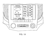
- FIG. 1A is a screen shot of an alternative weather data table, showing both current conditions and 5-day forecast according to an exemplary embodiment of the present invention
- FIG. 2 is screen shot of graphical weather according to an exemplary embodiment of the present invention
- FIG. 2A depicts an alternate tiling scheme of the continental United States according to an alternate exemplary embodiment of the present invention
- FIG. 3 is a screen shot of fuel prices according to an exemplary embodiment of the present invention.
- FIG. 3A is a screen shot of an alternative fuel process information screen, showing both oil company logo and relative locations of gas stations superimposed on a map according to an alternate exemplary embodiment of the present invention
- FIG. 4 is a screen shot of movie listings according to an exemplary embodiment of the present invention.
- FIG. 4A is a screen shot of an alternative movie listings information screen according to an alternate exemplary embodiment of the present invention.
- FIG. 5 is a screen shot of sports scores according to an exemplary embodiment of the present invention.
- FIG. 5A is a screen shot of an alternative sports scores information screen according to an alternate exemplary embodiment of the present invention.
- patent or application file may contain at least one drawing executed in color. If that is the case, copies of this patent or patent application publication with color drawing(s) will be provided by the U.S. Patent and Trademark Office upon request and payment of the necessary fee.
- Satellite radio operators are providing digital radio broadcast services covering the entire continental United States with the hope of further covering other areas of the Americas. These services offer approximately 100 channels or more, of which nearly 50 channels in a typical configuration provides music with the remaining stations offering news, sports, talk and data channels.
- Sirius XM Radio includes a satellite X-band uplink to two satellites which provide frequency translation to the S-band for re-transmission to radio receivers on earth within a coverage area. Radio frequency carriers from one of the satellites are also received by terrestrial repeaters. The content received at the repeaters is retransmitted at a different S-band carrier to the same radios that are within their respective coverage areas.
- Satellite digital audio radio system SDARS
- the SDARS receivers are designed to receive one or both of the satellite signals and the signals from the terrestrial repeaters and combine or select one of the signals as the receiver output.
- Each SDARS receiver contains a unique Hardware Identification number (HWID), which is assigned during the manufacturing process and is used by SDARS Service Providers to enable or disable the radio to receive subscribed services, such as music and talk programming.
- these subscribed services could include data services, such as weather and traffic data feeds or other custom data feeds.
- the custom data feeds are typically uniquely enabled by the SDARS Service Provider for select subscriber groups.
- existing telematics systems using cellular and Global Positioning System (GPS) technology such as the On-Star system currently track vehicles and provide services such as dispatching emergency road side assistance upon detection of certain detected events at the vehicle, no existing system graphically provides enhanced data services without providing a navigation system that typically requires additional memory and resources to operate.
- GPS Global Positioning System
- data services are offered that expand the range of target head units from navigation based systems to non-navigation based systems.
- the following hardware and system configuration can be assumed: (i) GPS present or a cellular location determining mechanism using time distance of arrival for example or other technique; (ii) nNo on board maps or routing database; (iii) an Alert-C decoder in the head unit to decode the Sirius XM non-navigation traffic messages.
- the data services can include, for example, the following:
- the tabular weather service can be based on an existing data feed, and can, for example, mirror current weather markets;
- Movie times provide schedule data for x theaters y miles from vehicle.
- Sports scores can be identical, for example, to the Sirius Travel Link® service, described at, for example, the following URL: http.fordvehicles.com/assets/modules/sirius/brochures/Travel_Link_Brochure_ford.pdf, which is hereby incorporated herein by reference.
- GPS can be used to present relevant weather data to users, based on the weather market associated with the user's then current location. Additionally, a customer can select an alternate weather market from drop down menu, speech recognition, or other user friendly input method. In exemplary embodiments of the present invention no modification required to the weather data feeds currently used by SDARS providers in connection with in-vehicle navigation systems. Thus, in exemplary embodiments of the present invention, a non-nav tabular weather service can be essentially identical to a navigation system based service
- FIGS. 1 and 1A depict exemplary screen shots of tabular weather on a non-nav system according to an exemplary embodiment of the present invention.
- FIG. 1 for example, displays a 5 day forecast for the Detroit area
- FIG. 1A has a combined current weather conditions and 5 day forecast display.
- FIG. 2 depicts an exemplary screen shot of a graphical weather display according to an exemplary embodiment of the present invention.
- a graphical weather service can be based on existing data feeds used by SDARS providers in connection with navigation-based data services.
- a country can be divided into a 16 tile map, matching the WSI tiles, and weather data can be, for example, overlaid onto the map.
- a country or area can be divided into a different number of tiles, such as, for example, twelve.
- up to four tiles of such weather data can be used to display one tile of pertinent weather information.
- FIG. 3 depicts an exemplary screen shot of fuel prices data according to an exemplary embodiment of the present invention.
- distance and direction to each station is displayed.
- FIG. 3A depicts an alternate exemplary embodiment, where the oil company logo is displayed at the far left, and the relative location of each listed gas station can be displayed overlaid on a map.
- a fuel price data service can be implemented, for example, with minor or no modification required to existing fuel price data feeds used in connection with navigation systems.
- FIG. 4 depicts an exemplary screen shot of local movie listings according to an exemplary embodiment of the present invention
- FIG. 4A depicts a screen shot of an alternate exemplary embodiment of this data service.
- both distance and direction to theater can be displayed in the same manner shown for fueling stations in FIGS. 3 and 3A .
- a non-nav based movie information service can be based on existing data feeds used in connection with navigation-based systems.
- such a fuel price data service can be based on, and can be implemented, for example, with minor or no modification required to existing movie information data feeds used in connection with navigation-based systems.
- such exemplary non-nav based movie information services can be, for example, essentially identical to similar navigation system based movie information services.
- FIG. 5 depicts an exemplary screen shot of a sports scores data service according to exemplary embodiments of the present invention.
- FIG. 5A depicts an alternate exemplary screen shot of this service according to alternate exemplary embodiments of the present invention.
- a non-nav based sports score information service can be based on existing data feeds used in connection with navigation-based systems. Additionally, in exemplary embodiments of the present invention, a non-nav based sports score service can be based on, and provided with no or minor modification to existing sports information data feeds used by SDARS providers in connection with navigation-based systems.
- HMI sports data human machine interfaces
- non-nav based sports score service can be, for example, essentially identical to similar navigation-based sports score services, such as, as noted above, the Sirius Travel Link® service.
- messaging formats are not limited to TMC, but can include other formats such as, for example, TPEG or other proprietary or nonproprietary formats.
- Decoders used in exemplary embodiments of the present invention are not limited to Alert-C decoders, but can, for example, be implemented using any other standard or proprietary decoder format.
- the described exemplary embodiments primarily entail head unit applications in automobiles, such embodiments can also include any electronic device having a screen display. Data can be overlaid on roads on a standard map or a representative road system or on custom maps such as, for example, a given city's subway map.
- certain TMC location codes can be removed or certain TMC location codes can be added to smooth the colored flow information.
- GPS can be used to automatically display the appropriate map, market, or correct/relevant data.
- Embodiments herein can be also be implemented as a screen-less non-navigation system (with or without GPS).
Abstract
Description
Claims (19)
Priority Applications (2)
| Application Number | Priority Date | Filing Date | Title |
|---|---|---|---|
| US12/772,603 US9151624B2 (en) | 2009-05-01 | 2010-05-03 | Data services via receivers independent of navigation systems |
| US14/861,202 US20160112832A1 (en) | 2009-05-01 | 2015-09-22 | Data services via receivers independent of navigation systems |
Applications Claiming Priority (2)
| Application Number | Priority Date | Filing Date | Title |
|---|---|---|---|
| US17495409P | 2009-05-01 | 2009-05-01 | |
| US12/772,603 US9151624B2 (en) | 2009-05-01 | 2010-05-03 | Data services via receivers independent of navigation systems |
Related Child Applications (1)
| Application Number | Title | Priority Date | Filing Date |
|---|---|---|---|
| US14/861,202 Continuation US20160112832A1 (en) | 2009-05-01 | 2015-09-22 | Data services via receivers independent of navigation systems |
Publications (2)
| Publication Number | Publication Date |
|---|---|
| US20100317365A1 US20100317365A1 (en) | 2010-12-16 |
| US9151624B2 true US9151624B2 (en) | 2015-10-06 |
Family
ID=43032598
Family Applications (2)
| Application Number | Title | Priority Date | Filing Date |
|---|---|---|---|
| US12/772,603 Active US9151624B2 (en) | 2009-05-01 | 2010-05-03 | Data services via receivers independent of navigation systems |
| US14/861,202 Abandoned US20160112832A1 (en) | 2009-05-01 | 2015-09-22 | Data services via receivers independent of navigation systems |
Family Applications After (1)
| Application Number | Title | Priority Date | Filing Date |
|---|---|---|---|
| US14/861,202 Abandoned US20160112832A1 (en) | 2009-05-01 | 2015-09-22 | Data services via receivers independent of navigation systems |
Country Status (4)
| Country | Link |
|---|---|
| US (2) | US9151624B2 (en) |
| CA (1) | CA2760190A1 (en) |
| MX (1) | MX2011011608A (en) |
| WO (1) | WO2010127350A1 (en) |
Families Citing this family (4)
| Publication number | Priority date | Publication date | Assignee | Title |
|---|---|---|---|---|
| US20130346593A1 (en) * | 2012-06-22 | 2013-12-26 | Nokia Corporation | Method and apparatus for providing transition to an alternate service based on performance degradation of an initial service |
| CA2889175C (en) * | 2012-10-26 | 2021-02-23 | Sirius Xm Radio Inc. | Systems and methods for cost effective distribution of files to user devices using combination of broadcast and two-way communication paths |
| EP2887018B1 (en) | 2013-12-18 | 2018-02-07 | Harman Becker Automotive Systems GmbH | Method and system for providing fueling cost information in a vehicle |
| US9739619B2 (en) | 2014-04-23 | 2017-08-22 | Here Global B.V. | Dynamic traffic rendering |
Citations (24)
| Publication number | Priority date | Publication date | Assignee | Title |
|---|---|---|---|---|
| US6339745B1 (en) * | 1998-10-13 | 2002-01-15 | Integrated Systems Research Corporation | System and method for fleet tracking |
| US20020171581A1 (en) * | 1998-04-28 | 2002-11-21 | Leonid Sheynblat | Method and apparatus for providing location-based information via a computer network |
| US20040049389A1 (en) * | 2002-09-10 | 2004-03-11 | Paul Marko | Method and apparatus for streaming text to speech in a radio communication system |
| US6785551B1 (en) * | 2000-04-07 | 2004-08-31 | Ford Motor Company | Method of providing dynamic regionally relevant data to a mobile environment |
| US20040172372A1 (en) * | 2003-02-27 | 2004-09-02 | Wells Paul Christopher | Automated price management system |
| US20050020238A1 (en) * | 2003-07-24 | 2005-01-27 | Eastman Neil S. | Computer based multi-channel radio system and user interface |
| US6947703B2 (en) * | 2002-05-20 | 2005-09-20 | Ceresoli Carl D | System for determining satellite radio listener statistics |
| US20050221843A1 (en) * | 2004-03-30 | 2005-10-06 | Kimberley Friedman | Distribution of location specific advertising information via wireless communication network |
| US20060148400A1 (en) * | 2005-01-04 | 2006-07-06 | Farrow Daniel W | Device and method to store product information |
| US7142608B2 (en) | 2000-07-04 | 2006-11-28 | Robert Bosch Gmbh | Method for the transmission of digital data by means of radio signals with orthogonal frequency division multiplexing (OFDM) |
| US20060277565A1 (en) * | 2005-06-06 | 2006-12-07 | Long Jerral A | Dynamic content rating in a digital broadcast |
| US20060281401A1 (en) * | 2005-06-13 | 2006-12-14 | Dibiaso Eric A | Method and system to acquire customizable data in a satellite radio system |
| US20070136086A1 (en) * | 2005-10-17 | 2007-06-14 | Luerssen Brian T | System and method for providing location-based information to a mobile device |
| US20070265744A1 (en) * | 2006-05-12 | 2007-11-15 | Electronic Data Systems Corporation | Vehicle information system and method |
| US20080009239A1 (en) * | 2003-09-16 | 2008-01-10 | At&T Bls Intellectual Property, Inc. | Digital Radio Feedback Apparatuses, System, and Methods |
| US20080032721A1 (en) * | 2006-08-04 | 2008-02-07 | Gm Global Technology Operations, Inc. | Method and system for communicating information to a user of a mobile platform via broadcast services |
| US20080167812A1 (en) * | 2007-01-10 | 2008-07-10 | Pieter Geelen | Navigation device and method for fuel pricing display |
| US20090265099A1 (en) * | 2008-04-22 | 2009-10-22 | Mark Gottlieb | Context-sensitive navigational aid |
| US20090316671A1 (en) * | 2008-05-16 | 2009-12-24 | La Crosse Technology, Ltd. | Method and Apparatus of Transmitting, Receiving, Displaying and Playing Weather Data |
| US20100049528A1 (en) * | 2007-01-05 | 2010-02-25 | Johnson Controls Technology Company | System and method for customized prompting |
| US20100097239A1 (en) * | 2007-01-23 | 2010-04-22 | Campbell Douglas C | Mobile device gateway systems and methods |
| US20100161090A1 (en) * | 2008-12-23 | 2010-06-24 | Tau Cygnus, Llc | Data management system for portable media devices and other display devices |
| US20100250369A1 (en) * | 2009-03-27 | 2010-09-30 | Michael Peterson | Method and system for automatically selecting and displaying traffic images |
| US20100280956A1 (en) * | 2007-12-26 | 2010-11-04 | Johnson Controls Technology Company | Systems and methods for conducting commerce in a vehicle |
Family Cites Families (3)
| Publication number | Priority date | Publication date | Assignee | Title |
|---|---|---|---|---|
| GB0304728D0 (en) * | 2003-03-01 | 2003-04-02 | Lo Anthony T S | Simplified and improved holmes-style stereographic (3D) viewer |
| US7565239B2 (en) * | 2005-05-06 | 2009-07-21 | Alpine Electronics, Inc. | Method and apparatus for navigation system for searching selected type of information along route to destination |
| JP4878160B2 (en) * | 2006-01-04 | 2012-02-15 | クラリオン株式会社 | Traffic information display method and navigation system |
-
2010
- 2010-05-03 US US12/772,603 patent/US9151624B2/en active Active
- 2010-05-03 MX MX2011011608A patent/MX2011011608A/en active IP Right Grant
- 2010-05-03 CA CA2760190A patent/CA2760190A1/en not_active Abandoned
- 2010-05-03 WO PCT/US2010/033403 patent/WO2010127350A1/en active Application Filing
-
2015
- 2015-09-22 US US14/861,202 patent/US20160112832A1/en not_active Abandoned
Patent Citations (25)
| Publication number | Priority date | Publication date | Assignee | Title |
|---|---|---|---|---|
| US20020171581A1 (en) * | 1998-04-28 | 2002-11-21 | Leonid Sheynblat | Method and apparatus for providing location-based information via a computer network |
| US6339745B1 (en) * | 1998-10-13 | 2002-01-15 | Integrated Systems Research Corporation | System and method for fleet tracking |
| US6785551B1 (en) * | 2000-04-07 | 2004-08-31 | Ford Motor Company | Method of providing dynamic regionally relevant data to a mobile environment |
| US7142608B2 (en) | 2000-07-04 | 2006-11-28 | Robert Bosch Gmbh | Method for the transmission of digital data by means of radio signals with orthogonal frequency division multiplexing (OFDM) |
| US6947703B2 (en) * | 2002-05-20 | 2005-09-20 | Ceresoli Carl D | System for determining satellite radio listener statistics |
| US20040049389A1 (en) * | 2002-09-10 | 2004-03-11 | Paul Marko | Method and apparatus for streaming text to speech in a radio communication system |
| US20040172372A1 (en) * | 2003-02-27 | 2004-09-02 | Wells Paul Christopher | Automated price management system |
| US20050020238A1 (en) * | 2003-07-24 | 2005-01-27 | Eastman Neil S. | Computer based multi-channel radio system and user interface |
| US20080009239A1 (en) * | 2003-09-16 | 2008-01-10 | At&T Bls Intellectual Property, Inc. | Digital Radio Feedback Apparatuses, System, and Methods |
| US20050221843A1 (en) * | 2004-03-30 | 2005-10-06 | Kimberley Friedman | Distribution of location specific advertising information via wireless communication network |
| US20060148400A1 (en) * | 2005-01-04 | 2006-07-06 | Farrow Daniel W | Device and method to store product information |
| US20060277565A1 (en) * | 2005-06-06 | 2006-12-07 | Long Jerral A | Dynamic content rating in a digital broadcast |
| US20060281401A1 (en) * | 2005-06-13 | 2006-12-14 | Dibiaso Eric A | Method and system to acquire customizable data in a satellite radio system |
| US20070136086A1 (en) * | 2005-10-17 | 2007-06-14 | Luerssen Brian T | System and method for providing location-based information to a mobile device |
| US20070265744A1 (en) * | 2006-05-12 | 2007-11-15 | Electronic Data Systems Corporation | Vehicle information system and method |
| US20080032721A1 (en) * | 2006-08-04 | 2008-02-07 | Gm Global Technology Operations, Inc. | Method and system for communicating information to a user of a mobile platform via broadcast services |
| US20100049528A1 (en) * | 2007-01-05 | 2010-02-25 | Johnson Controls Technology Company | System and method for customized prompting |
| US20080167812A1 (en) * | 2007-01-10 | 2008-07-10 | Pieter Geelen | Navigation device and method for fuel pricing display |
| US8160815B2 (en) * | 2007-01-10 | 2012-04-17 | Tomtom International B.V. | Navigation device and method for informational screen display |
| US20100097239A1 (en) * | 2007-01-23 | 2010-04-22 | Campbell Douglas C | Mobile device gateway systems and methods |
| US20100280956A1 (en) * | 2007-12-26 | 2010-11-04 | Johnson Controls Technology Company | Systems and methods for conducting commerce in a vehicle |
| US20090265099A1 (en) * | 2008-04-22 | 2009-10-22 | Mark Gottlieb | Context-sensitive navigational aid |
| US20090316671A1 (en) * | 2008-05-16 | 2009-12-24 | La Crosse Technology, Ltd. | Method and Apparatus of Transmitting, Receiving, Displaying and Playing Weather Data |
| US20100161090A1 (en) * | 2008-12-23 | 2010-06-24 | Tau Cygnus, Llc | Data management system for portable media devices and other display devices |
| US20100250369A1 (en) * | 2009-03-27 | 2010-09-30 | Michael Peterson | Method and system for automatically selecting and displaying traffic images |
Also Published As
| Publication number | Publication date |
|---|---|
| WO2010127350A1 (en) | 2010-11-04 |
| WO2010127350A8 (en) | 2011-06-09 |
| MX2011011608A (en) | 2012-02-23 |
| CA2760190A1 (en) | 2010-11-04 |
| US20160112832A1 (en) | 2016-04-21 |
| US20100317365A1 (en) | 2010-12-16 |
Similar Documents
| Publication | Publication Date | Title |
|---|---|---|
| US9406225B2 (en) | Traffic data services without navigation system | |
| US10200658B2 (en) | System and method for improved updating and annunciation of traffic enforcement camera information in a vehicle using a broadcast content delivery service | |
| US7720431B2 (en) | Method and apparatus for providing emergency information to a mobile receiving device | |
| EP1640936B1 (en) | Method and system for selectively processing traffic incident information | |
| US5999126A (en) | Position measuring apparatus, position measuring method, navigation apparatus, navigation method, information service method, automotive vehicle, and audio information transmitting and receiving method | |
| KR100517754B1 (en) | Broadcasting system, broadcast transmitting device and receiving terminal device thereof | |
| US8626437B2 (en) | Selecting route according to traffic information | |
| US8566025B2 (en) | Method of selecting route and terminal using the same | |
| US9026346B2 (en) | Method of providing detail information using multimedia based traffic and travel information message and terminal for executing the same | |
| CA2608703C (en) | Providing road information including vertex data for a link and using the same | |
| US20160112832A1 (en) | Data services via receivers independent of navigation systems | |
| US20110181439A1 (en) | Providing sponsorship information alongside traffic messages | |
| US7617045B2 (en) | Programmable route specific dynamic traffic warning system | |
| EP2346013A1 (en) | Method for alerting a user of a road vehicle for a neighbouring priority vehicle | |
| KR100695918B1 (en) | Apparatus and method for traffic information system using DMB information | |
| US20070225893A1 (en) | Apparatus and method for providing course information application | |
| KR100408657B1 (en) | The method for traffic information service using DARC system | |
| Kopitz et al. | Traffic and Travel Information broadcasting | |
| KR200306441Y1 (en) | Navigation System that equip Epeuem terminal to all | |
| KR200281804Y1 (en) | A real time display unit for using DARC and GPS | |
| KR20060092608A (en) | Information access service system using digital multimedia broadcasting (dmb) and location based services(lbs) | |
| KR20040037745A (en) | Navigation System and display unit of Epeuem terminal and display control method to associate | |
| KR20090047040A (en) | Method of guiding a route using exclusive lane information and non-exclusive lane information, and terminal thereof | |
| KR20080054226A (en) | Information processing method of telematics terminal and apparatus thereof | |
| KR20070102352A (en) | Method and apparatus for providing transport information and using it |
Legal Events
| Date | Code | Title | Description |
|---|---|---|---|
| AS | Assignment |
Owner name: JPMORGAN CHASE BANK, N.A., AS ADMINISTRATIVE AGENT Free format text: SECURITY AGREEMENT;ASSIGNOR:SIRIUS XM RADIO INC.;REEL/FRAME:029408/0767 Effective date: 20121205 |
|
| AS | Assignment |
Owner name: U.S. BANK NATIONAL ASSOCIATION, NEW YORK Free format text: PATENT SECURITY AGREEMENT;ASSIGNORS:SIRIUS XM RADIO INC.;SIRIUS XM CONNECTED VEHICLE SERVICES INC.;REEL/FRAME:032660/0603 Effective date: 20140410 |
|
| STCF | Information on status: patent grant |
Free format text: PATENTED CASE |
|
| AS | Assignment |
Owner name: SIRIUS XM CONNECTED VEHICLE SERVICES INC., NEW YORK Free format text: RELEASE BY SECURED PARTY;ASSIGNOR:U.S. BANK NATIONAL ASSOCIATION;REEL/FRAME:043747/0091 Effective date: 20170901 Owner name: SIRIUS XM RADIO INC., NEW YORK Free format text: RELEASE BY SECURED PARTY;ASSIGNOR:U.S. BANK NATIONAL ASSOCIATION;REEL/FRAME:043747/0091 Effective date: 20170901 Owner name: SIRIUS XM CONNECTED VEHICLE SERVICES INC., NEW YOR Free format text: RELEASE BY SECURED PARTY;ASSIGNOR:U.S. BANK NATIONAL ASSOCIATION;REEL/FRAME:043747/0091 Effective date: 20170901 |
|
| MAFP | Maintenance fee payment |
Free format text: PAYMENT OF MAINTENANCE FEE, 4TH YEAR, LARGE ENTITY (ORIGINAL EVENT CODE: M1551); ENTITY STATUS OF PATENT OWNER: LARGE ENTITY Year of fee payment: 4 |
|
| MAFP | Maintenance fee payment |
Free format text: PAYMENT OF MAINTENANCE FEE, 8TH YEAR, LARGE ENTITY (ORIGINAL EVENT CODE: M1552); ENTITY STATUS OF PATENT OWNER: LARGE ENTITY Year of fee payment: 8 |