US7633428B1 - Weather data aggregation and display system for airborne network of member aircraft - Google Patents
Weather data aggregation and display system for airborne network of member aircraft Download PDFInfo
- Publication number
- US7633428B1 US7633428B1 US11/014,118 US1411804A US7633428B1 US 7633428 B1 US7633428 B1 US 7633428B1 US 1411804 A US1411804 A US 1411804A US 7633428 B1 US7633428 B1 US 7633428B1
- Authority
- US
- United States
- Prior art keywords
- aircraft
- weather
- dps
- ans
- airborne
- Prior art date
- Legal status (The legal status is an assumption and is not a legal conclusion. Google has not performed a legal analysis and makes no representation as to the accuracy of the status listed.)
- Active, expires
Links
Images


Classifications
-
- G—PHYSICS
- G01—MEASURING; TESTING
- G01S—RADIO DIRECTION-FINDING; RADIO NAVIGATION; DETERMINING DISTANCE OR VELOCITY BY USE OF RADIO WAVES; LOCATING OR PRESENCE-DETECTING BY USE OF THE REFLECTION OR RERADIATION OF RADIO WAVES; ANALOGOUS ARRANGEMENTS USING OTHER WAVES
- G01S13/00—Systems using the reflection or reradiation of radio waves, e.g. radar systems; Analogous systems using reflection or reradiation of waves whose nature or wavelength is irrelevant or unspecified
- G01S13/88—Radar or analogous systems specially adapted for specific applications
- G01S13/95—Radar or analogous systems specially adapted for specific applications for meteorological use
- G01S13/953—Radar or analogous systems specially adapted for specific applications for meteorological use mounted on aircraft
-
- G—PHYSICS
- G01—MEASURING; TESTING
- G01S—RADIO DIRECTION-FINDING; RADIO NAVIGATION; DETERMINING DISTANCE OR VELOCITY BY USE OF RADIO WAVES; LOCATING OR PRESENCE-DETECTING BY USE OF THE REFLECTION OR RERADIATION OF RADIO WAVES; ANALOGOUS ARRANGEMENTS USING OTHER WAVES
- G01S7/00—Details of systems according to groups G01S13/00, G01S15/00, G01S17/00
- G01S7/003—Transmission of data between radar, sonar or lidar systems and remote stations
-
- G—PHYSICS
- G01—MEASURING; TESTING
- G01S—RADIO DIRECTION-FINDING; RADIO NAVIGATION; DETERMINING DISTANCE OR VELOCITY BY USE OF RADIO WAVES; LOCATING OR PRESENCE-DETECTING BY USE OF THE REFLECTION OR RERADIATION OF RADIO WAVES; ANALOGOUS ARRANGEMENTS USING OTHER WAVES
- G01S7/00—Details of systems according to groups G01S13/00, G01S15/00, G01S17/00
- G01S7/02—Details of systems according to groups G01S13/00, G01S15/00, G01S17/00 of systems according to group G01S13/00
- G01S7/04—Display arrangements
- G01S7/06—Cathode-ray tube displays or other two dimensional or three-dimensional displays
- G01S7/22—Producing cursor lines and indicia by electronic means
-
- G—PHYSICS
- G08—SIGNALLING
- G08G—TRAFFIC CONTROL SYSTEMS
- G08G5/00—Traffic control systems for aircraft, e.g. air-traffic control [ATC]
- G08G5/0004—Transmission of traffic-related information to or from an aircraft
- G08G5/0008—Transmission of traffic-related information to or from an aircraft with other aircraft
-
- G—PHYSICS
- G08—SIGNALLING
- G08G—TRAFFIC CONTROL SYSTEMS
- G08G5/00—Traffic control systems for aircraft, e.g. air-traffic control [ATC]
- G08G5/0073—Surveillance aids
- G08G5/0091—Surveillance aids for monitoring atmospheric conditions
-
- Y—GENERAL TAGGING OF NEW TECHNOLOGICAL DEVELOPMENTS; GENERAL TAGGING OF CROSS-SECTIONAL TECHNOLOGIES SPANNING OVER SEVERAL SECTIONS OF THE IPC; TECHNICAL SUBJECTS COVERED BY FORMER USPC CROSS-REFERENCE ART COLLECTIONS [XRACs] AND DIGESTS
- Y02—TECHNOLOGIES OR APPLICATIONS FOR MITIGATION OR ADAPTATION AGAINST CLIMATE CHANGE
- Y02A—TECHNOLOGIES FOR ADAPTATION TO CLIMATE CHANGE
- Y02A90/00—Technologies having an indirect contribution to adaptation to climate change
- Y02A90/10—Information and communication technologies [ICT] supporting adaptation to climate change, e.g. for weather forecasting or climate simulation
Definitions
- the present invention relates to weather radar systems and more particularly to a weather data aggregation and display system that utilizes a network of member aircraft for sharing data to provide weather imagery of Significant Meteorological Systems.
- SMS Significant Meteorological Systems
- the typical Significant Meteorological System is a storm that includes clouds, winds, precipitation (rain, snow, hail, etc), or icing conditions.
- the flight crew receives weather briefings in text format prior to departure.
- the flight crew receives weather updates during the flight in voice or text format via aircraft-to-ground communications systems.
- the flight crew sees the output of the Airborne Weather Radar System which is installed on the aircraft.
- the flight crew generally only has access to the first two forms of weather data, because the aircraft do not typically carry a weather radar system.
- Airborne Weather Radar Systems collect data regarding Significant Meteorological Systems by transmitting an RF signal and measuring the return signal from the Significant Meteorological System. The magnitude of the returned signal is dependent upon the amount of moisture in the Significant Meteorological System. Modern radar systems typically measure intensity of precipitation, range, bearing, and azimuth to the precipitation, as well as the velocity of the precipitation (and by implication the winds that carry the precipitation).
- the output of the Airborne Weather Radar System is typically displayed as a weather map to the flight crew on flight deck display.
- many modern radar system can also provide electronic data representations of the precipitation intensity, distance to the precipitation, direction and speed of the precipitation (and the winds that carry the precipitation) to other computing systems. This allows another computing system to “interpret” the data and to “produce” information. This new information can then be rendered into images for display on a flight deck display or can be used perform hazard assessments or other analyses of the information.
- the existing technology for airborne weather radar systems provides a raster image of the storms ahead of the aircraft.
- the range is variable from 10 to 160 Nm. This provides a limited view of the storm.
- the range is limited to 160 Nm or less which is 15 minutes or less into the future at cruise speeds.
- the field of view is limited by the installation design of the system and can very from +/ ⁇ 60 degrees to +/ ⁇ 90 degrees. The flight crew cannot always see through very heavy storms which are the most dangerous to the aircraft.
- Emerging technologies allow the merging of real-time weather images from the onboard radar system with uplinked images to form a more complete understanding of the storm.
- the ground-based Doppler Weather Radar systems that provide the detailed storm images for uplink to the aircraft are only available in developed countries (they are predominately in the U.S.).
- enhanced WXR capability is not available for the majority of the earth's land masses or for any of the oceanic regions.
- the update rate on the uplinked weather is rather slow (15 minute intervals).
- U.S. Pat. No. 6,441,773 issued to Kelly et al, discloses a radar displaying system and method for use in displaying weather radar information on a cockpit display of an aircraft involving receiving on-board weather radar information from an on-board weather radar system and ground-based weather radar information up-linked to the aircraft from a ground-based weather radar system. The information from the on-board weather radar system and the information from the ground-based weather radar system are combined to generate composite weather radar information. In response to the composite information, the cockpit display simultaneously displays both on-board weather radar imagery and ground-based weather radar imagery.
- U.S. Pat. No. 6,201,494 also issued to Kronfeld et al, discloses an automatic storm finding weather radar that uses a storm finding algorithm to automatically control the weather radar to eliminate manual control.
- the storm finding algorithm uses the 0 degree Centigrade isotherm altitude where precipitation is most likely to first occur to calculate an altitude search layer to find storms.
- the storm finding algorithm calculates the antenna upper and lower tilt angles and the number of scans to search the altitude search layer.
- a list of useable antenna tilt values is formed to drive the antenna controller.
- the antenna controller scans the antenna at the lower tilt angle and then moves to the next tilt angle until the search is complete. The search is then repeated using any new data.
- U.S. Pat. No. 6,744,382 issued to Lapis et al, discloses an apparatus and method for displaying weather and other hazard information to a pilot with additional content which helps a pilot avoid no-fly-zones and to prepare a new flight path through a group of widely scattered thunderstorms.
- the display shows a no-fly-zone around the storm and the no-fly-zone is depicted differently, depending upon variables, such as distance from the aircraft, velocity of the storm being tracked and others.
- U.S. Pat. No. 6,043,756, issued to Bateman et al, entitled “Aircraft Weather Information System,” discloses a system and method for downlinking weather data, generated by existing weather and data sensors, to a ground station.
- the ground station utilizes data from multiple aircraft to form refined weather information, and uplinks the refined weather information to the aircraft.
- the refined weather information is stored at the aircraft and picture generating equipment, such as an existing onboard ground proximity terrain picture and symbol generator, generates pictorial information depicting weather.
- the pictorial information is displayed, for example by an existing EFIS or weather radar display, in the form of polygons.
- the present invention is a weather data aggregation and display system for displaying weather radar information to a pilot of a member aircraft of an airborne network of member aircraft.
- the weather data aggregation and display system includes an airborne network system (ANS) positioned on the member aircraft adapted to receive incoming geo-referenced weather data regarding Significant Meteorological Systems (SMS) from associated airborne network systems positioned on other member aircraft.
- a data processing system (DPS) is coupled to the airborne network system for generating the member aircraft's perspective of the SMS, based on the incoming weather data and the member aircraft's navigation and attitude information.
- the DPS provides DPS output weather data.
- An airborne display system (ADS) is positioned on the member aircraft and coupled to the data processing system.
- the airborne display system is adapted to receive the DPS output weather data and in response thereto display desired weather imagery of the Significant Meteorological Systems.
- the ANS is adapted to re-transmit the incoming geo-referenced weather data to associated airborne network systems positioned on other member aircraft.
- Each source/consumer aircraft of the network of aircraft each further includes a weather radar system (WRS) coupled to its ANS for providing WRS output data to the ANS.
- This local data can be transmitted by the ANS to other member aircraft.
- RRS weather radar system
- Source/consumer aircraft may combine, merge, or otherwise integrate the data from multiple Source Aircraft (which may or may not include itself to create a composite model of weather information regarding a Significant Meteorological System.
- the “consumer” aircraft may then use the composite weather information to generate two-dimensional or three-dimensional images of the Significant Meteorological System for display on a flight deck display.
- a “baseline” solution results in a highly integrated display of current information about a Significant Meteorological System.
- the flight crew can then integrate this information with other information on the flight deck to produce “knowledge” of the current situation to facilitate good decision making.
- the flight crew either lacked a complete, current set of information regarding a Significant Meteorological System or were working with “data” from a wide variety of sources in formats that did not facilitate the integration of the data by the flight crew (i.e. textual descriptions of the system provided by ground systems).
- the baseline solution represents a significant improvement in situation awareness of the flight crew and greatly enhances the safety of operations in the vicinity of Significant Meteorological Systems.
- a computing system onboard the consumer aircraft may perform analyses or processing on the weather information to detect hazards or threats to the aircraft from the Significant Meteorological System to predict the future progress of the Significant Meteorological System or to determine other knowledge about the behavior of the Significant Meteorological System.
- An “advanced” solution allows computing systems on the aircraft to perform the integration of all current information about a Significant Meteorological System to reduce the burden on the flight crew.
- the resulting knowledge of the current situation can be used to automatically detect hazardous operating conditions for aircraft and to recommend actions the flight crew should take to avoid the hazards prior to engaging the hazard.
- the advanced solution further enhances the safety of operations in the vicinity of Significant Meteorological Systems.
- FIG. 1 is a system flow diagram of the weather data aggregation and display system of the present invention.
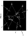
- FIG. 2 is an example display showing a composite view of the weather data aggregation in accordance with the principles of the present invention.
- FIG. 1 illustrates an airborne network of member aircraft, the aircraft designated generally as 10 , 10 ′, 12 , and 12 ′.
- the aircraft designated as 10 , 10 ′ are source/consumer aircraft which are each equipped with an airborne Weather Radar System (WRS) 14 , 14 ′.
- the consumer aircraft are not equipped with WRS's however they are suitably equipped to receive and process airborne Weather Radar Data. It is understood that although this figure shows only four aircraft there may be numerous aircraft in the airborne network.
- all member aircraft will be “consumer” aircraft. However, there may be cases where a member aircraft acts only as a conduit for moving airborne Weather Radar Data through the network even though it does not produce or consume the data. In general, most member aircraft will be source/consumer aircraft. However, it will be common for small aircraft (e.g., a general aviation aircraft) to participate only as consumer aircraft, thereby reaping the benefit of seeing airborne Weather Radar Data from larger aircraft (e.g., business, regional, and air transport aircraft).
- larger aircraft e.g., business, regional, and air transport aircraft.
- the weather data aggregation and display systems of the present invention are designated generally as 16 , 16 ′ for each respective source/consumer aircraft 10 , 10 ′.
- the respective weather data aggregation and display systems for consumer aircraft 12 , 12 ′ are designated generally as 18 , 18 ′.
- the weather data aggregation and display system 18 includes an airborne network system (ANS) 20 positioned on the member aircraft 12 adapted to receive incoming geo-referenced weather data 22 , 24 regarding Significant Meteorological Systems (SMS) from associated airborne network systems 26 , 26 ′ positioned on other member aircraft.
- ANS 20 is also adapted to re-transmit the incoming geo-referenced weather data to associated airborne network systems positioned on other member aircraft.
- the ANS 20 may be a broadband network such as a high bandwidth ad hoc network, HF/VHF ACARS (Aircraft Communications Addressing and Reporting System) network, or other emerging network service such as ConnexionTM by Boeing. There may be direct aircraft-to-aircraft communications or indirect communications via a ground station or satellite.
- HF/VHF ACARS Aircraft Communications Addressing and Reporting System
- ConnexionTM ConnexionTM by Boeing.
- a data processing system (DPS) 28 is coupled to the airborne network system 20 for generating the member aircraft's perspective of the Significant Meteorological Systems (SMS), based on the incoming weather data 29 and the member aircraft's navigation and attitude information.
- the DPS 28 provides DPS output weather data 30 .
- the DPS 28 is a graphics processing system and the weather data 30 provided is composite weather graphics.
- the composite weather graphics may be as defined in ARINC 708, ARINC 661, a next generation of ARINC 661 or equivalent, or any future suitable aviation standard.
- the composite weather graphics may also be defined in standardized commercial markup languages such as Hyper Text Markup Language (HTML), Standard Generalized Markup Language (SGML), eXtensible Markup Language (XML) or future standards.
- ARINC 708 uses angles, range bins and intensity levels to pass the weather radar information to a display.
- the display processes this data into a graphical image.
- Range bins go from near to far along the active pointing angle (specific ranges and sizes vary based on range settings). Intensities go from high to low and are associated with specific colors on the display (none, green, yellow, red, magenta).
- Some radars pre-process data or store data from multiple sweeps and generate ARINC 708 outputs that are filtered (to remove ground clutter for example) or used to identify additional hazards (windshear, turbulance).
- ARINC 661 is a more recent graphical interface standard for airplanes that defines a standardized Graphical User Interface between user applications and the airborne display system.
- the ARINC 661 Specification includes widgets (simple graphical objects and functions) that are used to manage dynamic map windows.
- the weather data may be standard weather graphics such as advisories, alerts, and advanced weather graphics. It may be ARINC 708 or 661 interface data and aircraft position and altitude data. Depending on the source radar system the data could be, for example, packaged ARINC 708 data, which would allow for development of a better composite data than an overlay/matchup of images. For more advanced source radars this may involve multiple sweeps of nearly the same area (“nearly the same” since the source is moving) in different operating modes/power settings. The data being sent is still formatted based on ARINC 708 but different meanings are assigned based on the mode. Instead of intensity (reflectivity) the range bins now are used to identify velocity (Doppler), likely turbulence or temperature. Or, the sweep angles may be vertical instead of horizontal which allows the development of a 3-D representation of the SMS.
- ARINC 708 or 661 interface data and aircraft position and altitude data.
- the data could be, for example, packaged ARINC 708 data, which would allow for development of a better
- An airborne display system (ADS) 32 is positioned on the member aircraft 12 and coupled to the data processing system 28 .
- the airborne display system 32 is adapted to receive the DPS output weather data 30 and in response thereto display desired weather imagery of the Significant Meteorological Systems (SMS).
- SMS Significant Meteorological Systems
- the ADS 32 may be, for example, what is referred to informally as a glass cockpit display system or more formally as an Electronic Flight Instrument System (EFIS). (A low cost albeit unlikely implementation may utilize a tablet PC.)
- EFIS Electronic Flight Instrument System
- the display of the baseline system is generally limited to a display of horizontal views of the storm from either the point of view of the consuming member aircraft or possibly a pilot selected position and orientation.
- the DPS 44 maintains a model (representation) of the SMS based on the received data and can present the pilot with different views/data, i.e. similar to what a radar system can do. This may include, for example, only displaying areas with likely turbulence, displaying cell tops, and/or vertical views of the SMS.
- An airborne navigation and attitude system (ANAS) 34 is optionally coupled to the DPS 28 and ANS 20 for sensing and distributing aircraft geo-referenced position (i.e. latitude, longitude, and altitude) and aircraft geo-referenced attitude (i.e. pitch, roll, and heading)
- ANAS output data 36 , 38 to the DPS 28 and the ANS 20 .
- ANAS 20 output data is used by the DPS 28 to rotate and/or translate weather information from multiple source aircraft so that the information can be combined, merged, or otherwise integrated. It is understood that the ANAS may comprise separate navigation and attitude systems.
- the source/consumer aircraft 10 , 10 ′ include weather radar systems 14 , 14 ′ in addition to the other elements noted above regarding the consumer aircraft 12 , 12 ′.
- the WRS 14 is coupled to the ANS 26 and provides WRS output data 40 for use by other aircraft in the airborne network.
- the WRS 14 may be coupled directly to the DPS 44 directly (as noted by numeral designation 44 ).
- the WRS 14 may be coupled to the DPS 44 via the ANS 26 which receives the DPS directed ANS output 46 .
- the weather radar system used may be of a type manufactured by present assignee such as the Collins WXR-2100 MultiScanTM Radar.
- the WRS 14 (when available/installed) is usually directly coupled with the ADS 42 (as shown by numeral designation 44 ) to provide cockpit weather data.
- the addition of the WRS 14 to the described consumer aircraft configuration will likely (but need not) include this direct coupling to the ADS 42 while also making weather data available to the ANS or the DPS.
- Each member aircraft is essentially a communications node that can not only transmit and receive local data but also re-transmit any received data to any other node (member). Thus, even if there is no direct RF path between members any communications node in the network can re-transmit any received data.
- communications nodes have been discussed with reference to aircraft there may be terrestrial nodes, space-based nodes, or maritime nodes.
- the optional use of the airborne navigation and attitude system (ANAS) 50 is as described above relative to the consumer aircraft 12 , 12 ′.
- consumer aircraft 12 In operation, in which there is no data forwarding, consumer aircraft 12 receives data from both source/consumer aircraft 10 , 10 ′, as indicated by numeral designations 22 and 24 . Consumer aircraft 12 ′ cannot receive data direct from source/consumer aircraft 10 (i.e. it is out of network range) so it has only partial data based on source/consumer aircraft 10 ′, as denoted by arrow 52 .
- consumer aircraft 12 receives data from both source/consumer aircraft 10 , 10 ′, as indicated by numeral designations 22 and 24 , as noted above.
- Consumer aircraft 12 ′ cannot receive data direct from source/consumer aircraft 10 (i.e. it is out of network range) but can get data from source/consumer aircraft 10 from either: 1) source/consumer aircraft 10 ′ (along with source/consumer aircraft 10 ′ data), as shown by arrows 54 and 56 ; or 2) consumer aircraft 12 , as shown by arrow 58 .
- source/consumer aircraft 10 ′ as long with source/consumer aircraft 10 ′ data
- consumer aircraft 12 as shown by arrow 58 .
- a display of a baseline version is illustrated, designated generally as 60 .
- This display 60 is generated by creating a composite image from geo-referenced images 62 , 64 , 66 , 68 .
- Each image is a view of the weather system (SMS) from a specific location.) Placing each view into a single image provides a composite view 60 . The view of the storm from the member aircraft can then be presented.
- SMS weather system
Abstract
Description
Claims (19)
Priority Applications (1)
| Application Number | Priority Date | Filing Date | Title |
|---|---|---|---|
| US11/014,118 US7633428B1 (en) | 2004-12-15 | 2004-12-15 | Weather data aggregation and display system for airborne network of member aircraft |
Applications Claiming Priority (1)
| Application Number | Priority Date | Filing Date | Title |
|---|---|---|---|
| US11/014,118 US7633428B1 (en) | 2004-12-15 | 2004-12-15 | Weather data aggregation and display system for airborne network of member aircraft |
Publications (1)
| Publication Number | Publication Date |
|---|---|
| US7633428B1 true US7633428B1 (en) | 2009-12-15 |
Family
ID=41403280
Family Applications (1)
| Application Number | Title | Priority Date | Filing Date |
|---|---|---|---|
| US11/014,118 Active 2025-08-09 US7633428B1 (en) | 2004-12-15 | 2004-12-15 | Weather data aggregation and display system for airborne network of member aircraft |
Country Status (1)
| Country | Link |
|---|---|
| US (1) | US7633428B1 (en) |
Cited By (78)
| Publication number | Priority date | Publication date | Assignee | Title |
|---|---|---|---|---|
| US20090012663A1 (en) * | 2007-03-16 | 2009-01-08 | Mead Robert W | Determining current meteorological conditions specific to an aircraft |
| US20100026523A1 (en) * | 2007-03-30 | 2010-02-04 | Honeywell International, Inc. | Aircraft systems with flight management systems that display reports |
| US20100042275A1 (en) * | 2008-08-18 | 2010-02-18 | Honeywell International Inc. | Systems and methods for generation of comprehensive airspace weather condition display from shared aircraft sensor data |
| US20100207809A1 (en) * | 2009-02-06 | 2010-08-19 | Takumi Fujikawa | Radar device and rain/snow area detecting device |
| US20100302093A1 (en) * | 2009-05-27 | 2010-12-02 | Honeywell International Inc. | Systems and methods for aircraft to aircraft exchange of radar information over low bandwidth communication channels |
| US20100302094A1 (en) * | 2009-06-02 | 2010-12-02 | Honeywell International Inc. | Systems and methods for using nexrad information to verify weather radar information |
| US20100311354A1 (en) * | 2007-04-24 | 2010-12-09 | Stayton Gregory T | Systems and methods for providing airborne aircraft weather reporting and supplemental occupant services |
| US20100315281A1 (en) * | 2009-06-10 | 2010-12-16 | The University Of North Dakota | Airspace risk mitigation system |
| US20100328143A1 (en) * | 2008-08-18 | 2010-12-30 | Honeywell International Inc. | Systems and methods for generation of comprehensive airspace weather condition display from shared aircraft sensor data by a transmitting aircraft |
| US20100332056A1 (en) * | 2008-08-18 | 2010-12-30 | Honeywell International Inc. | Systems and methods for generation of comprehensive airspace weather condition display from shared aircraft sensor data by a receiving aircraft |
| US20110001662A1 (en) * | 2009-07-03 | 2011-01-06 | Airbus Operations (Sas) | Process and a device for automatically determining meteorological conditions in the vicinity of an aircraft |
| US20110050458A1 (en) * | 2009-08-26 | 2011-03-03 | The Boeing Company | Dynamic environmental information transmission |
| US20110054718A1 (en) * | 2009-08-26 | 2011-03-03 | The Boeing Company | Dynamic weather selection |
| US20110074624A1 (en) * | 2009-09-30 | 2011-03-31 | Honeywell International Inc. | Systems and methods for preparing ground-based weather radar information for use in an installation vehicle |
| US20130079957A1 (en) * | 2011-09-23 | 2013-03-28 | Thales | Aerological Phenomena Alert Device for an Aircraft |
| US8495722B1 (en) | 2009-09-25 | 2013-07-23 | Rockwell Collins, Inc. | Method and system for controlling access to an aircraft-based wireless network |
| US8633913B1 (en) | 2011-09-02 | 2014-01-21 | Rockwell Collins, Inc. | Touch interfaces and controls for aviation displays |
| US20140197982A1 (en) * | 2013-01-15 | 2014-07-17 | Raytheon Canada Limited | System and method for social networking of aircraft for information exchange |
| WO2014111842A1 (en) * | 2013-01-15 | 2014-07-24 | Ti-Swiss Sa | Method to control a space including a plurality of mobile or not mobile stations |
| US8909471B1 (en) | 2011-09-30 | 2014-12-09 | Rockwell Collins, Inc. | Voting system and method using doppler aided navigation |
| US20150007080A1 (en) * | 2013-07-01 | 2015-01-01 | Honeywell International Inc. | System and method for producing and submitting a pirep |
| CN104267910A (en) * | 2014-08-19 | 2015-01-07 | 北京航空航天大学 | FPGA-based (field programmable gate array based) Arinc708 data processing IP (intellectual property) core design scheme |
| US8933836B1 (en) | 2011-09-30 | 2015-01-13 | Rockwell Collins, Inc. | High speed angle-to-target estimation for a multiple antenna system and method |
| FR3017763A1 (en) * | 2014-02-19 | 2015-08-21 | Sagem Defense Securite | DEVICE FOR TRANSMITTING DATA CONNECTED WITH A DISPLAY SYSTEM OF AN AIRCRAFT DRIVING UNIT |
| US9128594B1 (en) | 2011-09-02 | 2015-09-08 | Rockwell Collins, Inc. | Touch interfaces and controls for aviation displays |
| US20150276917A1 (en) * | 2012-11-02 | 2015-10-01 | Qinetiq Limited | Radar imaging system |
| US9223020B1 (en) * | 2010-09-28 | 2015-12-29 | Rockwell Collins, Inc. | System and method for weather detection using more than one source of radar data |
| US9244157B1 (en) | 2008-03-07 | 2016-01-26 | Rockwell Collins, Inc. | Weather radar threat depiction system and method |
| US9244167B1 (en) | 2008-03-07 | 2016-01-26 | Rockwell Collins, Inc. | Long range weather information display system and method |
| US9244166B1 (en) | 2008-03-07 | 2016-01-26 | Rockwell Collins, Inc. | System and method for ice detection |
| US9310477B1 (en) * | 2013-01-29 | 2016-04-12 | The Boeing Company | Systems and methods for monitoring airborne objects |
| US9322914B1 (en) | 2011-09-27 | 2016-04-26 | Rockwell Collins, Inc. | Aviation display depiction of weather threats |
| US9324236B2 (en) | 2011-11-23 | 2016-04-26 | The Boeing Company | System and methods for situation awareness, advisory, tracking, and aircraft control information |
| US9329266B2 (en) * | 2013-03-06 | 2016-05-03 | Kabushiki Kaisha Toshiba | Weather radar apparatus, observation sequence generation method, and observation sequence generation program |
| US9346556B2 (en) | 2012-07-31 | 2016-05-24 | General Electric Company | Method and apparatus for providing in-flight weather data |
| US9354633B1 (en) | 2008-10-31 | 2016-05-31 | Rockwell Collins, Inc. | System and method for ground navigation |
| US9384586B1 (en) | 2013-04-05 | 2016-07-05 | Rockwell Collins, Inc. | Enhanced flight vision system and method with radar sensing and pilot monitoring display |
| US9395438B1 (en) | 2003-07-31 | 2016-07-19 | Rockwell Collins, Inc. | System and method for turbulence detection |
| US9465097B2 (en) | 2008-04-17 | 2016-10-11 | Aviation Communication & Surveillance Systems Llc | Systems and methods for providing ADS-B mode control through data overlay |
| US9535158B1 (en) | 2013-11-21 | 2017-01-03 | Rockwell Collins, Inc. | Weather radar system and method with fusion of multiple weather information sources |
| US9562788B1 (en) | 2011-09-30 | 2017-02-07 | Rockwell Collins, Inc. | System and method for doppler aided navigation using weather radar |
| EP3128338A1 (en) * | 2015-08-07 | 2017-02-08 | Honeywell International Inc. | Aircraft weather radar coverage supplementing system |
| US9599707B1 (en) * | 2014-01-23 | 2017-03-21 | Rockwell Collins, Inc. | Weather radar system and method with path attenuation shadowing |
| US9607523B2 (en) | 2015-08-24 | 2017-03-28 | Honeywell International Inc. | Systems and methods for weather information management |
| US9672747B2 (en) | 2015-06-15 | 2017-06-06 | WxOps, Inc. | Common operating environment for aircraft operations |
| US9733349B1 (en) | 2007-09-06 | 2017-08-15 | Rockwell Collins, Inc. | System for and method of radar data processing for low visibility landing applications |
| US9791562B2 (en) | 2007-04-24 | 2017-10-17 | Aviation Communication & Surveillance Systems, Llc | Systems and methods for providing an ATC overlay data link |
| US9810770B1 (en) | 2014-07-03 | 2017-11-07 | Rockwell Collins, Inc. | Efficient retrieval of aviation data and weather over low bandwidth links |
| CN107340519A (en) * | 2017-07-02 | 2017-11-10 | 中国航空工业集团公司雷华电子技术研究所 | A kind of weather radar rainfall detecting analytic system and method |
| US9823347B1 (en) | 2014-03-12 | 2017-11-21 | Rockwell Collins, Inc. | Weather radar system and method for high altitude crystal warning interface |
| US9846230B1 (en) * | 2013-03-15 | 2017-12-19 | Rockwell Collins, Inc. | System and method for ice detection |
| US9864055B1 (en) | 2014-03-12 | 2018-01-09 | Rockwell Collins, Inc. | Weather radar system and method for detecting a high altitude crystal cloud condition |
| US9869766B1 (en) | 2015-01-28 | 2018-01-16 | Rockwell Collins, Inc. | Enhancement of airborne weather radar performance using external weather data |
| US9939526B2 (en) | 2007-09-06 | 2018-04-10 | Rockwell Collins, Inc. | Display system and method using weather radar sensing |
| US9949201B2 (en) | 2015-09-25 | 2018-04-17 | Honeywell International Inc. | Systems and methods for regulating weather information collection |
| US9967707B2 (en) | 2014-04-16 | 2018-05-08 | Honeywell International Inc. | Weather data dissemination |
| US20180172800A1 (en) * | 2016-12-16 | 2018-06-21 | Honeywell International Inc. | Automatic uplink weather information sharing |
| US10102759B2 (en) | 2015-09-25 | 2018-10-16 | Honeywell International Inc. | Systems and methods for collecting weather information for selected airspace regions |
| US10139474B2 (en) | 2017-02-22 | 2018-11-27 | Honeywell International Inc. | Methods and systems for providing live weather data onboard an aircraft |
| US10151834B2 (en) | 2016-07-26 | 2018-12-11 | Honeywell International Inc. | Weather data de-conflicting and correction system |
| CN109120331A (en) * | 2018-09-18 | 2019-01-01 | 福建鼎旸信息科技股份有限公司 | General Aviation satellite and wireless fusion earth-space communication command system and method |
| US10228460B1 (en) | 2016-05-26 | 2019-03-12 | Rockwell Collins, Inc. | Weather radar enabled low visibility operation system and method |
| US10247821B1 (en) * | 2017-08-04 | 2019-04-02 | Rockwell Collins, Inc. | Panoramic weather radar display system for aircraft |
| US10257278B2 (en) | 2016-01-27 | 2019-04-09 | Honeywell International Inc. | Vehicle defined source transmitter |
| US10302815B1 (en) | 2015-10-01 | 2019-05-28 | Rockwell Collins, Inc. | System and method of integrating global convective weather |
| US20190188335A1 (en) * | 2017-12-15 | 2019-06-20 | The Boeing Company | Lineal data storage and retrieval system |
| US10353068B1 (en) | 2016-07-28 | 2019-07-16 | Rockwell Collins, Inc. | Weather radar enabled offshore operation system and method |
| US10459078B2 (en) | 2016-09-13 | 2019-10-29 | Honeywell International Inc. | Reliability index for weather information |
| US10494108B1 (en) | 2016-05-17 | 2019-12-03 | Rockwell Collins, Inc. | System and method for providing icing condition warnings |
| US10585189B1 (en) * | 2011-09-20 | 2020-03-10 | Rockwell Collins, Inc. | Sharing air data between aircraft for threat detection |
| US10705201B1 (en) | 2015-08-31 | 2020-07-07 | Rockwell Collins, Inc. | Radar beam sharpening system and method |
| US10809375B1 (en) | 2015-09-14 | 2020-10-20 | Rockwell Collins, Inc. | Radar system and method for detecting hazards associated with particles or bodies |
| US20200334995A1 (en) * | 2019-04-19 | 2020-10-22 | Thales | Distributed registers for the management of weather data in aeronautics |
| US10928510B1 (en) | 2014-09-10 | 2021-02-23 | Rockwell Collins, Inc. | System for and method of image processing for low visibility landing applications |
| US11157476B2 (en) | 2015-04-15 | 2021-10-26 | Honeywell International Inc. | Marine weather radar and sea state data aggregating system |
| US11341861B2 (en) | 2018-11-07 | 2022-05-24 | Honeywell International Inc. | Methods and systems for relevance determination of shared environmental data based on vehicle context |
| US11467249B2 (en) | 2007-04-24 | 2022-10-11 | Aviation Communication & Surveillance Systems Llc | Interval management using data overlay |
| US20230066768A1 (en) * | 2021-08-25 | 2023-03-02 | Rockwell Collins, Inc. | Airborne sensor to sensor information sharing technique |
Citations (20)
| Publication number | Priority date | Publication date | Assignee | Title |
|---|---|---|---|---|
| US5493309A (en) * | 1993-09-24 | 1996-02-20 | Motorola, Inc. | Collison avoidance communication system and method |
| US6043756A (en) * | 1998-02-09 | 2000-03-28 | Alliedsignal Inc. | Aircraft weather information system |
| US6201494B1 (en) * | 1999-07-30 | 2001-03-13 | Rockwell Collins, Inc. | Automatic storm finding weather radar |
| US6381538B1 (en) * | 2000-05-26 | 2002-04-30 | Aerotech Research (U.S.A.), Inc. | Vehicle specific hazard estimation, presentation, and route planning based on meteorological and other environmental data |
| US6441773B1 (en) * | 2000-08-24 | 2002-08-27 | Rockwell Collins, Inc. | Weather radar system integrating ground-based weather radar with on-board aircraft weather radar |
| US6448922B1 (en) * | 2000-08-24 | 2002-09-10 | Rockwell Collins, Inc. | Retrofit solution for the integration of ground-based weather radar images with on-board weather radar |
| US6501392B2 (en) * | 1998-02-09 | 2002-12-31 | Honeywell International Inc. | Aircraft weather information system |
| US6577947B1 (en) * | 2002-03-01 | 2003-06-10 | Rockwell Collins, Inc. | Method and apparatus for identification of hazards along an intended travel route |
| US6650972B1 (en) * | 2000-05-26 | 2003-11-18 | Aerotech Research (U.S.A.), Inc. | Estimation, transmission, receipt, and presentation of vehicle specific environmental conditions and hazards information |
| US6667710B2 (en) * | 2001-06-29 | 2003-12-23 | Honeywell International Inc. | 3-D weather buffer display system |
| US6694249B1 (en) * | 2002-01-11 | 2004-02-17 | Rockwell Collins | Integrated surface moving map advisory system |
| US6744382B1 (en) * | 2002-04-19 | 2004-06-01 | Rockwell Collins | Method and apparatus for guiding an aircraft through a cluster of hazardous areas |
| US6751532B2 (en) * | 2001-07-05 | 2004-06-15 | National Aerospace Laboratory Of Japan | Wind turbulence prediction system |
| US6828922B1 (en) * | 1998-02-09 | 2004-12-07 | Honeywell International Inc. | Synthetic airborne hazard display |
| US6865452B2 (en) * | 2002-08-30 | 2005-03-08 | Honeywell International Inc. | Quiet mode operation for cockpit weather displays |
| US6867727B1 (en) * | 2004-03-01 | 2005-03-15 | The United States Of America As Represented By The Secretary Of The Air Force | Multiplatform multifunction avionics architecture |
| US6937937B1 (en) * | 2004-05-28 | 2005-08-30 | Honeywell International Inc. | Airborne based monitoring |
| US6977608B1 (en) * | 2004-12-15 | 2005-12-20 | Rockwell Collins | Atmospheric data aggregation and forecasting system |
| US7069147B2 (en) * | 2004-05-28 | 2006-06-27 | Honeywell International Inc. | Airborne based monitoring |
| US20060155432A1 (en) * | 2005-01-07 | 2006-07-13 | United Technologies Corporation | Methods and systems for monitoring atmospheric conditions, predicting turbulent atmospheric conditions and optimizing flight paths of aircraft |
-
2004
- 2004-12-15 US US11/014,118 patent/US7633428B1/en active Active
Patent Citations (20)
| Publication number | Priority date | Publication date | Assignee | Title |
|---|---|---|---|---|
| US5493309A (en) * | 1993-09-24 | 1996-02-20 | Motorola, Inc. | Collison avoidance communication system and method |
| US6043756A (en) * | 1998-02-09 | 2000-03-28 | Alliedsignal Inc. | Aircraft weather information system |
| US6501392B2 (en) * | 1998-02-09 | 2002-12-31 | Honeywell International Inc. | Aircraft weather information system |
| US6828922B1 (en) * | 1998-02-09 | 2004-12-07 | Honeywell International Inc. | Synthetic airborne hazard display |
| US6201494B1 (en) * | 1999-07-30 | 2001-03-13 | Rockwell Collins, Inc. | Automatic storm finding weather radar |
| US6381538B1 (en) * | 2000-05-26 | 2002-04-30 | Aerotech Research (U.S.A.), Inc. | Vehicle specific hazard estimation, presentation, and route planning based on meteorological and other environmental data |
| US6650972B1 (en) * | 2000-05-26 | 2003-11-18 | Aerotech Research (U.S.A.), Inc. | Estimation, transmission, receipt, and presentation of vehicle specific environmental conditions and hazards information |
| US6441773B1 (en) * | 2000-08-24 | 2002-08-27 | Rockwell Collins, Inc. | Weather radar system integrating ground-based weather radar with on-board aircraft weather radar |
| US6448922B1 (en) * | 2000-08-24 | 2002-09-10 | Rockwell Collins, Inc. | Retrofit solution for the integration of ground-based weather radar images with on-board weather radar |
| US6667710B2 (en) * | 2001-06-29 | 2003-12-23 | Honeywell International Inc. | 3-D weather buffer display system |
| US6751532B2 (en) * | 2001-07-05 | 2004-06-15 | National Aerospace Laboratory Of Japan | Wind turbulence prediction system |
| US6694249B1 (en) * | 2002-01-11 | 2004-02-17 | Rockwell Collins | Integrated surface moving map advisory system |
| US6577947B1 (en) * | 2002-03-01 | 2003-06-10 | Rockwell Collins, Inc. | Method and apparatus for identification of hazards along an intended travel route |
| US6744382B1 (en) * | 2002-04-19 | 2004-06-01 | Rockwell Collins | Method and apparatus for guiding an aircraft through a cluster of hazardous areas |
| US6865452B2 (en) * | 2002-08-30 | 2005-03-08 | Honeywell International Inc. | Quiet mode operation for cockpit weather displays |
| US6867727B1 (en) * | 2004-03-01 | 2005-03-15 | The United States Of America As Represented By The Secretary Of The Air Force | Multiplatform multifunction avionics architecture |
| US6937937B1 (en) * | 2004-05-28 | 2005-08-30 | Honeywell International Inc. | Airborne based monitoring |
| US7069147B2 (en) * | 2004-05-28 | 2006-06-27 | Honeywell International Inc. | Airborne based monitoring |
| US6977608B1 (en) * | 2004-12-15 | 2005-12-20 | Rockwell Collins | Atmospheric data aggregation and forecasting system |
| US20060155432A1 (en) * | 2005-01-07 | 2006-07-13 | United Technologies Corporation | Methods and systems for monitoring atmospheric conditions, predicting turbulent atmospheric conditions and optimizing flight paths of aircraft |
Non-Patent Citations (2)
| Title |
|---|
| Airlines Electronic Engineering Committee; Airborne Weather Radar; ARINC Characteristic 708-6; Nov. 15, 1991; pp. 64-71 (Attachment 15). |
| http://en.wikipedia.org/wiki/ARINC-708; ARINC 708; Printed Apr. 1, 2009; 2 Pages. |
Cited By (121)
| Publication number | Priority date | Publication date | Assignee | Title |
|---|---|---|---|---|
| US9395438B1 (en) | 2003-07-31 | 2016-07-19 | Rockwell Collins, Inc. | System and method for turbulence detection |
| US20090012663A1 (en) * | 2007-03-16 | 2009-01-08 | Mead Robert W | Determining current meteorological conditions specific to an aircraft |
| US8437893B2 (en) * | 2007-03-16 | 2013-05-07 | The Boeing Company | Determining current meteorological conditions specific to an aircraft |
| US20100026523A1 (en) * | 2007-03-30 | 2010-02-04 | Honeywell International, Inc. | Aircraft systems with flight management systems that display reports |
| US8330625B2 (en) * | 2007-03-30 | 2012-12-11 | Honeywell International Inc. | Aircraft systems with flight management systems that display reports |
| US11430340B2 (en) * | 2007-04-24 | 2022-08-30 | Aviation Communication & Surveillance Systems Llc | Systems and methods for providing airborne aircraft weather reporting and supplemental occupant services |
| US20100311354A1 (en) * | 2007-04-24 | 2010-12-09 | Stayton Gregory T | Systems and methods for providing airborne aircraft weather reporting and supplemental occupant services |
| US9791562B2 (en) | 2007-04-24 | 2017-10-17 | Aviation Communication & Surveillance Systems, Llc | Systems and methods for providing an ATC overlay data link |
| US11467249B2 (en) | 2007-04-24 | 2022-10-11 | Aviation Communication & Surveillance Systems Llc | Interval management using data overlay |
| US9733349B1 (en) | 2007-09-06 | 2017-08-15 | Rockwell Collins, Inc. | System for and method of radar data processing for low visibility landing applications |
| US9939526B2 (en) | 2007-09-06 | 2018-04-10 | Rockwell Collins, Inc. | Display system and method using weather radar sensing |
| US9612328B1 (en) | 2008-03-07 | 2017-04-04 | Rockwell Collins, Inc. | Weather radar system and method for estimating vertically integrated liquid content |
| US10302761B1 (en) | 2008-03-07 | 2019-05-28 | Rockwell Collins, Inc. | System and method for turbulence detection |
| US9244167B1 (en) | 2008-03-07 | 2016-01-26 | Rockwell Collins, Inc. | Long range weather information display system and method |
| US11131771B1 (en) | 2008-03-07 | 2021-09-28 | Rockwell Collins, Inc. | System and method for turbulence detection |
| US11933890B2 (en) | 2008-03-07 | 2024-03-19 | Rockwell Collins, Inc. | System and method for turbulence detection |
| US9244157B1 (en) | 2008-03-07 | 2016-01-26 | Rockwell Collins, Inc. | Weather radar threat depiction system and method |
| US9244166B1 (en) | 2008-03-07 | 2016-01-26 | Rockwell Collins, Inc. | System and method for ice detection |
| US9507022B1 (en) | 2008-03-07 | 2016-11-29 | Rockwell Collins, Inc. | Weather radar system and method for estimating vertically integrated liquid content |
| US9465097B2 (en) | 2008-04-17 | 2016-10-11 | Aviation Communication & Surveillance Systems Llc | Systems and methods for providing ADS-B mode control through data overlay |
| US20100332056A1 (en) * | 2008-08-18 | 2010-12-30 | Honeywell International Inc. | Systems and methods for generation of comprehensive airspace weather condition display from shared aircraft sensor data by a receiving aircraft |
| US20100042275A1 (en) * | 2008-08-18 | 2010-02-18 | Honeywell International Inc. | Systems and methods for generation of comprehensive airspace weather condition display from shared aircraft sensor data |
| US8903571B2 (en) | 2008-08-18 | 2014-12-02 | Honeywell International Inc. | Systems and methods for generation of comprehensive airspace weather condition display from shared aircraft sensor data |
| US8217828B2 (en) * | 2008-08-18 | 2012-07-10 | Honeywell International Inc. | Systems and methods for generation of comprehensive airspace weather condition display from shared aircraft sensor data by a transmitting aircraft |
| US20100328143A1 (en) * | 2008-08-18 | 2010-12-30 | Honeywell International Inc. | Systems and methods for generation of comprehensive airspace weather condition display from shared aircraft sensor data by a transmitting aircraft |
| US9354633B1 (en) | 2008-10-31 | 2016-05-31 | Rockwell Collins, Inc. | System and method for ground navigation |
| US20100207809A1 (en) * | 2009-02-06 | 2010-08-19 | Takumi Fujikawa | Radar device and rain/snow area detecting device |
| US8264395B2 (en) * | 2009-02-06 | 2012-09-11 | Furuno Electric Company, Limited | Radar device and rain/snow area detecting device |
| US20100302093A1 (en) * | 2009-05-27 | 2010-12-02 | Honeywell International Inc. | Systems and methods for aircraft to aircraft exchange of radar information over low bandwidth communication channels |
| EP2256957B1 (en) * | 2009-05-27 | 2017-09-27 | Honeywell International Inc. | Systems and methods for aircraft to aircraft exchange of radar information over low bandwidth communication channels |
| US8223062B2 (en) * | 2009-05-27 | 2012-07-17 | Honeywell International Inc. | Systems and methods for aircraft to aircraft exchange of radar information over low bandwidth communication channels |
| US20100302094A1 (en) * | 2009-06-02 | 2010-12-02 | Honeywell International Inc. | Systems and methods for using nexrad information to verify weather radar information |
| US8022859B2 (en) * | 2009-06-02 | 2011-09-20 | Honeywell International Inc. | Systems and methods for using nexrad information to verify weather radar information |
| US8368584B2 (en) * | 2009-06-10 | 2013-02-05 | The University Of North Dakota | Airspace risk mitigation system |
| US20100315281A1 (en) * | 2009-06-10 | 2010-12-16 | The University Of North Dakota | Airspace risk mitigation system |
| US8350748B2 (en) * | 2009-07-03 | 2013-01-08 | Airbus Operations (Sas) | Process and a device for automatically determining meteorological conditions in the vicinity of an aircraft |
| US20110001662A1 (en) * | 2009-07-03 | 2011-01-06 | Airbus Operations (Sas) | Process and a device for automatically determining meteorological conditions in the vicinity of an aircraft |
| US8165790B2 (en) * | 2009-08-26 | 2012-04-24 | The Boeing Company | Dynamic weather selection |
| US8788188B1 (en) | 2009-08-26 | 2014-07-22 | The Boeing Company | Dynamic weather selection |
| US8416099B2 (en) | 2009-08-26 | 2013-04-09 | The Boeing Company | Dynamic environmental information transmission |
| US20110050458A1 (en) * | 2009-08-26 | 2011-03-03 | The Boeing Company | Dynamic environmental information transmission |
| US20110054718A1 (en) * | 2009-08-26 | 2011-03-03 | The Boeing Company | Dynamic weather selection |
| US8495722B1 (en) | 2009-09-25 | 2013-07-23 | Rockwell Collins, Inc. | Method and system for controlling access to an aircraft-based wireless network |
| US8054214B2 (en) * | 2009-09-30 | 2011-11-08 | Honeywell International Inc. | Systems and methods for preparing ground-based weather radar information for use in an installation vehicle |
| US20110074624A1 (en) * | 2009-09-30 | 2011-03-31 | Honeywell International Inc. | Systems and methods for preparing ground-based weather radar information for use in an installation vehicle |
| US9223020B1 (en) * | 2010-09-28 | 2015-12-29 | Rockwell Collins, Inc. | System and method for weather detection using more than one source of radar data |
| US9128594B1 (en) | 2011-09-02 | 2015-09-08 | Rockwell Collins, Inc. | Touch interfaces and controls for aviation displays |
| US8633913B1 (en) | 2011-09-02 | 2014-01-21 | Rockwell Collins, Inc. | Touch interfaces and controls for aviation displays |
| US9007327B1 (en) | 2011-09-02 | 2015-04-14 | Rockwell Collins, Inc. | Touch interfaces and controls for aviation displays |
| US10585189B1 (en) * | 2011-09-20 | 2020-03-10 | Rockwell Collins, Inc. | Sharing air data between aircraft for threat detection |
| FR2980585A1 (en) * | 2011-09-23 | 2013-03-29 | Thales Sa | DEVICE FOR ALERTING AEROLOGICAL PHENOMENA FOR AN AIRCRAFT |
| US20130079957A1 (en) * | 2011-09-23 | 2013-03-28 | Thales | Aerological Phenomena Alert Device for an Aircraft |
| US8965602B2 (en) * | 2011-09-23 | 2015-02-24 | Thales | Aerological phenomena alert device for an aircraft |
| US10685469B1 (en) | 2011-09-27 | 2020-06-16 | Rockwell Collins, Inc. | Aviation display depiction of weather threats |
| US9720082B1 (en) | 2011-09-27 | 2017-08-01 | Rockwell Collins, Inc. | Weather radar system and method for detecting a high altitude crystal condition using two or more types of radar signals |
| US9322914B1 (en) | 2011-09-27 | 2016-04-26 | Rockwell Collins, Inc. | Aviation display depiction of weather threats |
| US9625577B1 (en) | 2011-09-27 | 2017-04-18 | Rockwell Collins, Inc. | Aviation display depiction of weather threats |
| US9978168B1 (en) | 2011-09-27 | 2018-05-22 | Rockwell Collins, Inc. | Aviation display depiction of weather threats |
| US8933836B1 (en) | 2011-09-30 | 2015-01-13 | Rockwell Collins, Inc. | High speed angle-to-target estimation for a multiple antenna system and method |
| US9562788B1 (en) | 2011-09-30 | 2017-02-07 | Rockwell Collins, Inc. | System and method for doppler aided navigation using weather radar |
| US8909471B1 (en) | 2011-09-30 | 2014-12-09 | Rockwell Collins, Inc. | Voting system and method using doppler aided navigation |
| US9324236B2 (en) | 2011-11-23 | 2016-04-26 | The Boeing Company | System and methods for situation awareness, advisory, tracking, and aircraft control information |
| US9346556B2 (en) | 2012-07-31 | 2016-05-24 | General Electric Company | Method and apparatus for providing in-flight weather data |
| US10502821B2 (en) * | 2012-11-02 | 2019-12-10 | Qinetiq Limited | Radar imaging system |
| US20150276917A1 (en) * | 2012-11-02 | 2015-10-01 | Qinetiq Limited | Radar imaging system |
| US20140197982A1 (en) * | 2013-01-15 | 2014-07-17 | Raytheon Canada Limited | System and method for social networking of aircraft for information exchange |
| WO2014111842A1 (en) * | 2013-01-15 | 2014-07-24 | Ti-Swiss Sa | Method to control a space including a plurality of mobile or not mobile stations |
| US9208687B2 (en) * | 2013-01-15 | 2015-12-08 | Raytheon Canada Limited | System and method for social networking of aircraft for information exchange |
| US9310477B1 (en) * | 2013-01-29 | 2016-04-12 | The Boeing Company | Systems and methods for monitoring airborne objects |
| US9329266B2 (en) * | 2013-03-06 | 2016-05-03 | Kabushiki Kaisha Toshiba | Weather radar apparatus, observation sequence generation method, and observation sequence generation program |
| US9846230B1 (en) * | 2013-03-15 | 2017-12-19 | Rockwell Collins, Inc. | System and method for ice detection |
| US9384586B1 (en) | 2013-04-05 | 2016-07-05 | Rockwell Collins, Inc. | Enhanced flight vision system and method with radar sensing and pilot monitoring display |
| US20150007080A1 (en) * | 2013-07-01 | 2015-01-01 | Honeywell International Inc. | System and method for producing and submitting a pirep |
| US10296179B2 (en) * | 2013-07-01 | 2019-05-21 | Honeywell International Inc. | System and method for producing and submitting a PIREP |
| US9535158B1 (en) | 2013-11-21 | 2017-01-03 | Rockwell Collins, Inc. | Weather radar system and method with fusion of multiple weather information sources |
| US9689984B1 (en) | 2013-11-21 | 2017-06-27 | Rockwell Collins, Inc. | Weather radar system and method with latency compensation for data link weather information |
| US9599707B1 (en) * | 2014-01-23 | 2017-03-21 | Rockwell Collins, Inc. | Weather radar system and method with path attenuation shadowing |
| US10684366B1 (en) | 2014-01-23 | 2020-06-16 | Rockwell Collins, Inc. | Weather radar system and method with path attenuation shadowing |
| FR3017763A1 (en) * | 2014-02-19 | 2015-08-21 | Sagem Defense Securite | DEVICE FOR TRANSMITTING DATA CONNECTED WITH A DISPLAY SYSTEM OF AN AIRCRAFT DRIVING UNIT |
| US9864055B1 (en) | 2014-03-12 | 2018-01-09 | Rockwell Collins, Inc. | Weather radar system and method for detecting a high altitude crystal cloud condition |
| US9823347B1 (en) | 2014-03-12 | 2017-11-21 | Rockwell Collins, Inc. | Weather radar system and method for high altitude crystal warning interface |
| US9967707B2 (en) | 2014-04-16 | 2018-05-08 | Honeywell International Inc. | Weather data dissemination |
| US9810770B1 (en) | 2014-07-03 | 2017-11-07 | Rockwell Collins, Inc. | Efficient retrieval of aviation data and weather over low bandwidth links |
| CN104267910A (en) * | 2014-08-19 | 2015-01-07 | 北京航空航天大学 | FPGA-based (field programmable gate array based) Arinc708 data processing IP (intellectual property) core design scheme |
| CN104267910B (en) * | 2014-08-19 | 2017-05-24 | 北京航空航天大学 | FPGA-based (field programmable gate array based) Arinc708 data processing IP (intellectual property) core design method |
| US10928510B1 (en) | 2014-09-10 | 2021-02-23 | Rockwell Collins, Inc. | System for and method of image processing for low visibility landing applications |
| US9869766B1 (en) | 2015-01-28 | 2018-01-16 | Rockwell Collins, Inc. | Enhancement of airborne weather radar performance using external weather data |
| US11157476B2 (en) | 2015-04-15 | 2021-10-26 | Honeywell International Inc. | Marine weather radar and sea state data aggregating system |
| US9916764B2 (en) | 2015-06-15 | 2018-03-13 | Wxpos, Inc. | Common operating environment for aircraft operations with air-to-air communication |
| US9672747B2 (en) | 2015-06-15 | 2017-06-06 | WxOps, Inc. | Common operating environment for aircraft operations |
| EP3128338A1 (en) * | 2015-08-07 | 2017-02-08 | Honeywell International Inc. | Aircraft weather radar coverage supplementing system |
| US9952310B2 (en) | 2015-08-07 | 2018-04-24 | Honeywell International Inc. | Aircraft weather radar coverage supplementing system |
| US9607523B2 (en) | 2015-08-24 | 2017-03-28 | Honeywell International Inc. | Systems and methods for weather information management |
| US10705201B1 (en) | 2015-08-31 | 2020-07-07 | Rockwell Collins, Inc. | Radar beam sharpening system and method |
| US11402498B1 (en) | 2015-09-14 | 2022-08-02 | Rockwell Collins, Inc. | Radar system and method for detecting hazards associated with particles or bodies |
| US10809375B1 (en) | 2015-09-14 | 2020-10-20 | Rockwell Collins, Inc. | Radar system and method for detecting hazards associated with particles or bodies |
| US9949201B2 (en) | 2015-09-25 | 2018-04-17 | Honeywell International Inc. | Systems and methods for regulating weather information collection |
| US10102759B2 (en) | 2015-09-25 | 2018-10-16 | Honeywell International Inc. | Systems and methods for collecting weather information for selected airspace regions |
| US10796588B2 (en) | 2015-09-25 | 2020-10-06 | Honeywell International Inc. | Systems and methods for collecting weather information for selected airspace regions |
| US10302815B1 (en) | 2015-10-01 | 2019-05-28 | Rockwell Collins, Inc. | System and method of integrating global convective weather |
| US10728341B2 (en) | 2016-01-27 | 2020-07-28 | Honeywell International Inc. | Vehicle defined source transmitter |
| US10257278B2 (en) | 2016-01-27 | 2019-04-09 | Honeywell International Inc. | Vehicle defined source transmitter |
| US10494108B1 (en) | 2016-05-17 | 2019-12-03 | Rockwell Collins, Inc. | System and method for providing icing condition warnings |
| US10228460B1 (en) | 2016-05-26 | 2019-03-12 | Rockwell Collins, Inc. | Weather radar enabled low visibility operation system and method |
| US10955548B1 (en) | 2016-05-26 | 2021-03-23 | Rockwell Collins, Inc. | Weather radar enabled low visibility operation system and method |
| US10151834B2 (en) | 2016-07-26 | 2018-12-11 | Honeywell International Inc. | Weather data de-conflicting and correction system |
| US10353068B1 (en) | 2016-07-28 | 2019-07-16 | Rockwell Collins, Inc. | Weather radar enabled offshore operation system and method |
| US10459078B2 (en) | 2016-09-13 | 2019-10-29 | Honeywell International Inc. | Reliability index for weather information |
| US20180172800A1 (en) * | 2016-12-16 | 2018-06-21 | Honeywell International Inc. | Automatic uplink weather information sharing |
| US10761207B2 (en) * | 2016-12-16 | 2020-09-01 | Honeywell International Inc. | Automatic uplink weather information sharing |
| US10139474B2 (en) | 2017-02-22 | 2018-11-27 | Honeywell International Inc. | Methods and systems for providing live weather data onboard an aircraft |
| CN107340519B (en) * | 2017-07-02 | 2021-02-19 | 中国航空工业集团公司雷华电子技术研究所 | Weather radar rainfall detection analysis system and method |
| CN107340519A (en) * | 2017-07-02 | 2017-11-10 | 中国航空工业集团公司雷华电子技术研究所 | A kind of weather radar rainfall detecting analytic system and method |
| US10247821B1 (en) * | 2017-08-04 | 2019-04-02 | Rockwell Collins, Inc. | Panoramic weather radar display system for aircraft |
| US10803128B2 (en) * | 2017-12-15 | 2020-10-13 | The Boeing Company | Lineal data storage and retrieval system |
| US20190188335A1 (en) * | 2017-12-15 | 2019-06-20 | The Boeing Company | Lineal data storage and retrieval system |
| CN109120331A (en) * | 2018-09-18 | 2019-01-01 | 福建鼎旸信息科技股份有限公司 | General Aviation satellite and wireless fusion earth-space communication command system and method |
| CN109120331B (en) * | 2018-09-18 | 2022-03-25 | 福建鼎旸信息科技股份有限公司 | General aviation satellite and wireless fusion ground-air communication command system and method |
| US11341861B2 (en) | 2018-11-07 | 2022-05-24 | Honeywell International Inc. | Methods and systems for relevance determination of shared environmental data based on vehicle context |
| US20200334995A1 (en) * | 2019-04-19 | 2020-10-22 | Thales | Distributed registers for the management of weather data in aeronautics |
| US20230066768A1 (en) * | 2021-08-25 | 2023-03-02 | Rockwell Collins, Inc. | Airborne sensor to sensor information sharing technique |
Similar Documents
| Publication | Publication Date | Title |
|---|---|---|
| US7633428B1 (en) | Weather data aggregation and display system for airborne network of member aircraft | |
| US10175353B2 (en) | Enhancement of airborne weather radar performance using external weather data | |
| US8022859B2 (en) | Systems and methods for using nexrad information to verify weather radar information | |
| US5936552A (en) | Integrated horizontal and profile terrain display format for situational awareness | |
| US6977608B1 (en) | Atmospheric data aggregation and forecasting system | |
| US11588543B2 (en) | Requesting weather data based on pre-selected events | |
| EP3067710B1 (en) | Weather radar integrating system combining aircraft-based weather radar data | |
| US9869766B1 (en) | Enhancement of airborne weather radar performance using external weather data | |
| US6501392B2 (en) | Aircraft weather information system | |
| US7817078B2 (en) | Systems and methods for supplemental weather information presentation on a display | |
| US6828922B1 (en) | Synthetic airborne hazard display | |
| US6441773B1 (en) | Weather radar system integrating ground-based weather radar with on-board aircraft weather radar | |
| EP1055136B1 (en) | Aircraft weather information system | |
| US8159369B1 (en) | Weather radar system and method | |
| US5657009A (en) | System for detecting and viewing aircraft-hazardous incidents that may be encountered by aircraft landing or taking-off | |
| US11181634B1 (en) | Systems and methods of intelligent weather sensing using deep learning convolutional neural networks | |
| US10605912B1 (en) | Storm top adaptive beam scan | |
| US9823347B1 (en) | Weather radar system and method for high altitude crystal warning interface | |
| US8249806B1 (en) | System, module, and method for varying the intensity of a visual aid depicted on an aircraft display unit | |
| Bailey et al. | Aspects of synthetic vision display systems and the best practices of the NASA's SVS project | |
| US20230222922A1 (en) | Optimized weather and threat depiction based on aircraft flight plan | |
| Kelly et al. | Cockpit integration of uplinked weather radar imagery | |
| Zelenka et al. | Flight Test of 35GHz MMW Radar Forward Sensor for Collision Avoidance | |
| Thomson et al. | Precision Four-Dimensional Digital Mapping Teaches Humans and Machines to See In the Dark | |
| Craig et al. | Remote detection and real-time alerting for in-cloud turbulence |
Legal Events
| Date | Code | Title | Description |
|---|---|---|---|
| AS | Assignment |
Owner name: ROCKWELL COLLINS, INC., IOWA Free format text: ASSIGNMENT OF ASSIGNORS INTEREST;ASSIGNOR:MCCUSKER, PATRICK D.;REEL/FRAME:016106/0186 Effective date: 20041214 Owner name: ROCKWELL COLLINS, INC., IOWA Free format text: ASSIGNMENT OF ASSIGNORS INTEREST;ASSIGNOR:ANDERSON, ERIC N.;REEL/FRAME:016106/0199 Effective date: 20041214 |
|
| STCF | Information on status: patent grant |
Free format text: PATENTED CASE |
|
| FPAY | Fee payment |
Year of fee payment: 4 |
|
| FPAY | Fee payment |
Year of fee payment: 8 |
|
| MAFP | Maintenance fee payment |
Free format text: PAYMENT OF MAINTENANCE FEE, 12TH YEAR, LARGE ENTITY (ORIGINAL EVENT CODE: M1553); ENTITY STATUS OF PATENT OWNER: LARGE ENTITY Year of fee payment: 12 |