US7010567B1 - Map-data distribution method, and map-data distribution server and client - Google Patents
Map-data distribution method, and map-data distribution server and client Download PDFInfo
- Publication number
- US7010567B1 US7010567B1 US09/642,739 US64273900A US7010567B1 US 7010567 B1 US7010567 B1 US 7010567B1 US 64273900 A US64273900 A US 64273900A US 7010567 B1 US7010567 B1 US 7010567B1
- Authority
- US
- United States
- Prior art keywords
- map
- data
- client
- component
- image
- Prior art date
- Legal status (The legal status is an assumption and is not a legal conclusion. Google has not performed a legal analysis and makes no representation as to the accuracy of the status listed.)
- Expired - Lifetime, expires
Links
Images


Classifications
-
- G—PHYSICS
- G09—EDUCATION; CRYPTOGRAPHY; DISPLAY; ADVERTISING; SEALS
- G09B—EDUCATIONAL OR DEMONSTRATION APPLIANCES; APPLIANCES FOR TEACHING, OR COMMUNICATING WITH, THE BLIND, DEAF OR MUTE; MODELS; PLANETARIA; GLOBES; MAPS; DIAGRAMS
- G09B29/00—Maps; Plans; Charts; Diagrams, e.g. route diagram
- G09B29/10—Map spot or coordinate position indicators; Map reading aids
- G09B29/106—Map spot or coordinate position indicators; Map reading aids using electronic means
-
- G—PHYSICS
- G01—MEASURING; TESTING
- G01C—MEASURING DISTANCES, LEVELS OR BEARINGS; SURVEYING; NAVIGATION; GYROSCOPIC INSTRUMENTS; PHOTOGRAMMETRY OR VIDEOGRAMMETRY
- G01C21/00—Navigation; Navigational instruments not provided for in groups G01C1/00 - G01C19/00
- G01C21/38—Electronic maps specially adapted for navigation; Updating thereof
- G01C21/3863—Structures of map data
- G01C21/3867—Geometry of map features, e.g. shape points, polygons or for simplified maps
-
- G—PHYSICS
- G01—MEASURING; TESTING
- G01C—MEASURING DISTANCES, LEVELS OR BEARINGS; SURVEYING; NAVIGATION; GYROSCOPIC INSTRUMENTS; PHOTOGRAMMETRY OR VIDEOGRAMMETRY
- G01C21/00—Navigation; Navigational instruments not provided for in groups G01C1/00 - G01C19/00
- G01C21/38—Electronic maps specially adapted for navigation; Updating thereof
- G01C21/3885—Transmission of map data to client devices; Reception of map data by client devices
- G01C21/3889—Transmission of selected map data, e.g. depending on route
-
- G—PHYSICS
- G01—MEASURING; TESTING
- G01C—MEASURING DISTANCES, LEVELS OR BEARINGS; SURVEYING; NAVIGATION; GYROSCOPIC INSTRUMENTS; PHOTOGRAMMETRY OR VIDEOGRAMMETRY
- G01C21/00—Navigation; Navigational instruments not provided for in groups G01C1/00 - G01C19/00
- G01C21/38—Electronic maps specially adapted for navigation; Updating thereof
- G01C21/3885—Transmission of map data to client devices; Reception of map data by client devices
- G01C21/3896—Transmission of map data from central databases
-
- G—PHYSICS
- G06—COMPUTING; CALCULATING OR COUNTING
- G06F—ELECTRIC DIGITAL DATA PROCESSING
- G06F3/00—Input arrangements for transferring data to be processed into a form capable of being handled by the computer; Output arrangements for transferring data from processing unit to output unit, e.g. interface arrangements
- G06F3/14—Digital output to display device ; Cooperation and interconnection of the display device with other functional units
-
- G—PHYSICS
- G08—SIGNALLING
- G08G—TRAFFIC CONTROL SYSTEMS
- G08G1/00—Traffic control systems for road vehicles
- G08G1/09—Arrangements for giving variable traffic instructions
- G08G1/0962—Arrangements for giving variable traffic instructions having an indicator mounted inside the vehicle, e.g. giving voice messages
- G08G1/0968—Systems involving transmission of navigation instructions to the vehicle
- G08G1/0969—Systems involving transmission of navigation instructions to the vehicle having a display in the form of a map
Definitions
- the present invention relates to a map-data distribution method in which a server sends map data to a client via a communication line and the client draws a map image based on the received map data, and relates to the client and the map distribution server using the same.
- WWW World-Wide Web
- a map image including the desired location is transmitted via the Internet to the user's computer (hereinafter referred to as the client) and is shown on a display of the computer.
- a server at the web site providing the electronic map stores map data in a vector format. Therefore, when the client requests that the server transmit an electronic map, the server retrieves the map data including the desired location from a map database, draws a bitmap image by rendering the retrieved map data, and transmits the drawn image in the JPEG (Joint Photographic Experts Group) format, the GIF (Graphics Interexchange Format), or the like to the client.
- JPEG Joint Photographic Experts Group
- GIF Graphics Interexchange Format
- a map-data distribution method for distributing map data from a map-data distribution server to a client and causing the client to draw a map.
- the map-data distribution method comprises the steps of causing the map-data distribution server to store a plurality of map components obtained by dividing the map data, causing the server to send the map data to the client in an order according to the map component, and causing the client to store the received data in a temporary memory while causing the client to start to draw the map using one of the received data and the data stored in the temporary memory.
- a map-data distribution server retrieves a map component from a map database in accordance with a requested order, by a client, according to the map component and sends the retrieved map component via a communication line to the client.
- a client includes a user interface thread for outputting a map-drawing request, a main thread for accessing a map-data distribution server in accordance with the map-drawing request output from the user interface thread and for receiving map data in an order according to a map component, and a drawing thread for drawing a map using the received map data.
- the map data is stored according to the map component such as road data for drawing a road, polygon data for drawing a construction, and character string data for drawing a character string.
- the map data is sent to the client in an order according to the map component.
- the client does not wait for the entirety of map data to be received. Instead, when the client starts to receive the data, it stores the received data in a temporary memory and starts to draw a map image using the received data or the data stored in the temporary memory.
- the server instead of sending the map image, the server sends, to the client, map data, which is data for drawing a map image. Accordingly, since the amount of transmission data is reduced, communication time is also reduced. Furthermore, since the client causes map-data receiving processing and map-data drawing processing to be performed in parallel, the map-data drawing processing can be completed earlier than in a case in which the entirety of map data is received and then map-data drawing processing is started.
- the map data is received according to the map component. For example, road images are drawn first, and then the names of the roads, building images, the shapes of parks, and the like are drawn. Therefore, since map-image drawing is performed starting from major map components, the substantial outline of a desired location can be grasped to some extent before the entirety of the map image is drawn.
- FIG. 1 is a block diagram showing the construction of a system for realizing a map-data distribution method according to a first embodiment of the invention
- FIG. 2 is a diagram showing the map-data distribution method according to the first embodiment of the invention.
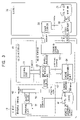
- FIG. 3 is a block diagram showing the construction of a system for realizing a map-data distribution method according to a second embodiment of the invention
- FIG. 4 is a flowchart illustrating the operation of a map-data retrieval unit according to the second embodiment of the invention.
- FIG. 5 consists of illustrations showing the data structure of road data
- FIG. 6 consists of illustrations showing the data structure of polygon data
- FIG. 7 consists of illustrations showing the data structure of character string data
- FIG. 9 is a flowchart illustrating an operation of a map-data retrieval unit according to a third embodiment of the invention.
- FIG. 1 shows the construction of a system for realizing a map-data distribution method according to the first embodiment of the invention.
- the system includes a map-data distribution server 10 and a client 20 which are connected via a communication line such as the Internet.
- the map-data distribution server 10 includes a map database 11 for storing map data therein and a CGI (Common Gateway Interface) 12 for extracting predetermined image data from the map database 11 .
- CGI Common Gateway Interface
- Map data stored in the map database 11 is divided into segments, each of which has an appropriate range of longitudes and an appropriate range of latitudes in accordance with a map scale such as 1:12500, 1:25000, 1:50000, or 1:100000.
- roads are represented by links among a plurality of nodes (vertexes) and are stored as a set of the nodes represented by the longitudes and the latitudes of the corresponding nodes.
- the map data includes the following data: (1) road data used for drawing road images and including the positions of nodes and the states of links; (2) polygon data used for drawing polygon images such as buildings, facilities, parks, rivers, and the like; (3) character string data for displaying the names of administrative districts such as the names of cities, the names of towns, and the like; (4) landmark data for displaying landmark building images, landmark shop images, and the like; and (5) altitude data used for displaying contour lines and the like.
- the client 20 includes a WWW browser 21 for accessing a web site on the server 10 , a map drawing program 22 for drawing a map image on a display unit while cooperating with the WWW browser 21 , and a cache (temporary storage memory) 23 for temporarily storing the map data transmitted from the server 10 .
- the map drawing program 22 is implemented, for example, as a Java applet, by Active X, or as a plug-in program.
- the cache 23 is realized using an unused region of a semiconductor memory (DRAM: Dynamic Random Access Memory) or an unused region of a hard disk drive.
- DRAM Dynamic Random Access Memory
- FIG. 2 shows the map-data distribution method according to the present embodiment of the invention.
- the client 20 accesses the web site providing the electronic map distribution service via a communication line such as the Internet using the WWW browser 21 .
- a user specifies a desired location by applying a predetermined operation.
- Various methods for specifying the desired location can be considered, such as a method in which the client 20 initially displays a wide-area map on the display and the user specifies the desired location from the wide-area map, or a method in which the user specifies the desired location by the place name such as the name of a state, a prefecture, a city, a town, a village, or a station.
- the user directly inputs the latitude and the longitude of the desired location.
- the client 20 transmits a map-data request and the input latitude and longitude to the server 10 .
- the user can specify the order of priority of the data to be transmitted from the server 10 .
- the user is assumed to specify the order of priority of the transmission data as follows: the road data, the character string data, the landmark data, the polygon data, etc.
- the order of priority of the transmission data is initialized and then the user can arbitrarily change it.
- the server 10 When the server 10 receives the map-data request from the client 20 , the server 10 starts the CGI 12 .
- the CGI 12 retrieves the map data including the desired location from the map database 11 .
- the server 10 transmits, to the client 20 , the map data retrieved by the CGI 12 in the specified order of priority.
- the client 20 does not wait for the entire map data to be transmitted from the server 10 before starting to draw the map image. What the client 20 actually does is to receive the map data while simultaneously drawing the map image based on the received map data. That is, the client 20 stores the data transmitted from the server 10 in the cache 23 while starting the map drawing program 22 and causing it to draw the map image based on the map data transmitted from the server 10 or the map data stored in the cache 23 .
- the server 10 since the server 10 transmits the data in the order of the road data, the character string data, the landmark data, the polygon data, etc., the client 20 initially receives the road data and then draws road images. When the character string data, the landmark data, and the like are received before the road drawing processing is completed, these data are stored in the cache 23 . When the cache 23 is out of memory, the program 22 discards data already used for drawing, data referenced less frequently, or data having lower priority from among the road data stored in the cache 23 .
- map image is shown on a screen of the client 20 .
- the client 20 since the client 20 starts to draw the map image right after the server 10 starts to transmit the road data, less time is required to draw the map image compared to a case in which all the map data is received and then the map image starts to be drawn. Furthermore, since, in the present embodiment, the road drawing processing, the character string drawing processing, and the landmark drawing processing are performed in this order, the desired location and its surroundings can be recognized to some extent before the entirety of the map image is drawn.
- the client 20 cancels the map data reception and requests that the server 10 transmit new map data.
- the client 20 transmits a signal which lets the server 10 know that there is no need to transmit this new map data to the client 20 . Accordingly, the server 10 can avoid transmitting duplicated data and transmits only necessary data.
- the present embodiment excludes, as much as possible, the time lag up to when the entirety of the map image is displayed by causing the server 10 to avoid transmitting unnecessary data.
- the present embodiment can reduce this time lag and can improve the usability of the system.
- the client 20 since data transfer is performed for the map component unit constituting a segment of the map data and not for the segment of the map component having a certain amount of image data, the client 20 can finely control the transferred data. Accordingly, the communication and the map drawing processing can be more efficiently performed.
- FIG. 3 shows the construction of a system for realizing a map-data distribution method according to the second embodiment of the invention.
- the system includes a map-data distribution server 30 and a client 40 .
- the map-data distribution server 30 includes a map database (DB) 31 for storing the map data therein, a CGI or a Servlet 32 (referred to as the CGI/Servlet 32 ) for extracting predetermined map data from the map database 31 , and a WWW server 33 .
- the map database 31 contains the map data which are classified by the map components such as the road data, the polygon data, the character string data, and the landmark data in accordance with the map scales.
- the WWW server 33 can be accessed from the Internet and provides the web site. Accordingly, the client 40 can easily access the map-data distribution server 30 using a web browser.
- the CGI/Servlet 32 is activated in accordance with a request from the client 40 which accesses the server 30 .
- the CGI/Servlet 32 retrieves, from the map database 31 , map data having the desired location and the desired map scale requested from the client 40 and transmits, to the client 40 , the map components of the retrieved map data in the requested order.
- the client 40 is a general-purpose computer, which for example, reads a specific program and executes the program.
- the client 40 includes a CPU (Central Processing Unit), a main memory (primary storage unit such as a DRAM), a video memory for drawing images, a secondary storage unit (such as a hard disk drive), an input unit (such as a keyboard or a mouse), a communication unit (such as a modem, a router, or a terminal adapter), and a display unit (such as a CRT (cathode ray tube) or an LCD (Liquid Crystal Display)).
- a CPU Central Processing Unit
- main memory primary storage unit such as a DRAM
- video memory for drawing images
- secondary storage unit such as a hard disk drive
- an input unit such as a keyboard or a mouse
- a communication unit such as a modem, a router, or a terminal adapter
- a display unit such as a CRT (cathode ray tube) or an LCD (Liqui
- the client 40 is not necessarily a general-purpose computer and it may be an electronic device (communication terminal) using computer technology such as a car navigation device or a PDA (Personal Digital Assistant).
- a car navigation device or a PDA (Personal Digital Assistant).
- PDA Personal Digital Assistant
- the client 40 includes three threads, namely, a user-interface thread 41 , a main thread 42 , and a drawing thread 43 .
- a user-interface thread 41 a main thread 41 , and a drawing thread 43 .
- the user interface thread 41 includes a control unit 51 .
- the main thread 42 includes a map-data retrieval unit 52 , a communication unit 53 , and a cache management unit 54 .
- the drawing thread 43 includes a drawing unit 55 and a drawing queue 56 .
- a cache 44 for temporarily storing the map data received from the server 30 is configured using a part of the primary storage unit or a part of the secondary storage unit. In the present embodiment, the cache 44 has a capacity to store nine screens of data. The map image currently displayed on the screen is stored in the middle of the cache 44 . Hence, the map image can be smoothly scrolled.
- the control unit 51 of the user interface thread 41 interprets the input from the keyboard, the mouse or the like and sends a request based on the interpreted input. For example, when the user moves a cursor to a predetermined position of the screen and inputs the latitude and longitude of a desired location, the control unit 51 sends, to the main thread 42 , a drawing request for a map image having the input latitude and longitude. Alternatively, for example, when the user clicks on a scroll button displayed on the screen, the control unit 51 sends a scroll request to the main thread 42 .
- a request sent from the user interface thread 41 may be referred to as a parameter.
- the parameter contains items such as (i) the latitude and longitude, (ii) the map scale, (iii) the type of a map component (the road data, the character string data, construction-polygon data (buildings, etc.), other-polygon data (parks, rivers, seas, etc.), the landmark data, and the like), and (iv) the order of priority of the map components (the drawing order).
- the control unit 51 sends this parameter to the main thread 42 .
- the order of priority of the map components are initialized, for example, as follows in descending order of priority: the road data, the construction-polygon data, the other-polygon data, the character string data, and the landmark data, the user can change the order of priority.
- the user interface thread 41 After sending the parameter to the main thread 42 , the user interface thread 41 waits for another input from the user.
- the communication unit 53 of the main thread 42 controls the communication device such as the modem, the router, and the terminal adapter so as to access the server 30 , and transmit, to the server 30 , the map-data request for each map component which is sent from the map-data retrieval unit 52 . Furthermore, the communication unit 53 receives map data for each map component, which is transmitted from the server 30 , and sends it to the map-data retrieval unit 52 .
- the cache management unit 54 manages the map components stored in the cache 44 .
- the cache management unit 54 has information about the map scale, the type of each map component, and the address of each map component in the cache 44 , thereby facilitating retrieval of the map data stored in the cache 44 .
- the cache management unit 54 adds a map component, transmitted from the server 30 , to the cache 44 and deletes a map component stored in the cache 44 .
- the map-data retrieval unit 52 receives the parameter from the user interface thread 41 , and performs map-data retrieval processing on the map components in descending order of priority in accordance with the flowchart shown in FIG. 4 .
- the process determines, using the cache management unit 54 , whether a map component is stored in the cache 44 . If the result of the determination is affirmative, the process proceeds from step S 12 to step S 16 , otherwise the process proceeds from step S 12 to step S 13 .
- the process requests the server 30 to transmit map data (the map component) via the communication unit 53 .
- the transmitted map component is received.
- the process causes the cache management unit 54 to store the received map component in the cache 44 .
- the cache 44 is out of memory, an empty region for storing this new map component therein is secured by deleting some map components stored therein.
- Various methods for determining which map component is to be deleted can be considered.
- the cache management unit 54 has information about the frequency of reference for each map component and secures an empty region by deleting a map component which is referenced less frequently, or a method in which the cache management unit 54 manages map components by linking a map component when the component is used, and secures an empty region by deleting a map component that does not link to the currently displayed map image.
- an empty region may be secured by deleting the map components of the map image to the left of the currently displayed one.
- step S 16 the process adds the drawing request for this map component to the drawing queue 56 .
- the drawing queue 56 stores the drawing request for each map component.
- the drawing request is one of the following commands and data addresses in accordance with the type of the map component:
- the drawing queue 56 can store commands as well as the corresponding data (the corresponding map component) therein. However, in the present embodiment, the commands and the addresses to the corresponding data are stored in the drawing queue 56 .
- the drawing unit 55 draws the map image in accordance with the drawing requests of the drawing queue 56 in the stored order.
- the drawing queue 56 is assumed to have drawing requests in the following order, namely, the road drawing requests, the construction-polygon drawing requests, the other-polygon drawing requests, the character string drawing requests, and the landmark drawing requests.
- the drawing unit 55 reads road data from the cache 44 and draws the road images on the map image by expanding the road data in the video memory.
- the drawing unit 55 reads construction-polygon data from the cache 44 and draws the building images and the like by expanding the polygon data in the video memory.
- the drawing unit 55 reads other-polygon data from the cache 44 and draws the images of the parks, the rivers, the seas, and the like by expanding the other-polygon data in the video memory. After that, the drawing unit 55 reads character string data from the cache 44 and draws the character strings. Finally, the drawing unit 55 reads landmark data from the cache 44 and draws the landmark images.
- the drawing request is discarded from the drawing queue 56 .
- the drawing unit 55 repeats the above-described processing until the drawing queue 56 becomes empty. Since the main thread 42 sorts the drawing requests in the drawing queue 56 so that the drawing requests are arranged in descending order of priority, the drawing thread 43 draws map components in descending order of priority.
- FIGS. 5 to 8 show the data structure of each map component (the road data, the polygon data, the character string data, and the landmark data).
- the map components are divided into segments having an appropriate range of latitudes and of longitudes.
- the bounds of the segment are defined using the absolute longitude and latitude coordinates (XT 1 , YT 1 ) and (XT 2 , YT 2 ) of diagonal vertices E and F.
- the road data is represented by a set of a plurality of nodes.
- the road data is divided into attribute data and coordinate data.
- the road data includes a type (line), a color, a line-type (a solid line or a dashed line, and its line width), and the number of nodes.
- the road data includes the relative coordinates of each of nodes G 1 , G 2 , G 3 , and so on.
- the construction-polygon data and the other-polygon data are also represented by a set of a plurality of nodes and are formed into a closed figure by connecting the end node (here, G 4 ) and the start node (G 1 ).
- the polygon data includes the type (polygon), the color of a line (contour), the line type (solid line or dashed line, and its line width), the number of nodes, and a filling color (the color inside the polygon).
- coordinate data the polygon data includes the relative coordinates of each node.
- the character string data includes, as attribute data, the type (character string), the color (the color of the character string), and the number of the characters of the character string.
- the character string data includes the start position (G 1 ) and the gradient of the character string.
- the character codes of the characters of the character string are stored after the coordinate data of the character string data.
- the landmark data includes the type (landmark) as attribute data.
- the landmark data includes the displayed position (G 1 ) of the landmark as coordinate data and further includes a unique landmark code for the landmark.
- the landmark image (bitmap) may be transmitted from the server 30 , or it may be provided in the client 40 beforehand.
- the drawing unit 55 obtains each map component and draws the map image using it.
- image data corresponding to nine screens of the display unit are expanded in the video memory, and the map image is shown on the display unit by clipping one screen of image data out of the expanded data.
- the displayed map image can be smoothly scrolled.
- the client 40 is an electronic device having a limited capacity of video memory, such as a PDA
- image data corresponding to only one screen of the display unit is expanded in the video memory.
- another screen of image data is expanded in the video memory.
- the user interface thread 41 , the main thread 42 , and the drawing thread 43 cooperate with one another, thereby performing user input processing, map-data retrieval processing, and map-image drawing processing in parallel.
- the map components such as the road data, the construction-polygon data, the other-polygon data, the character string data, and the landmark data are drawn in the requested order of priority and are shown on the display unit. Accordingly, the time between user input and display of the map image can be minimized, and usability of the system can be improved.
- the third embodiment according to the present invention will now be described.
- the characteristic feature of the third embodiment is an operation of the map-data retrieval unit 52 , and otherwise the basic construction of the present embodiment is identical to that of the second embodiment.
- the present embodiment is also described with reference to FIG. 3 , and repeated descriptions are omitted.
- the drawing unit 55 performs map-image drawing processing in accordance with the map components read from the cache 44 until the drawing queue 56 is empty.
- the map-data retrieval unit 52 of the present embodiment performs processing in accordance with the flowchart shown in FIG. 9 .
- the process receives a map-data request or a map scale change request from the user interface thread 41 when the user inputs a new desired location or a new desired map scale.
- the process discards the unprocessed drawing requests stored in the drawing queue 56 . Since the drawing queue 56 becomes empty, the drawing unit 55 is suspended until a new drawing request is added to the drawing queue 56 .
- the map-data retrieval unit 52 performs the processing shown in FIG. 4 for each map component in descending order of priority.
- the unprocessed drawing requests stored in the drawing queue 56 are discarded and then the new drawing request is added to the drawing queue 56 . That is, when the change of the map scale or the map having the newly desired location is requested before every map component of the map image currently being drawn is drawn, currently running map-image processing is cancelled and a map having the newly desired location starts to be drawn. Therefore, the present embodiment enables response characteristics to be improved compared to the response characteristics obtained using the second embodiment.
- the map data (the map components) are stored in the cache 23 or 44 (the temporary storage memory). Since the map data stored in the cache are discarded soon, when it is desired to re-use the map data after it has been discarded, the server must re-transmit the map data. To avoid the re-transmission, the map data may be stored not only in the cache but also in a nonvolatile storage device such as a hard disk drive.
Abstract
Description
-
- (i) A command for drawing road images displayed on the screen and the data address of the road data stored in the
cache 44. - (ii) A command for drawing character-strings displayed on the screen and the data address of the character string data stored in the
cache 44. - (iii) A command for drawing construction-polygon images displayed on the screen and the data address of the construction-polygon data stored in the
cache 44. - (iv) A command for drawing other-polygon images displayed on the screen and the data address of the other-polygon data stored in the
cache 44. - (v) A command for drawing landmark images displayed on the screen and the data address of the landmark data stored in the
cache 44.
- (i) A command for drawing road images displayed on the screen and the data address of the road data stored in the
Claims (18)
Applications Claiming Priority (1)
| Application Number | Priority Date | Filing Date | Title |
|---|---|---|---|
| JP2000170290A JP4097881B2 (en) | 1999-08-25 | 2000-06-07 | Map data distribution method |
Publications (1)
| Publication Number | Publication Date |
|---|---|
| US7010567B1 true US7010567B1 (en) | 2006-03-07 |
Family
ID=35966381
Family Applications (1)
| Application Number | Title | Priority Date | Filing Date |
|---|---|---|---|
| US09/642,739 Expired - Lifetime US7010567B1 (en) | 2000-06-07 | 2000-08-18 | Map-data distribution method, and map-data distribution server and client |
Country Status (1)
| Country | Link |
|---|---|
| US (1) | US7010567B1 (en) |
Cited By (16)
| Publication number | Priority date | Publication date | Assignee | Title |
|---|---|---|---|---|
| US20040215387A1 (en) * | 2002-02-14 | 2004-10-28 | Matsushita Electric Industrial Co., Ltd. | Method for transmitting location information on a digital map, apparatus for implementing the method, and traffic information provision/reception system |
| US20040267961A1 (en) * | 2003-06-26 | 2004-12-30 | International Business Machines Corporation | In a World Wide Web communications network simplifying the Uniform Resource Locators (URLS) displayed in association with received web documents |
| US20050162435A1 (en) * | 2004-01-22 | 2005-07-28 | Electronic Arts Inc. | Image rendering with multi-level Z-buffers |
| US20070021911A1 (en) * | 2003-10-09 | 2007-01-25 | Shin Kikuchi | Map displaying device, map display method, and map display program |
| US20070061748A1 (en) * | 2005-09-14 | 2007-03-15 | Sony Corporation | Electronic apparatus, display control method for the electronic apparatus, graphical user interface, and display control program |
| US7206804B1 (en) * | 2000-11-10 | 2007-04-17 | Sharp Laboratories Of America, Inc. | Methods and systems for transmitting digital images |
| US20090319188A1 (en) * | 2006-07-21 | 2009-12-24 | Teleatlas N.V. | Method for generating a location reference and method for mapping information to a position within a digital map database |
| US20100146819A1 (en) * | 2008-12-16 | 2010-06-17 | Skechers U.S.A., Inc. Ll | Shoe |
| US20100275471A1 (en) * | 2008-12-16 | 2010-11-04 | Skechers U.S.A., Inc. Ii | Shoe |
| USRE42977E1 (en) * | 2000-09-07 | 2011-11-29 | Gula Consulting Limited Liability Company | Method for segmenting a video image into elementary objects |
| USRE43923E1 (en) | 2000-09-22 | 2013-01-15 | Tierravision, Inc. | Method for organizing and compressing spatial data |
| US8447512B2 (en) | 2001-07-31 | 2013-05-21 | Roger Maria Stenbock | Process for generating computer flight plans on the Internet |
| US8649968B2 (en) | 2004-09-07 | 2014-02-11 | Tierravision, Inc. | System and method of wireless downloads of map and geographic based data to portable computing devices |
| US8972187B1 (en) * | 2013-06-28 | 2015-03-03 | Google Inc. | Varying the degree of precision in navigation data analysis |
| US9204261B2 (en) | 2010-04-19 | 2015-12-01 | Toyota Jidosha Kabushiki Kaisha | Vehicular control apparatus |
| US9665924B2 (en) * | 2015-04-01 | 2017-05-30 | Microsoft Technology Licensing, Llc | Prioritized requesting of mapping layers |
Citations (5)
| Publication number | Priority date | Publication date | Assignee | Title |
|---|---|---|---|---|
| US5682525A (en) | 1995-01-11 | 1997-10-28 | Civix Corporation | System and methods for remotely accessing a selected group of items of interest from a database |
| US5848373A (en) * | 1994-06-24 | 1998-12-08 | Delorme Publishing Company | Computer aided map location system |
| US6311221B1 (en) * | 1998-07-22 | 2001-10-30 | Appstream Inc. | Streaming modules |
| US6577714B1 (en) * | 1996-03-11 | 2003-06-10 | At&T Corp. | Map-based directory system |
| US6757717B1 (en) * | 1999-09-16 | 2004-06-29 | Proxyconn, Inc. | System and method for data access |
-
2000
- 2000-08-18 US US09/642,739 patent/US7010567B1/en not_active Expired - Lifetime
Patent Citations (5)
| Publication number | Priority date | Publication date | Assignee | Title |
|---|---|---|---|---|
| US5848373A (en) * | 1994-06-24 | 1998-12-08 | Delorme Publishing Company | Computer aided map location system |
| US5682525A (en) | 1995-01-11 | 1997-10-28 | Civix Corporation | System and methods for remotely accessing a selected group of items of interest from a database |
| US6577714B1 (en) * | 1996-03-11 | 2003-06-10 | At&T Corp. | Map-based directory system |
| US6311221B1 (en) * | 1998-07-22 | 2001-10-30 | Appstream Inc. | Streaming modules |
| US6757717B1 (en) * | 1999-09-16 | 2004-06-29 | Proxyconn, Inc. | System and method for data access |
Cited By (30)
| Publication number | Priority date | Publication date | Assignee | Title |
|---|---|---|---|---|
| US20080201073A1 (en) * | 1999-07-28 | 2008-08-21 | Matsushita Electric Industrial Co., Ltd. | Method for transmitting location information on a digital map, apparatus for implementing the method and traffic information provision/reception system |
| US8838386B2 (en) | 1999-07-28 | 2014-09-16 | Panasonic Intellectual Property Corporation Of America | Method for transmitting location information on a digital map, apparatus for implementing the method, and traffic information provision/reception system |
| US8219314B2 (en) | 1999-07-28 | 2012-07-10 | Panasonic Corporation | Method for transmitting location information on a digital map, apparatus for implementing the method and traffic information provision/reception system |
| US20100106410A1 (en) * | 1999-07-28 | 2010-04-29 | Panasonic Corporation | Method for transmitting location information on a digital map, apparatus for implementing the method, and traffic information provision/reception system |
| USRE42977E1 (en) * | 2000-09-07 | 2011-11-29 | Gula Consulting Limited Liability Company | Method for segmenting a video image into elementary objects |
| USRE43923E1 (en) | 2000-09-22 | 2013-01-15 | Tierravision, Inc. | Method for organizing and compressing spatial data |
| US7206804B1 (en) * | 2000-11-10 | 2007-04-17 | Sharp Laboratories Of America, Inc. | Methods and systems for transmitting digital images |
| US8793070B2 (en) | 2001-07-31 | 2014-07-29 | Roger M. Stenbock | Process for generating computer flight plans on the internet |
| US8447512B2 (en) | 2001-07-31 | 2013-05-21 | Roger Maria Stenbock | Process for generating computer flight plans on the Internet |
| US20040215387A1 (en) * | 2002-02-14 | 2004-10-28 | Matsushita Electric Industrial Co., Ltd. | Method for transmitting location information on a digital map, apparatus for implementing the method, and traffic information provision/reception system |
| US20040267961A1 (en) * | 2003-06-26 | 2004-12-30 | International Business Machines Corporation | In a World Wide Web communications network simplifying the Uniform Resource Locators (URLS) displayed in association with received web documents |
| US7970936B2 (en) * | 2003-06-26 | 2011-06-28 | International Business Machines Corporation | In a world wide web communications network simplifying the uniform resource locators (URLS) displayed in association with received web documents |
| US20070021911A1 (en) * | 2003-10-09 | 2007-01-25 | Shin Kikuchi | Map displaying device, map display method, and map display program |
| US7647168B2 (en) * | 2003-10-09 | 2010-01-12 | Navitime Japan Co., Ltd. | Map displaying apparatus, map displaying method, and computer product |
| US20050162435A1 (en) * | 2004-01-22 | 2005-07-28 | Electronic Arts Inc. | Image rendering with multi-level Z-buffers |
| US10244361B1 (en) | 2004-09-07 | 2019-03-26 | Tierravision, Inc. | System and method of wireless downloads of map and geographic based data to portable computing devices |
| US8649968B2 (en) | 2004-09-07 | 2014-02-11 | Tierravision, Inc. | System and method of wireless downloads of map and geographic based data to portable computing devices |
| US9137633B2 (en) | 2004-09-07 | 2015-09-15 | Tierravision, Inc. | System and method of wireless downloads of map and geographic based data to portable computing devices |
| US20070061748A1 (en) * | 2005-09-14 | 2007-03-15 | Sony Corporation | Electronic apparatus, display control method for the electronic apparatus, graphical user interface, and display control program |
| US8065633B2 (en) * | 2005-09-14 | 2011-11-22 | Sony Corporation | Electronic apparatus, display control method for the electronic apparatus, graphical user interface, and display control program |
| US9152294B2 (en) | 2005-09-14 | 2015-10-06 | Sony Corporation | Electronic apparatus, display control method for the electronic apparatus, graphical user interface, and display control program |
| US20090319188A1 (en) * | 2006-07-21 | 2009-12-24 | Teleatlas N.V. | Method for generating a location reference and method for mapping information to a position within a digital map database |
| US20100275471A1 (en) * | 2008-12-16 | 2010-11-04 | Skechers U.S.A., Inc. Ii | Shoe |
| US20100146819A1 (en) * | 2008-12-16 | 2010-06-17 | Skechers U.S.A., Inc. Ll | Shoe |
| US9204261B2 (en) | 2010-04-19 | 2015-12-01 | Toyota Jidosha Kabushiki Kaisha | Vehicular control apparatus |
| US8972187B1 (en) * | 2013-06-28 | 2015-03-03 | Google Inc. | Varying the degree of precision in navigation data analysis |
| US9665924B2 (en) * | 2015-04-01 | 2017-05-30 | Microsoft Technology Licensing, Llc | Prioritized requesting of mapping layers |
| CN107430627A (en) * | 2015-04-01 | 2017-12-01 | 微软技术许可有限责任公司 | The priority ranking request of map layer |
| CN107430627B (en) * | 2015-04-01 | 2020-12-11 | 微软技术许可有限责任公司 | Map layer prioritization requests |
| EP3281124B1 (en) * | 2015-04-01 | 2021-10-06 | Microsoft Technology Licensing LLC | Prioritized requesting of mapping layers |
Similar Documents
| Publication | Publication Date | Title |
|---|---|---|
| US7010567B1 (en) | Map-data distribution method, and map-data distribution server and client | |
| JP3000972B2 (en) | Information providing apparatus and machine-readable recording medium recording program | |
| JP3503397B2 (en) | Map display system | |
| US7260474B1 (en) | GIS point-to-point routing for directions | |
| US20040217980A1 (en) | Image streaming | |
| JP4097881B2 (en) | Map data distribution method | |
| EP1426876A1 (en) | Geographical information system | |
| US20070233384A1 (en) | Method and system for off-board navigation with a portable device | |
| US20020030844A1 (en) | Portable high speed internet access device | |
| US20030011631A1 (en) | System and method for document division | |
| JP2003308211A (en) | Mobile terminal, and server and system for service distribution | |
| US7289244B2 (en) | Portable high speed internet access device | |
| JP3660287B2 (en) | Map data distribution device, map data reception device, map data distribution method, and map data reception method | |
| JPH11232433A (en) | Map display control system | |
| JP5294522B2 (en) | Map / photo image distribution system and its client system | |
| JP4874205B2 (en) | Map display method and map display device | |
| JP3691405B2 (en) | Data management apparatus and map display system | |
| KR20010100609A (en) | Service method for map information of Geographic Information System | |
| JP2004029115A (en) | Map attribute information updating system, server system, terminal device, map attribute information updating method, map attribute information updating program, and recording medium having map attribute information updating program recorded therein | |
| JP2002123456A (en) | Method and device for processing image and storage medium | |
| JP2003208597A (en) | Image converter and image conversion method | |
| JP2002202935A (en) | Server device | |
| JP2002091983A (en) | Device, method and system for adding map information | |
| JP3476805B2 (en) | Image display system and method | |
| KR20030037453A (en) | The dynamic sketch map generation methods for mobile map service |
Legal Events
| Date | Code | Title | Description |
|---|---|---|---|
| AS | Assignment |
Owner name: ALPINE ELECTRONIC, INC., JAPAN Free format text: ASSIGNMENT OF ASSIGNORS INTEREST;ASSIGNOR:MORI, DAISHI;REEL/FRAME:011337/0923 Effective date: 20001109 |
|
| STCF | Information on status: patent grant |
Free format text: PATENTED CASE |
|
| FEPP | Fee payment procedure |
Free format text: PAYER NUMBER DE-ASSIGNED (ORIGINAL EVENT CODE: RMPN); ENTITY STATUS OF PATENT OWNER: LARGE ENTITY Free format text: PAYOR NUMBER ASSIGNED (ORIGINAL EVENT CODE: ASPN); ENTITY STATUS OF PATENT OWNER: LARGE ENTITY |
|
| FPAY | Fee payment |
Year of fee payment: 4 |
|
| FPAY | Fee payment |
Year of fee payment: 8 |
|
| MAFP | Maintenance fee payment |
Free format text: PAYMENT OF MAINTENANCE FEE, 12TH YEAR, LARGE ENTITY (ORIGINAL EVENT CODE: M1553) Year of fee payment: 12 |