EP1599702B1 - Navigation device and method for exchanging data between resident applications - Google Patents
Navigation device and method for exchanging data between resident applications Download PDFInfo
- Publication number
- EP1599702B1 EP1599702B1 EP04714855A EP04714855A EP1599702B1 EP 1599702 B1 EP1599702 B1 EP 1599702B1 EP 04714855 A EP04714855 A EP 04714855A EP 04714855 A EP04714855 A EP 04714855A EP 1599702 B1 EP1599702 B1 EP 1599702B1
- Authority
- EP
- European Patent Office
- Prior art keywords
- address
- navigation
- multiple applications
- navigation software
- application
- Prior art date
- Legal status (The legal status is an assumption and is not a legal conclusion. Google has not performed a legal analysis and makes no representation as to the accuracy of the status listed.)
- Expired - Lifetime
Links
- 238000000034 method Methods 0.000 title claims description 11
- 238000012546 transfer Methods 0.000 claims description 4
- 238000012545 processing Methods 0.000 claims description 3
- 241001272996 Polyphylla fullo Species 0.000 claims description 2
- 238000006243 chemical reaction Methods 0.000 claims description 2
- 238000004364 calculation method Methods 0.000 abstract description 3
- 230000006870 function Effects 0.000 description 7
- 239000013598 vector Substances 0.000 description 6
- 238000004422 calculation algorithm Methods 0.000 description 5
- 238000013461 design Methods 0.000 description 3
- 230000000694 effects Effects 0.000 description 3
- 230000010354 integration Effects 0.000 description 3
- 230000036651 mood Effects 0.000 description 2
- 238000007514 turning Methods 0.000 description 2
- 101150064138 MAP1 gene Proteins 0.000 description 1
- 230000003796 beauty Effects 0.000 description 1
- 238000005516 engineering process Methods 0.000 description 1
- 230000003993 interaction Effects 0.000 description 1
- 230000003278 mimic effect Effects 0.000 description 1
- 238000010295 mobile communication Methods 0.000 description 1
Images


Classifications
-
- G—PHYSICS
- G06—COMPUTING; CALCULATING OR COUNTING
- G06F—ELECTRIC DIGITAL DATA PROCESSING
- G06F3/00—Input arrangements for transferring data to be processed into a form capable of being handled by the computer; Output arrangements for transferring data from processing unit to output unit, e.g. interface arrangements
- G06F3/01—Input arrangements or combined input and output arrangements for interaction between user and computer
- G06F3/048—Interaction techniques based on graphical user interfaces [GUI]
- G06F3/0487—Interaction techniques based on graphical user interfaces [GUI] using specific features provided by the input device, e.g. functions controlled by the rotation of a mouse with dual sensing arrangements, or of the nature of the input device, e.g. tap gestures based on pressure sensed by a digitiser
- G06F3/0488—Interaction techniques based on graphical user interfaces [GUI] using specific features provided by the input device, e.g. functions controlled by the rotation of a mouse with dual sensing arrangements, or of the nature of the input device, e.g. tap gestures based on pressure sensed by a digitiser using a touch-screen or digitiser, e.g. input of commands through traced gestures
- G06F3/04886—Interaction techniques based on graphical user interfaces [GUI] using specific features provided by the input device, e.g. functions controlled by the rotation of a mouse with dual sensing arrangements, or of the nature of the input device, e.g. tap gestures based on pressure sensed by a digitiser using a touch-screen or digitiser, e.g. input of commands through traced gestures by partitioning the display area of the touch-screen or the surface of the digitising tablet into independently controllable areas, e.g. virtual keyboards or menus
-
- G—PHYSICS
- G01—MEASURING; TESTING
- G01C—MEASURING DISTANCES, LEVELS OR BEARINGS; SURVEYING; NAVIGATION; GYROSCOPIC INSTRUMENTS; PHOTOGRAMMETRY OR VIDEOGRAMMETRY
- G01C21/00—Navigation; Navigational instruments not provided for in groups G01C1/00 - G01C19/00
- G01C21/26—Navigation; Navigational instruments not provided for in groups G01C1/00 - G01C19/00 specially adapted for navigation in a road network
- G01C21/34—Route searching; Route guidance
- G01C21/36—Input/output arrangements for on-board computers
- G01C21/3605—Destination input or retrieval
- G01C21/362—Destination input or retrieval received from an external device or application, e.g. PDA, mobile phone or calendar application
-
- G—PHYSICS
- G06—COMPUTING; CALCULATING OR COUNTING
- G06F—ELECTRIC DIGITAL DATA PROCESSING
- G06F1/00—Details not covered by groups G06F3/00 - G06F13/00 and G06F21/00
- G06F1/16—Constructional details or arrangements
- G06F1/1613—Constructional details or arrangements for portable computers
- G06F1/1626—Constructional details or arrangements for portable computers with a single-body enclosure integrating a flat display, e.g. Personal Digital Assistants [PDAs]
-
- G—PHYSICS
- G06—COMPUTING; CALCULATING OR COUNTING
- G06F—ELECTRIC DIGITAL DATA PROCESSING
- G06F3/00—Input arrangements for transferring data to be processed into a form capable of being handled by the computer; Output arrangements for transferring data from processing unit to output unit, e.g. interface arrangements
- G06F3/01—Input arrangements or combined input and output arrangements for interaction between user and computer
- G06F3/048—Interaction techniques based on graphical user interfaces [GUI]
- G06F3/0481—Interaction techniques based on graphical user interfaces [GUI] based on specific properties of the displayed interaction object or a metaphor-based environment, e.g. interaction with desktop elements like windows or icons, or assisted by a cursor's changing behaviour or appearance
- G06F3/04817—Interaction techniques based on graphical user interfaces [GUI] based on specific properties of the displayed interaction object or a metaphor-based environment, e.g. interaction with desktop elements like windows or icons, or assisted by a cursor's changing behaviour or appearance using icons
-
- G—PHYSICS
- G06—COMPUTING; CALCULATING OR COUNTING
- G06F—ELECTRIC DIGITAL DATA PROCESSING
- G06F3/00—Input arrangements for transferring data to be processed into a form capable of being handled by the computer; Output arrangements for transferring data from processing unit to output unit, e.g. interface arrangements
- G06F3/01—Input arrangements or combined input and output arrangements for interaction between user and computer
- G06F3/048—Interaction techniques based on graphical user interfaces [GUI]
- G06F3/0481—Interaction techniques based on graphical user interfaces [GUI] based on specific properties of the displayed interaction object or a metaphor-based environment, e.g. interaction with desktop elements like windows or icons, or assisted by a cursor's changing behaviour or appearance
- G06F3/0482—Interaction with lists of selectable items, e.g. menus
-
- G—PHYSICS
- G06—COMPUTING; CALCULATING OR COUNTING
- G06Q—INFORMATION AND COMMUNICATION TECHNOLOGY [ICT] SPECIALLY ADAPTED FOR ADMINISTRATIVE, COMMERCIAL, FINANCIAL, MANAGERIAL OR SUPERVISORY PURPOSES; SYSTEMS OR METHODS SPECIALLY ADAPTED FOR ADMINISTRATIVE, COMMERCIAL, FINANCIAL, MANAGERIAL OR SUPERVISORY PURPOSES, NOT OTHERWISE PROVIDED FOR
- G06Q10/00—Administration; Management
- G06Q10/02—Reservations, e.g. for tickets, services or events
-
- G—PHYSICS
- G08—SIGNALLING
- G08G—TRAFFIC CONTROL SYSTEMS
- G08G1/00—Traffic control systems for road vehicles
- G08G1/09—Arrangements for giving variable traffic instructions
- G08G1/0962—Arrangements for giving variable traffic instructions having an indicator mounted inside the vehicle, e.g. giving voice messages
- G08G1/0968—Systems involving transmission of navigation instructions to the vehicle
- G08G1/0969—Systems involving transmission of navigation instructions to the vehicle having a display in the form of a map
-
- G—PHYSICS
- G08—SIGNALLING
- G08G—TRAFFIC CONTROL SYSTEMS
- G08G1/00—Traffic control systems for road vehicles
- G08G1/123—Traffic control systems for road vehicles indicating the position of vehicles, e.g. scheduled vehicles; Managing passenger vehicles circulating according to a fixed timetable, e.g. buses, trains, trams
- G08G1/133—Traffic control systems for road vehicles indicating the position of vehicles, e.g. scheduled vehicles; Managing passenger vehicles circulating according to a fixed timetable, e.g. buses, trains, trams within the vehicle ; Indicators inside the vehicles or at stops
- G08G1/137—Traffic control systems for road vehicles indicating the position of vehicles, e.g. scheduled vehicles; Managing passenger vehicles circulating according to a fixed timetable, e.g. buses, trains, trams within the vehicle ; Indicators inside the vehicles or at stops the indicator being in the form of a map
Definitions
- This invention relates to a navigation device, such as GPS based receiver, that can display simulated navigation data and a related method.
- the device find particular application as an in-car navigation system. Data can be exchanged between applications resident on the device.
- GPS based devices are well known and are widely employed as in-car navigation systems. Reference may be made to the Navigator series software from the present assignee, TomTom B.V.
- This is software that, when running on a PDA (such as a Compaq iPaq) connected to an external GPS receiver, enables a user to input to the PDA a start and destination address. The software then calculates the best route between the two end-points and displays instructions on how to navigate that route.
- the software can determine at regular intervals the position of the PDA (typically mounted on the dashboard of a vehicle) and can display the current position of the vehicle on a map and display (and speak) appropriate navigation instructions (e.g.
- 'turn left in 100 m' Graphics depicting the actions to be accomplished (e.g. a left arrow indicating a left turn ahead) can be displayed in a status bar and also be superimposed over the applicable junctions/turnings etc in the roads shown in the map itself.
- 'navigation device' refers to a device that enables a user to navigate to a pre-defined destination.
- the device may have an internal system for receiving location data, such as a GPS receiver, or may merely be connectable to a receiver that can receive location data.
- a mobile wireless device with a GPS receiver able to obtain longitude and latitude information, sends that information to a remote web server over a wireless network for reverse geocoding - i.e. determining the street address from the latitude and longitude. That street address is then sent back to the wireless device over the wireless network to enable the device to display its location in street/city format.
- a navigation device programmed with a map database and navigation software that enables a route to be planned, wherein the navigation software presents an interface that is used by multiple applications resident on the device to allow the transfer of street city or postcode format address data used by each of the multiple applications to and/or from the navigation software and wherein the device is further programmed to be able to display a menu option that, if selected, causes the automatic export of street, city format or postcode format address data from one or more of the multiple applications resident on the device to the navigation software resident on the device for processing.
- selection of the menu option may initiate the conversion of the address data to a co-ordinate system based address by the navigation software, which can then Automatically be set as the destination address used by the navigation software in calculating the route and/or automatically marked on a map generated and displayed by the navigation software.
- co-ordinate system based address may be automatically returned to the application (or a different application resident on the device) and stored as part of the data held by or accessible by that application.
- the present invention is implemented in software from TomTom B.V. called Navigator. Navigator software runs on a touch screen (i.e. stylus controlled) Pocket PC powered PDA device, such as the Compaq iPaq. It provides a GPS based navigation system when the PDA is coupled with a GPS receiver.
- the combined PDA and GPS receiver system is designed to be used as an in-vehicle navigation system.
- the invention may also be implemented in any other arrangement of navigation device, such as one with an integral GPS receiver/computer/display, or a device designed for non-vehicle use (e.g. for walkers) or vehicles other than cars (e.g. aircraft).
- the navigation device may implement any kind of position sensing technology and is not limited to GPS; it can hence be implemented using other kinds of GNSS (global navigation satellite system) such as the European Galileo system. Equally, it is not limited to satellite based location/velocity systems but can equally be deployed using ground-based beacons or any other kind of system that enables the device to determine its geographic location.
- GNSS global navigation satellite system
- GNSS global navigation satellite system
- Navigator software when running on a PDA, results in a navigation device that causes the normal navigation mode screen shown in Figure 1 to be displayed.
- This view provides driving instructions using a combination of text, symbols, voice guidance and a moving map.
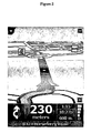
- Key user interface elements are the following: a 2-D map 1 occupies most of the screen. The map shows the user's car and its immediate surroundings, rotated in such a way that the direction in which the car is moving is always "up". Running across the bottom quarter of the screen is the status bar 2.
- the current location of the device, as the device itself determines using conventional GPS location finding and its orientation (as inferred from its direction of travel) is depicted by an arrow 3.
- the route calculated by the device (using route calculation algorithms stored in device memory as applied to map data stored in a map database in device memory) is shown as darkened path 4 superimposed with arrows giving the travel direction. On the darkened path 4, all major actions (e.g. turning corners, crossroads, roundabouts etc.) are schematically depicted by arrows 5 overlaying the path 4.
- the status bar 2 also includes at its left hand side a schematic 6 depicting the next action (here, a right turn).
- the status bar 2 also shows the distance to the next action (i.e, the right turn - here the distance is 220 meters) as extracted from a database of the entire route calculated by the device (i.e. a list of all roads and related actions defining the route to be taken).
- Status bar 2 also shows the name of the current road 8, the estimated time before arrival 9 (here 2 minutes and 40 seconds), the actual estimated arrival time 10 (11.36am) and the distance to the destination 11 (1.4Km).
- the GPS signal strength is shown in a mobile-phone style signal strength indicator 12.
- a navigation screen menu is displayed; from this menu, other core navigation functions within the Navigator application can be initiated or controlled. Allowing core navigation functions to be selected from a menu screen that is itself very readily called up (e.g. one step away from the map display to the menu screen) greatly simplifies the user interaction and makes it faster and easier.
- the area of the touch zone which needs to be touched by a user is far larger than in most stylus based touch screen systems. It is designed to be large enough to be reliably selected by a single finger without special accuracy; i.e. to mimic the real-life conditions for a driver when controlling a vehicle; he or she will have little time to look at a highly detailed screen with small control icons, and still less time to accurately press one of those small control icons.
- using a very large touch screen area associated with a given soft key (or hidden soft key, as in the centre of the screen 13) is a deliberate design feature of this implementation. Unlike other stylus based applications, this design feature is consistently deployed throughout Navigator to select core functions that are likely to be needed by a driver whilst actually driving.
- the device displays a map. Touching the map (i.e.
- the touch sensitive display once (or twice in a different implementation) near to the screen centre (or any part of the screen in another implementation) will then call up a navigation menu (see Figure 3 ) with large icons corresponding to various navigation functions, such as the option to calculate an alternative route, and re-calculate the route so as to avoid the next section of road (useful when faced with an obstruction or heavy congestion); or recalculate the route so as to avoid specific, listed roads.
- a navigation menu see Figure 3
- large icons corresponding to various navigation functions, such as the option to calculate an alternative route, and re-calculate the route so as to avoid the next section of road (useful when faced with an obstruction or heavy congestion); or recalculate the route so as to avoid specific, listed roads.
- memory stores the route calculation algorithms, map database and user interface software; a microprocessor interprets and processes user input (e.g. using a device touch screen to input the start and destination addresses and all other control inputs) and deploys the route calculation algorithms to calculate the optimal route.
- a microprocessor interprets and processes user input (e.g. using a device touch screen to input the start and destination addresses and all other control inputs) and deploys the route calculation algorithms to calculate the optimal route.
- 'Optimal' may refer to criteria such as shortest time or shortest distance, or some other user-related factors.
- the user inputs his start position and required destination in the normal manner into the Navigator software running on the PDA using a virtual keyboard.
- the user selects the manner in which a travel route is calculated: various modes are offered, such as a 'fast' mode that calculates the route very rapidly, but the route might not be the shortest; a 'full' mode that looks at all possible routes and locates the shortest, but takes longer to calculate etc.
- Other options are possible, with a user defining a route that is scenic - e.g. passes the most POI (points of interest) marked as views of outstanding beauty, or passes the most POIs of possible interest to children or uses the fewest junctions etc.
- Roads themselves are described in the map database that is part of Navigator (or is otherwise accessed by it) running on the PDA as lines - i.e. vectors (e.g. start point, end point, direction for a road, with an entire road being made up of many hundreds of such sections, each uniquely defined by start point/end point direction parameters).
- a map is then a set of such road vectors, plus points of interest (POIs), plus road names, plus other geographic features like park boundaries, river boundaries etc, all of which are defined in terms of vectors. All map features (e.g. road vectors, POIs etc.) are defined in a co-ordinate system that corresponds or relates to the GPS co-ordinate system, enabling a device's position as determined through a GPS system to be located onto the relevant road shown in a map.
- Route calculation uses complex algorithms that are part of the Navigator software.
- the algorithms are applied to score large numbers of potential different routes.
- the Navigator software then evaluates them against the user defined criteria (or device defaults), such as a full mode scan, with scenic route, past museums, and no speed camera.
- the route which best meets the defined criteria is then calculated by a processor in the PDA and then stored in a database in RAM as a sequence of vectors, road names and actions to be done at vector end-points (e.g. corresponding to pre-determined distances along each road of the route, such as after 100 meters, turn left into street x).
- Navigator presents an open interface to other applications resident on the device. Hence, those other applications can readily send data to Navigator software for Navigator to process and receive data from Navigator. This enables various new and powerful techniques, some of which are described below.
- the Navigator software is programmed with the WGC84 (or other co-ord system) co-ordinates of roads and house numbers along a road.
- WGC84 or other co-ord system
- the software determines the associated WGC84 co-ordinates (this process is called 'geocoding'); it can then also mark the start and destination positions on the maps it can display with appropriate icons. Navigator can share this geocoding capability with other applications (e.g. make it seamlessly and automatically available from within those applications).
- an option 'show on map' may hence be selected for a given contact address from within the contacts application. If selected, then the contact address, in street, city or postcode format, is exported to the Navigator software, which then geocodes it and displays on a map it generates a suitable icon at the appropriate location. This icon can be annotated with suitable information (e.g. contact name and address; possibly a thumbnail photo image of the contact).
- Navigator software also enables WGC 84 (or other co-ordinate) system data to be added automatically to a street/city etc. address in a contacts application or other application by using the co-ordinate system knowledge of the integrated Navigator navigation program.
- the user can, from within the contacts application, select a 'geocode address' function to be performed in relation to a specific address (or a bulk group of addresses).
- the contacts application hence exports the contact address from the database used by it (in house number, street, city format or postcode format) to the engine in the Navigator software that converts addresses expressed in these formats to WGC84 co-ordinates.
- This engine determines the WGC84 co-ordinates and returns that WGC84 data to a new field in the database used by the contacts application - the new field stores and makes available the WGC84 data within the contacts application (or indeed other applications, not only running on the device but also resident on remote devices).
- Being able to automatically add a geo-coded location e.g. the WGC 84 format location
- a geo-coded location e.g. the WGC 84 format location
- vCard format often include an address in street, city format
- a vCard received via e-mail or short range wireless etc. by the device can be processed by the device extracting the street address and sending that for geo-coding by the resident Navigator application; the geo-coded data can then be returned to the contacts database storing the vCard data to augment that data.
- This can facilitate many kinds of location based services that rely on geo-coded data; for example, imagine that the vCard recipient is a sales person and the vCard is from a customer; after the vCard address has been geo-coded, the device will have (and can download to a server) a geo-coded database of all customer contacts. Then, it will be far simpler to implement future activities that rely on accurate knowledge of customer locations, such as making service calls or delivering goods, since this will often be done using software that requires geo-coded data.
- Presence data will become a pervasive characteristic of personal mobile communications; a mobile telephone user's presence data defines the status of that user across many parameters (e.g. whether contactable by voice, data, SMS etc; current activity; current mood; physical or logical (e.g. work; home) location etc.). Presence data may be widely accessible to third parties; this enables in theory someone to determine the location of a friend etc. whose presence derived location data they have access to and can see (typically in a messaging application).
- Navigator software functionality can be integrated with a browser running on the device as follows: when the device displays a web page (or other kind of mark up language page) that includes an address in street, city or in postcode format, a user can readily take that address and send it to the Navigator software for it to display a map showing the actual location. This can be done with a browser plug-in that allows a user to select the address in the web page (e.g. highlight it); a drop down menu can then be selected. This menu includes the options 'Show location in Navigator' and Drive to this location'. Selecting the 'Show location in Navigator' option causes the automatic export of the address to Navigator, which then geocodes it and displays a map indicating the actual location. Selecting the Drive to this location' option causes the automatic export of the address to Navigator, which then geocodes it and uses the geocoded address as the destination address to calculate a route.
- a browser plug-in that allows a user to select the address in the web page (e.g. highlight it);
Abstract
Description
- This invention relates to a navigation device, such as GPS based receiver, that can display simulated navigation data and a related method. The device find particular application as an in-car navigation system. Data can be exchanged between applications resident on the device.
- GPS based devices are well known and are widely employed as in-car navigation systems. Reference may be made to the Navigator series software from the present assignee, TomTom B.V. This is software that, when running on a PDA (such as a Compaq iPaq) connected to an external GPS receiver, enables a user to input to the PDA a start and destination address. The software then calculates the best route between the two end-points and displays instructions on how to navigate that route. By using the positional information derived from the GPS receiver, the software can determine at regular intervals the position of the PDA (typically mounted on the dashboard of a vehicle) and can display the current position of the vehicle on a map and display (and speak) appropriate navigation instructions (e.g. 'turn left in 100 m'). Graphics depicting the actions to be accomplished (e.g. a left arrow indicating a left turn ahead) can be displayed in a status bar and also be superimposed over the applicable junctions/turnings etc in the roads shown in the map itself. Reference may also be made to devices that integrate a GPS receiver into a computing device programmed with a map database and that can generate navigation instructions on a display. The term 'navigation device' refers to a device that enables a user to navigate to a pre-defined destination. The device may have an internal system for receiving location data, such as a GPS receiver, or may merely be connectable to a receiver that can receive location data.
- Reference may be made to
WO 01 /74037 - In a first aspect, there is a navigation device programmed with a map database and navigation software that enables a route to be planned, wherein the navigation software presents an interface that is used by multiple applications resident on the device to allow the transfer of street city or postcode format address data used by each of the multiple applications to and/or from the navigation software and wherein the device is further programmed to be able to display a menu option that, if selected, causes the automatic export of street, city format or postcode format address data from one or more of the multiple applications resident on the device to the navigation software resident on the device for processing.
- By providing navigation software on the same device as the multiple applications with street, city or postcode format address data, and enabling export of that data from one or more of the multiple applications to the navigation software, it is possible for the device to rapidly process that data in new and useful ways. For example, selection of the menu option may initiate the conversion of the address data to a co-ordinate system based address by the navigation software, which can then Automatically be set as the destination address used by the navigation software in calculating the route and/or automatically marked on a map generated and displayed by the navigation software.
- Further, the co-ordinate system based address may be automatically returned to the application (or a different application resident on the device) and stored as part of the data held by or accessible by that application.
- The present invention will be described with reference to the accompanying drawings, in which
-
Figure 1 is a screen shot from a navigation device implementing the present invention; the screen shot shows a plan map view and a status bar running along the bottom of the display; -
Figure 2 is a screen shot from the navigation device implementing a 3-D view; -
Figure 3 is a screen shot from the navigation device showing various route planning functions that enable a user to require the device to plot a new route to the destination that (i) is an alternative route; (ii) avoids a roadblock immediately ahead; (iii) avoids predefined roads or (iv) is a reversion to the original route; - The present invention is implemented in software from TomTom B.V. called Navigator. Navigator software runs on a touch screen (i.e. stylus controlled) Pocket PC powered PDA device, such as the Compaq iPaq. It provides a GPS based navigation system when the PDA is coupled with a GPS receiver. The combined PDA and GPS receiver system is designed to be used as an in-vehicle navigation system. The invention may also be implemented in any other arrangement of navigation device, such as one with an integral GPS receiver/computer/display, or a device designed for non-vehicle use (e.g. for walkers) or vehicles other than cars (e.g. aircraft). The navigation device may implement any kind of position sensing technology and is not limited to GPS; it can hence be implemented using other kinds of GNSS (global navigation satellite system) such as the European Galileo system. Equally, it is not limited to satellite based location/velocity systems but can equally be deployed using ground-based beacons or any other kind of system that enables the device to determine its geographic location.
- Navigator software, when running on a PDA, results in a navigation device that causes the normal navigation mode screen shown in
Figure 1 to be displayed. This view provides driving instructions using a combination of text, symbols, voice guidance and a moving map. Key user interface elements are the following: a 2-D map 1 occupies most of the screen. The map shows the user's car and its immediate surroundings, rotated in such a way that the direction in which the car is moving is always "up". Running across the bottom quarter of the screen is thestatus bar 2. The current location of the device, as the device itself determines using conventional GPS location finding and its orientation (as inferred from its direction of travel) is depicted by anarrow 3. The route calculated by the device (using route calculation algorithms stored in device memory as applied to map data stored in a map database in device memory) is shown as darkenedpath 4 superimposed with arrows giving the travel direction. On the darkenedpath 4, all major actions (e.g. turning corners, crossroads, roundabouts etc.) are schematically depicted byarrows 5 overlaying thepath 4. Thestatus bar 2 also includes at its left hand side a schematic 6 depicting the next action (here, a right turn). Thestatus bar 2 also shows the distance to the next action (i.e, the right turn - here the distance is 220 meters) as extracted from a database of the entire route calculated by the device (i.e. a list of all roads and related actions defining the route to be taken).Status bar 2 also shows the name of thecurrent road 8, the estimated time before arrival 9 (here 2 minutes and 40 seconds), the actual estimated arrival time 10 (11.36am) and the distance to the destination 11 (1.4Km). The GPS signal strength is shown in a mobile-phone stylesignal strength indicator 12. - If the user touches the centre of the
screen 13, then a navigation screen menu is displayed; from this menu, other core navigation functions within the Navigator application can be initiated or controlled. Allowing core navigation functions to be selected from a menu screen that is itself very readily called up (e.g. one step away from the map display to the menu screen) greatly simplifies the user interaction and makes it faster and easier. - The area of the touch zone which needs to be touched by a user is far larger than in most stylus based touch screen systems. It is designed to be large enough to be reliably selected by a single finger without special accuracy; i.e. to mimic the real-life conditions for a driver when controlling a vehicle; he or she will have little time to look at a highly detailed screen with small control icons, and still less time to accurately press one of those small control icons. Hence, using a very large touch screen area associated with a given soft key (or hidden soft key, as in the centre of the screen 13) is a deliberate design feature of this implementation. Unlike other stylus based applications, this design feature is consistently deployed throughout Navigator to select core functions that are likely to be needed by a driver whilst actually driving. Hence, whenever the user is given the choice of selecting on-screen icons (e.g. control icons, or keys of a virtual keyboard to enter a destination address, for example), then the design of those icons/keys is kept simple and the associated touch screen zones is expanded to such a size that each icon/key can unambiguously be finger selected. In practice, the associated touch screen zone will be of the order of at least 0.7 cm2 and will typically be a square zone. In normal navigation mode, the device displays a map. Touching the map (i.e. the touch sensitive display) once (or twice in a different implementation) near to the screen centre (or any part of the screen in another implementation) will then call up a navigation menu (see
Figure 3 ) with large icons corresponding to various navigation functions, such as the option to calculate an alternative route, and re-calculate the route so as to avoid the next section of road (useful when faced with an obstruction or heavy congestion); or recalculate the route so as to avoid specific, listed roads. - The actual physical structure of the device itself may be fundamentally no different from any conventional handheld computer, other than the integral GPS receiver or a GPS data feed from an external GPS receiver. Hence, memory stores the route calculation algorithms, map database and user interface software; a microprocessor interprets and processes user input (e.g. using a device touch screen to input the start and destination addresses and all other control inputs) and deploys the route calculation algorithms to calculate the optimal route. 'Optimal' may refer to criteria such as shortest time or shortest distance, or some other user-related factors.
- More specifically, the user inputs his start position and required destination in the normal manner into the Navigator software running on the PDA using a virtual keyboard. The user then selects the manner in which a travel route is calculated: various modes are offered, such as a 'fast' mode that calculates the route very rapidly, but the route might not be the shortest; a 'full' mode that looks at all possible routes and locates the shortest, but takes longer to calculate etc. Other options are possible, with a user defining a route that is scenic - e.g. passes the most POI (points of interest) marked as views of outstanding beauty, or passes the most POIs of possible interest to children or uses the fewest junctions etc.
- Roads themselves are described in the map database that is part of Navigator (or is otherwise accessed by it) running on the PDA as lines - i.e. vectors (e.g. start point, end point, direction for a road, with an entire road being made up of many hundreds of such sections, each uniquely defined by start point/end point direction parameters). A map is then a set of such road vectors, plus points of interest (POIs), plus road names, plus other geographic features like park boundaries, river boundaries etc, all of which are defined in terms of vectors. All map features (e.g. road vectors, POIs etc.) are defined in a co-ordinate system that corresponds or relates to the GPS co-ordinate system, enabling a device's position as determined through a GPS system to be located onto the relevant road shown in a map.
- Route calculation uses complex algorithms that are part of the Navigator software. The algorithms are applied to score large numbers of potential different routes. The Navigator software then evaluates them against the user defined criteria (or device defaults), such as a full mode scan, with scenic route, past museums, and no speed camera. The route which best meets the defined criteria is then calculated by a processor in the PDA and then stored in a database in RAM as a sequence of vectors, road names and actions to be done at vector end-points (e.g. corresponding to pre-determined distances along each road of the route, such as after 100 meters, turn left into street x).
- A core characteristic of Navigator is that it presents an open interface to other applications resident on the device. Hence, those other applications can readily send data to Navigator software for Navigator to process and receive data from Navigator. This enables various new and powerful techniques, some of which are described below.
- The Navigator software is programmed with the WGC84 (or other co-ord system) co-ordinates of roads and house numbers along a road. Hence, when a user defines a start or destination street/city or postcode address as part of the normal route planning process, the software determines the associated WGC84 co-ordinates (this process is called 'geocoding'); it can then also mark the start and destination positions on the maps it can display with appropriate icons. Navigator can share this geocoding capability with other applications (e.g. make it seamlessly and automatically available from within those applications).
- It is possible to auto-generate an option, displayed within a contacts application running on the device, to navigate to that contact within the Navigator program. Hence, when viewing a contact record in the contacts application, one of the available menu items is a function 'navigate to': if selected, this automatically opens the Navigator software, causes the export of the street, city or postcode format address used in the contacts application to Navigator, which then geocodes that contact address and automatically sets that geocoded contact address as the destination.
- As a further example, it is possible to show the location of the contact address on the maps displayed by Navigator: an option 'show on map' may hence be selected for a given contact address from within the contacts application. If selected, then the contact address, in street, city or postcode format, is exported to the Navigator software, which then geocodes it and displays on a map it generates a suitable icon at the appropriate location. This icon can be annotated with suitable information (e.g. contact name and address; possibly a thumbnail photo image of the contact).
- Navigator software also enables WGC 84 (or other co-ordinate) system data to be added automatically to a street/city etc. address in a contacts application or other application by using the co-ordinate system knowledge of the integrated Navigator navigation program. The user can, from within the contacts application, select a 'geocode address' function to be performed in relation to a specific address (or a bulk group of addresses). The contacts application hence exports the contact address from the database used by it (in house number, street, city format or postcode format) to the engine in the Navigator software that converts addresses expressed in these formats to WGC84 co-ordinates. This engine then determines the WGC84 co-ordinates and returns that WGC84 data to a new field in the database used by the contacts application - the new field stores and makes available the WGC84 data within the contacts application (or indeed other applications, not only running on the device but also resident on remote devices). Being able to automatically add a geo-coded location (e.g. the WGC 84 format location) of an address to the normal street, city etc. format address stored in (or otherwise accessible by) a contacts application is very powerful because many location based services will use geo-coded data.
- For example, business cards in vCard format often include an address in street, city format With the present invention, a vCard received via e-mail or short range wireless etc. by the device can be processed by the device extracting the street address and sending that for geo-coding by the resident Navigator application; the geo-coded data can then be returned to the contacts database storing the vCard data to augment that data. This can facilitate many kinds of location based services that rely on geo-coded data; for example, imagine that the vCard recipient is a sales person and the vCard is from a customer; after the vCard address has been geo-coded, the device will have (and can download to a server) a geo-coded database of all customer contacts. Then, it will be far simpler to implement future activities that rely on accurate knowledge of customer locations, such as making service calls or delivering goods, since this will often be done using software that requires geo-coded data.
- As another example, presence data will become a pervasive characteristic of personal mobile communications; a mobile telephone user's presence data defines the status of that user across many parameters (e.g. whether contactable by voice, data, SMS etc; current activity; current mood; physical or logical (e.g. work; home) location etc.). Presence data may be widely accessible to third parties; this enables in theory someone to determine the location of a friend etc. whose presence derived location data they have access to and can see (typically in a messaging application).
- But that location data will often be in a geo-coded format - interpreting a geo-coded address is inherently difficult for people. With the present implementation, real-time geo-coded data incoming to a device can be passed through to the Navigator software on that device for display on a map generated by Navigator. This makes locating the person straightforward. In addition, Navigator can also reverse geo-code - namely, determine the associated street, city etc, format from input geo-coded data. Then, if the user is interested in viewing the presence data, he can also see a normal street, city format location address (generated by the Navigator software by reverse geocoding) as well. This can be included as an annotation to the POI marking the location on the Navigator generated map of the location of the person whose presence data has been obtained. That annotation can also include other kinds of presence data (e.g. mood, current activity etc.).
- Navigator software functionality can be integrated with a browser running on the device as follows: when the device displays a web page (or other kind of mark up language page) that includes an address in street, city or in postcode format, a user can readily take that address and send it to the Navigator software for it to display a map showing the actual location. This can be done with a browser plug-in that allows a user to select the address in the web page (e.g. highlight it); a drop down menu can then be selected. This menu includes the options 'Show location in Navigator' and Drive to this location'. Selecting the 'Show location in Navigator' option causes the automatic export of the address to Navigator, which then geocodes it and displays a map indicating the actual location. Selecting the Drive to this location' option causes the automatic export of the address to Navigator, which then geocodes it and uses the geocoded address as the destination address to calculate a route.
Claims (20)
- A navigation device programmed with a map database and navigation software that enables a route to be planned, wherein the navigation software presents an interface that is used by multiple applications resident on the device to allow the transfer of street, city or postcode format address data used by each of the multiple applications to and/or from the navigation software and wherein the device is further programmed to be able to display a menu option that, if selected, causes the automatic export of street, city format or postcode format address data used by one or more of the multiple applications resident on the device to the navigation software resident on the device for processing.
- The device of Claim 1 in which selection of the menu option initiates the conversion of the address data to a co-ordinate system based address by the navigation software.
- The device of Claim 2 in which the co-ordinate system based address is then automatically used as the destination used by the navigation software in calculating the route.
- The device of Claim 2 or Claim 3 in which the co-ordinate system based address is automatically returned to the or each application that used the address data or a different application resident on the device or elsewhere and stored as part of the data held by or accessible by the respective application.
- The device of any preceding Claim 2 - 4 in which the co-ordinate system based address is automatically marked on a map generated and displayed by the navigation software.
- The device of any preceding Claim in which the navigation software makes available its geo-coding capability to the ot each of the multiple applications by receiving non-geocoded location data from the or each application; deriving corresponding geocoded location data and returning that geocoded location data to the respective application.
- The device of any preceding Claim in which the navigation software makes available a reverse geo-coding capability to another application by receiving geocoded location data from that other application; deriving corresponding non-geocoded location data in street, city format and returning that street, city format location data to that application.
- The device of any preceding Claim in which one of the multiple applications resident on the device is a contacts application.
- The device of any preceding Claim in which one of the multiple applications resident on the device is a browser application.
- The device of any preceding Claim in which one of the multiple applications resident on the device is a messaging application.
- The device of Claim 10 in which the address data is part of presence data.
- The device of Claim 8 in which the menu option is an option to navigate to an address in the contacts application and selecting that option automatically opens the navigation software and sets the address as the destination address.
- The device of Claim 8 in which the menu option is an option to show on a map an address in the contacts application and selecting that option automatically opens the navigation software and causes the location of the address to be indicated on a map.
- The device of any proceeding claim, being a handheld device.
- The device of any preceding Claim, being a PDA.
- The device of any preceding Claim, providing in-vehicle navigation.
- The device of any preceding Claim 1-15, being a device for walkers.
- The device of any preceding Claim 1-15, being a device for aircraft use.
- A method of displaying navigation information, the method being used in a device programmed with a map database and navigation software that enables a route to be planned, wherein the navigation software presents an interface that is used by multiple applications resident on the device to allow the transfer of street, city or postcode format address data used by each of the multiple applications to and/or from the navigation software and, the method comprises the step of displaying a menu option that, if selected, causes the automatic export of street, city format or postcode format address data from one or more of the multiple applications resident on the device to the navigation software resident on the device for processing.
- Computer software adapted to enable a navigation device, programmed with a map database to calculate a route, the software (i) presenting an interface that is used by multiple applications resident on the device to allow the transfer of street, city or postcode format address data used by each of the multiple applications to and/or from the navigation software and (ii) being operable to display a menu option that, if selected, causes the automatic export of street, city format or postcode format address data from one or more of the multiple applications resident on the device to the software.
Applications Claiming Priority (5)
| Application Number | Priority Date | Filing Date | Title |
|---|---|---|---|
| GB0304358 | 2003-02-26 | ||
| GB0304358A GB0304358D0 (en) | 2003-02-26 | 2003-02-26 | Navigator 2.0 features |
| GB0305175A GB0305175D0 (en) | 2003-02-26 | 2003-03-07 | Navigator 2.0 features |
| GB0305175 | 2003-03-07 | ||
| PCT/GB2004/000800 WO2004076977A1 (en) | 2003-02-26 | 2004-02-26 | Navigation device and method for exchanging data between resident applications |
Publications (3)
| Publication Number | Publication Date |
|---|---|
| EP1599702A1 EP1599702A1 (en) | 2005-11-30 |
| EP1599702B1 true EP1599702B1 (en) | 2008-05-14 |
| EP1599702B2 EP1599702B2 (en) | 2012-08-29 |
Family
ID=32071255
Family Applications (6)
| Application Number | Title | Priority Date | Filing Date |
|---|---|---|---|
| EP04714858A Expired - Lifetime EP1599703B1 (en) | 2003-02-26 | 2004-02-26 | Navigation device with touch screen |
| EP10186234.0A Expired - Lifetime EP2264405B1 (en) | 2003-02-26 | 2004-02-26 | Navigation device and method for displaying alternative routes |
| EP04714854A Expired - Lifetime EP1608935B1 (en) | 2003-02-26 | 2004-02-26 | Navigation device and method for displaying simulated navigation data |
| EP04714853A Expired - Lifetime EP1611416B1 (en) | 2003-02-26 | 2004-02-26 | Navigation device and method for displaying alternative routes |
| EP04714855A Expired - Lifetime EP1599702B2 (en) | 2003-02-26 | 2004-02-26 | Navigation device and method for exchanging data between resident applications |
| EP07105925A Withdrawn EP1811269A3 (en) | 2003-02-26 | 2004-02-26 | Navigation device and method for displaying alternative routes |
Family Applications Before (4)
| Application Number | Title | Priority Date | Filing Date |
|---|---|---|---|
| EP04714858A Expired - Lifetime EP1599703B1 (en) | 2003-02-26 | 2004-02-26 | Navigation device with touch screen |
| EP10186234.0A Expired - Lifetime EP2264405B1 (en) | 2003-02-26 | 2004-02-26 | Navigation device and method for displaying alternative routes |
| EP04714854A Expired - Lifetime EP1608935B1 (en) | 2003-02-26 | 2004-02-26 | Navigation device and method for displaying simulated navigation data |
| EP04714853A Expired - Lifetime EP1611416B1 (en) | 2003-02-26 | 2004-02-26 | Navigation device and method for displaying alternative routes |
Family Applications After (1)
| Application Number | Title | Priority Date | Filing Date |
|---|---|---|---|
| EP07105925A Withdrawn EP1811269A3 (en) | 2003-02-26 | 2004-02-26 | Navigation device and method for displaying alternative routes |
Country Status (12)
| Country | Link |
|---|---|
| US (9) | US7606663B2 (en) |
| EP (6) | EP1599703B1 (en) |
| JP (1) | JP2006522317A (en) |
| AT (4) | ATE378575T1 (en) |
| AU (1) | AU2004215108B2 (en) |
| DE (4) | DE602004010084T2 (en) |
| DK (3) | DK1611416T3 (en) |
| ES (4) | ES2293232T3 (en) |
| GB (7) | GB2400294B (en) |
| PT (3) | PT1611416E (en) |
| RU (1) | RU2361177C2 (en) |
| WO (4) | WO2004076978A1 (en) |
Families Citing this family (329)
| Publication number | Priority date | Publication date | Assignee | Title |
|---|---|---|---|---|
| US6505123B1 (en) | 2000-07-24 | 2003-01-07 | Weatherbank, Inc. | Interactive weather advisory system |
| US7221287B2 (en) | 2002-03-05 | 2007-05-22 | Triangle Software Llc | Three-dimensional traffic report |
| GB0304358D0 (en) * | 2003-02-26 | 2003-04-02 | Palmtop Software B V | Navigator 2.0 features |
| DK1611416T3 (en) * | 2003-02-26 | 2007-10-01 | Tomtom Int Bv | Navigation device and method for displaying alternative routes |
| US20040243307A1 (en) * | 2003-06-02 | 2004-12-02 | Pieter Geelen | Personal GPS navigation device |
| US7610145B2 (en) | 2003-07-25 | 2009-10-27 | Triangle Software Llc | System and method for determining recommended departure time |
| US8060112B2 (en) * | 2003-11-20 | 2011-11-15 | Intellient Spatial Technologies, Inc. | Mobile device and geographic information system background and summary of the related art |
| US7245923B2 (en) * | 2003-11-20 | 2007-07-17 | Intelligent Spatial Technologies | Mobile device and geographic information system background and summary of the related art |
| US7480561B2 (en) * | 2003-12-23 | 2009-01-20 | Honda Motor Co., Ltd. | Prioritized delivery of navigation information |
| US7263438B2 (en) * | 2003-12-23 | 2007-08-28 | Honda Motor Co., Ltd. | Smart storage and transmission of navigation information |
| CA2820249C (en) | 2004-03-23 | 2016-07-19 | Google Inc. | A digital mapping system |
| US20050261824A1 (en) * | 2004-05-19 | 2005-11-24 | Honda Motor Co., Ltd. | System and method for varying content |
| US20050261829A1 (en) * | 2004-05-19 | 2005-11-24 | Honda Motor Co., Ltd. | System and method for off route processing |
| GB2414799A (en) * | 2004-06-02 | 2005-12-07 | Nec Technologies | Visual navigation system |
| US7490295B2 (en) | 2004-06-25 | 2009-02-10 | Apple Inc. | Layer for accessing user interface elements |
| US8453065B2 (en) | 2004-06-25 | 2013-05-28 | Apple Inc. | Preview and installation of user interface elements in a display environment |
| US7719523B2 (en) | 2004-08-06 | 2010-05-18 | Touchtable, Inc. | Bounding box gesture recognition on a touch detecting interactive display |
| DE102004040372B4 (en) * | 2004-08-20 | 2006-06-29 | Diehl Avionik Systeme Gmbh | Method and device for displaying a three-dimensional topography |
| US7480567B2 (en) | 2004-09-24 | 2009-01-20 | Nokia Corporation | Displaying a map having a close known location |
| US10514816B2 (en) | 2004-12-01 | 2019-12-24 | Uber Technologies, Inc. | Enhanced user assistance |
| US9307577B2 (en) * | 2005-01-21 | 2016-04-05 | The Invention Science Fund I, Llc | User assistance |
| US8704675B2 (en) | 2004-09-30 | 2014-04-22 | The Invention Science Fund I, Llc | Obtaining user assistance |
| US10687166B2 (en) | 2004-09-30 | 2020-06-16 | Uber Technologies, Inc. | Obtaining user assistance |
| US8762839B2 (en) | 2004-09-30 | 2014-06-24 | The Invention Science Fund I, Llc | Supply-chain side assistance |
| US9747579B2 (en) * | 2004-09-30 | 2017-08-29 | The Invention Science Fund I, Llc | Enhanced user assistance |
| US8282003B2 (en) | 2004-09-30 | 2012-10-09 | The Invention Science Fund I, Llc | Supply-chain side assistance |
| US7664736B2 (en) * | 2005-01-18 | 2010-02-16 | Searete Llc | Obtaining user assistance |
| US10445799B2 (en) | 2004-09-30 | 2019-10-15 | Uber Technologies, Inc. | Supply-chain side assistance |
| US9098826B2 (en) | 2004-09-30 | 2015-08-04 | The Invention Science Fund I, Llc | Enhanced user assistance |
| US20080229198A1 (en) * | 2004-09-30 | 2008-09-18 | Searete Llc, A Limited Liability Corporaiton Of The State Of Delaware | Electronically providing user assistance |
| US20100223162A1 (en) * | 2004-09-30 | 2010-09-02 | Searete Llc, A Limited Liability Corporation Of The State Of Delaware | Supply-chain side assistance |
| US7922086B2 (en) * | 2004-09-30 | 2011-04-12 | The Invention Science Fund I, Llc | Obtaining user assistance |
| US20060117001A1 (en) * | 2004-12-01 | 2006-06-01 | Jung Edward K | Enhanced user assistance |
| US20060090132A1 (en) * | 2004-10-26 | 2006-04-27 | Searete Llc, A Limited Liability Corporation Of The State Of Delaware | Enhanced user assistance |
| US7798401B2 (en) * | 2005-01-18 | 2010-09-21 | Invention Science Fund 1, Llc | Obtaining user assistance |
| US8341522B2 (en) * | 2004-10-27 | 2012-12-25 | The Invention Science Fund I, Llc | Enhanced contextual user assistance |
| US7694881B2 (en) * | 2004-09-30 | 2010-04-13 | Searete Llc | Supply-chain side assistance |
| US20060075344A1 (en) * | 2004-09-30 | 2006-04-06 | Searete Llc, A Limited Liability Corporation Of The State Of Delaware | Providing assistance |
| US9038899B2 (en) | 2004-09-30 | 2015-05-26 | The Invention Science Fund I, Llc | Obtaining user assistance |
| US7177761B2 (en) * | 2004-10-27 | 2007-02-13 | Navteq North America, Llc | Map display for a navigation system |
| US7289905B2 (en) * | 2004-11-24 | 2007-10-30 | General Motors Corporation | Navigation guidance cancellation apparatus and methods of canceling navigation guidance |
| US20060161469A1 (en) | 2005-01-14 | 2006-07-20 | Weatherbank, Inc. | Interactive advisory system |
| US8832121B2 (en) | 2005-02-02 | 2014-09-09 | Accuweather, Inc. | Location-based data communications system and method |
| US7353034B2 (en) | 2005-04-04 | 2008-04-01 | X One, Inc. | Location sharing and tracking using mobile phones or other wireless devices |
| DE102005018401A1 (en) * | 2005-04-20 | 2006-11-02 | T-Mobile International Ag & Co. Kg | Method and device for the production of form letters |
| US7451041B2 (en) | 2005-05-06 | 2008-11-11 | Facet Technology Corporation | Network-based navigation system having virtual drive-thru advertisements integrated with actual imagery from along a physical route |
| US8423292B2 (en) | 2008-08-19 | 2013-04-16 | Tomtom International B.V. | Navigation device with camera-info |
| NZ564319A (en) | 2005-06-06 | 2009-05-31 | Tomtom Int Bv | Navigation device with camera-info |
| US20070055441A1 (en) * | 2005-08-12 | 2007-03-08 | Facet Technology Corp. | System for associating pre-recorded images with routing information in a navigation system |
| US7418341B2 (en) * | 2005-09-12 | 2008-08-26 | Intelligent Spatial Technologies | System and method for the selection of a unique geographic feature |
| US20090100010A1 (en) * | 2005-10-26 | 2009-04-16 | Zimbra, Inc. | System and method for seamlessly integrating separate information systems within an application |
| US7954064B2 (en) * | 2005-10-27 | 2011-05-31 | Apple Inc. | Multiple dashboards |
| US9104294B2 (en) | 2005-10-27 | 2015-08-11 | Apple Inc. | Linked widgets |
| US7752556B2 (en) | 2005-10-27 | 2010-07-06 | Apple Inc. | Workflow widgets |
| US7743336B2 (en) | 2005-10-27 | 2010-06-22 | Apple Inc. | Widget security |
| US7707514B2 (en) | 2005-11-18 | 2010-04-27 | Apple Inc. | Management of user interface elements in a display environment |
| US20070130153A1 (en) * | 2005-12-02 | 2007-06-07 | Palm, Inc. | Techniques to communicate and process location information from communications networks on a mobile computing device |
| JP4841242B2 (en) * | 2005-12-15 | 2011-12-21 | アルパイン株式会社 | Map data updating method and map data updating apparatus |
| US8909465B2 (en) * | 2005-12-29 | 2014-12-09 | Mapquest, Inc. | User-controlled alternative routing |
| WO2007083733A1 (en) * | 2006-01-19 | 2007-07-26 | Pioneer Corporation | Route display device and navigation device |
| US8229467B2 (en) | 2006-01-19 | 2012-07-24 | Locator IP, L.P. | Interactive advisory system |
| KR100754690B1 (en) | 2006-02-22 | 2007-09-03 | 삼성전자주식회사 | Method and apparatus for setting destination in navigation terminal |
| WO2007105583A1 (en) * | 2006-03-10 | 2007-09-20 | Pioneer Corporation | Travel support system, method thereof, program thereof, and recording medium containing the program |
| US8358976B2 (en) | 2006-03-24 | 2013-01-22 | The Invention Science Fund I, Llc | Wireless device with an aggregate user interface for controlling other devices |
| JP2007292713A (en) * | 2006-03-30 | 2007-11-08 | Denso Corp | Navigation device |
| EP1840523B1 (en) * | 2006-03-31 | 2011-03-09 | Research In Motion Limited | Methods and apparatus for associating mapping functionality and information in contact lists of mobile communication devices |
| US8244279B2 (en) | 2006-03-31 | 2012-08-14 | Research In Motion Limited | Methods and apparatus for associating mapping functionality and information in contact lists of mobile communication devices |
| US8121610B2 (en) * | 2006-03-31 | 2012-02-21 | Research In Motion Limited | Methods and apparatus for associating mapping functionality and information in contact lists of mobile communication devices |
| US7720893B2 (en) | 2006-03-31 | 2010-05-18 | Research In Motion Limited | Methods and apparatus for providing map locations in user applications using URL strings |
| DE602006013274D1 (en) | 2006-03-31 | 2010-05-12 | Research In Motion Ltd | Card version control method and apparatus for updating the use of network maintained map data sets for mobile communication devices |
| EP1840511B1 (en) | 2006-03-31 | 2016-03-02 | BlackBerry Limited | Methods and apparatus for retrieving and displaying map-related data for visually displayed maps of mobile communication devices |
| US8606500B2 (en) * | 2006-05-26 | 2013-12-10 | General Motors Llc | Method and device for demonstrating features of a vehicle navigation system |
| US7610151B2 (en) | 2006-06-27 | 2009-10-27 | Microsoft Corporation | Collaborative route planning for generating personalized and context-sensitive routing recommendations |
| US8538676B2 (en) * | 2006-06-30 | 2013-09-17 | IPointer, Inc. | Mobile geographic information system and method |
| WO2008011046A2 (en) | 2006-07-17 | 2008-01-24 | The H.Lee Moffitt Cancer And Research Institute, Inc. | Computer systems and methods for selecting subjects for clinical trials |
| KR100866206B1 (en) * | 2006-07-20 | 2008-10-30 | 삼성전자주식회사 | Apparatus and method for providing customized path guardence using a navigation game |
| US8869027B2 (en) | 2006-08-04 | 2014-10-21 | Apple Inc. | Management and generation of dashboards |
| JP2008046893A (en) * | 2006-08-17 | 2008-02-28 | Sony Ericsson Mobilecommunications Japan Inc | Portable communication terminal, method for acquiring information and information acquisition program |
| DE102006038676A1 (en) * | 2006-08-17 | 2008-02-21 | Bayerische Motoren Werke Ag | Car navigation system |
| US20080140307A1 (en) * | 2006-10-18 | 2008-06-12 | Kenny Chen | Method and apparatus for keyboard arrangement for efficient data entry for navigation system |
| DE102006049304A1 (en) * | 2006-11-24 | 2008-06-12 | Bayerische Motoren Werke Ag | Device for marking area within image of road map section reproduced on vehicle screen, has actuator, where position of center point is adjustable by transversal movement of actuator within screen |
| DE102006049303A1 (en) * | 2006-11-24 | 2008-06-12 | Bayerische Motoren Werke Ag | Device for marking an area |
| US8607167B2 (en) | 2007-01-07 | 2013-12-10 | Apple Inc. | Portable multifunction device, method, and graphical user interface for providing maps and directions |
| US20080167083A1 (en) * | 2007-01-07 | 2008-07-10 | Wyld Jeremy A | Method, Device, and Graphical User Interface for Location-Based Dialing |
| WO2008083740A1 (en) * | 2007-01-10 | 2008-07-17 | Tomtom International B.V. | Improved search function for portable navigation device |
| US7768395B2 (en) | 2007-01-19 | 2010-08-03 | Gold Steven K | Brand mapping |
| DE112007003266T5 (en) * | 2007-02-05 | 2009-11-12 | Mitsubishi Electric Corp. | navigation device |
| US8634814B2 (en) | 2007-02-23 | 2014-01-21 | Locator IP, L.P. | Interactive advisory system for prioritizing content |
| JP4286876B2 (en) * | 2007-03-01 | 2009-07-01 | 富士通テン株式会社 | Image display control device |
| JP4954275B2 (en) * | 2007-04-09 | 2012-06-13 | 三菱電機株式会社 | Map information processing device |
| US20100207871A1 (en) * | 2007-04-26 | 2010-08-19 | Nokia Corporation | Method and portable apparatus |
| US20080293430A1 (en) * | 2007-05-23 | 2008-11-27 | Nokia Corporation | Method, Apparatus and Computer Program Product for a Social Route Planner |
| US8306736B2 (en) * | 2007-05-25 | 2012-11-06 | Alpine Electronics, Inc. | Method and apparatus for variable speed route simulation operation for navigation system |
| DE102007035471B4 (en) * | 2007-06-14 | 2011-12-08 | Navigon Ag | Method for operating a navigation system |
| DE102007028401B4 (en) | 2007-06-15 | 2011-08-25 | Navigon Ag, 20251 | Method for operating a navigation device |
| US8302033B2 (en) | 2007-06-22 | 2012-10-30 | Apple Inc. | Touch screen device, method, and graphical user interface for providing maps, directions, and location-based information |
| US8171432B2 (en) | 2008-01-06 | 2012-05-01 | Apple Inc. | Touch screen device, method, and graphical user interface for displaying and selecting application options |
| US8175802B2 (en) * | 2007-06-28 | 2012-05-08 | Apple Inc. | Adaptive route guidance based on preferences |
| US8332402B2 (en) * | 2007-06-28 | 2012-12-11 | Apple Inc. | Location based media items |
| US8774825B2 (en) * | 2007-06-28 | 2014-07-08 | Apple Inc. | Integration of map services with user applications in a mobile device |
| US20090005076A1 (en) * | 2007-06-28 | 2009-01-01 | Scott Forstall | Location-Based Information Services |
| US8463238B2 (en) | 2007-06-28 | 2013-06-11 | Apple Inc. | Mobile device base station |
| US8290513B2 (en) | 2007-06-28 | 2012-10-16 | Apple Inc. | Location-based services |
| DE102007030259A1 (en) * | 2007-06-28 | 2009-01-08 | Navigon Ag | Method for operating a mobile navigation device |
| US8275352B2 (en) * | 2007-06-28 | 2012-09-25 | Apple Inc. | Location-based emergency information |
| US9109904B2 (en) * | 2007-06-28 | 2015-08-18 | Apple Inc. | Integration of map services and user applications in a mobile device |
| US8108144B2 (en) | 2007-06-28 | 2012-01-31 | Apple Inc. | Location based tracking |
| US8204684B2 (en) * | 2007-06-28 | 2012-06-19 | Apple Inc. | Adaptive mobile device navigation |
| US9066199B2 (en) | 2007-06-28 | 2015-06-23 | Apple Inc. | Location-aware mobile device |
| US8762056B2 (en) | 2007-06-28 | 2014-06-24 | Apple Inc. | Route reference |
| US20090005018A1 (en) * | 2007-06-28 | 2009-01-01 | Apple Inc. | Route Sharing and Location |
| US8385946B2 (en) | 2007-06-28 | 2013-02-26 | Apple Inc. | Disfavored route progressions or locations |
| US8180379B2 (en) | 2007-06-28 | 2012-05-15 | Apple Inc. | Synchronizing mobile and vehicle devices |
| US8311526B2 (en) | 2007-06-28 | 2012-11-13 | Apple Inc. | Location-based categorical information services |
| JP5024668B2 (en) * | 2007-07-10 | 2012-09-12 | 富士ゼロックス株式会社 | Image forming apparatus and information processing apparatus |
| EP2176798B1 (en) * | 2007-07-12 | 2016-11-09 | Koninklijke Philips N.V. | Providing access to a collection of content items |
| US8954871B2 (en) | 2007-07-18 | 2015-02-10 | Apple Inc. | User-centric widgets and dashboards |
| DE102007034627A1 (en) * | 2007-07-23 | 2009-01-29 | Volkswagen Ag | Method for operating an operating system and operating system for a motor vehicle with object-oriented operating systems |
| DE102007037386A1 (en) * | 2007-08-08 | 2009-02-19 | Navigon Ag | Method for operating a navigation system |
| KR20090020387A (en) * | 2007-08-23 | 2009-02-26 | 삼성전자주식회사 | Method for displaying optimal navigating path of vehicles and apparatus therefor |
| US8160813B1 (en) * | 2007-09-07 | 2012-04-17 | Mcdermed Julie K | Travel toy that illustrates time on a trip |
| US8127246B2 (en) * | 2007-10-01 | 2012-02-28 | Apple Inc. | Varying user interface element based on movement |
| US8977294B2 (en) * | 2007-10-10 | 2015-03-10 | Apple Inc. | Securely locating a device |
| US9532164B2 (en) * | 2007-10-12 | 2016-12-27 | Empire Ip Llc | Mashing mapping content displayed on mobile devices |
| US8428859B2 (en) | 2007-12-14 | 2013-04-23 | Microsoft Corporation | Federated route production |
| US8060297B2 (en) * | 2007-12-14 | 2011-11-15 | Microsoft Corporation | Route transfer between devices |
| US8473198B2 (en) | 2007-12-14 | 2013-06-25 | Microsoft Corporation | Additional content based on intended travel destination |
| US8090532B2 (en) | 2007-12-14 | 2012-01-03 | Microsoft Corporation | Pedestrian route production |
| JP5034932B2 (en) | 2007-12-26 | 2012-09-26 | ソニー株式会社 | Display device, program, and recording medium |
| JP5034931B2 (en) * | 2007-12-26 | 2012-09-26 | ソニー株式会社 | Display device, program, and recording medium |
| JP2009156848A (en) * | 2007-12-28 | 2009-07-16 | Fujitsu Ten Ltd | Navigation system, navigation device and destination setting method |
| US8327272B2 (en) | 2008-01-06 | 2012-12-04 | Apple Inc. | Portable multifunction device, method, and graphical user interface for viewing and managing electronic calendars |
| US8355862B2 (en) * | 2008-01-06 | 2013-01-15 | Apple Inc. | Graphical user interface for presenting location information |
| TW200930988A (en) * | 2008-01-09 | 2009-07-16 | Mitac Int Corp | Touch-control type navigation device and method thereof |
| US8452529B2 (en) * | 2008-01-10 | 2013-05-28 | Apple Inc. | Adaptive navigation system for estimating travel times |
| JP4994256B2 (en) * | 2008-01-28 | 2012-08-08 | 株式会社ジオ技術研究所 | Data structure of route guidance database |
| DE102008008948A1 (en) * | 2008-02-13 | 2009-08-20 | Volkswagen Ag | System architecture for dynamic adaptation of information display for navigation system of motor vehicle i.e. car, has input modalities with input interacting to modalities so that system inputs result about user interfaces of output module |
| US20090210142A1 (en) * | 2008-02-19 | 2009-08-20 | Microsoft Corporation | Safe route configuration |
| US20090251422A1 (en) * | 2008-04-08 | 2009-10-08 | Honeywell International Inc. | Method and system for enhancing interaction of a virtual keyboard provided through a small touch screen |
| WO2009133603A1 (en) * | 2008-04-30 | 2009-11-05 | 株式会社ザナヴィ・インフォマティクス | Map display |
| US20090326815A1 (en) * | 2008-05-02 | 2009-12-31 | Apple Inc. | Position Fix Indicator |
| TW200946873A (en) * | 2008-05-02 | 2009-11-16 | Tomtom Int Bv | A navigation device and method for displaying map information |
| US9250092B2 (en) | 2008-05-12 | 2016-02-02 | Apple Inc. | Map service with network-based query for search |
| US8644843B2 (en) * | 2008-05-16 | 2014-02-04 | Apple Inc. | Location determination |
| US8762035B2 (en) * | 2008-05-19 | 2014-06-24 | Waze Mobile Ltd. | System and method for realtime community information exchange |
| US20090296990A1 (en) * | 2008-05-30 | 2009-12-03 | United Parcel Service Of America, Inc. | Evaluating driver walk distances and building types using overhead imagery |
| DE102008029446A1 (en) * | 2008-06-20 | 2009-12-24 | Bayerische Motoren Werke Aktiengesellschaft | Method for controlling functions in a motor vehicle with adjacently located operating elements |
| JP5330508B2 (en) * | 2008-06-25 | 2013-10-30 | トムトム インターナショナル ベスローテン フエンノートシャップ | Navigation device, navigation device control method, program, and medium |
| US8369867B2 (en) | 2008-06-30 | 2013-02-05 | Apple Inc. | Location sharing |
| US8443302B2 (en) | 2008-07-01 | 2013-05-14 | Honeywell International Inc. | Systems and methods of touchless interaction |
| KR20110038021A (en) * | 2008-07-11 | 2011-04-13 | 텔레 아틀라스 비. 브이. | Apparatus for and method of junction view display |
| TWI391628B (en) * | 2008-08-07 | 2013-04-01 | Mitac Int Corp | Navigation systems and related route planning methods, and machine readable medium thereof |
| US8359643B2 (en) * | 2008-09-18 | 2013-01-22 | Apple Inc. | Group formation using anonymous broadcast information |
| US8121749B1 (en) * | 2008-09-25 | 2012-02-21 | Honeywell International Inc. | System for integrating dynamically observed and static information for route planning in a graph based planner |
| US9157759B2 (en) | 2008-10-07 | 2015-10-13 | Tomtom International B.V. | Route preview |
| US8344870B2 (en) * | 2008-10-07 | 2013-01-01 | Cisco Technology, Inc. | Virtual dashboard |
| US8060582B2 (en) | 2008-10-22 | 2011-11-15 | Google Inc. | Geocoding personal information |
| US8677287B2 (en) * | 2008-12-04 | 2014-03-18 | Mitsubishi Electric Corporation | Display input device and navigation device |
| US8184858B2 (en) * | 2008-12-22 | 2012-05-22 | Intelligent Spatial Technologies Inc. | System and method for linking real-world objects and object representations by pointing |
| EP2368174A4 (en) * | 2008-12-22 | 2014-05-07 | Intelligent Spatial Technologies Inc | System and method for initiating actions and providing feedback by pointing at object of interest |
| US8745090B2 (en) * | 2008-12-22 | 2014-06-03 | IPointer, Inc. | System and method for exploring 3D scenes by pointing at a reference object |
| US8483519B2 (en) | 2008-12-22 | 2013-07-09 | Ipointer Inc. | Mobile image search and indexing system and method |
| US9250331B2 (en) * | 2008-12-31 | 2016-02-02 | At&T Intellectual Property I, L.P. | Method and apparatus for providing mapping data |
| US8010281B2 (en) * | 2009-01-29 | 2011-08-30 | Ford Global Technologies, Llc | Method and apparatus for providing a navigation summary |
| DE102009019498A1 (en) | 2009-02-10 | 2010-08-19 | Navigon Ag | Method for generating a digital road map, navigation system and method for operating a navigation system |
| US8619072B2 (en) | 2009-03-04 | 2013-12-31 | Triangle Software Llc | Controlling a three-dimensional virtual broadcast presentation |
| US8982116B2 (en) | 2009-03-04 | 2015-03-17 | Pelmorex Canada Inc. | Touch screen based interaction with traffic data |
| US9046924B2 (en) | 2009-03-04 | 2015-06-02 | Pelmorex Canada Inc. | Gesture based interaction with traffic data |
| JP2010256347A (en) * | 2009-03-30 | 2010-11-11 | Aisin Aw Co Ltd | Navigation system |
| US8666367B2 (en) * | 2009-05-01 | 2014-03-04 | Apple Inc. | Remotely locating and commanding a mobile device |
| US8670748B2 (en) * | 2009-05-01 | 2014-03-11 | Apple Inc. | Remotely locating and commanding a mobile device |
| US8660530B2 (en) * | 2009-05-01 | 2014-02-25 | Apple Inc. | Remotely receiving and communicating commands to a mobile device for execution by the mobile device |
| WO2010132761A2 (en) | 2009-05-15 | 2010-11-18 | Fisher-Rosemount Systems, Inc. | Improved maintenance of wireless field devices |
| US8219309B2 (en) * | 2009-05-29 | 2012-07-10 | Nokia Corporation | Method and apparatus for a navigational graphical user interface |
| US8464182B2 (en) | 2009-06-07 | 2013-06-11 | Apple Inc. | Device, method, and graphical user interface for providing maps, directions, and location-based information |
| US8649967B1 (en) * | 2009-06-15 | 2014-02-11 | The F3M3 Companies, Inc. | Unified address enhanced locator system and method for providing commuter information |
| DE102009034373A1 (en) | 2009-07-23 | 2010-03-25 | Daimler Ag | Method for displaying driving route information in navigation device of vehicle, involves automatically, variably adjusting or providing display parameter of animated route preview depending on route specific parameter of preview |
| US8983772B2 (en) * | 2009-07-27 | 2015-03-17 | Htc Corporation | Method for displaying navigation route, navigation apparatus and recording medium |
| JP5561965B2 (en) * | 2009-07-28 | 2014-07-30 | アルパイン株式会社 | Navigation device and guided route search method |
| US8818727B2 (en) * | 2009-11-04 | 2014-08-26 | Mitac International Corp. | Method of assisting a user of a personal navigation device with parking nearby a destination location and related personal navigation device |
| TWI426238B (en) * | 2009-11-26 | 2014-02-11 | Mitac Int Corp | Method of assisting user of personal navigation device with parking nearby destination locaton and personal navigation device thereof |
| US20110137561A1 (en) * | 2009-12-04 | 2011-06-09 | Nokia Corporation | Method and apparatus for measuring geographic coordinates of a point of interest in an image |
| US8862576B2 (en) | 2010-01-06 | 2014-10-14 | Apple Inc. | Device, method, and graphical user interface for mapping directions between search results |
| US8456297B2 (en) | 2010-01-06 | 2013-06-04 | Apple Inc. | Device, method, and graphical user interface for tracking movement on a map |
| US8797278B1 (en) | 2010-02-18 | 2014-08-05 | The Boeing Company | Aircraft charting system with multi-touch interaction gestures for managing a map of an airport |
| US8552889B2 (en) * | 2010-02-18 | 2013-10-08 | The Boeing Company | Aircraft charting system with multi-touch interaction gestures for managing a route of an aircraft |
| DE102010003031B4 (en) * | 2010-03-18 | 2012-09-06 | Knud Benedict | Method and device for integrated, simulation-based maneuver planning and execution on ships and in ship simulators |
| CN102298482A (en) * | 2010-06-23 | 2011-12-28 | 鸿富锦精密工业(深圳)有限公司 | Electronic device and method for realizing access to engineering mode |
| US8319772B2 (en) | 2010-07-23 | 2012-11-27 | Microsoft Corporation | 3D layering of map metadata |
| US20120041744A1 (en) * | 2010-07-28 | 2012-02-16 | Kantzes Christopher P | Handheld field maintenance tool with field device simulation capability |
| US9846046B2 (en) * | 2010-07-30 | 2017-12-19 | Ford Global Technologies, Llc | Vehicle navigation method and system |
| WO2012034581A1 (en) | 2010-09-13 | 2012-03-22 | Tomtom International B.V. | Navigation device with alternative navigation instructions |
| DE102010045974A1 (en) * | 2010-09-18 | 2012-03-22 | Volkswagen Ag | Display and operating device in a motor vehicle |
| CN102032916A (en) * | 2010-09-19 | 2011-04-27 | 北京腾瑞万里科技有限公司 | Simulated navigation control device |
| WO2012065188A2 (en) | 2010-11-14 | 2012-05-18 | Triangle Software Llc | Crowd sourced traffic reporting |
| JP5654864B2 (en) * | 2010-12-20 | 2015-01-14 | 株式会社ナビタイムジャパン | Navigation device, navigation system, navigation server, navigation method, and program |
| US8527198B2 (en) * | 2010-12-23 | 2013-09-03 | Honda Motor Co., Ltd. | Predictive traffic warning and suggestive rerouting system and method |
| JP5889538B2 (en) * | 2011-03-25 | 2016-03-22 | 京セラ株式会社 | Portable electronic devices |
| US9341493B2 (en) * | 2011-04-18 | 2016-05-17 | Volkswagen Ag | Method and apparatus for providing a user interface, particularly in a vehicle |
| EP2710571B1 (en) | 2011-05-18 | 2019-11-20 | Muddy River, Series 97 of Allied Security Trust 1 | System for providing traffic data and driving efficiency data |
| US9273979B2 (en) | 2011-05-23 | 2016-03-01 | Microsoft Technology Licensing, Llc | Adjustable destination icon in a map navigation tool |
| WO2012164601A1 (en) * | 2011-05-27 | 2012-12-06 | 三菱電機株式会社 | Mobile body navigation device, and mobile body navigation system |
| EP2715285B1 (en) | 2011-06-03 | 2020-11-04 | Apple Inc. | Devices and methods for comparing and selecting alternative navigation routes |
| US8388427B2 (en) | 2011-06-16 | 2013-03-05 | Microsoft Corporation | Promoting exploration |
| CN104011763A (en) * | 2011-12-27 | 2014-08-27 | 英特尔公司 | Integration Of Contextual And Historical Data Into Route Determination |
| DE102012200192A1 (en) * | 2012-01-09 | 2013-07-11 | Robert Bosch Gmbh | Method and device for operating a vehicle |
| TWI457825B (en) * | 2012-01-13 | 2014-10-21 | Wistron Corp | Touch display, computer system having a touch display, and method of switching modes of a touch display |
| US8855847B2 (en) | 2012-01-20 | 2014-10-07 | Toyota Motor Engineering & Manufacturing North America, Inc. | Intelligent navigation system |
| CA2883973C (en) | 2012-01-27 | 2021-02-23 | Edgar Rojas | Estimating time travel distributions on signalized arterials |
| US8756012B2 (en) | 2012-02-03 | 2014-06-17 | Honeywell International Inc. | System and method for displaying performance based range and time scales on a navigation display |
| US10104214B2 (en) * | 2012-05-11 | 2018-10-16 | Qualcomm Incorporated | Seamless in-call voice notes |
| USD740832S1 (en) * | 2012-06-06 | 2015-10-13 | Apple Inc. | Display screen or portion thereof with a graphical user interface |
| US9886794B2 (en) | 2012-06-05 | 2018-02-06 | Apple Inc. | Problem reporting in maps |
| US9418672B2 (en) | 2012-06-05 | 2016-08-16 | Apple Inc. | Navigation application with adaptive instruction text |
| US10156455B2 (en) | 2012-06-05 | 2018-12-18 | Apple Inc. | Context-aware voice guidance |
| US9146125B2 (en) | 2012-06-05 | 2015-09-29 | Apple Inc. | Navigation application with adaptive display of graphical directional indicators |
| US8965693B2 (en) * | 2012-06-05 | 2015-02-24 | Apple Inc. | Geocoded data detection and user interfaces for same |
| USD730364S1 (en) | 2012-06-05 | 2015-05-26 | Apple Inc. | Display screen or portion thereof with a graphical user interface |
| US9047691B2 (en) * | 2012-06-05 | 2015-06-02 | Apple Inc. | Route display and review |
| US9482296B2 (en) | 2012-06-05 | 2016-11-01 | Apple Inc. | Rendering road signs during navigation |
| US8880336B2 (en) | 2012-06-05 | 2014-11-04 | Apple Inc. | 3D navigation |
| US8983778B2 (en) | 2012-06-05 | 2015-03-17 | Apple Inc. | Generation of intersection information by a mapping service |
| TWI450227B (en) * | 2012-06-05 | 2014-08-21 | Wistron Corp | Navigation device and navigation method capable of presenting prompt information with different light effects by software |
| US8965696B2 (en) | 2012-06-05 | 2015-02-24 | Apple Inc. | Providing navigation instructions while operating navigation application in background |
| US9997069B2 (en) | 2012-06-05 | 2018-06-12 | Apple Inc. | Context-aware voice guidance |
| US9159153B2 (en) | 2012-06-05 | 2015-10-13 | Apple Inc. | Method, system and apparatus for providing visual feedback of a map view change |
| USD775138S1 (en) * | 2012-06-05 | 2016-12-27 | Apple Inc. | Display screen or portion thereof with a graphical user interface |
| US10176633B2 (en) | 2012-06-05 | 2019-01-08 | Apple Inc. | Integrated mapping and navigation application |
| USD712421S1 (en) * | 2012-06-06 | 2014-09-02 | Apple Inc. | Display screen or portion thereof with graphical user interface |
| USD739859S1 (en) * | 2012-06-06 | 2015-09-29 | Apple Inc. | Display screen or portion thereof with graphical user interface |
| USD719973S1 (en) | 2012-06-06 | 2014-12-23 | Apple Inc. | Display screen or portion thereof with graphical user interface |
| US9142003B2 (en) * | 2012-06-10 | 2015-09-22 | Apple Inc. | Adaptive frame rate control |
| USD709915S1 (en) * | 2012-06-11 | 2014-07-29 | Apple Inc. | Display screen or portion thereof with graphical user interface |
| US20150141043A1 (en) | 2013-08-23 | 2015-05-21 | Cellepathy Ltd. | Corrective navigation instructions |
| US9638537B2 (en) | 2012-06-21 | 2017-05-02 | Cellepathy Inc. | Interface selection in navigation guidance systems |
| EP2865203A4 (en) | 2012-06-21 | 2016-02-17 | Cellepathy Ltd | Device context determination |
| US9189959B2 (en) * | 2012-06-27 | 2015-11-17 | International Business Machines Corporation | Navigation system providing a super detail mode of operation to assist user's driving |
| KR102150289B1 (en) | 2012-08-30 | 2020-09-01 | 삼성전자주식회사 | User interface appratus in a user terminal and method therefor |
| JP5643796B2 (en) * | 2012-09-14 | 2014-12-17 | 楽天株式会社 | Information processing apparatus, information processing method, and information processing program |
| US10223909B2 (en) | 2012-10-18 | 2019-03-05 | Uber Technologies, Inc. | Estimating time travel distributions on signalized arterials |
| USD750110S1 (en) * | 2012-11-08 | 2016-02-23 | Uber Technologies, Inc. | Display screen of a computing device with a computer-generated electronic panel for providing information of a service |
| US8700320B1 (en) | 2012-11-13 | 2014-04-15 | Mordechai Teicher | Emphasizing featured locations during a journey |
| US9197861B2 (en) * | 2012-11-15 | 2015-11-24 | Avo Usa Holding 2 Corporation | Multi-dimensional virtual beam detection for video analytics |
| CN104813345A (en) * | 2012-11-26 | 2015-07-29 | P·弗莱彻 | System and method for rewarding commuters |
| USD735214S1 (en) * | 2012-11-30 | 2015-07-28 | Google Inc. | Display screen or portion thereof with graphical user interface |
| DE102013201100A1 (en) * | 2013-01-24 | 2014-07-24 | Bayerische Motoren Werke Aktiengesellschaft | Method for operating navigation device installed in vehicle, involves allocating selection region as specific region on display unit around signaled route, which is used as navigation route based on selection of selection region |
| USD743432S1 (en) * | 2013-03-05 | 2015-11-17 | Yandex Europe Ag | Graphical display device with vehicle navigator progress bar graphical user interface |
| US8676431B1 (en) | 2013-03-12 | 2014-03-18 | Google Inc. | User interface for displaying object-based indications in an autonomous driving system |
| USD750663S1 (en) | 2013-03-12 | 2016-03-01 | Google Inc. | Display screen or a portion thereof with graphical user interface |
| USD754190S1 (en) * | 2013-03-13 | 2016-04-19 | Google Inc. | Display screen or portion thereof with graphical user interface |
| USD754189S1 (en) * | 2013-03-13 | 2016-04-19 | Google Inc. | Display screen or portion thereof with graphical user interface |
| US9116009B2 (en) | 2013-03-15 | 2015-08-25 | Intel Corporation | Sketch aided route selection for navigation devices and applications |
| US9317813B2 (en) | 2013-03-15 | 2016-04-19 | Apple Inc. | Mobile device with predictive routing engine |
| EP2778614B1 (en) * | 2013-03-15 | 2016-07-20 | Apple Inc. | Mapping application with turn-by-turn navigation mode for output to vehicle display |
| US9303997B2 (en) | 2013-03-15 | 2016-04-05 | Apple Inc. | Prediction engine |
| US9891068B2 (en) | 2013-06-08 | 2018-02-13 | Apple Inc. | Mapping application search function |
| US9087234B2 (en) | 2013-03-15 | 2015-07-21 | Nike, Inc. | Monitoring fitness using a mobile device |
| DE102013006026A1 (en) * | 2013-04-08 | 2014-10-09 | Audi Ag | Orientation zoom in navigation maps when displayed on small screens |
| US20140365459A1 (en) | 2013-06-08 | 2014-12-11 | Apple Inc. | Harvesting Addresses |
| US9404766B2 (en) | 2013-06-08 | 2016-08-02 | Apple Inc. | Navigation peek ahead and behind in a navigation application |
| US9170122B2 (en) | 2013-06-09 | 2015-10-27 | Apple Inc. | Direction list |
| US9500494B2 (en) | 2013-06-09 | 2016-11-22 | Apple Inc. | Providing maneuver indicators on a map |
| ES2462552B1 (en) * | 2013-07-11 | 2015-04-06 | Universidad De León | Meteorological information system for a vehicle |
| US9892176B2 (en) * | 2013-08-27 | 2018-02-13 | Here Global B.V. | Method and apparatus for providing a smart address finder |
| US9715764B2 (en) | 2013-10-03 | 2017-07-25 | Honda Motor Co., Ltd. | System and method for dynamic in-vehicle virtual reality |
| US9630631B2 (en) * | 2013-10-03 | 2017-04-25 | Honda Motor Co., Ltd. | System and method for dynamic in-vehicle virtual reality |
| US9536353B2 (en) | 2013-10-03 | 2017-01-03 | Honda Motor Co., Ltd. | System and method for dynamic in-vehicle virtual reality |
| US9547173B2 (en) | 2013-10-03 | 2017-01-17 | Honda Motor Co., Ltd. | System and method for dynamic in-vehicle virtual reality |
| US9389096B2 (en) * | 2013-10-04 | 2016-07-12 | Uber Technologies, Inc. | Determining location information using a location data point provided by a computing device |
| US9354070B2 (en) | 2013-10-31 | 2016-05-31 | Crown Equipment Corporation | Systems, methods, and industrial vehicles for determining the visibility of features |
| US20150168163A1 (en) * | 2013-12-12 | 2015-06-18 | Douglas Chase | Method for enhanced gps navigation |
| US9478074B2 (en) * | 2014-01-21 | 2016-10-25 | Speedgauge, Inc. | Vehicle management |
| US10458801B2 (en) | 2014-05-06 | 2019-10-29 | Uber Technologies, Inc. | Systems and methods for travel planning that calls for at least one transportation vehicle unit |
| US9552559B2 (en) | 2014-05-06 | 2017-01-24 | Elwha Llc | System and methods for verifying that one or more directives that direct transport of a second end user does not conflict with one or more obligations to transport a first end user |
| US11100434B2 (en) | 2014-05-06 | 2021-08-24 | Uber Technologies, Inc. | Real-time carpooling coordinating system and methods |
| US9483744B2 (en) | 2014-05-06 | 2016-11-01 | Elwha Llc | Real-time carpooling coordinating systems and methods |
| US9599485B2 (en) | 2014-05-30 | 2017-03-21 | Apple Inc. | Navigation peek ahead and behind |
| US20170153113A1 (en) * | 2014-07-02 | 2017-06-01 | Sony Corporation | Information processing apparatus, information processing method, and program |
| US9534919B2 (en) * | 2014-07-08 | 2017-01-03 | Honda Motor Co., Ltd. | Method and apparatus for presenting a travel metric |
| US9482548B2 (en) * | 2014-07-17 | 2016-11-01 | Microsoft Technology Licensing, Llc | Route inspection portals |
| US20160054137A1 (en) * | 2014-08-20 | 2016-02-25 | Tomtom International B.V. | Navigation device with enhanced widgets and applications |
| US9528845B2 (en) * | 2014-08-27 | 2016-12-27 | Robert Bosch Gmbh | Occlusion-reduced 3D routing for 3D city maps |
| KR101634879B1 (en) * | 2014-12-26 | 2016-06-29 | 네이버비즈니스플랫폼 주식회사 | Method and apparatus for providing wireless location service using the beacon |
| US10289919B2 (en) * | 2015-01-27 | 2019-05-14 | Hyundai Motor Company | Vehicle and method of controlling the same |
| USD775636S1 (en) | 2015-02-27 | 2017-01-03 | Uber Technologies, Inc. | Display screen for a computing device with graphical user interface |
| USD795268S1 (en) | 2015-02-27 | 2017-08-22 | Uber Technologies, Inc. | Display screen computing device with graphical user interface |
| RU2597517C1 (en) * | 2015-03-11 | 2016-09-10 | Станислав Олегович Логинов | Method of in-room navigation using mobile device and graphic marks |
| US9470540B1 (en) | 2015-04-21 | 2016-10-18 | International Business Machines Corporation | Identifying a parking location with respect to a destination |
| USD772269S1 (en) | 2015-06-05 | 2016-11-22 | Apple Inc. | Display screen or portion thereof with graphical user interface |
| US10495478B2 (en) | 2015-06-06 | 2019-12-03 | Apple Inc. | Feature selection in transit mode |
| US9702724B2 (en) | 2015-06-06 | 2017-07-11 | Apple Inc. | Mapping application with transit mode |
| US10180331B2 (en) | 2015-06-07 | 2019-01-15 | Apple Inc. | Transit navigation |
| US9891065B2 (en) | 2015-06-07 | 2018-02-13 | Apple Inc. | Transit incidents |
| US10302442B2 (en) | 2015-06-07 | 2019-05-28 | Apple Inc. | Transit incident reporting |
| US9551586B2 (en) | 2015-06-12 | 2017-01-24 | Uber Technologies, Inc. | System and method for providing contextual information for a location |
| WO2017004171A1 (en) | 2015-06-30 | 2017-01-05 | Lawrence Douglas | Systems and methods for automatic path management |
| WO2017137822A1 (en) * | 2016-02-08 | 2017-08-17 | Uber Technologies, Inc. | Selecting a route to a destination based on zones |
| US9778057B2 (en) | 2016-02-08 | 2017-10-03 | Uber Technologies, Inc. | Selecting a route to a destination based on zones |
| US10242574B2 (en) | 2016-03-21 | 2019-03-26 | Uber Technologies, Inc. | Network computer system to address service providers to contacts |
| JP6294905B2 (en) * | 2016-03-31 | 2018-03-14 | 株式会社Subaru | Display device |
| CN107438226B (en) * | 2016-05-25 | 2021-03-16 | 北京嘀嘀无限科技发展有限公司 | Order issuing processing method and server |
| USD849788S1 (en) * | 2016-07-11 | 2019-05-28 | Forciot Oy | Display screen or portion thereof with icon |
| USD841671S1 (en) * | 2016-10-12 | 2019-02-26 | Tomtom International B.V. | Display panel or portion thereof of an electronic navigation device with a computer generated icon |
| US10040464B2 (en) | 2016-10-21 | 2018-08-07 | Westinghouse Air Brake Technologies Corporation | System and method for providing location and navigation services using positive train control data |
| US10380544B2 (en) | 2016-12-24 | 2019-08-13 | Motorola Solutions, Inc. | Method and apparatus for avoiding evidence contamination at an incident scene |
| US10217287B2 (en) | 2016-12-24 | 2019-02-26 | Motorola Solutions, Inc. | Method and apparatus for generating a search pattern for an incident scene |
| US10564001B2 (en) * | 2016-12-30 | 2020-02-18 | Telenav, Inc. | Navigation system with route displaying mechanism and method of operation thereof |
| US10488213B2 (en) | 2017-04-27 | 2019-11-26 | Intel Corporation | Intelligent vehicle navigator |
| US10567520B2 (en) | 2017-10-10 | 2020-02-18 | Uber Technologies, Inc. | Multi-user requests for service and optimizations thereof |
| DE102017009977A1 (en) | 2017-10-26 | 2018-03-29 | Daimler Ag | Method for determining a route |
| USD915963S1 (en) * | 2017-12-04 | 2021-04-13 | Hyundai Mobis Co., Ltd. | Instrument cluster with displayed image design |
| JP2018091856A (en) * | 2018-01-26 | 2018-06-14 | パイオニア株式会社 | Route acquisition device, route generation device, and program |
| USD878394S1 (en) * | 2018-04-04 | 2020-03-17 | Tomtom International B.V. | Display panel of an electronic navigation device with a graphical user interface |
| USD872751S1 (en) * | 2018-04-04 | 2020-01-14 | Tomtom International B.V. | Display panel of an electronic navigation device with a graphical user interface |
| USD877763S1 (en) * | 2018-05-07 | 2020-03-10 | Google Llc | Display screen with graphical user interface |
| USD911373S1 (en) * | 2019-01-17 | 2021-02-23 | Beijing Baidu Netcom Science And Technology Co., Ltd. | Mobile phone or portion thereof with graphical user interface |
| USD911374S1 (en) * | 2019-01-17 | 2021-02-23 | Beijing Baidu Netcom Science And Technology Co.. Ltd. | Mobile phone or portion thereof with graphical user interface |
| USD949159S1 (en) | 2019-06-02 | 2022-04-19 | Apple Inc. | Display screen or portion thereof with graphical user interface |
| US11315427B2 (en) | 2019-06-11 | 2022-04-26 | Toyota Motor North America, Inc. | Vehicle-to-vehicle sensor data sharing |
| US10769953B1 (en) | 2019-06-11 | 2020-09-08 | Toyota Motor North America, Inc. | Vehicle-to-vehicle sensor data sharing |
| USD930023S1 (en) * | 2019-06-26 | 2021-09-07 | Hyundai Mobis Co., Ltd. | Cluster display screen or portion thereof with a graphical user interface |
| US20210081863A1 (en) * | 2019-07-25 | 2021-03-18 | Airwire Technologies | Vehicle intelligent assistant |
| JP6937856B2 (en) * | 2020-02-13 | 2021-09-22 | 本田技研工業株式会社 | Driving assistance devices and vehicles |
| WO2021229261A1 (en) * | 2020-05-09 | 2021-11-18 | Sayedahmad Mohammad | Adding a device to the car has gps services and controlling its loods by touch |
| USD985607S1 (en) * | 2021-08-23 | 2023-05-09 | Waymo Llc | Display screen or portion thereof with graphical user interface |
| USD1002648S1 (en) * | 2021-10-13 | 2023-10-24 | Waymo Llc | Display screen or portion thereof with graphical user interface |
| USD1002649S1 (en) * | 2021-10-13 | 2023-10-24 | Waymo Llc | Display screen or portion thereof with graphical user interface |
| USD1002647S1 (en) * | 2021-10-13 | 2023-10-24 | Waymo Llc | Display screen or portion thereof with graphical user interface |
| US11912430B2 (en) | 2022-04-28 | 2024-02-27 | BETA Technologies, Inc. | Systems and methods for displaying a pilot display for an aircraft |
Family Cites Families (222)
| Publication number | Priority date | Publication date | Assignee | Title |
|---|---|---|---|---|
| US4164739A (en) * | 1977-11-25 | 1979-08-14 | Rca Corporation | Reduction of target shift in coordinate converter |
| US4281323A (en) * | 1978-12-05 | 1981-07-28 | Bank Computer Network Corporation | Noise responsive data input apparatus and method |
| US4463380A (en) * | 1981-09-25 | 1984-07-31 | Vought Corporation | Image processing system |
| US4489389A (en) * | 1981-10-02 | 1984-12-18 | Harris Corporation | Real time video perspective digital map display |
| JPS6041032A (en) * | 1983-08-16 | 1985-03-04 | Canon Inc | Image forming device |
| JPS60201423A (en) * | 1984-03-26 | 1985-10-11 | Nec Corp | Input tablet |
| SU1401479A1 (en) * | 1986-01-16 | 1988-06-07 | Предприятие П/Я А-1874 | Multifunction converter |
| JPH083835B2 (en) * | 1986-01-31 | 1996-01-17 | 浜松ホトニクス株式会社 | Image processing device |
| JPH0668383B2 (en) | 1986-09-19 | 1994-08-31 | 松下電器産業株式会社 | Hot water heating system |
| JPH01173824A (en) * | 1987-12-28 | 1989-07-10 | Aisin Aw Co Ltd | Navigation device for vehicle with help function |
| JPH0656542B2 (en) * | 1988-06-27 | 1994-07-27 | パイオニア株式会社 | Point selection device for in-vehicle navigation device |
| US5031104A (en) * | 1988-12-05 | 1991-07-09 | Sumitomo Electric Industries, Ltd. | Adaptive in-vehicle route guidance system |
| JPH03137686A (en) * | 1989-10-24 | 1991-06-12 | Mazda Motor Corp | Touch panel device |
| NL8903085A (en) * | 1989-12-18 | 1991-07-16 | Projectenburo Innosoft B V | METHOD FOR DISPLAYING ON A DISPLAY IN A VEHICLE DRIVING INFORMATION INTENDED FOR A DRIVER OF THE VEHICLE. |
| US5098163A (en) * | 1990-08-09 | 1992-03-24 | Sunburst Recovery, Inc. | Controlled fracture method and apparatus for breaking hard compact rock and concrete materials |
| US5243528A (en) * | 1990-09-12 | 1993-09-07 | Motorola, Inc. | Land vehicle navigation apparatus with visual display |
| JP2669175B2 (en) * | 1991-03-28 | 1997-10-27 | 日産自動車株式会社 | In-vehicle map display device |
| FR2677756B1 (en) * | 1991-06-13 | 1995-04-28 | Peugeot | METHOD AND DEVICE FOR CALCULATING A NAVIGATION ROUTE, IN PARTICULAR FOR A MOTOR VEHICLE. |
| FR2680255B1 (en) * | 1991-08-09 | 1994-01-28 | Gerbaulet Jean Pierre | DEVICE FOR BETTER MANAGEMENT OF CURRENT PURCHASING OPERATIONS OF PRODUCTS AND SERVICES. |
| EP0560987B1 (en) * | 1991-10-04 | 1999-09-08 | Aisin-Aw Kabushiki Kaisha | Navigation apparatus for vehicles |
| US5544060A (en) | 1991-10-16 | 1996-08-06 | Zexel Usa Corporation | Vehicle mounted navigation system with preview function |
| EP0775892B1 (en) * | 1992-02-18 | 1999-04-28 | Pioneer Electronic Corporation | Navigation apparatus with enhanced positional display function |
| JP2760253B2 (en) * | 1992-07-14 | 1998-05-28 | 住友電気工業株式会社 | Road moving image creation method and in-vehicle navigation device to which the method is applied |
| EP0580106B1 (en) * | 1992-07-20 | 1999-10-06 | Aisin Aw Co., Ltd. | Navigation system for guiding vehicle |
| EP1594102A2 (en) * | 1992-07-23 | 2005-11-09 | Aisin Aw Co., Ltd. | Vehicle route guidance apparatus for researching for a route when vehicle goes out of route |
| JPH0668383A (en) * | 1992-08-19 | 1994-03-11 | Aisin Aw Co Ltd | Route guide device for vehicle |
| DE69330482T2 (en) * | 1992-08-19 | 2001-12-13 | Aisin Aw Co | Vehicle navigation system |
| EP0585812A3 (en) | 1992-08-29 | 1995-04-12 | Hoechst Ag | Surface active compounds based on alkoxylated fatty amines. |
| JP2834952B2 (en) * | 1992-10-22 | 1998-12-14 | アルパイン株式会社 | Route search method |
| US5459667A (en) * | 1993-01-22 | 1995-10-17 | Sumitomo Electric Industries, Ltd. | Navigation apparatus for informing vehicle driver of information regarding travel route |
| EP0660083B1 (en) * | 1993-12-27 | 2000-09-27 | Aisin Aw Co., Ltd. | Vehicular information display system |
| US5612881A (en) | 1993-12-27 | 1997-03-18 | Aisin Aw Co., Ltd. | Map display system |
| WO1995019030A1 (en) * | 1994-01-05 | 1995-07-13 | Pois, Inc. | Apparatus and method for a personal onboard information system |
| SE516278C2 (en) * | 1994-03-04 | 2001-12-10 | Volvo Ab | Traffic information systems and procedures for providing traffic information |
| US6321158B1 (en) * | 1994-06-24 | 2001-11-20 | Delorme Publishing Company | Integrated routing/mapping information |
| US5848373A (en) * | 1994-06-24 | 1998-12-08 | Delorme Publishing Company | Computer aided map location system |
| US5948040A (en) * | 1994-06-24 | 1999-09-07 | Delorme Publishing Co. | Travel reservation information and planning system |
| US5528248A (en) * | 1994-08-19 | 1996-06-18 | Trimble Navigation, Ltd. | Personal digital location assistant including a memory cartridge, a GPS smart antenna and a personal computing device |
| JPH0886660A (en) | 1994-09-16 | 1996-04-02 | Alpine Electron Inc | Car navigation system |
| DE69524340T2 (en) * | 1994-09-22 | 2002-08-14 | Aisin Aw Co | Touch display for an information entry system |
| DE69535394T2 (en) | 1994-12-28 | 2007-10-31 | Omron Corp. | Traffic Information System |
| DE19527485C2 (en) * | 1995-01-20 | 2003-04-30 | Mitsubishi Electric Corp | Map information display device for vehicle |
| JP3753753B2 (en) | 1995-01-20 | 2006-03-08 | 三菱電機株式会社 | Mobile information map information display device |
| US5982301A (en) * | 1995-01-20 | 1999-11-09 | Mitsubishi Denki Kabushiki Kaisha | Navigation apparatus |
| JP3384172B2 (en) | 1995-02-28 | 2003-03-10 | 株式会社デンソー | Travel guide device for vehicles |
| US6295372B1 (en) * | 1995-03-03 | 2001-09-25 | Palm, Inc. | Method and apparatus for handwriting input on a pen based palmtop computing device |
| JP3351650B2 (en) * | 1995-03-28 | 2002-12-03 | アルパイン株式会社 | Demonstration method of navigation device |
| US5487616A (en) * | 1995-06-01 | 1996-01-30 | Jean D. Ichbiah | Method for designing an ergonomic one-finger keyboard and apparatus therefor |
| US5748177A (en) * | 1995-06-07 | 1998-05-05 | Semantic Compaction Systems | Dynamic keyboard and method for dynamically redefining keys on a keyboard |
| JP3483672B2 (en) | 1995-09-06 | 2004-01-06 | 三菱電機株式会社 | Navigation device |
| US5751579A (en) | 1995-09-06 | 1998-05-12 | Ford Global Technologies, Inc. | Vehicle control system employing improved methods and apparatus for estimating applied wheel torque |
| JP3097513B2 (en) * | 1995-09-27 | 2000-10-10 | アイシン・エィ・ダブリュ株式会社 | Vehicle navigation device |
| US6373472B1 (en) * | 1995-10-13 | 2002-04-16 | Silviu Palalau | Driver control interface system |
| JP3408035B2 (en) * | 1995-11-17 | 2003-05-19 | 松下電器産業株式会社 | Road traffic information display method and road traffic information display device |
| US6272341B1 (en) * | 1995-11-30 | 2001-08-07 | Motient Services Inc. | Network engineering/systems engineering system for mobile satellite communication system |
| JP3585007B2 (en) * | 1995-11-30 | 2004-11-04 | アイシン・エィ・ダブリュ株式会社 | Vehicle navigation system |
| US5751576A (en) * | 1995-12-18 | 1998-05-12 | Ag-Chem Equipment Co., Inc. | Animated map display method for computer-controlled agricultural product application equipment |
| DE69632242T2 (en) * | 1996-02-01 | 2005-04-14 | Aisin AW Co., Ltd., Anjo | Vehicle navigation system and method for entering and storing course change points |
| JP3174265B2 (en) | 1996-04-19 | 2001-06-11 | 三菱電機株式会社 | Traffic information display device |
| JP3304769B2 (en) * | 1996-07-09 | 2002-07-22 | 富士ゼロックス株式会社 | Address translation device |
| KR100260760B1 (en) * | 1996-07-31 | 2000-07-01 | 모리 하루오 | Information display system with touch panel |
| US6609062B2 (en) * | 1996-08-22 | 2003-08-19 | Wgrs Licensing Company, Llc | Nesting grid structure for a geographic referencing system and method of creating and using the same |
| US5839088A (en) * | 1996-08-22 | 1998-11-17 | Go2 Software, Inc. | Geographic location referencing system and method |
| US20040139049A1 (en) * | 1996-08-22 | 2004-07-15 | Wgrs Licensing Company, Llc | Unified geographic database and method of creating, maintaining and using the same |
| US6597983B2 (en) * | 1996-08-22 | 2003-07-22 | Wgrs Licensing Company, Llc | Geographic location multiple listing service identifier and method of assigning and using the same |
| US6202023B1 (en) * | 1996-08-22 | 2001-03-13 | Go2 Systems, Inc. | Internet based geographic location referencing system and method |
| US5841849A (en) * | 1996-10-31 | 1998-11-24 | Lucent Technologies Inc. | User interface for personal telecommunication devices |
| JPH10141974A (en) | 1996-11-12 | 1998-05-29 | Sony Corp | Car navigation system and its operation method |
| JP3660453B2 (en) * | 1996-12-09 | 2005-06-15 | 本田技研工業株式会社 | Destination setting device and route setting device |
| US5928307A (en) * | 1997-01-15 | 1999-07-27 | Visteon Technologies, Llc | Method and apparatus for determining an alternate route in a vehicle navigation system |
| GB2322445A (en) * | 1997-02-21 | 1998-08-26 | Pellon Limited | A terrestrial navigation system and method |
| JPH10281788A (en) * | 1997-04-10 | 1998-10-23 | Hitachi Ltd | Collection and delivery navigation system |
| US6138072A (en) * | 1997-04-24 | 2000-10-24 | Honda Giken Kogyo Kabushiki Kaisha | Navigation device |
| US5999892A (en) * | 1997-05-05 | 1999-12-07 | Fan; Rodric C. | Method for providing an instant distance measurement on a map |
| US6208344B1 (en) * | 1997-07-31 | 2001-03-27 | Ncr Corporation | System and process for manipulating and viewing hierarchical iconic containers |
| JP3644473B2 (en) | 1997-08-07 | 2005-04-27 | アイシン・エィ・ダブリュ株式会社 | Map display device and recording medium |
| JP3717647B2 (en) * | 1997-11-12 | 2005-11-16 | 株式会社オートネットワーク技術研究所 | In-vehicle display device |
| DE19753742A1 (en) * | 1997-12-04 | 1999-06-10 | Grundig Ag | Touch-sensitive screen for input of commands to electronic device in motor vehicle |
| JP3535724B2 (en) * | 1997-12-25 | 2004-06-07 | キヤノン株式会社 | Image capturing apparatus and method, and storage medium |
| KR100309108B1 (en) * | 1997-12-26 | 2001-12-12 | 윤종용 | Key input method by use of touch screen |
| JP3458697B2 (en) | 1998-03-13 | 2003-10-20 | トヨタ自動車株式会社 | Navigation device with touch switch and medium recording program |
| JP3548459B2 (en) * | 1998-11-20 | 2004-07-28 | 富士通株式会社 | Guide information presenting apparatus, guide information presenting processing method, recording medium recording guide information presenting program, guide script generating apparatus, guide information providing apparatus, guide information providing method, and guide information providing program recording medium |
| US6157379A (en) * | 1998-05-21 | 2000-12-05 | Ericsson Inc. | Apparatus and method of formatting a list for display on a touchscreen |
| JP3792920B2 (en) * | 1998-12-25 | 2006-07-05 | 株式会社東海理化電機製作所 | Touch operation input device |
| DE19828077A1 (en) † | 1998-06-24 | 1999-12-30 | Bosch Gmbh Robert | Navigation system for transport arrangement, esp. for motor vehicle or ship |
| US6405126B1 (en) * | 1998-10-22 | 2002-06-11 | Trimble Navigation Limited | Pre-programmed destinations for in-vehicle navigation |
| DE19852660C2 (en) * | 1998-11-16 | 2001-03-08 | Bosch Gmbh Robert | Device for entering travel destinations in a navigation device |
| US6161071A (en) * | 1999-03-12 | 2000-12-12 | Navigation Technologies Corporation | Method and system for an in-vehicle computing architecture |
| DE19914631A1 (en) * | 1999-03-31 | 2000-10-12 | Bosch Gmbh Robert | Input procedure in a driver information system |
| US6411283B1 (en) * | 1999-05-20 | 2002-06-25 | Micron Technology, Inc. | Computer touch screen adapted to facilitate selection of features at edge of screen |
| US7030863B2 (en) * | 2000-05-26 | 2006-04-18 | America Online, Incorporated | Virtual keyboard system with automatic correction |
| JP2000337911A (en) | 1999-05-31 | 2000-12-08 | Sony Corp | Navigation equipment and navigation method |
| US6297811B1 (en) * | 1999-06-02 | 2001-10-02 | Elo Touchsystems, Inc. | Projective capacitive touchscreen |
| JP2000346651A (en) * | 1999-06-07 | 2000-12-15 | Tokai Rika Co Ltd | Display system |
| US6122593A (en) | 1999-08-03 | 2000-09-19 | Navigation Technologies Corporation | Method and system for providing a preview of a route calculated with a navigation system |
| US6401034B1 (en) * | 1999-09-02 | 2002-06-04 | Navigation Technologies Corp. | Method and system for finding intermediate destinations with a navigation system |
| CN1378718A (en) | 1999-09-07 | 2002-11-06 | 西奎公司 | Miniature keyboard for personal digital assistant and integrated web browsing and data input device |
| US6212473B1 (en) * | 1999-09-20 | 2001-04-03 | Ford Global Technologies, Inc. | Vehicle navigation system having inferred user preferences |
| US6374177B1 (en) * | 2000-09-20 | 2002-04-16 | Motorola, Inc. | Method and apparatus for providing navigational services in a wireless communication device |
| JP3831555B2 (en) | 1999-09-24 | 2006-10-11 | アルパイン株式会社 | Detour route search method for navigation device |
| KR100749016B1 (en) * | 1999-10-19 | 2007-08-14 | 아메리칸 캘카어 인코포레이티드 | Technique for effective navigation based on user preferences |
| DE19951546C2 (en) | 1999-10-26 | 2002-03-21 | Siemens Ag | Method for notifying a user of traffic information and a navigation device |
| US7630986B1 (en) * | 1999-10-27 | 2009-12-08 | Pinpoint, Incorporated | Secure data interchange |
| JP2001124568A (en) † | 1999-10-29 | 2001-05-11 | Pioneer Electronic Corp | Apparatus and method for displaying map |
| JP2001147925A (en) * | 1999-11-18 | 2001-05-29 | Toyota Motor Corp | On-vehicle information retrieving device, route data compressing device and route data restoring device |
| US6507333B1 (en) * | 1999-11-24 | 2003-01-14 | Xerox Corporation | Tribo-addressed and tribo-supperessed electric paper |
| US6714220B2 (en) * | 2000-01-19 | 2004-03-30 | Siemens Aktiengesellschaft | Interactive input with limit-value monitoring and on-line help for a palmtop device |
| US6661920B1 (en) * | 2000-01-19 | 2003-12-09 | Palm Inc. | Method and apparatus for multiple simultaneously active data entry mechanisms on a computer system |
| US6317689B1 (en) * | 2000-02-09 | 2001-11-13 | Garmin Corporation | Method and device for displaying animated navigation information |
| US6381534B2 (en) * | 2000-02-14 | 2002-04-30 | Fujitsu Limited | Navigation information presenting apparatus and method thereof |
| US20010035880A1 (en) * | 2000-03-06 | 2001-11-01 | Igor Musatov | Interactive touch screen map device |
| US6587782B1 (en) * | 2000-03-14 | 2003-07-01 | Navigation Technologies Corp. | Method and system for providing reminders about points of interests while traveling |
| US7243130B2 (en) * | 2000-03-16 | 2007-07-10 | Microsoft Corporation | Notification platform architecture |
| US6615130B2 (en) * | 2000-03-17 | 2003-09-02 | Makor Issues And Rights Ltd. | Real time vehicle guidance and traffic forecasting system |
| US7224324B2 (en) * | 2000-03-27 | 2007-05-29 | Donnelly Corporation | Interactive automotive rearvision system |
| US6609005B1 (en) | 2000-03-28 | 2003-08-19 | Leap Wireless International, Inc. | System and method for displaying the location of a wireless communications device wiring a universal resource locator |
| CA2308957A1 (en) * | 2000-05-12 | 2001-11-12 | Extenso Tech Inc. | Multimedia tourist guide |
| US8172702B2 (en) * | 2000-06-16 | 2012-05-08 | Skyhawke Technologies, Llc. | Personal golfing assistant and method and system for graphically displaying golf related information and for collection, processing and distribution of golf related data |
| US7118498B2 (en) * | 2000-06-16 | 2006-10-10 | Skyhawke Technologies, Llc | Personal golfing assistant and method and system for graphically displaying golf related information and for collection, processing and distribution of golf related data |
| AU2001266956A1 (en) * | 2000-06-16 | 2002-01-02 | Evaltec | Personnel golfing assistant |
| US7487112B2 (en) * | 2000-06-29 | 2009-02-03 | Barnes Jr Melvin L | System, method, and computer program product for providing location based services and mobile e-commerce |
| DE10038242B4 (en) | 2000-08-04 | 2014-07-17 | Bayerische Motoren Werke Aktiengesellschaft | Use of data of a mobile data processing device in a navigation system |
| KR20020014348A (en) * | 2000-08-17 | 2002-02-25 | 이상규 | Touch screen keyboard system |
| US20050060070A1 (en) * | 2000-08-18 | 2005-03-17 | Nnt, Inc. | Wireless communication framework |
| US7092803B2 (en) * | 2000-08-18 | 2006-08-15 | Idsc Holdings, Llc | Remote monitoring, configuring, programming and diagnostic system and method for vehicles and vehicle components |
| US20060129691A1 (en) * | 2000-09-11 | 2006-06-15 | Grid Data, Inc. | Location aware wireless data gateway |
| US7865306B2 (en) * | 2000-09-28 | 2011-01-04 | Michael Mays | Devices, methods, and systems for managing route-related information |
| JP4480113B2 (en) | 2000-10-13 | 2010-06-16 | アイシン・エィ・ダブリュ株式会社 | Portable navigation device |
| JP3953729B2 (en) | 2000-10-26 | 2007-08-08 | 株式会社ケンウッド | Navigation device |
| WO2002041001A1 (en) * | 2000-11-16 | 2002-05-23 | Roche Diagnostics Gmbh | Dye pair for fluorescence resonance energy transfer (fret) measurements |
| US20020061217A1 (en) * | 2000-11-17 | 2002-05-23 | Robert Hillman | Electronic input device |
| JP3690657B2 (en) * | 2000-11-20 | 2005-08-31 | 三菱自動車工業株式会社 | Scroll control device for vehicle information display device |
| JP2002174523A (en) * | 2000-12-06 | 2002-06-21 | Seiko Epson Corp | Navigation apparatus |
| FI113094B (en) * | 2000-12-15 | 2004-02-27 | Nokia Corp | An improved method and arrangement for providing a function in an electronic device and an electronic device |
| US7190348B2 (en) * | 2000-12-26 | 2007-03-13 | International Business Machines Corporation | Method for touchscreen data input |
| ITRM20010001A1 (en) * | 2001-01-03 | 2002-07-03 | Micron Technology Inc | LOW VOLTAGE FLASH MEMORY DETECTION CIRCUIT. |
| US20030069693A1 (en) * | 2001-01-16 | 2003-04-10 | Snapp Douglas N. | Geographic pointing device |
| JP2002229991A (en) * | 2001-01-31 | 2002-08-16 | Fujitsu Ltd | Server, user terminal, system and method for providing information |
| US6968510B2 (en) | 2001-02-05 | 2005-11-22 | Alpine Electronics, Inc. | Function executing apparatus and menu item displaying method therefor |
| US6463382B1 (en) * | 2001-02-26 | 2002-10-08 | Motorola, Inc. | Method of optimizing traffic content |
| JP2002267474A (en) | 2001-03-08 | 2002-09-18 | Alpine Electronics Inc | Navigation system |
| DE60111272T2 (en) | 2001-03-14 | 2006-05-18 | Mitsubishi Denki K.K. | VEHICLE TRAVEL SIDE EQUIPMENT AND METHOD FOR RIDING A VEHICLE |
| JP2002296051A (en) | 2001-03-29 | 2002-10-09 | Mitsubishi Electric Corp | Car navigation display system |
| US6724370B2 (en) * | 2001-04-12 | 2004-04-20 | International Business Machines Corporation | Touchscreen user interface |
| JP2002328038A (en) † | 2001-04-27 | 2002-11-15 | Pioneer Electronic Corp | Navigation terminal device and its method |
| JP2002328040A (en) | 2001-05-01 | 2002-11-15 | Sony Corp | Navigation system, information displaying device, method for changing scale of image, recording medium and program |
| JP5109212B2 (en) * | 2001-05-01 | 2012-12-26 | ソニー株式会社 | Navigation device, information display device, object generation method, and storage medium |
| JP2002328029A (en) | 2001-05-02 | 2002-11-15 | Yazaki Corp | Navigation system |
| US6820004B2 (en) * | 2001-05-28 | 2004-11-16 | Mitsubishi Denki Kabushiki Kaisha | Operation supporting apparatus |
| US6687613B2 (en) * | 2001-05-31 | 2004-02-03 | Alpine Electronics, Inc. | Display method and apparatus of navigation system |
| US7149625B2 (en) * | 2001-05-31 | 2006-12-12 | Mathews Michael B | Method and system for distributed navigation and automated guidance |
| JP2002358162A (en) | 2001-06-01 | 2002-12-13 | Sony Corp | Picture display device |
| FR2826111B1 (en) * | 2001-06-14 | 2003-11-28 | Webraska Mobile Technologies S | AID TO ROAD NAVIGATION, A CENTER FOR CALCULATION AND AID TO ROAD NAVIGATION AND AID TO ROAD NAVIGATION SERVER FOR THE IMPLEMENTATION OF THE METHOD |
| EP1267146B1 (en) | 2001-06-15 | 2011-05-18 | Continental Automotive GmbH | A method for operating a route planning system for a motor vehicle, a navigation system arranged for implementing such method, and a motor vehicle comprising such interactive navigation system |
| JP2002372427A (en) * | 2001-06-15 | 2002-12-26 | Alpine Electronics Inc | Navigation equipment |
| US20030023371A1 (en) * | 2001-06-29 | 2003-01-30 | Spencer Stephens | Navigator that receives a location identifier and related systems and methods |
| US6542802B2 (en) * | 2001-07-02 | 2003-04-01 | Delphi Technologies, Inc. | Vehicle occupant characterization method with rough road compensation |
| US6640185B2 (en) * | 2001-07-21 | 2003-10-28 | Alpine Electronics, Inc. | Display method and apparatus for navigation system |
| JP3575445B2 (en) * | 2001-07-23 | 2004-10-13 | アイシン・エィ・ダブリュ株式会社 | Navigation device |
| US7139835B2 (en) * | 2001-07-25 | 2006-11-21 | Avago Technologies General Ip (Singapore) Pte. Ltd. | Communication network based on topographic network devices |
| US7082365B2 (en) * | 2001-08-16 | 2006-07-25 | Networks In Motion, Inc. | Point of interest spatial rating search method and system |
| JP2003067379A (en) | 2001-08-24 | 2003-03-07 | Sony Corp | Processor and method for processing information, program storage medium, and program |
| GB2379270B (en) | 2001-09-01 | 2004-11-24 | At & T Lab Cambridge Ltd | Vehicle navigation system |
| JP4807693B2 (en) * | 2001-09-26 | 2011-11-02 | パイオニア株式会社 | Image creating apparatus and method, electronic apparatus, and computer program |
| US8977284B2 (en) * | 2001-10-04 | 2015-03-10 | Traxcell Technologies, LLC | Machine for providing a dynamic data base of geographic location information for a plurality of wireless devices and process for making same |
| US20030134648A1 (en) * | 2001-10-04 | 2003-07-17 | Reed Mark Jefferson | Machine for providing a dynamic data base of geographic location information for a plurality of wireless devices and process for making same |
| KR100485059B1 (en) * | 2001-10-19 | 2005-04-22 | 후지쓰 텐 가부시키가이샤 | Image display |
| US6636803B1 (en) | 2001-11-30 | 2003-10-21 | Corus Home Realty | Real-estate information search and retrieval system |
| US6546335B1 (en) * | 2001-12-21 | 2003-04-08 | Garmin, Ltd. | System, functional data, and methods to bias map matching |
| CN2518079Y (en) | 2001-12-24 | 2002-10-23 | 菱科电子技术(中国)有限公司 | Multifunctional vehicle satellite navigation system |
| US6983204B2 (en) * | 2002-01-09 | 2006-01-03 | International Business Machines Corporation | Mapping travel routes |
| FI116425B (en) * | 2002-01-18 | 2005-11-15 | Nokia Corp | Method and apparatus for integrating an extensive keyboard into a small apparatus |
| US6732047B1 (en) * | 2002-02-04 | 2004-05-04 | Alpine Electronics, Inc. | Display method and apparatus for navigation system |
| US6826473B1 (en) * | 2002-02-08 | 2004-11-30 | Garmin Ltd. | PDA with integrated navigation functions and expense reporting |
| US6484094B1 (en) * | 2002-02-19 | 2002-11-19 | Alpine Electronics, Inc. | Display method and apparatus for navigation system |
| JP3854520B2 (en) * | 2002-03-01 | 2006-12-06 | 日本精機株式会社 | Navigation device and navigation method |
| US7200715B2 (en) * | 2002-03-21 | 2007-04-03 | Network Appliance, Inc. | Method for writing contiguous arrays of stripes in a RAID storage system using mapped block writes |
| DE10313057A1 (en) * | 2002-03-25 | 2003-11-06 | Aisin Aw Co | Motor vehicle navigation system has an information processing unit and computer program that serves to continuously up route node points as the route map is displaced |
| AU2003224396A1 (en) * | 2002-04-30 | 2003-11-17 | Telmap Ltd. | Navigation system using corridor maps |
| US8611919B2 (en) * | 2002-05-23 | 2013-12-17 | Wounder Gmbh., Llc | System, method, and computer program product for providing location based services and mobile e-commerce |
| DE10226686A1 (en) * | 2002-06-15 | 2003-12-24 | Bosch Gmbh Robert | Procedure for determining the driving route |
| US6865480B2 (en) * | 2002-06-19 | 2005-03-08 | Alpine Electronics, Inc | Display method and apparatus for navigation system |
| US6751552B1 (en) | 2002-06-28 | 2004-06-15 | Garmin Ltd. | Rugged, waterproof, navigation device with touch panel |
| US7096030B2 (en) * | 2002-06-28 | 2006-08-22 | Nokia Corporation | System and method for initiating location-dependent applications on mobile devices |
| US6721651B1 (en) * | 2002-06-28 | 2004-04-13 | Garmin Ltd. | Rugged, waterproof, navigation device with touch panel |
| JP4300767B2 (en) * | 2002-08-05 | 2009-07-22 | ソニー株式会社 | Guide system, content server, portable device, information processing method, information processing program, and storage medium |
| US20040029593A1 (en) * | 2002-08-09 | 2004-02-12 | Skinner Davey N. | Global positioning system receiver with high density memory storage |
| US6853912B2 (en) * | 2002-08-10 | 2005-02-08 | Alpine Electronics, Inc. | Display method and apparatus for navigation system |
| US20040039522A1 (en) * | 2002-08-26 | 2004-02-26 | Star Jwo | Cycling route recording system for a bicycle |
| JP2004086577A (en) * | 2002-08-27 | 2004-03-18 | Matsushita Electric Ind Co Ltd | Data reference device |
| US7027915B2 (en) * | 2002-10-09 | 2006-04-11 | Craine Dean A | Personal traffic congestion avoidance system |
| US6836723B2 (en) * | 2002-11-29 | 2004-12-28 | Alpine Electronics, Inc | Navigation method and system |
| US20070262860A1 (en) * | 2006-04-23 | 2007-11-15 | Robert Salinas | Distribution of Targeted Messages and the Serving, Collecting, Managing, and Analyzing and Reporting of Information relating to Mobile and other Electronic Devices |
| US7890324B2 (en) * | 2002-12-19 | 2011-02-15 | At&T Intellectual Property Ii, L.P. | Context-sensitive interface widgets for multi-modal dialog systems |
| US7474960B1 (en) * | 2002-12-30 | 2009-01-06 | Mapquest, Inc. | Presenting a travel route |
| US7098896B2 (en) * | 2003-01-16 | 2006-08-29 | Forword Input Inc. | System and method for continuous stroke word-based text input |
| GB2416844B (en) | 2003-02-26 | 2007-11-28 | Tomtom Bv | Navigation device and method for exchanging data between resident applications |
| DK1611416T3 (en) * | 2003-02-26 | 2007-10-01 | Tomtom Int Bv | Navigation device and method for displaying alternative routes |
| US7272497B2 (en) | 2003-03-24 | 2007-09-18 | Fuji Jukogyo Kabushiki Kaisha | Vehicle navigation system with multi-use display |
| US7136047B2 (en) * | 2003-04-09 | 2006-11-14 | Microsoft Corporation | Software multi-tap input system and method |
| US20040243307A1 (en) | 2003-06-02 | 2004-12-02 | Pieter Geelen | Personal GPS navigation device |
| WO2004111675A1 (en) * | 2003-06-13 | 2004-12-23 | Harvey A Stephen | Security system including a method and system for acquiring gps satellite position |
| JP4158105B2 (en) * | 2003-09-25 | 2008-10-01 | ソニー株式会社 | In-vehicle device and method for controlling in-vehicle device |
| US7239960B2 (en) * | 2004-02-19 | 2007-07-03 | Alpine Electronics, Inc. | Navigation method and system for visiting multiple destinations by minimum number of stops |
| GB0405795D0 (en) * | 2004-03-15 | 2004-04-21 | Tom Tom B V | Navigation device displaying travel information |
| DE202005022107U1 (en) * | 2004-03-15 | 2013-12-05 | Tomtom International B.V. Ip Creation | Navigation device displaying dynamic travel information |
| US7142980B1 (en) * | 2004-04-29 | 2006-11-28 | Garmin Ltd. | Vehicle dash-mounted navigation device |
| US7346370B2 (en) * | 2004-04-29 | 2008-03-18 | Cellport Systems, Inc. | Enabling interoperability between distributed devices using different communication link technologies |
| JP2005323137A (en) * | 2004-05-10 | 2005-11-17 | Fuji Xerox Co Ltd | Color space information conversion device, converting method and program |
| EP1779062A1 (en) * | 2004-07-17 | 2007-05-02 | Shahriar Sarkeshik | Location codes for destination routing |
| US20060068808A1 (en) * | 2004-09-25 | 2006-03-30 | Dimitrios Karavias | Method, System and apparatus for using mobile telephone and GPS receiver to inexpensively access the server based GIS context for navigation operations |
| US7250860B2 (en) * | 2004-09-30 | 2007-07-31 | Signature Control Systems, Inc. | Method and integrated system for networked control of an environment of a mobile object |
| US7624024B2 (en) * | 2005-04-18 | 2009-11-24 | United Parcel Service Of America, Inc. | Systems and methods for dynamically updating a dispatch plan |
| US7505150B2 (en) * | 2005-05-13 | 2009-03-17 | Laytec Gmbh | Device and method for the measurement of the curvature of a surface |
| US7366609B2 (en) * | 2005-08-29 | 2008-04-29 | Garmin Ltd. | Navigation device with control feature limiting access to non-navigation application |
| US7920965B1 (en) * | 2006-05-05 | 2011-04-05 | Mapquest, Inc. | Identifying a route configured to travel through multiple points of interest |
| JP4375455B2 (en) * | 2007-07-24 | 2009-12-02 | アイシン・エィ・ダブリュ株式会社 | Navigation device and navigation program |
| JP4506855B2 (en) * | 2008-03-05 | 2010-07-21 | 株式会社デンソー | Car navigation system |
| JP5330508B2 (en) * | 2008-06-25 | 2013-10-30 | トムトム インターナショナル ベスローテン フエンノートシャップ | Navigation device, navigation device control method, program, and medium |
| US20110224896A1 (en) * | 2010-03-09 | 2011-09-15 | Nokia Corporation | Method and apparatus for providing touch based routing services |
| WO2011124271A1 (en) * | 2010-04-09 | 2011-10-13 | Tomtom International B.V. | Method of generating a route |
| US8417448B1 (en) * | 2010-04-14 | 2013-04-09 | Jason Adam Denise | Electronic direction technology |
-
2004
- 2004-02-26 DK DK04714853T patent/DK1611416T3/en active
- 2004-02-26 DE DE602004010084T patent/DE602004010084T2/en not_active Expired - Lifetime
- 2004-02-26 DK DK04714858T patent/DK1599703T3/en active
- 2004-02-26 GB GB0404303A patent/GB2400294B/en not_active Expired - Fee Related
- 2004-02-26 EP EP04714858A patent/EP1599703B1/en not_active Expired - Lifetime
- 2004-02-26 GB GB0602728A patent/GB2421412B/en not_active Expired - Fee Related
- 2004-02-26 GB GB0404298A patent/GB2400292B/en not_active Expired - Lifetime
- 2004-02-26 ES ES04714854T patent/ES2293232T3/en not_active Expired - Lifetime
- 2004-02-26 AT AT04714854T patent/ATE378575T1/en active
- 2004-02-26 WO PCT/GB2004/000802 patent/WO2004076978A1/en active IP Right Grant
- 2004-02-26 AT AT04714855T patent/ATE395577T1/en not_active IP Right Cessation
- 2004-02-26 US US10/546,740 patent/US7606663B2/en not_active Expired - Lifetime
- 2004-02-26 GB GB0404311A patent/GB2400175B/en not_active Expired - Lifetime
- 2004-02-26 EP EP10186234.0A patent/EP2264405B1/en not_active Expired - Lifetime
- 2004-02-26 DE DE602004013732T patent/DE602004013732D1/en not_active Expired - Lifetime
- 2004-02-26 AT AT04714853T patent/ATE363646T1/en active
- 2004-02-26 GB GB0404302A patent/GB2400293B/en not_active Expired - Lifetime
- 2004-02-26 EP EP04714854A patent/EP1608935B1/en not_active Expired - Lifetime
- 2004-02-26 DK DK04714854T patent/DK1608935T3/en active
- 2004-02-26 JP JP2006502333A patent/JP2006522317A/en active Pending
- 2004-02-26 WO PCT/GB2004/000794 patent/WO2004076976A1/en active IP Right Grant
- 2004-02-26 PT PT04714853T patent/PT1611416E/en unknown
- 2004-02-26 DE DE602004006733T patent/DE602004006733T2/en not_active Expired - Lifetime
- 2004-02-26 PT PT04714854T patent/PT1608935E/en unknown
- 2004-02-26 US US10/546,743 patent/US7769540B2/en active Active
- 2004-02-26 ES ES04714858T patent/ES2285434T3/en not_active Expired - Lifetime
- 2004-02-26 EP EP04714853A patent/EP1611416B1/en not_active Expired - Lifetime
- 2004-02-26 GB GB0602726A patent/GB2421160B/en not_active Expired - Lifetime
- 2004-02-26 RU RU2005130017/28A patent/RU2361177C2/en active
- 2004-02-26 GB GB0602729A patent/GB2421161B/en not_active Expired - Fee Related
- 2004-02-26 ES ES04714855T patent/ES2304606T5/en not_active Expired - Lifetime
- 2004-02-26 AU AU2004215108A patent/AU2004215108B2/en not_active Ceased
- 2004-02-26 EP EP04714855A patent/EP1599702B2/en not_active Expired - Lifetime
- 2004-02-26 AT AT04714858T patent/ATE357646T1/en active
- 2004-02-26 US US10/546,741 patent/US7737951B2/en not_active Expired - Lifetime
- 2004-02-26 DE DE602004005427T patent/DE602004005427T2/en not_active Expired - Lifetime
- 2004-02-26 WO PCT/GB2004/000800 patent/WO2004076977A1/en active IP Right Grant
- 2004-02-26 EP EP07105925A patent/EP1811269A3/en not_active Withdrawn
- 2004-02-26 ES ES04714853T patent/ES2288678T3/en not_active Expired - Lifetime
- 2004-02-26 WO PCT/GB2004/000803 patent/WO2004076979A1/en active IP Right Grant
- 2004-02-26 US US10/547,158 patent/US8019531B2/en active Active
- 2004-02-26 PT PT04714858T patent/PT1599703E/en unknown
-
2006
- 2006-03-06 US US11/276,547 patent/US7925437B2/en active Active
- 2006-03-06 US US11/276,560 patent/US20060192769A1/en not_active Abandoned
- 2006-03-06 US US11/276,555 patent/US20060195259A1/en not_active Abandoned
-
2009
- 2009-06-25 US US12/457,906 patent/US8620584B2/en active Active
-
2011
- 2011-01-20 US US12/929,389 patent/US9367239B2/en not_active Expired - Lifetime
Also Published As
Similar Documents
| Publication | Publication Date | Title |
|---|---|---|
| EP1599702B1 (en) | Navigation device and method for exchanging data between resident applications | |
| US8423291B2 (en) | Personal GPS navigation device | |
| US20090143980A1 (en) | Navigation Device and Method of Scrolling Map Data Displayed On a Navigation Device | |
| JP2012068252A (en) | Navigation apparatus with touch screen | |
| WO2008010276A1 (en) | Map display system, map display device, map display method, and map distribution server | |
| GB2416844A (en) | Navigation device and method for exchanging data between resident applications | |
| NZ564320A (en) | Navigation device and method of scrolling map data displayed on a navigation device |
Legal Events
| Date | Code | Title | Description |
|---|---|---|---|
| PUAI | Public reference made under article 153(3) epc to a published international application that has entered the european phase |
Free format text: ORIGINAL CODE: 0009012 |
|
| 17P | Request for examination filed |
Effective date: 20050926 |
|
| AK | Designated contracting states |
Kind code of ref document: A1 Designated state(s): AT BE BG CH CY CZ DE DK EE ES FI FR GB GR HU IE IT LI LU MC NL PT RO SE SI SK TR |
|
| AX | Request for extension of the european patent |
Extension state: AL LT LV MK |
|
| DAX | Request for extension of the european patent (deleted) | ||
| RIN1 | Information on inventor provided before grant (corrected) |
Inventor name: GRETTON, MARK Inventor name: NEEF, EDWIN |
|
| RAP1 | Party data changed (applicant data changed or rights of an application transferred) |
Owner name: TOMTOM INTERNATIONAL B.V. |
|
| RAP1 | Party data changed (applicant data changed or rights of an application transferred) |
Owner name: TOMTOM INTERNATIONAL B.V. |
|
| GRAP | Despatch of communication of intention to grant a patent |
Free format text: ORIGINAL CODE: EPIDOSNIGR1 |
|
| GRAS | Grant fee paid |
Free format text: ORIGINAL CODE: EPIDOSNIGR3 |
|
| GRAA | (expected) grant |
Free format text: ORIGINAL CODE: 0009210 |
|
| AK | Designated contracting states |
Kind code of ref document: B1 Designated state(s): AT BE BG CH CY CZ DE DK EE ES FI FR GB GR HU IE IT LI LU MC NL PT RO SE SI SK TR |
|
| REG | Reference to a national code |
Ref country code: GB Ref legal event code: FG4D |
|
| REG | Reference to a national code |
Ref country code: CH Ref legal event code: EP |
|
| REG | Reference to a national code |
Ref country code: IE Ref legal event code: FG4D Free format text: LANGUAGE OF EP DOCUMENT: FRENCH |
|
| REF | Corresponds to: |
Ref document number: 602004013732 Country of ref document: DE Date of ref document: 20080626 Kind code of ref document: P |
|
| PG25 | Lapsed in a contracting state [announced via postgrant information from national office to epo] |
Ref country code: SI Free format text: LAPSE BECAUSE OF FAILURE TO SUBMIT A TRANSLATION OF THE DESCRIPTION OR TO PAY THE FEE WITHIN THE PRESCRIBED TIME-LIMIT Effective date: 20080514 |
|
| REG | Reference to a national code |
Ref country code: ES Ref legal event code: FG2A Ref document number: 2304606 Country of ref document: ES Kind code of ref document: T3 |
|
| PG25 | Lapsed in a contracting state [announced via postgrant information from national office to epo] |
Ref country code: FI Free format text: LAPSE BECAUSE OF FAILURE TO SUBMIT A TRANSLATION OF THE DESCRIPTION OR TO PAY THE FEE WITHIN THE PRESCRIBED TIME-LIMIT Effective date: 20080514 |
|
| PG25 | Lapsed in a contracting state [announced via postgrant information from national office to epo] |
Ref country code: AT Free format text: LAPSE BECAUSE OF FAILURE TO SUBMIT A TRANSLATION OF THE DESCRIPTION OR TO PAY THE FEE WITHIN THE PRESCRIBED TIME-LIMIT Effective date: 20080514 |
|
| PG25 | Lapsed in a contracting state [announced via postgrant information from national office to epo] |
Ref country code: PT Free format text: LAPSE BECAUSE OF FAILURE TO SUBMIT A TRANSLATION OF THE DESCRIPTION OR TO PAY THE FEE WITHIN THE PRESCRIBED TIME-LIMIT Effective date: 20081014 Ref country code: SE Free format text: LAPSE BECAUSE OF FAILURE TO SUBMIT A TRANSLATION OF THE DESCRIPTION OR TO PAY THE FEE WITHIN THE PRESCRIBED TIME-LIMIT Effective date: 20080814 Ref country code: CZ Free format text: LAPSE BECAUSE OF FAILURE TO SUBMIT A TRANSLATION OF THE DESCRIPTION OR TO PAY THE FEE WITHIN THE PRESCRIBED TIME-LIMIT Effective date: 20080514 Ref country code: DK Free format text: LAPSE BECAUSE OF FAILURE TO SUBMIT A TRANSLATION OF THE DESCRIPTION OR TO PAY THE FEE WITHIN THE PRESCRIBED TIME-LIMIT Effective date: 20080514 |
|
| PLBI | Opposition filed |
Free format text: ORIGINAL CODE: 0009260 |
|
| PG25 | Lapsed in a contracting state [announced via postgrant information from national office to epo] |
Ref country code: BE Free format text: LAPSE BECAUSE OF FAILURE TO SUBMIT A TRANSLATION OF THE DESCRIPTION OR TO PAY THE FEE WITHIN THE PRESCRIBED TIME-LIMIT Effective date: 20080514 Ref country code: RO Free format text: LAPSE BECAUSE OF FAILURE TO SUBMIT A TRANSLATION OF THE DESCRIPTION OR TO PAY THE FEE WITHIN THE PRESCRIBED TIME-LIMIT Effective date: 20080514 Ref country code: SK Free format text: LAPSE BECAUSE OF FAILURE TO SUBMIT A TRANSLATION OF THE DESCRIPTION OR TO PAY THE FEE WITHIN THE PRESCRIBED TIME-LIMIT Effective date: 20080514 |
|
| PLAX | Notice of opposition and request to file observation + time limit sent |
Free format text: ORIGINAL CODE: EPIDOSNOBS2 |
|
| 26 | Opposition filed |
Opponent name: SCHIUMA, DANIELE WOLFGANG Effective date: 20090216 |
|
| PG25 | Lapsed in a contracting state [announced via postgrant information from national office to epo] |
Ref country code: EE Free format text: LAPSE BECAUSE OF FAILURE TO SUBMIT A TRANSLATION OF THE DESCRIPTION OR TO PAY THE FEE WITHIN THE PRESCRIBED TIME-LIMIT Effective date: 20080514 Ref country code: BG Free format text: LAPSE BECAUSE OF FAILURE TO SUBMIT A TRANSLATION OF THE DESCRIPTION OR TO PAY THE FEE WITHIN THE PRESCRIBED TIME-LIMIT Effective date: 20080814 |
|
| NLR1 | Nl: opposition has been filed with the epo |
Opponent name: SCHIUMA, DANIELE WOLFGANG |
|
| PLBB | Reply of patent proprietor to notice(s) of opposition received |
Free format text: ORIGINAL CODE: EPIDOSNOBS3 |
|
| PG25 | Lapsed in a contracting state [announced via postgrant information from national office to epo] |
Ref country code: MC Free format text: LAPSE BECAUSE OF NON-PAYMENT OF DUE FEES Effective date: 20090228 |
|
| REG | Reference to a national code |
Ref country code: CH Ref legal event code: PL |
|
| PG25 | Lapsed in a contracting state [announced via postgrant information from national office to epo] |
Ref country code: LI Free format text: LAPSE BECAUSE OF NON-PAYMENT OF DUE FEES Effective date: 20090228 Ref country code: CH Free format text: LAPSE BECAUSE OF NON-PAYMENT OF DUE FEES Effective date: 20090228 |
|
| PG25 | Lapsed in a contracting state [announced via postgrant information from national office to epo] |
Ref country code: GR Free format text: LAPSE BECAUSE OF FAILURE TO SUBMIT A TRANSLATION OF THE DESCRIPTION OR TO PAY THE FEE WITHIN THE PRESCRIBED TIME-LIMIT Effective date: 20080815 |
|
| PG25 | Lapsed in a contracting state [announced via postgrant information from national office to epo] |
Ref country code: LU Free format text: LAPSE BECAUSE OF NON-PAYMENT OF DUE FEES Effective date: 20090226 |
|
| PGFP | Annual fee paid to national office [announced via postgrant information from national office to epo] |
Ref country code: IE Payment date: 20110218 Year of fee payment: 8 |
|
| PG25 | Lapsed in a contracting state [announced via postgrant information from national office to epo] |
Ref country code: HU Free format text: LAPSE BECAUSE OF FAILURE TO SUBMIT A TRANSLATION OF THE DESCRIPTION OR TO PAY THE FEE WITHIN THE PRESCRIBED TIME-LIMIT Effective date: 20081115 |
|
| PG25 | Lapsed in a contracting state [announced via postgrant information from national office to epo] |
Ref country code: TR Free format text: LAPSE BECAUSE OF FAILURE TO SUBMIT A TRANSLATION OF THE DESCRIPTION OR TO PAY THE FEE WITHIN THE PRESCRIBED TIME-LIMIT Effective date: 20080514 |
|
| PG25 | Lapsed in a contracting state [announced via postgrant information from national office to epo] |
Ref country code: CY Free format text: LAPSE BECAUSE OF FAILURE TO SUBMIT A TRANSLATION OF THE DESCRIPTION OR TO PAY THE FEE WITHIN THE PRESCRIBED TIME-LIMIT Effective date: 20080514 |
|
| RAP2 | Party data changed (patent owner data changed or rights of a patent transferred) |
Owner name: TOMTOM INTERNATIONAL B.V. |
|
| PUAH | Patent maintained in amended form |
Free format text: ORIGINAL CODE: 0009272 |
|
| STAA | Information on the status of an ep patent application or granted ep patent |
Free format text: STATUS: PATENT MAINTAINED AS AMENDED |
|
| 27A | Patent maintained in amended form |
Effective date: 20120829 |
|
| AK | Designated contracting states |
Kind code of ref document: B2 Designated state(s): AT BE BG CH CY CZ DE DK EE ES FI FR GB GR HU IE IT LI LU MC NL PT RO SE SI SK TR |
|
| REG | Reference to a national code |
Ref country code: DE Ref legal event code: R102 Ref document number: 602004013732 Country of ref document: DE Effective date: 20120829 |
|
| REG | Reference to a national code |
Ref country code: IE Ref legal event code: MM4A |
|
| REG | Reference to a national code |
Ref country code: ES Ref legal event code: DC2A Ref document number: 2304606 Country of ref document: ES Kind code of ref document: T5 Effective date: 20121205 Ref country code: NL Ref legal event code: T3 |
|
| REG | Reference to a national code |
Ref country code: DE Ref legal event code: R082 Ref document number: 602004013732 Country of ref document: DE |
|
| PG25 | Lapsed in a contracting state [announced via postgrant information from national office to epo] |
Ref country code: IE Free format text: LAPSE BECAUSE OF NON-PAYMENT OF DUE FEES Effective date: 20120226 |
|
| REG | Reference to a national code |
Ref country code: FR Ref legal event code: PLFP Year of fee payment: 13 |
|
| REG | Reference to a national code |
Ref country code: FR Ref legal event code: PLFP Year of fee payment: 14 |
|
| REG | Reference to a national code |
Ref country code: FR Ref legal event code: PLFP Year of fee payment: 15 |
|
| REG | Reference to a national code |
Ref country code: DE Ref legal event code: R081 Ref document number: 602004013732 Country of ref document: DE Owner name: TOMTOM NAVIGATION B.V., NL Free format text: FORMER OWNER: TOMTOM INTERNATIONAL B.V., AMSTERDAM, NL Ref country code: DE Ref legal event code: R082 Ref document number: 602004013732 Country of ref document: DE Representative=s name: DENNEMEYER & ASSOCIATES S.A., LU |
|
| REG | Reference to a national code |
Ref country code: GB Ref legal event code: 732E Free format text: REGISTERED BETWEEN 20200227 AND 20200304 |
|
| PGFP | Annual fee paid to national office [announced via postgrant information from national office to epo] |
Ref country code: IT Payment date: 20220111 Year of fee payment: 19 Ref country code: ES Payment date: 20220303 Year of fee payment: 19 |
|
| REG | Reference to a national code |
Ref country code: NL Ref legal event code: PD Owner name: TOMTOM NAVIGATION B.V.; NL Free format text: DETAILS ASSIGNMENT: CHANGE OF OWNER(S), ASSIGNMENT; FORMER OWNER NAME: TOMTOM INTERNATIONAL B.V. Effective date: 20220720 |
|
| REG | Reference to a national code |
Ref country code: ES Ref legal event code: PC2A Owner name: TOMTOM NAVIGATION B.V. Effective date: 20220907 |
|
| PGFP | Annual fee paid to national office [announced via postgrant information from national office to epo] |
Ref country code: FR Payment date: 20230123 Year of fee payment: 20 |
|
| PGFP | Annual fee paid to national office [announced via postgrant information from national office to epo] |
Ref country code: GB Payment date: 20230105 Year of fee payment: 20 Ref country code: DE Payment date: 20230104 Year of fee payment: 20 |
|
| P01 | Opt-out of the competence of the unified patent court (upc) registered |
Effective date: 20230520 |
|
| PGFP | Annual fee paid to national office [announced via postgrant information from national office to epo] |
Ref country code: NL Payment date: 20230113 Year of fee payment: 20 |
|
| PG25 | Lapsed in a contracting state [announced via postgrant information from national office to epo] |
Ref country code: IT Free format text: LAPSE BECAUSE OF NON-PAYMENT OF DUE FEES Effective date: 20230226 |
|
| REG | Reference to a national code |
Ref country code: DE Ref legal event code: R071 Ref document number: 602004013732 Country of ref document: DE |
|
| REG | Reference to a national code |
Ref country code: NL Ref legal event code: MK Effective date: 20240225 |
|
| REG | Reference to a national code |
Ref country code: GB Ref legal event code: PE20 Expiry date: 20240225 |
|
| REG | Reference to a national code |
Ref country code: ES Ref legal event code: FD2A Effective date: 20240405 |